Wittekindsquelle (Lübbecke)
| Wittekindsquelle | |||
|---|---|---|---|
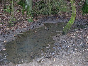
 The Wittekindsquelle not far from the Reineberg |
|||
| location | |||
| Country or region | District of Minden-Lübbecke ( North Rhine-Westphalia ) | ||
| Coordinates | 52 ° 17 ′ 44 " N , 8 ° 38 ′ 7" E | ||
| height | 232 m above sea level NHN | ||
|
|||
| geology | |||
| Mountains | Wiehengebirge | ||
| Hydrology | |||
| River system | Weser | ||
| Receiving waters | Ronceva → Flöthe → Große Aue → Weser → North Sea | ||
Coordinates: 52 ° 17 ′ 44 ″ N , 8 ° 38 ′ 7 ″ E
The Wittekindsquelle is a small spring in the Wiehengebirge in the urban area of Lübbecke in North Rhine-Westphalia . It is located in the area of the Reineberger Hagens at an altitude of 232 meters above sea level. NN and is named after the Saxon Prince Wittekind .
description
At first glance, the spring looks like a small pond. The actual spring is located on the mountain side at the edge of the pond, almost at the level of the water level - water flows from a small hole in the rock that is dammed in a recess too described. The source is about 200 meters southeast of the Reineberg, on the summit of which Reineberg Castle once stood. The spring was of great importance for the supply of drinking water for this castle . The catchment area of the source itself, however, is the northern roof of the Heidbrink , whose 320 meter high summit rises around 800 meters south of the source.
The water temperature of the pond differs from that of other still waters in this area; Usually the water temperature of a source corresponds to the local mean annual temperature of the air and is constant over the season. In Lübbecke, the long-term average annual temperature is 8.9 ° C, the temperature of the spring water from the Wittekindsquelle is therefore barely 8 ° C due to the altitude. Due to the shaded location on the north side of a mountain, the pond water is only slightly heated, even in summer. Among other things, this has a strongly slowing effect on the metamorphosis of the amphibian brood living in the water - tadpoles can often still be found there in midsummer.
A bench was set up next to the spring in September 2006 by the Friends of the Forest Farmers in Lübbecker Land eV In contrast to the spring at the foot of the neighboring Wurzelbrink , the Wittekinds spring is no longer used by people. A stream feeds from it, which flows between the Reineberg and the Heidkopf in the direction of Lübbecke, but continues to flow "underground" in the sewer system immediately after it leaves the forest and then flows into the Ronceva .
Fight against the impending siltation
In recent years it has happened that the small body of water has dried up, sometimes for months. This effect was mainly due to the periodically lower source flow, but intensified by the fall of leaves, so that there is a risk that this silting process may continue and the occasional drying out manifests itself as a permanent state. In December 2017, committed citizens of the city of Lübbecke restored the original state of the source as a biotope through appropriate excavation work; Around 30 cubic meters of leaves and digested sludge were removed from the spring region, so that a body of water around 50 cm deep has arisen again, so that, at least the hope is that a certain water level will be maintained even during a longer dry period.
Oberdorfer Bach
The Wittekindsquelle is in a certain way the source of a brook that flows down below the source between the Reineberg and the Heidkopf. The flowing water known as Oberdorfer Bach (in the vernacular often incorrectly called Wittekindsbach) flows into an underground canal system after a few hundred meters, approximately at the level of the forest sports field.


