
Luebbecke
| coat of arms | Germany map | |
|---|---|---|

|
Coordinates: 52 ° 18 ' N , 8 ° 37' E |
|
| Basic data | ||
| State : | North Rhine-Westphalia | |
| Administrative region : | Detmold | |
| Circle : | Minden-Lübbecke | |
| Height : | 104 m above sea level NHN | |
| Area : | 65.04 km 2 | |
| Residents: | 25,541 (Dec. 31, 2019) | |
| Population density : | 393 inhabitants per km 2 | |
| Postal code : | 32312 | |
| Primaries : | 05741, 05743 | |
| License plate : | MI | |
| Community key : | 05 7 70 020 | |
| LOCODE : | DE LBE | |
| City structure: | 8 districts | |
City administration address : |
Kreishausstrasse 2-4 32312 Lübbecke |
|
| Website : | ||
| Mayor : | Frank Haberbosch ( SPD ) | |
| Location of the city of Lübbecke in the Minden-Lübbecke district | ||
  |
||

Lübbecke [ ˈlʏbɛkə ] ( Low German : Lübke ) is a middle district town in the northeast of North Rhine-Westphalia . With around 26,000 inhabitants, the East Westphalian city belongs to the Minden-Lübbecke district in the Detmold administrative district . It is located on the northern slope of the Wiehengebirge at the transition to the North German Plain . Lübbecke was first mentioned in writing in 775 as hlidbeki and has had city rights since 1279.
geography
location


Lübbecke is located in the northeast of North Rhine-Westphalia , in the north of East Westphalia-Lippe , in the southwest of the Minden-Lübbecke district . The city is located in the west of the cultural and historical region of the Mindener Land . In terms of nature, a large part of the urban area belongs to the North German Plain . Only the southern areas of the city lie on the northern slope of the Wiehengebirge low mountain range , whose ridge in the south largely marks the border of the city. The mountains cover around a fifth of the urban area.
The historic old town and the old centers of most of the villages lie on the edge of the mountains. The remaining areas are more rural. The Mittelland Canal forms the northern city limits. In the northeast of the city lies the Great Peat Bog , now the largest bog in Westphalia . Between the humid lowlands south of the Mittelland Canal, the glacial valley of the Ice Age Weser, and the heights of the Wiehengebirge there is a narrow border of fertile loess soils called Lübbecker Loessland at the foot of the mountain . North of the lowland lies the not so fertile, partly sandy, partly boggy Rahden-Diepenauer Geest . In the Geest are the localities of Stockhausen and Alswede as well as part of the Lübbeck industrial area.
The highest mountains in Lübbeck are the Heidbrink ( 320 m ), the Wurzelbrink ( 319 m ) and the Kniebrink ( 315 m ). The closest to the city center are the Reineberg ( 276 m ), the Heidkopf ( 273 m ) and the Meesenkopf ( 226 m ). The mountains in the south of the city of Lübbecke are the highest in the entire Wiehengebirge. In the north, the area only reaches a height of around 50 m . The lowest point is around 48 m .
Waters
Since the watershed of the Wiehengebirge forms the southern city limits, almost the entire city area is drained to the north, with the exception of a few areas of marginal extent on the southern slope of the Wurzelbrink . As a rule, the short mountain streams, some of which arise at the foot of the mountains and reach the lowlands after a short distance, flow to the north, and then flow into the Flöthe or another larger river beyond the city limits, such as the Ronceva , which flows from "Lübbecker Berg" crosses the city center (mostly piped) and over the Flöthe and the Große Aue . which touches the city in the far west, reaches the Weser . Funded "mountain spring water" is still of great importance for beer production in Lübbecke.
The city of Lübbecke is poor in natural standing water. Both the canal and the lakes and ponds in the bog are man-made. The largest bodies of water are the Mittelland Canal itself with around 50 hectares of water in the Lübbeck area, as well as an unnamed lake in the moorland, which has a contiguous water surface of around 9 hectares. All other bodies of water are smaller than 1 hectare. A total of 1.5 percent of the urban area (98.2 hectares) consists of water bodies.
Geology and resources


Geologically, the surface is mainly determined by Quaternary unconsolidated rocks ( sand , gravel , loess , clay till mostly from the Pleistocene ). Rocks from the Jura , such as sandstones , also come to light in the Wiehengebirge .
Up until the 19th century, Portasandstein was mined in the Wiehengebirge, in the Reineberger Hagen up to the Heidbrink, which is still around three meters thick in Lübbecke, as evidenced by countless small, abandoned quarries in the Wiehengebirge. In the Wiehengebirge, limestone was mined in a large quarry until the 1990s for use as gravel for building houses and roads. It appears that ores were also mined centuries ago; there is an old tunnel at Horst Höhe .
Until the middle of the 20th century, the fossil fuel peat was cut in the large peat bog , mainly for use in domestic fires . Old transport systems (lorries) were still there until a few years ago. However, due to the exhaustion of the deposits and for reasons of nature conservation, production was discontinued.
Despite the great natural gradient, hydropower cannot be used as an energy source today, as the mountain streams have little water in them due to the small catchment area of the mountain streams. In the past, several watermills were operated in the city area. A water mill wheel can still be seen today at the foot of the Wurzelbrink in the Eilhausen district. The use of the natural resource wind power has grown significantly recently. Windmills, etc. a. in Eilhausen, show that this energy source has been used since ancient times. The use of the wind is favored by its location in the North German Plain.
Lübbecke is almost consistently well or very well suited for the use of geothermal heat sources by means of geothermal probes and heat recovery through heat pump heating .
Expansion and use of the urban area


The city has a total area of 65 km². The urban area has a maximum west-east extension of 13 km, the maximum north-south extension is around 9 km.
The area of the city is mainly used for agriculture. Essentially only the Wiehengebirge is forested. The following table provides an overview of the land use (as of 2014):
| Area according to type of use |
Agricultural area |
Forest area |
Settlement and traffic areas |
Surface of water |
other use |
|---|---|---|---|---|---|
| Area in ha | 3,300 | 1,357 | 1,513 | 93 | 241 |
| Share of total area | 50.7% | 20.9% | 23.3% | 1.4% | 3.7% |
The most densely populated is the fertile Lübbecker Loessland with an average population density of 600 to 1000 inhabitants / km². The lowlands south of the canal are very sparsely populated. The Wiehengebirge and the Great Peat Bog are uninhabited. The most densely populated part of the city is the Lübbeck core city with around 800 inhabitants per km² compared to an average of 250 residents per km² in the other parts of the city.
The area share of the agricultural area is lower than the district average (66%), but is slightly above the national average (49.7%). The fertile soils of the Lübbecker Lössland with arable land of 75 are mainly used for arable farming, especially for grain and root crops. Occasionally there are also special crops, e.g. B. Strawberries and orchards. Apart from sporadic areas south of the mountains, grassland is particularly well represented in the north with its poorer and wetter soils. To the east of the industrial area, meadows and pastures take up almost the entire area. Within the nature reserve peat bog , but still outside the actual bog, there is almost only extensive pasture management for ecological reasons, mainly by sheep. From an agricultural point of view, the central high moor area itself is unland and is not cultivated.
The closed forest area of the Wiehengebirge in Lübbecke was originally a mixed beech forest and is now largely converted into a spruce forest. In the lowlands there are only very small groves, which together cover almost 1 km², including the Stockhauser Busch , small forests in the area of the marina and the birch forests in the large peat bog. Part of the moor is covered with closed birch stands. The relative proportion of forests is almost twice as high as the district average (11.2%).
The relatively large proportion of "other area" results from the large peat bog. Moors, heath and unpaved land cover around 3.6 percent of the urban area.
Neighboring communities
Lübbecke is completely surrounded by communities in the Minden-Lübbecke district. In the north lies the city of Espelkamp across the Mittelland Canal . The common border is around 10 km long. In the east lies the municipality of Hille . To the south of the city on the other side of the Wiehengebirge lies the municipality of Hüllhorst . The ridge of the mountains forms the southern city limits over a length of around 10.5 km. In the west, Lübbecke borders on the city of Preußisch Oldendorf . Here the eastern edge of the Hollwinkeler Holz and the Great Aue for 1 km form a natural border.
City structure

According to §3 of the main statute, the area of the city of Lübbecke is divided into the following localities (as of December 31, 2014):
| District | Residents | proportion of | surface | Population density |
|---|---|---|---|---|
| Alswede | 1.004 | 3.9% | 2.95 km² | 340 inhabitants / km² |
| Blasheim | 1,404 | 5.4% | 6.46 km² | 217 inhabitants / km² |
| Eilhausen | 720 | 2.8% | 3.59 km² | 201 inhabitants / km² |
| Gehlenbeck | 3,175 | 12.2% | 11.13 km² | 285 inhabitants / km² |
| Core city | 15,217 | 58.4% | 17.81 km² | 854 inhabitants / km² |
| Nettelstedt | 2,527 | 9.7% | 8.49 km² | 298 inhabitants / km² |
| Upper muscles | 1,274 | 4.8% | 9.26 km² | 138 inhabitants / km² |
| Stockhausen | 747 | 2.9% | 5.36 km² | 139 inhabitants / km² |
| City of Luebbecke | 26,068 | 100% | 65.05 km² | 401 inhabitants / km² |
Lübbeck's core city , which occupies the rest of the area and has almost 16,000 inhabitants, is not a town in the sense of the main statute . Thus almost 62% of the residents live in the Lübbeck core city. A mayor is elected for each town by the town council. The localities as well as the core city are usually referred to as "districts".
The development of the localities of Gehlenbeck and Eilhausen is now seamlessly connected to that of the core city, which means that they have lost their own village character and now form a residential area of Lübbeck. Most of the localities and the core city each comprise, apart from the actual settlement centers, more or less large portions of the Wiehengebirge and the areas with few settlements in the course of the Mittelland Canal. Only the areas of the localities of Alswede and Stockhausen are restricted to the respective locality and the area directly adjacent to it.
climate

Lübbecke is located in the North German Plain in the oceanic-continental transition area of Central Europe from the subatlantic maritime climate and the continental climate . The winters are mostly mild under the influence of the Atlantic, the summers are moderately warm and the rainfall is relatively evenly distributed. Westerly and southwesterly winds predominate, which bring precipitation with them. Due to the location in the lee of the Wiehengebirge and Teutoburg Forest , the precipitation is overall lower than in most of the low mountain range regions of East Westphalia, only the higher altitudes of the mountains are somewhat more precipitous. The annual rainfall is 680 mm in the northern parts of the city and around 800 mm in the mountains.
The average annual air temperature is 8.9 ° C, the warmest month is July at 16.9 ° C, and the coldest is January at 0.8 ° C. On an average of 37 days from November to March, the mean daily temperature is below 0 ° C. The number of hours of sunshine is 1435 hours a year, with a seasonal variation of 200 hours in June and 32 hours in December. On August 26, 2010, 143.3 liters of rain per square meter were recorded in Lübbecke, one of the highest amounts of precipitation in one day in northwest Germany. On this day, a fifth of the amount of rain fell on Lübbecke on average over the whole year.
hairdryer
Lübbecke is considered the foehn capital in OWL. The relatively low Wiehengebirge running in east-west direction ensures that this weather phenomenon occurs so clearly with southerly wind that z. For example, people with hair dryer sensitivity have more symptoms of the hair dryer disease (e.g. headaches) and the weather in Lübbecke is much brighter than south, on the other side of the mountains. On April 14, 2016 e.g. B. on the windward side of the Wiehengebirge the sun shone for only five minutes, while Lübbecke reported five hours of sunshine.
history


The place Lübbecke is first mentioned in writing in 775 as hlidbek in the Frankish imperial annals . At that time, Saxons attacked a Frankish army camp. Lübbecke was the central place of the Saxon hlidbeki- Gau . At this time a church could already have been built in hlidbeki in the course of the Christianization of the local Saxon Engern , which was operated by Charlemagne . Lübbecke was the center of an early church game in the diocese of Minden and so the aristocratic families residing in the area, such as the knightly family of Lübbecke, were in the ministry of the bishops of Minden.
In 1279 Lübbecke was granted city rights by the Minden Bishop Volkwin V. von Schwalenberg . The area was controlled by the bishops of Minden from the state castle of Reineberg (today Hüllhorst ). The gentlemen employed there came predominantly from the knighthood of Lübbeckes. The Burgmannshöfe in Lübbecke belonged to the castle as a fief . In 1806 twelve of these Burgmannshöfe were recorded in the city. The Burgmannen also had a majority in the city council, which met in the town hall, first mentioned in 1460.
A 1274 in Ahlden an der Aller founded Kanonikerstift was after interim stay 1280 in Neustadt am Rübenberge to 1295 according to the Lübbecke Andrew's Church St. relocated where it was until the repeal in the year 1810th 4 Kapitelhöfe in the city were assigned to the monastery . In 1549 the diocesan synod met under Bishop Franz von Waldeck . The Lutheran Reformation was introduced in 1550 .
In the Peace of Westphalia in 1648, the now secularized Prince Bishopric of Minden fell to the Elector of Brandenburg as the Principality of Minden . The town hall burned down in 1705 and was rebuilt in 1709. The Prussian government authorities ordered the division of the mark in 1765 , which generated a large part of the city's income through the granting of collection rights and income from hunting. Lübbecker protests against the division of trademarks were unsuccessful. The medieval fortifications were preserved until the beginning of the 19th century. Due to the high cost of maintenance and the low military usefulness, the fortifications were razed by 1830, the material was used as building material and the ramparts were transformed into promenades.
Until the establishment of the de facto French dominated Kingdom of Westphalia in 1807 and the introduction of French administrative structures, the castle team remained an important power factor in the Prussian town of Lübbecke. A patriciate could hardly develop. The commercial bourgeoisie was represented with six senatorial seats in the city council and provided a bourgeois mayor, who headed the city together with a noble mayor, but the knights remained decisive. The “Town Hall Regulations” issued by the Prussian government in 1727 institutionalized this dual leadership and only provided for two senatorial positions.
In the Kingdom of Westphalia, Lübbecke was the canton capital in the Weser department and Minden district, and remained so when it fell directly to France in 1811 (from 1811 Département de l'Ems-Supérieur ). In 1813 Lübbecke became Prussian again and after a short membership in the civil government between the Weser and Rhine it became part of the Prussian province of Westphalia . After extensive administrative reforms and the dissolution of the Principality of Minden, Lübbecke was part of the newly created administrative district of Minden and the district of Rahden . In 1832 Lübbecke became the administrative seat of the Rahden district, which had been enlarged by parts of the dissolved Bünde district and was renamed the Lübbecke district accordingly .
As almost everywhere in Minden-Ravensberg , the textile industry initially developed in a proto- industrialist form, which was later promoted by the Prussian state with the construction of the Cologne-Minden Railway and its Bünde-Rahden branch line, which opened in 1899 . In Lübbecke, the cigar industry developed into an important economic factor from around 1860 . In 1863 August Blase founded a cigar factory, which in 1938 already had 6,000 employees. This includes the employees who cut, rolled and pressed the cigars in the numerous branches and often working from home in the stalls . The textile and tobacco industry are represented in Lübbecke to this day, although their importance has now lagged behind the importance of mechanical engineering and other branches of industry.
In 1907 the last section of the Mindener Kreisbahnen to Lübbecke was opened (Minden - Hille - Eickhorst 1903). In the 1950s, the meter- gauge narrow - gauge railway was converted to standard - gauge operation due to freight transport . Operations ceased in 1974 and the tracks between Hille and Lübbecke were dismantled. In 1912 the first houses were connected to the electricity supply from the Lower Saxony power plants . The gas factory at Hahlerbaum was founded as early as 1899 as a forerunner of today's municipal utilities . From 1934 Lübbecke had a central water supply.
From the Second World War to the present

During the Second World War , the Waffen SS moved into quarters in Lübbecke and the surrounding villages in October 1944 in preparation for the Ardennes offensive . The Waffen-SS staff was housed in the Gau training castle , which was built on the initiative of the Lübbeck NSDAP district leader Ernst Meiring and inaugurated on June 11, 1939 by the Gauleiter of Westphalia-North, Alfred Meyer . In November the Waffen SS withdrew and the confiscated buildings were vacated again. Lübbecke was largely spared from bombing and was hardly destroyed, since it was intended as the headquarters of the British occupying forces.
On April 3, 1945, Lübbecke was occupied by British troops without major resistance. The headquarters of the British were established in nearby Bad Oeynhausen , but Lübbecke received administrative bodies and military staff units. To this end, 251 of the 432 houses in Lübbecke were confiscated as living space for the Allies and almost the entire city center was cordoned off as an extra-territorial zone because all the main administrative buildings of the urban infrastructure went to the British. The tax office on Kaiserstraße was chosen as the seat of the British zone administration. This building remained the seat of British military staff even after the establishment of the Federal Republic, most recently the headquarters of the 2nd British Armored Division, which withdrew in 1983. The key monument on the Gänsemarkt commemorates “the stay of the headquarters of the 2nd British Armored Division in Lübbecke 1958 - 1982. ... The 2nd Armored Division and the city of Lübbecke have crossed keys as emblems. The double crossed keys of the sculpture symbolize the close friendship that existed between the headquarters and the city during this period. "
On October 17, 1948, the first city council after the war was freely elected.
Incorporations

During the municipal reform in accordance with the Bielefeld Law , which came into force on January 1, 1973, the Minden and Lübbecke districts were merged to form the Minden-Lübbecke district and the district administration was concentrated in Minden . The city of Lübbecke was expanded to include the communities of Blasheim, Gehlenbeck, Eilhausen, Nettelstedt and the Alswede farmers. In the south, the city gained the Reineberger Hagen .
Before the municipal reform and the reorganization of the area with effect from January 1, 1973 (cf. Bielefeld Act ), the current localities formed their own municipalities in the Gehlenbeck office (Nettelstedt, Eilhausen, Gehlenbeck) or were farmers' associations belonging to the municipality (Obermehnen, Blasheim, Stockhausen and Alswede). Obermehnen, Stockhausen and the eponymous farmers in Blasheim belonged to the municipality of Blasheim ( Amt Preußisch Oldendorf ). The Alswede farmers gave their names to the municipality and the Alswede office.
Most of the incorporated areas were located south of the Mittelland Canal, the. since 1973 forms the border to the city of Espelkamp . In the south, Lübbecke had received part of the Wiehengebirge, the Reineberg and the northern roofing of the Heidbrink , i.e. the Reineberger Hagen , which once belonged to the municipality of Ahlsen-Reineberg ( Hüllhorst district ) , but had to cede an approximately 57 hectare strip of forest to Hüllhorst; the border was moved back to the Kammweg.
Population development

- Lübbecke according to the territorial status at that time
|
|
- Lübbecke according to the current territorial status
|
|
- footnote
1 census result
religion

The Evangelical Lutheran population in Lübbecke belongs to the Lübbecke parish with parishes in Lübbecke, Blasheim, Gehlenbeck and Nettelstedt; part of the parish Alswede also in Lübbecke.
The only Catholic parish in Lübbecke with a church on Niederwall is St. Johannes Baptist. There are also some other Christian and non-Christian religious communities, for example the DITIB - Turkish Islamic Community in Lübbecke e. V in Gehlenbeck.
politics
mayor
In the mayoral election on September 13, 2015, the SPD candidate Frank Haberbosch prevailed with 59.00%, ahead of the opposing candidate Dirk Raddy (CDU) with 41.00%. The previous incumbent Eckhard Witte (CDU) was no longer available for re-election.
City council
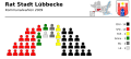
The city council of Lübbecke currently has 38 seats. In addition, the mayor is the council chairman. The following table shows the local election results since 1975:
| 2014 | 2009 | 2004 | 1999 | 1994 | 1989 | 1984 | 1979 | 1975 | ||||||||||
|---|---|---|---|---|---|---|---|---|---|---|---|---|---|---|---|---|---|---|
| Political party | Seats | % | Seats | % | Seats | % | Seats | % | Seats | % | Seats | % | Seats | % | Seats | % | Seats | % |
| SPD | 16 | 42.22 | 15th | 38.04 | 14th | 38.29 | 14th | 36.76 | 18th | 42.39 | 20th | 49.95 | 19th | 48.63 | 20th | 52.03 | n / a | 48.12 |
| CDU | 11 | 29.83 | 14th | 35.61 | 13 | 35.00 | 16 | 42.42 | 14th | 34.49 | 12 | 30.94 | 15th | 37.24 | 16 | 41.05 | n / a | 38.70 |
| Green | 3 | 9.33 | 3 | 8.61 | 3 | 7.41 | 2 | 5.67 | 4th | 10.16 | 4th | 9.90 | 3 | 8.38 | - | - | - | - |
| FDP | 2 | 4.11 | 3 | 7.46 | 3 | 6.80 | 2 | 5.16 | 0 | 4.54 | 3 | 9.20 | 2 | 5.75 | 3 | 6.92 | n / a | 7.17 |
| WL 1 | 4th | 9.53 | 2 | 5.50 | 3 | 7.37 | 4th | 9.99 | 3 | 8.41 | - | - | - | - | - | - | - | - |
| LK 2 | 2 | 4.91 | 1 | 3.85 | 2 | 5.06 | - | - | - | - | - | - | - | - | - | - | - | - |
| Individual applicants | 0 | 0.06 | 0 | 0.93 | 0 | 0.08 | - | - | - | - | - | - | - | - | - | - | - | - |
| FWG 3 | - | - | - | - | - | - | - | - | - | - | - | - | - | - | - | - | n / a | 6.01 |
| Total 4 | 38 | 100 | 38 | 100 | 38 | 100 | 38 | 100 | 39 | 100 | 39 | 100 | 39 | 100 | 39 | 100 | n / a | 100 |
| voter turnout | 47.88 | 56.57 | 59.02 | 59.11 | 83.54 | 69.91 | 73.12 | 78.04 | 87.15 | |||||||||
1 Lübbecke voter community
2 Lübbecke concrete
3 Free voter community
4 without taking into account rounding differences
Allocation of seats in the city council from 2009 to 2014

For comparison: the distribution of seats in the city council from 2004 to 2009

Overview of the election results


coat of arms

The coat of arms shows in silver (white) a red gate with two tinned towers and a blue, open gate with two silver (white) slanted keys with turned away beards; between the towers a golden (yellow) six-pointed star.
The right to use this coat of arms, a flag and a seal was granted to the city on October 7, 1974 by the district president . The flag of the city shows this coat of arms on a red and white striped flag. The outlines of the coat of arms are also shown in the city seal.
The six-pointed star, which also appears in the coats of arms of the dissolved Detmold district , the city of Preußisch Oldendorf and Schieder-Schwalenberg , is closely related to the noble family of the von Schwalenberg family . This symbol found its way into the coat of arms of Lübbeck through the granting of town charter in 1279 by Minden Bishop Volkwin V. von Schwalenberg , whose crossed keys, the keys of St. Peter , are also part of the Lübbeck coat of arms.
The oldest representations of the coat of arms show a bishop on a throne under an archway instead of the key. Later depictions from the 14th century only show the key and the star. Initially, the star was shown on a separate sign. In the 16th century the coat of arms was mostly shown in silver (white) and red and the separate shield for the star was omitted. The colors silver and red, which still dominate the coat of arms today, are the colors of the bishops of Minden. After the regional reform, the city of Lübbecke has the coat of arms in its current form.
Town twinning
Lübbecke maintains partnerships with the following municipalities:
- Bayeux in France since 1968: The partnership is currently focused on student exchanges and internships. The Kantorei an St. Andreas is - together with the Dorchester Choral Society - friends with the Orpheon de Bayeux, a choir association.
- Dorchester in Dorset, Great Britain since 1973: joint sports and music events, church activities. Vocational college in Lübbecke has a partnership with the college in nearby Exeter .
- Tiszakécske in Bács-Kiskun County , Hungary since 1989: based on sporting relationships between local clubs. The Lübbeck craft training center has built a Westphalian half-timbered house in Hungary.
- Bad Liebenwerda in Brandenburg, Germany since 1990: Help from Lübbecke, especially in the development phase of the city administration
Sponsorship
Since 1960 the city has sponsored the Bundesheimatgruppe Striegau Stadt und Land eV In a home parlor in the museum of the city of Lübbecke, memories of the homeland of the Striegau people in Silesia, who were expelled after the war , are preserved. The bell of the Catholic Church in Striegau has been hanging in the wall of the Burgmannshof since 1986. Every two years the federal home meeting of the former Striegau citizens takes place in Lübbecke. The old Striegau bell rings this in.
Culture and sights
theatre
The Nettelstedt open-air theater, founded in 1923, is an amateur theater stage with around 900 seats. The open-air theater Kahle Wart is right on the border of the city, but already in the Hüllhorster area. In the town hall, which holds around 650 spectators for theater events, plays and concerts are regularly held by guest ensembles.
music
The numerous trombone choirs, for example the Nettelstedt trombone choir, emerged from Pietist trumpet movements of the late 19th century and continue to exist today. A choir of the same name belongs to the Church of St. Andrew.
There is the Lübbecke Jazz Club in Lübbecke . In 1922 a “people's choir” was founded in Gehlenbeck. The idea came from the workers of the then numerous cigar factories, who often sang songs at work and wanted to pursue their pastime in a club.
The Lübbecke Symphony Orchestra was founded as a registered association in 1950 and celebrated its 60th birthday in the 2009/2010 concert season. Soloists are recruited from among the teachers of the Pro Musica Lübbecke music school .
Museums

- Brewery museum Barre's Brauwelt : The museum shows the history of the brewery and beer brewing in general in a former storage cellar of the local brewery.
- Museum of the City of Lübbecke: In the old town hall on the market, an extensive collection of costumes, a cigar-making room and a shoemaker's workshop as well as other exhibits on the city's history are on display, including coins, weapons, paintings and silver jewelry from the 16th to 19th centuries. The oldest finds come from the Bronze Age. The city history collection is largely due to the Lübbeck merchant Rudolf Hunke († 1930). The Museum of the City of Lübbecke also houses the Striegau collection (until 2007: Heimatstube Striegau) on the history and culture of the Silesian city of Striegau and on Striegau's greatest son, the poet Johann Christian Günther .
- The Gehrmker Hius in Gehlenbeck offers an insight into village life in the past.
Buildings in Lübbecke
See also → List of architectural monuments in Lübbecke
- Evangelical parish church of St. Andrew . The church was built in Romanesque style from 1160 to 1180 and converted into a Gothic hall church in 1350 .
- The ruins of Reineberg Castle are located on the Reineberg, the local mountain of the Lübbecker family. The facility, first mentioned in a document in 1221, was largely demolished in 1723. Today only wall and moat remains can be seen.
- Former town hall (culture and media center). The town hall, first mentioned in 1460, was largely rebuilt after a city fire in 1709. It is a two-storey plastered solid building with a gable roof. During the renovation work carried out in 1861, it was given a neo-Gothic stepped gable. The eastern extension with the adjoining fire-fighting tower, whose pointed arched ground floor arcades take up the shape of the gable, was added in 1936. In 2006–2007 the building was converted into a culture and media center and an annex was added to the rear.
- Residential buildings. Although Lübbecke was largely spared the destruction of the Second World War, the old town no longer offers a closed picture. Until the middle of the 20th century, the streets were dominated by simple, gable-side half-timbered buildings, most of which came from the 18th and 19th centuries. Many of them were provided with utluchten . Only the urban redevelopment carried out since the late 1960s led to significant losses within the historical building stock. The market square was particularly hard hit, the rebuilding of which with residential and commercial buildings in 1966 a. a. the Tribbenhof fell victim. In 1975, Blüttenstrasse 6, one of the most beautiful half-timbered buildings in the city, was demolished, the gable of which protruded twice over Knaggen . The house of the Hecht family, Ostertorstrasse, rises up from the still preserved stone residential buildings . 7 emerges. The classicistic plastered building with a medium risalit was built in 1832 as the “Berliner Hof” hotel. The outside staircase removed in the 1950s was reconstructed in the 1990s. The so-called old pharmacy is located on Niedertorstrasse . The two-storey half-timbered house with a mansard roof was built in 1820. - Other half-timbered buildings have u. a. on Langen Strasse (e.g. nos. 23, 25, 26 and 44) and in the vicinity of the Andreaskirche, including the curia of the Stiftsdekans , Pfarrstrasse 3 from the late 18th century. At Wilhelmsplatz 1 is the single-storey parish widow's house , whose history can be traced back to the 18th century. It was extensively renovated in 2002 and now serves as a guest house.
- Burgmannshof von der Recke , Am Markt 19 (local history museum). The two-storey plastered solid building with an outside staircase is marked in 1735 above the main portal, but its core is probably older. Obtained is next to the mansion a part of the court wall and the door, and the restored in 1985 memory .
- Grapendorfs Hof (citizens' meeting place), Rechtsstrasse 5. Only the manor house, which was originally thought to date from the end of the 16th century, remained of the courtyard that was formerly made up of several buildings. Damaged in a city fire in 1734, the farm was restored that same year. Today it presents itself as a simple, seven-axis plastered building with a mansard roof, the outside staircase of which has recently been removed for traffic reasons. In 1828 the former Burgmannshof was acquired by the tax authorities in order to be able to use it as a city court. In 1845–1846 the building was expanded to include a northern extension, also with seven axes, which served as a district prison. In 1988, after the district court was moved to a larger building, the complex became the property of the city, which then converted it into a meeting place for citizens. This could be opened in 1993. The old district court is used by numerous groups today.
- Barre Brewery . The oldest parts of the building were erected shortly after the brewery was founded in 1842. The facility is dominated by the brewhouse adorned with a Gothic tower .
- On the second highest mountain, Wurzelbrink ( 319 m above sea level ), which belongs entirely to the city, stands the 19th century watchtower .
- Beer fountain: the fountain, donated by Ernst-Ludwig Barre in 1954 , is located at Burgmannshof and donates beer once a year to the beer fountain festival .
- The listed Villa August Wilhelm Blase .

Gänseliesel on the goose market

Altar with Westphalian Last Supper and crucifix in St. Andrew's Church

Memorial stone at the location of the former synagogue in front of the parking garage East

Beer fountain on the market square

At the Burgmannshof - view of the old town hall


Buildings in the districts


- The St. Nicholas Church in Gehlenbeck was built around 1495. The tower of the Gehlenbeck church is much older and was probably built between 1100 and 1150. A previous building must have existed as early as the 10th century, as has been proven by excavations. A church was first mentioned in 1156.
- St. Andreas Church in Alswede : Church largely built from the destroyed Mesenburg above Lübbecke.
- Gehrmker Hius : The Gehrmker Hius in today's style is a half-timbered farmhouse from 1798. It is now used as a home.
- Königsmühle Eilhausen : The Galerieholländer in Eilhausen was built in 1748 and has a round mill tower made of sandstone. The mill has a wind rose system and windable sail gate wings . The mill is a station on the Westphalian Mühlenstraße .
- Watermill Eilhausen : The quarry stone building with half-timbered gables could have been built in 1698. The overshot water wheel has a diameter of 2.6 meters. In the 19th century there were many such mills in Lübbecke. The mill is a station on the Westphalian Mühlenstraße .
- Gut Stockhausen : The estate is a moated castle in Stockhausen. The beginnings of the estate go back to at least the 14th century.
- Stockhausen : Stockhausen is characterized by its rural courtyards in the half-timbered houses typical of the regionand the associated heuerling houses . 19 objects are under monument protection. Court oaks , orchards and cottage gardens reinforce the rural impression. In the competition Our village should become more beautiful , Stockhausen was awarded gold several times in 1995. In 1997 Stockhausen was named one of four “cultural model villages” in East Westphalia-Lippe.
- Gut Renkhausen : The complex, which can be classified as a mansion in the Neo-Renaissance style, is based on the walls of an old moated castle, which was first mentioned in 1278.
- Gut Obernfelde : The former manor and manor was first mentioned in 1540.
- Gut Eickel : The Gut Eickel formerly known as Echolte is located near Blasheim. The mention of a knight Eylwart de Echolte shows that the estate may have existed before 1183. In the past, a distinction was made between Gut Groß-Eickel and Gut Klein-Eickel. However, these two goods were combined at the beginning of the 18th century.
- Babilonie : The La Tène-temporal ramparts are located on a mountain in the Wiehengebirge near Obermehnen and could have been a refuge .
- Meesenburg : This weir system at the Meesenkopf is only partially preserved and was probably razed in the 12th century.
Parks


The Gallenkamp , a park-like high open space in the immediate vicinity of the city center, offers a view of the Lübbecker Land. In winter, the Gallenkamp is used by the Lübbeck youth for tobogganing . There is also an elongated park in the Schützenstraße area. Another larger green area close to the city with walking paths extends between the cemetery and the Wittekind high school. These parks are connected to the preferred residential areas, all of which are in the immediate vicinity of the Wiehengebirge.
Outside the city center, a few parks have been created, especially around the estates and castles. These include the following parks, all of which are not open to the public:
- Gutspark Gut Stockhausen : Little has been preserved of the former baroque gardens. A 200-year-old chestnut avenue running in north-south direction leads from the estate to Reck's hereditary burial and was once an element of the garden.
- Gutspark Gut Renkhausen : The historic landscape park was created around 1900 . The central element is the open lawn area, which is interspersed with old trees. The complex includes a landscaped hill and a grotto . The 100-year-old Renkhauser Lindenallee stretches from the estate to the east .
- Gutspark Gut Obernfelde : The Gutspark was probably created together with the orangery that was built around 1829 - today a residential building. The orangery formed the center of a historical landscape park with a relatively complex system of paths and avenues. Only remaining areas south of the orangery remain of the original park.
nature

On a relatively small area of around 65 km², Lübbecke has a very diverse number of different natural and landscape areas and thus different leisure areas: wooded low mountain ranges in the south, high moor in the north-east, wet meadows in the north and north-west, each equipped with a close-knit network of hiking trails and also bike paths. The green strip along the Mittelland Canal with the almost ten kilometer long hiking and cycling path right on the bank also deserves a mention in this context. Around a third of the area of the city can be assigned to these largely uninhabited natural or near-natural landscapes with high recreational value. With the Wiehengebirge, Lübbecke has a share in the TERRA.vita nature park (formerly: Northern Teutoburg Forest-Wiehengebirge nature park ). There are six nature reserves in the city :
- Bastau meadows : 1844 hectares of protected wet meadows along the Bastau . Large parts of the area are in Hille and the city of Minden .
- Finkenburg : 13 hectare area in Blasheim.
- Gehlenbecker Masch : 45 hectare wet meadow area
- Large peat bog : Westphalia's largest raised bog. The 467 hectare nature reserve is also partly in Hille .
- Rauhe Horst - Schäferwiesen : 198 hectares of wet and damp grassland.
- Sonnenwinkel : 4.3 hectares of deciduous forest
The relative area share of designated nature reserves in Lübbecke is, at over 10 percent, significantly larger than the state (7.3 percent) and national average (2 percent). This high value is all the more remarkable because the natural Wiehengebirge except for the above. Sonnenwinkel does not have any other formally designated nature conservation areas.
In Lübbecke, among others, the following larger wild animals live in the city's near-natural forest and moor areas: wild boar and roe deer , fox , badger, especially in the Wiehen Mountains but also in the cultivated areas. In the moor there are u. a. the white stork and the poisonous adder . In addition to Petershagen, the only wild white storks in the state of North Rhine-Westphalia breed in Lübbecke . In the area of the southern core city, the large population of bats is evident, which circle the gardens in summer from dusk.
The 27 designated natural monuments in Lübbecke are made up of 26 solitary trees and groups of trees, including the 120 oaks on Obernfelder Allee, and an old quarry on Obermehner Berg as the only geological object.
Sports
- The long-standing handball league team TuS Nettelstedt-Lübbecke (formerly TuS Nettelstedt) is based in the city. The club won the DHB Cup and the European Cup Winners ' Cup in 1981 . After a few relegations and promotions, TuS has been playing in the Bundesliga again since 2009 . His home games take place in the Lübbecke district sports hall with a capacity of 3,400 . A special rivalry connects the club with the GWD Minden , which is the second Bundesliga club in the Minden-Lübbecke district .
- The Freeway Cup , the “unofficial German U-16 indoor soccer championship”, takes place every year in mid-January in the Lübbecke district sports hall.
- The highest-class football clubs are BSC Blasheim, FC Lübbecke and HSC Alswede (all district league A)
Regular events
The Blasheimer Markt festival takes place on the first weekend in September. The beer fountain festival at the beginning of August is a typical local large event with up to 100,000 visitors annually. The Barre brewery has been brewing beer for seven hours from the beer fountain at Burgmannshof since 1954. The end of July held citizens Marksmen was initiated in 1492, founded by citizens Rifle Battalion. At the festival, a rifle king is shot every two years. The sausage market in November begins with the mayor cutting a “giant sausage ”. The local butcher's trade presents its craft. Rides and other attractions have been set up on the Gänsemarkt and in the pedestrian zone.
Economy and Infrastructure
traffic
Streets
Lübbecke is at the intersection of federal highways 65 and 239 . The city is not directly connected to the motorway network. The A30 motorway (Bad Oeynhausen-Osnabrück) is around 15 km south, the A2 motorway (Cologne-Berlin) is around 30 km away. The “Löhne-Bremen” motorway planned in the 1970s as part of the A 5 , which would have run directly east of the urban area, was not implemented and is no longer included in the federal traffic route plan.
Rail and bus transport

The Lübbecke (Westf) Bahnhof is on the Ravensberger Bahn , on the hourly, Sundays every two hours, the same regional train 71 Bielefeld - Herford - frets - Rahden wrong. Blasheim station was shut down decades ago. Local rail passenger transport is carried out by the Eurobahn , which uses DB class 643 diesel multiple units for speeds of up to 120 km / h.
The public transport in Lübbecke belongs to Tarifverbund Westphalia tariff (power TeutoOWL ). In addition to local public transport, there is an express bus route to Minden and regional buses to Espelkamp , Rahden and Preußisch Oldendorf .
Waterways and ports
The Mittelland Canal forms the northern city limits. Here the city has a connection to the Rhine , Weser and Elbe with the port of Lübbecke . Not far from this harbor there is also a small marina and a dock for rowing boats.
Cycling and walking routes
The largely flat North German Plain favors cycling. The 40-kilometer Lübbecker Landweg connects the districts of the city with one another. The Westphalian Mill Route and the LandArt Route , which connects places of rural handicrafts with each other, as well as the Wellness Cycle Route and the BahnRadRoute Weser-Lippe run through the city . The service path along the Mittelland Canal is also popular as a cycle path .
Of the hiking trails, the Wittekindsweg over the ridge of the Wiehengebirge in the TERRA.vita nature park is probably the best known. The counterpart to the Mühlenroute cycle path is the Mühlensteig , which also connects the mills in the region. The Arminiusweg follows the presumed historical migration route of the Roman army under Varus , which is said to have passed through the Lübbecker Land on its way to the annihilation near Kalkriese . A moor adventure trail leads through the large peat bog . Numerous smaller hiking trails are also signposted in the TERRA.vita nature park. A partial route of the inline skate path Mühlenkreis Skate & Rail also leads through Lübbecke.
air traffic
The nearest airports are Hannover-Langenhagen (approx. 1 hour drive), Münster-Osnabrück (approx. 1 hour drive) and Bremen (approx. 90 minutes drive). On November 5, 2005, a Lufthansa aircraft, a Bombardier CRJ700 with the registration D-ACPQ, was baptized in the name of the city. Nearest commercial airport is the airport Vennebeck , 20 km south-east.
Established businesses

A major employer in Lübbecke is the IMA Klessmann company with around 900 employees. It is an international manufacturer of machines and production lines for the furniture and construction element industry. The Gauselmann AG operates in Lübbecke its production facility for slot machines and employs 1,100 people at this location. With 400 employees, the Meat Center Lübbecke of the Westfleisch company is still a traditional slaughterhouse. Liberty Damenmoden GmbH sells women's clothing. The Dannemann Cigarrenfabrik GmbH is the remainder of a former world market leader and one of the last companies in the tobacco industry in Lübbecke. Around 300 employees produce high-quality cigars and cigarillos here. The family-run private brewery Ernst Barre is located in the pass of the Wittekindsberg .
Most of these companies are located in three industrial areas ("Gewerbegebiet Südlich Jockweg / westlich Heuweg", "Gewerbegebiet Süd-Ost" and "Industriegebiet am Hafen") in the north of the city on the B 239.
media
In the city, the Neue Westfälische (office in Lübbecke) and the Westfalenblatt are represented as regional newspapers with corresponding local sections for the city. The local radio for the Minden-Lübbecke district is Radio Westfalica .
Public facilities

Lübbecke is one of four locations of the Mühlenkreiskliniken . The Veritas Hospice is also located here . As relics of the former district town, the tax office and a registration office of the road traffic office have remained in Lübbecke. Other municipal facilities are the town hall and a media library (formerly the town library) in the culture and media center in the old town hall on the market.
Stadtwerke Lübbecke, founded in 1899, operates the energy and water supply in the city as well as the port on the Mittelland Canal. They are owned by the city with a large majority and in 1995 took over the power grid, which they operate together with their partner RWE Westfalen-Weser-Ems AG . On April 26, 1998, a majority of citizens voted in a referendum against the purchase of the power grid. The city also operates an indoor pool and an outdoor pool in Gehlenbeck . The former Lübbecke outdoor pool was closed after a referendum on May 2, 2004.
The waste from the city of Lübbecke is disposed of in the waste disposal center Pohlsche Heide in accordance with the Waste Act of the Federal Republic of Germany .
The jurisdiction is exercised in the district town of Minden.
education
The secondary schools in the Mittelzentrum Lübbecke accept students from Lübbecke and many of the surrounding communities such as Hüllhorst and Preußisch Oldendorf. The secondary schools include:
- Wittekind-Gymnasium Lübbecke (founded in 1926, around 1000 students, named after the Saxon Duke Widukind )
- Stadtschule Lübbecke (municipal secondary school, founded in 2012, 650 pupils in the 5th to 10th year)
- Vocational college Lübbecke (3700 students, of which 2500 dual training (apprenticeship) and 1200 full-time school courses, qualifications: secondary school certificate to high school diploma)
The secondary school and the Jahn secondary school were closed in 2017.
Lübbecke also has the following six primary schools :
- Astrid Lindgren Elementary School (founded in 1994, named after Astrid Lindgren since 1995 , school building originally English-speaking and St. Peter's School founded after the Second World War )
- Primary school in Blasheim (around 225 students, goes back to a school built in Blasheim in 1890)
- Primary school Gehlenbeck (around 200 students, goes back to the primary school established in 1959)
- Primary School Im Kleinen Feld (around 260 students, name since 1995, founded 1973)
- Grundschule Nettelstedt (around 150 students, founded in 1975, goes back to the former Nettelstedt primary school, old building from 1927)
- Rainbow elementary school (founded in 1993, around 250 pupils, integrated classes with some disabled children)
The city also has a special school :
- School at Buschkamp (focus: intellectual development, around 135 pupils, including 46 severely disabled, sponsor: Ludwig-Steil-Hof )
- The Pestalozzi School (funding focus: learning) was closed in 2019.
In addition to other vocational schools, the Pro Musica music school and the Lübbecker Land adult education center should be mentioned.
Personalities
Honorary citizen
- Huguette Brillaud (for services to twinning with Bayeux)
- Colin Lucas (for services to twinning with Dorchester)
- Paul Gauselmann (for services to the business location Lübbecke and for the commitment to sports sponsoring)
- Helmut Hüffmann (for services to come to terms with the city's history)
sons and daughters of the town
The following personalities were born in Lübbecke:
- Eberhard von der Reck (* 1744 in Stockhausen, † 1816 in Merseburg ), general and politician
- Carl Friedrich Meyer (* 1803 in Lübbecke, † 1886 in Eitorf ), doctor and psychiatrist
- Franz Heinrich Kleinschmidt (* 1812 in Blasheim, † 1864 in Otjimbingwe ), theologian
- Otto von Strubberg (* 1821 in Lübbecke; † 1908 in Berlin ), theologian
- Otto Michaelis (* 1826 in Lübbecke, † 1890 in Berlin), politician, economist and journalist
- Heinrich Cordes (* 1866 in Lübbecke; † 1927 in Breslau ), foreign service interpreter and banker
- Friedrich Husemann (* 1887 in Blasheim, † 1959 in Buchenbach ), anthroposophic doctor and psychiatrist
- Karl Röttger (* 1877 in Lübbecke; † 1942 in Düsseldorf ), writer
- Erich Lossie (* 1886 in Lübbecke, † 1944 in Bielefeld ), sculptor
- Hans Rodenberg (* 1895 in Lübbecke, † 1978 in Berlin), theater scholar and film director
- Emmy Zehden (* 1900 in Lübbecke, † 1944 in Berlin-Plötzensee ), resistance fighter against National Socialism
- Gottfried Husemann (* 1900 in Blasheim, † 1972 in Arlesheim ), doctor and psychiatrist
- Hermann Busse (* 1903 in Lübbecke, † 1970 in Hemer ), politician
- Lore Shelley (* 1924 in Lübbecke; † 2011 in Riverdale (New York) ), writer
- Martin Horstmeier (* 1929 in Stockhausen), farmer and politician
- August-Wilhelm Scheer (* 1941 in Lübbecke), business IT specialist and IT entrepreneur
- Martin Bartsch (* 1942 in Lübbecke), church musician
- Antje Vollmer (* 1943 in Lübbecke), politician
- Gerd Nobbe (* 1944 in Lübbecke; † 2019 in Karlsruhe), judge at the Federal Court of Justice
- Gerd-Axel Ahrens (* 1948 in Lübbecke), traffic planner
- Heinz-Dieter Heckmann (* 1953 in Lübbecke; † 2016 in Münster ), philosopher
- Thomas Lackmann (* 1954 in Lübbecke), journalist
- Martin Heidenreich (* 1956 in Lübbecke), social scientist
- Jens Förster (* 1965 in Lübbecke), social psychologist, director of the Kurt Lewin Institute at the University of Amsterdam
- Andreas Spellig (* 1965 in Lübbecke), journalist and television presenter
- Eyke Hüllermeier (* 1969 in Lübbecke), computer scientist
- Lotte Ohm (* 1975 in Lübbecke), actress
- David Bösch (* 1978 in Lübbecke), theater director
- Nadine Bollmeier (* 1981 in Lübbecke), table tennis player
- Rolf Hermann (* 1981 in Lübbecke), national handball player
- Finn Holsing (* 1983 in Lübbecke), soccer player
Other personalities
The following personalities were not born in Lübbecke, but worked here:
- Otto Piene (* 1928 in Laasphe; † 2014 in Berlin), artist, grew up in Lübbecke
- Ernst Wilm (* 1901 in Reinswalde, Sorau district, † 1989 in Lübbecke), pastor and church official
- Herbert Lübking (* 1941 in Dankersen), handball player
- Eberhard Werner (* 1924 in Glogau / Silesia; † 2002 in Lübbecke), artist (landscape painter) lived and died in Obermehnen near Lübbecke
- Friedrich Langewiesche (* 1867 in Elberfeld, † 1958 in Bünde), researched babilonia
- Siegfried von Campe (* 1885 in Münster, † 1972 in Hanover), politician, trainee lawyer in Lübbecke
- Kurt-Wolf von Borries (* 1928 in Bergen, Belgard district; † 1985 in Cologne), artist, Abitur in Lübbecke
- Christian Rosenbohm (* 1878 in Kleinendorf; † 1948 in Lübbecke), politician, lived and died in Lübbecke
- Hans Wilhelm Stodollick (* 1949 in Dortmund), politician, mayor of Lünen , treasurer in Lübbecke
- Salomon Blumenau (* 1825 in Bünde, † 1904 in Hanover), educator and preacher, student in Lübbecke
- Ernst Weitkamp (* 1908 in Quernheim / Herford district; † 1977 in Lübbecke), dentist, SS-Obersturmführer , after the beginning of the war, head of the dental ward in Mauthausen concentration camp for a short time , member of the Confessing Church, practiced in Lübbecke from 1932 to 1977
- Jürgen Weitkamp (* 1938 in Bielefeld), doctor, dentist, honorary president of the Dental Association Westphalia-Lippe and the German Dental Association , has been practicing in Lübbecke since 1967
- Karl-Friedrich Höcker (* 1911 in Engershausen; † 2000 in Lübbecke), SS-Obersturmführer, adjutant of the concentration camp commanders of Neuengamme and Majdanek (several years imprisonment after the war), lived and died in Lübbecke
- Franz Breithaupt (* 1880 in Berlin; † 1945 in Prien am Chiemsee), lieutenant general of the police and SS-Obergruppenführer , apprentice in Lübbecke
- Cajus Julius Caesar (* 1951 in Rinteln), politician, attended school in Lübbecke
- Marie Schmalenbach (* 1835 in Holtrup; † 1924 in Mennighüffen), poet, lived in Lübbecke
- The Cornbergs were wealthy through Philipp Wilhelm von Cornberg (* 1553 in Kassel, † 1616 in Richelsdorf) in Lübbecke
- Harald Nickel (* 1953 in Espelkamp; † 2019), professional footballer, parent club was 1. FC Lübbecke
- Johann Heinrich Hadewig (1623–1671), Protestant pastor in Lübbecke and hymn poet
literature
- Werner Ernstmeyer: Lübbecke district (art guide of the Westphalian Heimatbund, issue 9). Munster 1937
- Helmut Hüffmann: The St. Andreas Church in Lübbecke. Luebbecke 1990
- Helmut Hüffmann: 1200 years of Lübbecke. 2nd expanded edition, Hüllhorst 1975
- Helmut Hüffmann: A description of the city of Lübbecke according to the reports of its city secretary Consbruch. Messages of the Mindener Geschichtsverein, volume 58 (1986), pp. 137-148.
- Helmut Hüffmann: Lübbecke - tell old pictures (series of archive pictures). Erfurt 1999
- Helmut Hüffmann: Lübbecke and the Lübbecker Land (series of archive images), Erfurt 2003
- Albert Ludorff : The architectural and art monuments of the Lübbecke district. ( The architectural and art monuments of Westphalia. Volume 22), Paderborn 1907.
- Dirk Möllering [Ed.]: Democratic new beginning in the old district of Lübbecke. On the formation and development of political parties after 1945. Lübbecke 1988
- Westphalian city atlas ; Volume: III; 5 part band. On behalf of the Historical Commission for Westphalia and with the support of the Regional Association of Westphalia-Lippe, ed. by Heinz Stoob † and Wilfried Ehbrecht. City folder Lübbecke, author: Friedrich-Wilhelm Hemann, ISBN 3-89115-125-X ; Dortmund-Altenbeken, 1988.
Web links
- Internet presence of the city of Lübbecke
- Architectural monuments (1902) Bielefeld University Library
- Topic page "Lübbecke and East Westphalian villages" on the website of the artist Eberhard Werner from Obermehner
- War memory of the former mayor
- Short film about facts and figures from Lübbeck on Youtube
- Lübbecke in the Westphalia Culture Atlas
Individual evidence
- ↑ Population of the municipalities of North Rhine-Westphalia on December 31, 2019 - update of the population based on the census of May 9, 2011. State Office for Information and Technology North Rhine-Westphalia (IT.NRW), accessed on June 17, 2020 . ( Help on this )
- ↑ Geological Service NRW: Using geothermal energy - Geothermal study provides planning basis ( Memento from September 14, 2005 in the Internet Archive ) (PDF file; 360 kB)
- ↑ a b State Office for Data Processing and Statistics North Rhine-Westphalia: Municipal profile Lübbecke, status: 21.09.2015 ( Memento from April 8, 2016 in the Internet Archive ) (PDF file; 316 kB)
- ↑ a b City of Lübbecke: Main statutes of the city of Lübbecke from January 30, 1995 (PDF)
- ↑ Lübbecke - numbers and dates. Retrieved April 1, 2015 .
- ^ City of Lübbecke: Welcome to Lübbecke. Facts and figures. Climate.
- ↑ Table with amounts of rain ( memento of the original from January 6, 2014 in the Internet Archive ) Info: The archive link was inserted automatically and has not yet been checked. Please check the original and archive link according to the instructions and then remove this notice.
- ↑ Page no longer available , search in web archives: Documentation about Föhn in Lübbecke WDR local time OWL on April 14, 2015
- ↑ Friedrich Föst needs “correct weather” , article with a picture of a foehn wall and foehn clouds over the Wiehengebirge near Lübbecke, hallo-luebbecke.de, April 1, 2012.
- ^ Annales Regni Francorum 775 .
- ↑ Westfälisches Klosterbuch, vol. 1, p. 546f.
- ^ Lecture by the city archivist Helmut Hüffmann to the City Council of Lübbecke on May 4, 1995 , accessed on July 4, 2013.
- ↑ Inscription on the key monument. (No longer available online.) Photo gallery Dr. Olaf Hoffmann, archived from the original on November 21, 2017 ; accessed on November 21, 2017 . Info: The archive link was inserted automatically and has not yet been checked. Please check the original and archive link according to the instructions and then remove this notice.
- ↑ Mayoral elections 2015 on mindener-rundschau.de
- ↑ State database NRW; Election results for the municipality code 05770020
- ↑ The State Returning Officer of the State of North Rhine-Westphalia. Further election results can be found on the page, accessed on August 20, 2013
- ↑ Municipal data center Minden-Ravensberg / Lippe
- ↑ The International Civic Heraldry site: Lübbecke coat of arms.
- ↑ Federal Institute for Culture and History of Germans in Eastern Europe (BKGE): Heimatstube Striegau , accessed on July 5, 2013.
- ↑ Inscription on the memorial stone: “Remember the sacrifice that Jewish citizens brought with their lives”. Inscription on the commemorative plaque in front of the stone: “Jews were able to live in this city for centuries, but during the time of National Socialism, people took away their civil rights, property and some even their lives. The families: Löwenstein, Mansbach, Hurwitz, Wolff, Bloch, Weinberg, Schöndelen, Levy, Mergentheim, Neustädter, Steinberg, Ruben, Hecht, Lazarus, Rosenberg, Schöneberg were persecuted. Their suffering obliges us to be tolerant and politically alert. The Lord said to Cain, Where is Abel your brother? He said: I don't know, shall I be my brother's keeper? (1.Mos. 4,9) "
- ↑ Directory of natural monuments. (PDF; 347 kB) Minden-Lübbecke district, lower landscape authority, accessed on April 17, 2019 .
- ↑ Gauselmann expands its Lübbecke plant , Neue Westfälische, January 8, 2013, accessed on November 15, 2018.
- ^ Website of the Veritas Hospice in Lübbecke
- ^ Neue Westfälische: 5 entry classes for the 114 newcomers ( Memento from January 6, 2014 in the Internet Archive )
- ↑ Helmut Hüffmann is the new honorary citizen of the city of Lübbecke. Neue Westfälische, accessed on July 24, 2015 .
- ↑ Harald Nickel in the Munzinger archive ( beginning of article freely accessible)
Cities: Bad Oeynhausen | Espelkamp | Lübbecke | Minden | Petershagen | Porta Westfalica | Prussian Oldendorf | Rahden . Municipalities: Hille | Hüllhorst | Stemwede .