
Wurzelbrink
| Wurzelbrink | ||
|---|---|---|
 View of the Wurzelbrink from the Reineberg |
||
| height | 318.6 m above sea level NHN | |
| location | near Lübbecke ; District of Minden-Lübbecke , North Rhine-Westphalia ( Germany ) | |
| Mountains | Wiehengebirge | |
| Coordinates | 52 ° 16 '58 " N , 8 ° 36' 54" E | |
|
||
| particularities | Luebbeck watch tower | |

The Wurzelbrink is 318.6 m above sea level. NHN the second highest mountain in the northern German Wiehengebirge . It is located near Lübbecke in the North Rhine-Westphalian district of Minden-Lübbecke . The Lübbecker watch tower , which serves as a lookout tower, stands on the summit .
geography
location
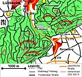
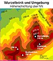
The Wurzelbrink rises in the nature and geopark TERRA.vita . Its summit is 2.2 km south of the core town of Lübbecke within the Lübbecke district. To the south is the large community of Hüllhorst with the district Ahlsen-Reineberg in the east and Oberbauerschaft in the south-southwest. The source of the Ronceva lies on the saddle to the north-eastern neighbor Heidbrink ( 319.6 m ), the highest mountain in the Wiehengebirge . West of the Wurzelbrink is the origin of the Westerbach on the transition area to the southwest located Breitenbrink ( 287 m ) from several short source brooks (see also section Quelle am Wurzelbrink ). To the south-southeast is the Kniebrink ( 315 m ).
Parts of the Wiehengebirge-Wesergebirge landscape protection area extend on the Heidbrink ( CDDA no. 555560799; designated 1971; 49.1049 km² in size).
Natural allocation
The Wurzelbrink belongs in the natural spatial main unit group Lower Weserbergland (No. 53) and in the main unit Eastern Wiehengebirge (532) to the subunit Lübbecker Egge (532.2). To the south, its landscape falls into the natural area of Quernheimer Hügelland (531.01), which in the main unit Ravensberger Mulde (531) belongs to the sub-unit of Quernheimer Hügel- und Bergland (531.0).
Luebbeck watch tower

On the summit of the Wurzelbrink stands the watch tower , built in 1857 , which serves as a lookout tower. From there the view falls over the Mensinger Gorge to the northeast to the Heidbrink. Further in this direction is the large peat bog , about 7 km away between the villages of Gehlenbeck / Nettelstedt and the Mittelland Canal . In the north-northeast, about 21 km away, Stemweder Berg ( 181.4 m ) can be seen. To the east-southeast, the Wiehengebirge continues in a curve to Porta Westfalica 21 km away, which can be seen on a clear day. To the south, the view falls into the hill country of the Ravensberger Mulde, beyond that lies the Teutoburg Forest .
Source at the Wurzelbrink

On the lower part of the western slope of the mountain, in the Westerbach catchment area, a spring rises directly on a hiking trail, which was elaborately framed. No binding and official name has yet been established for the source. The spring gives 10 liters of water per minute in spring. Towards summer, however, depending on the weather, the productivity decreases more or less significantly.

gallery
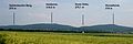
The Wurzelbrink (far right) seen from the north
From Lübbecke the ascent to the Wurzelbrink takes 45–60 minutes

On the northwest flank of the Wurzelbrink, a clearing allows a view of the Lübbecker Land
In addition to the Wurzelbrink, the Kniebrink also exceeds the 300-meter mark

Memorial plaque on the watch tower


Individual evidence
- ↑ a b Map services of the Federal Agency for Nature Conservation ( information )
- ^ Sofie Meisel: Geographical Land Survey: The natural spatial units on sheet 85 Minden. Federal Institute for Regional Studies, Bad Godesberg 1959. → Online map (PDF; 4.5 MB)