
Ronceva
| Ronceva | ||
 Lower Ronceva |
||
| Data | ||
| Water code | DE : 476142 | |
| location | North Rhine-Westphalia , Germany | |
| River system | Weser | |
| Drain over | Flöthe → Große Aue → Weser → North Sea | |
| source |
Wiehengebirge south of Lübbecke 52 ° 17 ′ 19 ″ N , 8 ° 37 ′ 37 ″ E |
|
| Source height | approx. 175 m above sea level NN | |
| muzzle | North of Lübbeck in the Flöthe coordinates: 52 ° 19 ′ 51 ″ N , 8 ° 37 ′ 10 ″ E 52 ° 19 ′ 51 ″ N , 8 ° 37 ′ 10 ″ E |
|
| Mouth height | 51 m above sea level NN | |
| Height difference | approx. 124 m | |
| Bottom slope | approx. 25 ‰ | |
| length | 5.1 km | |
| Medium-sized cities | Luebbecke | |
| Residents in the catchment area | approx. 16,000 | |
The Ronceva (also Roncevabach ), formerly also Ronxava, is a stream that flows through the East Westphalian town of Lübbecke .
course
The source of the Ronceva is 230 m above sea level. NN in the Wiehengebirge between the mountains Heidbrink and Horst Höhe at the lower end of the Mensinger Gorge . The latter is on the eastern flank of the Wurzel and Heidbrink. Thus, the upper reaches of the Ronceva have significant areas of the three highest mountains of the Wiehengebirge in its catchment area. It then flows east of the federal highway 239 to Lübbecke and after a few hundred meters it crosses the Bunte Brücke . In the area of the Lübbeck core city, it flows underground.
North of the city center, the Ronceva comes to light again and finally flows into the Flöthe in the area of the Lübbeck industrial area, right next to the Gauselmann Group building (at 49 m above sea level ) .
The Ronceva has a length of around 5 km, of which around 1.5 km are piped underground. The catchment area of the Ronceva covers around 4 km², i.e. only 7% of the total urban area of the city of Lübbecke.
Despite the relatively short run, the Ronceva flows through three fundamentally different large landscapes: the Wiehen Mountains, then the Lübbecker Loessland and finally the Rahden-Diepenauer Geest .
Historical meaning
The old Saxon name Lübbeckes Hlidbeki , which means little stream (English: little beck , Low German: lüt Beek or lüttke Beke ) goes back to the Ronceva. As a result, it was once a motivation to establish a settlement here because of the creek, as the creek with its gradient in today's urban area offered energy potential for water mills . Therefore, the Ronceva later passed through the eastern moat and around 1750 drove five mills in the city center. Outside the city center in front of the Bergertor (south of the city wall) and the Niedertor (in the north of the city), further mills were driven by the Ronceva. The most famous mill was the Reineberger Amtsmühle . The corresponding half-timbered building on the B239 is still called the Königsmühle today. The Ronceva found itself indirectly in the old coat of arms of the former Lübbecke district . The wavy bar indicated the etymological meaning of Lübbecke, which is derived from Hlid beki, that is, that brook (beki) that is now called Ronceva. The coat of arms colors were the colors of both the principality of Minden and the county of Ravensberg. This old coat of arms was approved by the Prussian State Ministry in 1935 and was replaced by another coat of arms in 1968.


Appearance
Within the urban area, from the Ernst Barre private brewery , it is mostly piped, only in the area of the market square was it exposed again in 1988 and dammed up to form a small pond. In addition, there are considerations to expose the stream in other areas of the city center. In the framework plan for the city center of Lübbecke: "(...) Where possible, an attempt should be made to re-expose the stream as a defining and historical element in the area of the former Ronceva stream (...)" .
Economic and ecological importance
Despite the total gradient of 180 m, the use of the Ronceva's hydropower is no longer relevant due to the low annual water supply. On the other hand, it is important for local sport fishing. You can fish for perch , roach and gudgeon . The Ronceva can be fished from the street "Rote Mühle" to the confluence with the Flöthe. Above Lübbecke, the Ronceva has a water quality class from I to II, and can therefore be described as unpolluted to slightly polluted water in this area. In the area of the Lübbeck industrial area, the brook takes on the drainage of the sewage treatment plant, in which waste water from a meat processing company is also treated, so that the water quality of the Ronceva when it flows into the Flöthe is clearly in the range of quality class III (heavily polluted).

The still “young” Ronceva shortly after her emergence between the “Barre” and “Horst Höhe” breweries near the Reineberg in the Wiehen Mountains

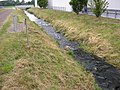
The lower reaches of the Ronceva in the area of the Lübbeck industrial area
Shortly before the estuary, which is behind the bridge in the background, the Ronceva still shows a strong current. Anglers can be seen at the bridge

The mouth of the Ronceva in the flute
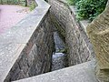
In the vicinity of the market square, the Ronceva was exposed again to a few meters ...

... and then dammed into a small pond before it disappears "underground" again.

The Ronceva is also the subject of the city tour at this point.


Individual evidence
- ↑ a b German basic map 1: 5000
- ↑ Topographical Information Management, Cologne District Government, Department GEObasis NRW ( Notes )
- ^ Friedrich Möllering: Wittekind Sagen, Lübbecke, 1993, p. 12