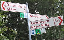
BahnRadRoute Weser-Lippe

The "BahnRadRoute Weser-Lippe" is a long-distance cycle route from Bremen to Paderborn . The cycle path has a length of approx. 350 kilometers (depending on the choice of alternative route sections) and leads through Bremen , Lower Saxony and North Rhine-Westphalia .
description
The long-distance cycle path begins in Bremen and initially leads through the North German Plain , partly along the Weser , to East Westphalia-Lippe . The route has several alternative routes. The sections of the route in Ostwestfalen-Lippe lead through the Wiehengebirge , Ravensberger Hügelland , Lipper Bergland , Teutoburg Forest and Egge Mountains and are therefore more demanding in terms of cycling than the northern part.
The cycle path is designed as a "BahnRadRoute". It is therefore possible in many places to switch to the train and cover parts of the route by train or to start the individual bike tour at an intermediate station. The route runs parallel to the Weser-Hase-Bahn (Bremen– Twistringen ), Ravensberger Bahn , Wiehengebirgsbahn, Begatalbahn (“Der Lipperländer”) and Herford – Altenbeken (“Ostwestfalenbahn”) railway lines .
The following municipalities are on the route:
Bremen, Weyhe , Syke , Bassum , Twistringen , Schwaförden , Sulingen , Kirchdorf , Wagenfeld , Rahden
- Alternative 1: Stemwede
Espelkamp , Preußisch Oldendorf , Rödinghausen , Bünde , Kirchlengern , Hiddenhausen
- Alternative 2a: Herford , Bad Salzuflen
- Alternative 2b: Enger , Bielefeld , Leopoldshöhe , Oerlinghausen
- Alternative 3: Lemgo
- Alternative 4: Steinheim-Sandebeck
Altenbeken , Bad Lippspringe , Paderborn
literature
- BVA Bielefelder Verlag (ed.): “BahnRadRoute Weser-Lippe 1: 50,000. Compact Spiralo (Bielefeld cycling maps) ” . 3. Edition. BVA Bielefelder Verlag, Bielefeld 2008. ISBN 978-3-87073-431-2 .
Web links
Coordinates: 52 ° 16 ' N , 8 ° 31' E
