
Tighter
| coat of arms | Germany map | |
|---|---|---|

|
Coordinates: 52 ° 8 ' N , 8 ° 33' E |
|
| Basic data | ||
| State : | North Rhine-Westphalia | |
| Administrative region : | Detmold | |
| Circle : | Herford | |
| Height : | 107 m above sea level NHN | |
| Area : | 41.24 km 2 | |
| Residents: | 20,490 (Dec. 31, 2019) | |
| Population density : | 497 inhabitants per km 2 | |
| Postal code : | 32130 | |
| Primaries : | 05224, 05225, 05223 | |
| License plate : | HF | |
| Community key : | 05 7 58 008 | |
| LOCODE : | DE ENR | |
| City structure: | 9 districts | |
City administration address : |
Bahnhofstrasse 44 32 130 narrower |
|
| Website : | ||
| Mayor : | Thomas Meyer ( SPD ) | |
| Location of the city of Enger in the Herford district | ||
 .svg) |
||


Enger [ ˈɛŋɐ ] is a district town in the southwest of the East Westphalian district of Herford in the northeast of North Rhine-Westphalia . With just over 20,000 inhabitants, Enger is a medium- sized town by definition . The city Enger leads since March 19, 2012 officially nicknamed Widukind city because the city of Saxon duke Widukind to be buried. Enger has 804 first mentioned and since 1719 the town charter .
geography
Geographical location

Enger is in the Ravensberger Hügelland or in the Ravensberger Land between Teutoburg Forest and Wiehengebirge in the northeast of the German state of North Rhine-Westphalia. In Westerenger (at Ringsthof, Heßkamp) is the highest point in the city of Enger at 137 m above sea level. NN . However, this is not a prominent mountain, but a geographically inconspicuous brand in an area that continues to rise towards the southwest. The lowest point in Enger is in the district of Siele on the Sieler Beeke in the north at around 65 m above sea level. NN , where the area drops into the thrower break . The collegiate church in Enger is 98.7 m above sea level. NN .
The Brandbach (also called Bolldammbach in Enger) rises near Pödinghausen . With its tributaries Bruchgraben , Baringer Bach , Mühlenbach , all of which have their source in the urban area, it drains most of the urban area to the northwest towards Hiddenhausen and finally at Südlengern into the Werren tributary Else , which however does not flow through the urban area. The Werfener Bach and its tributary Sieler Beeke drain the northern urban area northwards towards the Else. In the southeast of the urban area, Asbeke and its tributary Eickumer Mühlenbach drain the area towards Herford and finally via Johannisbach and Westfälische Aa into the Werre. The Bolldammbach overflows its banks when it rains heavily and floods the Enger Bruch nature reserve .
The closest major cities are Bielefeld, around 15 km to the south, and Osnabrück, around 45 km to the west . Hanover is about 100 km northeast of Enger.
geology

The area naturally belongs to the Ravensberger Mulde , a gently undulating, between 50 and 140 m above sea level. NN lying hill country . Numerous small valleys, so-called sieves , often cut suddenly and deeply into the otherwise poorly coupled land. Geologically, there are essentially lias plates with loess overlay , which were transformed into hilly areas through the breakdown in the Pleistocene . Under the loess cover there are sometimes bed debris . Another legacy of the Ice Ages are the boulders that are often found . In the north, the urban area extends to the edge of the Elsetal near Werfener Bruch , where there is less loess, but gravel terraces. In the north around the Hücker Moor , which is in the neighboring town of Spenge , remains of peat can be found .
Enger is moderately to very well suited for the use of geothermal heat sources by means of a geothermal probe and heat recovery through heat pump heating . The yield increases on a diagonal running roughly from the southwest to the northeast of the municipality (see the adjacent map).
Expansion and use of the urban area

Enger has a total area of 41.21 km² and a maximum north-south and west-east extension of around 7 km. The area is relatively densely populated and is mainly used for agriculture. The urban area is therefore very poorly forested. The following table gives an overview of the land use:
| Area according to type of use |
Settlement and traffic areas |
Agricultural area |
Forest area |
other open spaces |
|---|---|---|---|---|
| Area in hectares | 1089 | 2750 | 234 | 61 |
| Share of total area | 26.4% | 66.7% | 6.7% | 1.5% |
Source: State Office for Data Processing and Statistics
Neighboring communities
The city borders in the west on Spenge , in the north on Bünde , in the east on Hiddenhausen and Herford and in the south on the independent city of Bielefeld .
City structure
The city of Enger is divided into the following nine districts, which were independent municipalities in the Enger district before the reorganization of the district in 1968. The division of the new community essentially corresponded to the division of the office Enger. The only major change concerned Herringhausen-Ost, which was incorporated into the city of Herford. The following table provides an overview of the population, the area and the population density in km² (as of December 31, 2007):
| District | Residents | surface | density |
Districts of the city of Enger  |
|---|---|---|---|---|
| Belke-Steinbeck | 2.406 | 382 ha | 630 | |
| Besenkamp | 1,842 | 399 ha | 462 | |
| Dreyen | 1,412 | 409 ha | 345 | |
| Tighter | 7,917 | 489 ha | 1619 | |
| Herringhausen (West) | 445 | 462 ha | 96 | |
| Oldinghausen | 770 | 506 ha | 152 | |
| Pödinghausen | 2,236 | 327 ha | 684 | |
| Siele | 119 | 302 ha | 39 | |
| Westerenger | 3,790 | 849 ha | 446 |
climate
Like all of East Westphalia, the climate is closer to the ocean-continental transition area of Central Europe. The climate data for neighboring Herford, which should hardly differ from Enger's data, are given in the following table as a long-term mean (1971–2000):
| month | Jan | Feb | Mar | Apr | May | Jun | Jul | Aug | Sep | Oct | Nov | Dec | year | |
| Temperature in ° C | 1.8 | 2.2 | 5.3 | 8.4 | 13.0 | 15.6 | 17.7 | 17.4 | 13.8 | 9.8 | 5.4 | 3.1 | 9.5 | |
| Precipitation in mm | 72 | 49 | 65 | 53 | 65 | 82 | 69 | 71 | 73 | 61 | 64 | 80 | 804 |
See also: Climate in Ostwestfalen-Lippe
history
800 to 1599
Around the year 800 three related men are buried. The graves were found in the choir of the historic collegiate church . In 948 Enger is mentioned for the first time in a deed of foundation by Otto the Great . In 1305, it was decided to destroy Enger Castle in the course of a war. In the 13th century Enger was ruled by the noble lords of Lippe , who received their power from Heinrich the Lion and from that point on worked as bailiffs . In 1408 Enger fell to the County of Ravensberg . The collegiate foundation for secular canons moved into the fortified Herford in 1414 "for security reasons" . The pin was in front 947 of the Widukind -Nachfahrin I. Mathilde , wife of Henry I, was founded. After Queen Mathilde's death, Otto I transferred the canons' monastery to the Archdiocese of Magdeburg in 968. This explains why the Codex Wittekindeus , which was created in Fulda and bound in Magdeburg , could find its way into the Engeraner Stift. When the monastery moved, the Gospels came to Herford. It was given to the Great Elector in the 17th century as a tribute from Herford, who had become Brandenburg in 1647, and has been kept in the Berlin State Library (Theol. Latin fol. 1) ever since.
1600 to 1814
In 1614, Enger and Ravensberg went to Brandenburg-Prussia . On October 20, 1719, Engers was raised to town (together with Preußisch Oldendorf and Bünde ) by Friedrich Wilhelm I of Prussia. On May 2, 1747, a great fire breaks out in Enger, killing several people. 53 houses burned, mainly in the area of Bünder Strasse, Bahnhofstrasse, Brandstrasse and Renteistrasse. In 1757, France occupied the city for the first time during the Seven Years' War . Enger becomes part of the de facto French Kingdom of Westphalia in 1807 and incorporated into the French Empire on January 1, 1811.
1815 to 1932
In 1815 Enger returned to Prussia, first in the Bünde district , then in the Herford district . The Evangelical Hospital is opened on January 19, 1873; three years in advance the ev.-luth. Parish in the men's asylum offers eight beds to care for the sick and wounded. In 1898 there was electric light in the village for the first time . It is generated using steam power and supplied by the miller Riepe, who had already generated energy beforehand with a water mill, which he soon supplemented with a windmill. Two years later, on August 10, 1900, the Herford small railway started operating. On the return journey of the very first train, in which Engeraner city councilors are also on board as passengers, the train derailed near Oetinghausen . In 1901, the Bielefelder Kreisbahn opened via Jöllenbeck , Schildesche to the Bielefelder Kreisbahnhof (route length 16 km). A big festival is celebrated on August 7, 1903 in the forecourt of the church. The Wittekind memorial is ceremoniously inaugurated. The Wilhelmine figure no longer stands on its base. During the First World War 408 residents from the Enger office died. A memorial will be erected for them, which is now in the cemetery. Between 1925 and 1928 the outdoor swimming pool was built and a sports field laid out.
1933 to 1945
In 1934 the place was supplied with gas for the first time through a connection to the Bünde gasworks. Three years later (1937), the garbage collection started collecting household rubbish. In 1939 a Widukind memorial is opened in Enger. The background is the attempt by the National Socialists to develop the city as a place of identification for the National Socialist worldview. According to the National Socialists , the Widukind material would be particularly suitable for this. The National Socialists, along with eleven other cities, included Enger in the King Heinrich cult . A visible symbol of the Widukind cult was the Widukind monument on the church square. But when raw materials for weapons production were scarce and expensive during the Second World War , it was lifted from its pedestal in 1942.
1946 until today
In 1948, the townspeople celebrate Enger's millennium with a procession, among other things. In 1954, the Bielefeld district railways ceased operations, and in April 1966, the Herford small railroad ceased operations. On January 1, 1969, Enger was affected by the municipal reorganization as part of a regional reform in North Rhine-Westphalia. The Enger office is dissolved and merged with the city of Enger and the communities of Siele, Westerenger, Dreyen, Pödinghausen, Oldinghausen, Herringhausen (West), Belke-Steinbeck and Besenkamp. Between 1970 and 1973 the historic collegiate church in Enger was renovated. Extensive archaeological excavations are being carried out in parallel.
Widukind's connection to Enger

Only in a source from the early 13th century is it mentioned for the first time that Widukind is said to be buried in Enger. It says in the document MG D. Chr. II, p. 398 , which is given in the special publication Widukindstadt Enger (1973) as a source: “de here starf unde wart to Engere graven”. There is also a relief plaque in the Enger collegiate church from the 11th century. However, there is only an inscription with a reference to Widukind on the Renaissance tumba from the 16th century. Anthropologists are currently studying fragments of skeletons that have been excavated in the collegiate church. With a probability of 88 percent, the two adults are half-brothers; the young man's skeleton is a son of one of the half-brothers with a 98 percent probability. The answer was - and that is the big riddle to be solved by the researchers: Is the man lying in the central grave of the choir room Widukind? The predominant scientific opinion is now that it should be Widukind. However, it is also emphasized that this assumption is based on circumstantial evidence. Outside the basic structure of the oldest church building, a woman is buried who is assigned to a female family line and is considered a descendant of Widukind.
Origin and meaning of the city name
The origin of the city name is not clear. At first glance, a connection between the city name and the Saxon tribe of the Engern (also: Angrivarians ), who had their tribal area in East Westphalia, which could be seen in the Widukind legend , is not confirmed or even rejected from an etymological point of view. Wilhelm Weitz expresses in the work of the Saxon people's leader Widukind and the cult site Enger , published in 1938 : [...] [Enger is] first mentioned in 804 as "Angari". Other spellings: "Angara", "Angera" and "Angere". Names "Engern", "Engere" and then "Enger" from the 14th century. It is very likely that today's place was not even in the area of the former Saxon sub-tribe Engern. “Angari” is a place on the Anger (meadows with a swampy break , anger = grass and pastureland; arar = stream, river). The city name is probably just a reference to the location of the settlement in today's Enger Bruch and on the Bolldammbach.
population
Population development

The following table gives an overview of the population development:
|
|
|
¹ Source: City of Enger. Note: The figures up to 1969 (excluding the year 1968) are not official population statistics. Presumably, the second residences were included. Until 1968 the population of the municipalities of the Enger office was added up. The 1968 figures indicated the official population on the day before incorporation. Due to the municipal reform with the formation of the enlarged town of Enger, which came into force on January 1, 1969, the residents of Herringhausen-Ost fell out of the statistics.
² Source: State Office for Data Processing and Statistics. Note: These are official updates from the State Statistical Office. From 1975 the information relates to the resident population and since 1987 to the population at the place of the main residence. The figures from 1974 (June 30) reflect the official population level six months before the major communal and district reform in 1975.
religion


The Evangelical Lutheran parish of Enger consists of the districts of Westerenger / Dreyen , Enger-Nord, Enger-Süd, Steinbeck / Besenkamp and Oldinghausen / Pödinghausen . The main church is the collegiate church (formerly St. Dionysius) in the Enger district. There is also the Lukaskirche in Belke-Steinbeck, a church for the Oldinghausen / Pödinghausen district and the Protestant church in Westerenger. There is also the Roman Catholic parish of St. Dionysius in Enger. The Roman Catholic Church is also located in the Enger district.
Overall, like the entire population of the Ravensberger Land , Enger is predominantly Evangelical-Lutheran. However, exact dates are not published. A clue can be the denomination of the close pupils. Accordingly, in the 2002/03 school year, a total of 68 percent of all students were Protestant, eleven percent Catholic and 3.7 percent were Islamic. About five percent said they belonged to another denomination. About eleven percent were non-denominational.
politics
City council
|
Allocation of seats in the
city council in 2014 A total of 34 seats
|
The City Council of Enger currently consists of 34 members. In addition, the mayor is the council chairman. The following table shows the composition of the council and local election results since 1975:
| 2014 | 2009 | 2004 | 1999 | 1994 | 1989 | 1984 | 1979 | 1975 | ||||||||||
|---|---|---|---|---|---|---|---|---|---|---|---|---|---|---|---|---|---|---|
| Political party | Seats | % | Seats | % | Seats | % | Seats | % | Seats | % | Seats | % | Seats | % | Seats | % | Seats | % |
| SPD | 15th | 42.65 | 15th | 43.35 | 16 | 47.10 | 14th | 40.40 | 18th | 46.14 | 18th | 45.27 | 19th | 47.18 | 20th | 50.44 | n / a | 47.94 |
| CDU | 12 | 36.63 | 11 | 33.23 | 12 | 35.43 | 16 | 48.39 | 16 | 38.98 | 13 | 33.18 | 14th | 35.59 | 15th | 39.13 | n / a | 30.81 |
| Green | 5 | 15.38 | 5 | 14.16 | 4th | 11.12 | 2 | 6.59 | 3 | 9.63 | 5 | 13.33 | 4th | 9.89 | - | - | - | - |
| FDP | 2 | 5.34 | 3 | 9.26 | 2 | 6.36 | 2 | 4.62 | 2 | 5.25 | 3 | 8.21 | 2 | 7.94 | 4th | 10.43 | n / a | 5.18 |
| Others | - | - | - | - | - | - | - | - | - | - | - | - | - | - | - | - | n / a | 16.08 |
| Total 1 | 34 | 100 | 34 | 100 | 34 | 100 | 34 | 100 | 39 | 100 | 39 | 100 | 39 | 100 | 39 | 100 | n / a | 100 |
| voter turnout | 52.52% | 56.17% | 57.44% | 59.35% | 84.98% | 71.11% | 76.34% | 78.83% | 89.65% | |||||||||
1 without taking into account rounding differences
mayor
The town of Enger has had a full-time mayor since April 14, 1997. The first full-time mayor was Klaus Rieke from the SPD. In the local elections on September 12 and 26, 1999 (runoff), he prevailed against Wolfgang Aßbrock (CDU), he received 49.09 percent of the vote. In the local elections on September 26, 2004, Klaus Rieke received 64 percent of the votes in the first ballot and was confirmed in his office. On August 30, 2009, Rieke was re-confirmed in office with 58.91 percent of the vote.
On September 13, 2015, Thomas Meyer (SPD) prevailed with 52 percent of the votes as mayoral candidate against his competitors Frank Jaksties (CDU) and Regina Schlüter-Ruff (The Greens), who received 37.2 percent and 10.7 percent of the Votes received.
coat of arms

In 1970 the city was granted the current coat of arms. The city's coat of arms shows three stalked blue water lily pads that grow in a golden-yellow field from a blue wave river.
The coat of arms of the town of Enger probably dates from the time the town became town around 1719. The symbolism of the coat of arms is probably borrowed from the coat of arms of the Duchy of Engern and thus shows a heraldic relationship to the coat of arms of the nearby Löhne . The coat of arms shown around 1909, on the other hand, showed three flowers more reminiscent of lilies .
See also: List of coats of arms in the Herford district and list of flags in the Herford district
Town twinning
Since 1990 there has been a town partnership with Lichtenstein in the district of Zwickau . Mutual visits take place regularly at the festivities, for example the rose festival in the city of Lichtenstein and the cherry blossom festival in the city of Enger. On September 16, 2009, an approximately 2.20 meter high wooden sculpture by the Saxon artist Robby Schubert was set up on the Engeraner Lichtensteinplatz to commemorate the long-standing partnership.
Culture and sights

.JPG)
Theater and cabaret
There are youth and dialect theaters in the city. The Cucumber Company ensemble was formed from a former theater group at Widukindgymnasium . Dialect theater shows a Low German theater group under the direction of Wilhelm Bockermann. The cabaret Made in Enger appears in the youth and culture center Kleinbahnhof .
Museums
Widukind Museum
The Widukind Museum is mainly dedicated to the history of the Saxon nobleman Widukind . After several years of renovation, it was reopened on August 20, 2006. The exhibition extends over two floors; Temporary exhibitions are held on the third, upper floor, and conference facilities are also available here. One of the highlights of the tour, which was prepared using multimedia and can be followed with headphones, is a replica grave with three skeletons.
Tannery Museum
The tannery museum is housed in the company building of the Sasse tannery, which was closed in 1995. It shows the working process of tanning and explains the history of the craft in general. The regional reference is made by the representation of the Sasse tannery; the importance of the company for the commercial history of the city of Enger is also shown. According to the association, it is the only museum of its kind in Germany that is still at the original production site.
Small train museum
Enger is located on the former routes of the Herford small railway and the Bielefelder Kreisbahn . Construction of the Kleinbahn Museum began in November 2006, and the topping-out ceremony was celebrated in May 2007. Planning began back in 1998, when the city council decided in principle to locate such a museum in Enger. The museum was officially opened on September 13, 2009. The building is a direct extension of a discount market and offers a large exhibition hall with a presentation of a diesel locomotive and two wagons. Two thirds of the area are occupied by three tracks. On the upper floor, the so-called waiting room, a film made in 1966 about the last days of the Kleinbahn Enger is shown. The construction of the museum cost around 250,000 euros. 50,000 were provided by the Kreissparkasse , the rest came from the city of Enger and the state of North Rhine-Westphalia. The museum is open every Sunday from 3pm to 5pm. The day-to-day operation is ensured by an association with voluntary employees.
music
The hip-hop jam Beat The Mass takes place in the youth and culture center Kleinbahnhof Enger at irregular intervals . Another event is, for example, the concert series The Enger the Louer .
The largest choir in town is the Widukind Choir Enger . It was founded in 1920 in Pödinghausen , then under the name Mixed Choir Pödinghausen . In 2000 it was renamed. The men's choir from 1884 Enger has existed since 1884 and performs its traditional Christmas concert in Enger every year.
The rock band Percy Pur is known in the Herford district and has also written a song about Enger. Members of the band are Percy (vocals), Geoffrey Briggs (guitar), Hubertus Nolte (keyboard), Ralf Sasse (drums), Wolfgang Ramforth (bass) and Eckardt Koch (guitar).
The Forum Enger was a nationally known music club that existed until 1998. Bernhard Lloyd (bourgeois Bernd Gössling) also worked as a disc jockey here in the early 1980s , who founded the band Alphaville together with Frank Mertens (bourgeois Frank Sorgatz) and Marian Gold (bourgeois Hartwig Schierbaum) . In December 2012, an autonomous cultural center established by the Neues Forum Enger eV association opened , which is intended to tie in with the tradition of the legendary forum.
Buildings


Collegiate church with a free-standing tower
The evang.-luth. Stiftskirche is a cross-shaped hall church with a free-standing tower. It consists of an older Romanesque part and the Gothic nave, which was built in the mid-14th century. Under the current building are the remains of a hall church from the 9th century, which were investigated during an excavation in 1971. Inside there is a large carved altar by Hinrik Stavoer from Hildesheim, which dates from 1525. It shows the passion of Christ with the crucifixion in the center. In addition, two protective cartridges are shown. Other pieces of equipment include the baptismal font with a carved lid from 1663 or 1677 and the pulpit from 1703. Behind the altar is a sarcophagus with a relief plate from the 12th century. Widukind is shown in a royal robe, but the name of the Saxon Duke is not on the stone plates. Bones that were originally venerated as relics of Duke Widukind are kept on the rear wall of the choir. A later investigation showed that these could not come from Widukind, because some of the bone fragments come from a female person.
As for the free-standing bell tower, it is said that Widukind promised the Saxons to be buried where a new church would be erected for him as quickly as possible. As smart as the Engerans were, they initially only built the church, not the tower, and were thus able to win the timing of the competition.
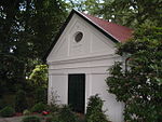
Liesbergmühle
The Liesbergmühle was built in 1756 as a ban mill, which is subject to mill compulsory, on behalf of Frederick the Great. It stands on a small hill 118 m above sea level. NN . The mill forms a monument ensemble with the engine house and a half-timbered cottage. In 1960 the mill ceased operations. The renovation began in November 2001 and was completed in September 2002.
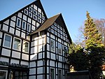
Church ring development
Remains of the former church ring development with half-timbered houses from the 18th century have been preserved in the town center. The eastern ring is particularly striking with a total of six houses built next to one another. The former Rosenbaum House (Widukind Museum) from 1716 and Kirchplatz 2 House (sun pharmacy) are located here. The latter was originally built in 1741, but demolished in 1969/70 due to disrepair. The massive new building that was built shortly afterwards was covered with the partially preserved wooden structure, so that at least the earlier appearance was preserved.
Enger Castle (historical) or Stracksches Haus
Enger Castle , which belonged to the noble lords of Lippe, stood in Enger until around 1305 . After a territorial dispute, it was razed. The castle stood on the corner of Burgstrasse and Mathildenstrasse, where Strack's house is today. The half-timbered house, built in 1664, is the oldest residential building in the city.
Sattelmeierhöfe

In Enger, as in other places of the former Sparenberg office of the County of Ravensberg, there were Sattelmeierhöfe. According to the legend, seven of these main courtyards go back to the faithfulness of Duke Wittekind. It was the special duty of the farm owners to be available to the sovereign for messenger services and to provide a saddled horse in case of war. The Sattelmeier were also obliged to accompany the sovereign on his visits to Ravensberg. In 2007 there were still five of these farms. The courtyards are in detail: Meyer-Johann in Oldinghausen, Ebmeyer in Oldinghausen, the Ringsthof and the Baringhof in Westerenger and the Nordhof on the western edge of the city center. The historic farmhouses have been preserved on many, impressive floorboard houses from the 18th and 19th centuries.
Monuments and fountains
Magpie bush monument
The Elsternbuschdenkmal was created in 1913 to commemorate the French occupation in 1813. The vernacular coined a Widukind legend. Widukind is said to have owned a bird hearth (observation post) in the Elsternbusch, a small wood that no longer exists. In medieval symbolism, the bird hearth in the figurative sense denotes the ruler's particular closeness to the people.
Widukind Monument
Only the base of the Widukind monument on the church square remains today. On August 7, 1903, it was inaugurated on the square in front of the collegiate church. The Saxon Duke Widukind was depicted, and the soldiers who fell in the Franco-Prussian War of 1870–1871 and those of the Austro-Prussian War of 1866 should be remembered. The memorial was erected at the instigation of the Warrior Association, the Landwehr and Reserve Association, the local authorities and the Protestant Church. In 1942 it was lifted from its pedestal without much resistance from the population of Engeran. The material was used for the production of weapons.
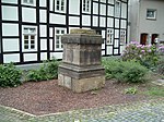
More monuments and fountains
- Widukindbrunnen on the Barmeierplatz
- Memorial stone to the Nazi victims on Heckewerthplatz
- POW memorial near the Widukind Museum, designed by Hermann Tödtmann, inaugurated on May 8, 1955 (ten years after the end of the war)
- Memorial for 408 fallen (from the area of the Enger office) of the First World War at the cemetery
- Mausoleum for the Nordmeier family, built in 1858, renovated in 1910
- Jewish cemetery on Ziegelstrasse; erected before 1892/96; the two years on the left gate pillar of the cemetery entrance (1892) and on the memorial plaque (1896) are not the founding years of the cemetery, according to an employee of the museum; "Closed" (last funeral) 1938

Magpie bush monument

Widukindbrunnen in Enger
Base of the former Widukind monument on the church square

Old view of the defunct Widukind monument

Memorial stone to the Nazi victims

Prisoner of War memorial near the Widukind Museum

Memorial to 408 fallen in the First World War
Mausoleum for the Nordmeier family

Tympanum of the south portal of the collegiate church in Enger
Old pharmacy


Parks and nature reserves


Enger has a central park, the so-called Maiwiese , which is bordered in the north by the Bolldammbach and in the south by the former small railway line. It can be accessed via Burgstrasse and Mühlenstrasse. From the historic city center, the Am Anger footpath leads from Steinstrasse directly to Maiwiese. There is a playground in the northeast.
Two nature reserves are located in the urban area of Engers. The approximately 22 hectare Asbeketal , which together with the Asbeke- / Kinzbachtal in the city of Herford, forms a natural spatial unit, has a sieve system typical of the Ravensberger Land and is home to a rich flora and fauna along the streams. The Enger Bruch am Bolldammbach , which is characterized by the open meadow landscapes , provides a habitat for a particularly large number of birds, including the lapwing , on 55 hectares . A total of around 77 hectares, or 1.87% of the urban area, are under nature protection.
Sports
The city sports association Enger is the coordinating body for the city's sports clubs. The sport of soccer is represented by the Rot-Weiß Dreyen gymnastics and sports association with three senior teams. The renovation of the sports facility in the Dreyen district was planned for 2007 (see there for details).
Other associations are:
- TV Concordia from 1864 Enger e. V .; founded in 1864; the club has over 1,500 members and offers badminton, popular sports, basketball, handball, judo, athletics, swimming, squash, tennis, gymnastics and volleyball. Since 1995, the association has maintained a children's sports school , in which different motor and sporting deficits of children aged five to nine are compensated for in four training levels. The office is located in the clubhouse on Freizeitweg, where the club's six tennis courts are located.
- SV Enger-Westerenger, football club; founded on April 16, 1993, has over 1,000 members. The club emerged from a merger of the clubs TSG Wittekind and TuS Westerenger.
- TuS Grün-Weiß Pödinghausen e. V .; The club offers badminton, children's gymnastics, walking, women's gymnastics and football (two men's teams, youth teams).
- TSV RW Dreyen 1913 eV; Football, gymnastics


- Table tennis club Enger, TTC Enger for short; founded on September 29, 1957; the club has several men's, women's and youth teams.
- Chess community Enger-Spenge, founded in 1947
- Schachclub Wittekinds Knappen e. V., founded in 2001
- Volleyball SG Schweicheln-Enger
- Model flying club "Libelle" Enger-Bünde e. V.
- Reiterverein Wittekind 02 Enger
- Association for gliding "Wittekind"
Other sports clubs in Enger are listed in the articles about the districts of Dreyen and Westerenger .
schools
- Städtische Realschule Enger: On August 30, 1994, the city council decided to set up a two-tier Realschule, just under a year later the association was founded.
- Rolf Dircksen School (Hauptschule): The Hauptschule and Realschule are located in a joint building complex on Ringstrasse (the Hauptschule has been closed since June 2016).
- Widukind-Gymnasium Enger on Tiefenbruchstrasse: Gymnasium with around 1000 students
- Four primary schools: Belke-Steinbeck (Humboldtstraße), Enger-Mitte (Poststraße), Oldinghausen / Pödinghausen (Schulstraße) and Westerenger (Holunderweg)
- Heideschule: Special school for people with learning disabilities in the Westerenger district on Holunderweg (closed since the end of the 2015/16 school year)
- Zweckverband Musikschule Enger / Spenge on Lehmkuhlenweg
- Adult Education Center on Bahnhofstrasse: The Herford District Adult Education Center is located with its Engeraner branch in the building of the city library. Before that there was a Progymnasium .
- Engers youth music school (since 1980) is located in the former customs office (1928–1962) in Kirchstrasse.
Regular events
- Timpkenfest : Every year on January 6th, after the service in the collegiate church, so-called Timpken - that is, quartered sweet rolls baked from white flour - are distributed. Legend has it thaton the day of his death, the Dukeof Saxony Widukind ordered the Timpken to support those in need. Nowadays, however, the timpken are distributed to all worshipers.
- Cherry Blossom Festival: Annual city festival in the city center on the last weekend in April. In 2008 it took place for the 30th time. The organizer is the Enger cultural and tourist association.
- Advent stroll : Every year on the first weekend in Advent from Friday to Sunday. Local groups and individual commercial vendors operate stands around the collegiate church. There is also a cultural program. The organizer is the Enger trade association.
- Kirmuli Children's Festival : Every two years there is a large, non-commercial children's festival in the Belke-Steinbeck district. In 2013 the children's rock band "Randale" performed on stage for the first time. In 2011, among other things, this resulted in the Wittekinds Kultur eV association.
Economy and Infrastructure
traffic
Road traffic
The connection to the city of Bünde , the city of Bielefeld and the A 30 motorway is via the L 557 state road (bypass). To the east, Herford Street / Enger Street (L 712) connects the town with Herford .
Rail and bus transport
The city of Enger has no connection to the railroad . The closest train stations are Bielefeld main train station and the train stations in Herford and Bünde . Formerly there were two small railway lines ( Herford small railway and Bielefelder Kreisbahnen ), but their operation has long been discontinued.
The following bus connections exist in RegioTakt :
- Line 54 to Bielefeld (connection with tram line 3 )
- Lines 465/466 to Herford
- Lines 464/465/466 to Spenge
- Line 654 to Bünde .
Enger belongs to the 'Westfalentarif' tariff association ( OWL Verkehr GmbH ).
Established businesses
The most important branch is the furniture industry with the nationally known companies RWK , Wellmann ( kitchen furniture ) and Puhlmann ( upholstered furniture ). The headquarters of the Alligator inking plants are located in Oldinghausen .
media
Two regional daily newspapers have their own editorial offices in the town of Enger. The Neue Westfälische appears six times a week with the local section Tageblatt for Enger and Spenge , the Herford Kreisblatt publishing house - which cooperates with the Westfalen-Blatt - publishes the Engerschen Anzeiger on weekdays . The advertising magazines City Talk and Blickpunkt also appear once a month .
Public facilities
Indoor garden pool Enger
The indoor garden pool Enger was built in the 1970s. After a renovation phase, it was reopened on June 29, 2006. It offers an indoor pool (25 by 10 meters) with a 1 and 3 meter tower. Outside there is an open-air pool with a slide, a toddler pool and the lawn for sunbathing.
Sports halls
Large sports hall Widukind-Gymnasium: 20 m by 45 m; Small sports hall at the Widukind grammar school: 15 m by 30 m
Evangelic Hospital
On January 19, 1873, the Enger Evangelical Hospital was opened on Hagenstrasse. Up until 1954, medical care was provided by general practitioners. Then it was expanded by 40 beds. The two medical areas internal medicine and surgery were also set up. In 1958, with the appointment of a full-time chief doctor, the change in the direction of a conventional hospital took place, which in the late 1960s and early 1970s, under the direction of Pastor Günther Körtner (1926-2015), the long-time chairman of the sponsoring association, added a nursing home for the elderly Nurses' home, a nursing school and a new operating theater area were expanded. In order to avert the threat of closure due to the changed economic situation, it was converted into a specialist clinic for geriatrics from 1991 . The specialist clinic for the treatment of old-age diseases has been run as a subsidiary of the Bünder Lukas Hospital since 1993.
Other public institutions
- City library on Bahnhofstrasse
- Youth and culture center Kleinbahnhof Enger, since November 5, 2002 with an internet café
- City of Enger Volunteer Fire Brigade ; five locations: Westerenger (founded: May 16, 1889), Enger (founded: November 20, 1875), Dreyen (founded on September 26, 1906 in the "Hermann Paust" restaurant), Besenkamp (founded: 1876) and Pödinghausen (founded : around 1912)
Telephone prefixes
In Enger the area code is 05224. Deviating from this, the area code in parts of Westerenger is 05225 and in parts of Besenkamp 05223.
Personalities
sons and daughters of the town
- Mathilde the Holy (895–968), wife of King Henry I
- Julius Vortriede (1820 to 1899), teacher, editor, newspaper publisher and democratic politician in the USA
- Wilhelm Müller (1875–1957), politician
- Heinrich Vedder (1876–1972), missionary
- Wilhelm Heiner (1902–1965), sculptor, painter and graphic artist
- Friedrich Hoepner (1889–1955), politician
- Wilhelm Husemann (1894–1956), cigar maker, politician, first mayor after the Second World War (1948–1956)
- Wolfgang Aßbrock (1952–2007), politician and member of the North Rhine-Westphalian state parliament (2005–2007)
- Wolfgang Meyer-Tormin (1911–1988), German clarinetist and composer
- Hans-Peter Riese (* 1941), art critic and political journalist, editor-in-chief at Hessischer Rundfunk
- Axel Horstmann (* 1954), economist and former minister. D.
- Norbert Sachser (* 1954), behavioral scientist
- Burkhard Zurheide (* 1958), politician
- Bernhard Lloyd (* 1960), bourgeois Bernd Gössling, keyboardist of the Waveband Alphaville
- Frank Mertens (* 1961), bourgeois Frank Sorgatz, keyboardist of the Waveband Alphaville
- Udo Nöger (* 1961), internationally known artist (painting), lives and works in Germany and the USA
Other personalities
- Widukind (around 730–807), Duke of Saxony; unclear, possibly legendarily decorated connection to Enger
- Hinrik Stavoer , sculptor, created the altar in the Engeraner collegiate church
- Simon I. zur Lippe (1261–1344), lord of the castle at Enger
- Hans Dammann (1867–1942), visual artist, created a monument in Enger
- Erich Kürschner (1911–1977), stage manager of the Hohnsteiner Puppenbühne , began his independent artistic activity in Enger.
- Peter Ostermeyer , chess master, played in Enger
- Werner Abelshauser (* 1944), renowned economic historian, lives in Enger
- Günther Körtner (1926–2015), pastor, from 1959 to 1993 chairman of the supporting association of the Ev. Hospital Enger
- Ulrich HJ Körtner (* 1957) Protestant theologian, grew up in Enger
- Karl-Heinz Wiesemann (* 1960), bishop, grew up in Enger
- Sigrid Evelyn Nikutta (* 1969), manager, grew up in Enger
- Klaus-Peter Nemet (* 1953) football and sports teacher, grew up in Enger and was active in the clubs TSG Wittekind Enger and TV Concordia Enger.
- Maik Walpurgis (* 1973) is a German football coach. In the 2016/2017 season he was the head coach of the Bundesliga club FC Ingolstadt 04, and from 2000 to 2002 he coached the SV Enger-Westerenger club, where he was promoted to the Westphalia Association in 2001.
- Ehrlich Brothers , Christian Ehrlich (* February 19, 1982 in Herford as Christian Reinelt), the younger brother of the show magician duo, lives in Enger
- Diego Demme , (born November 21, 1991 in Herford) is a German-Italian professional footballer. In his youth he played for SV Enger-Westerenger
- Friedrich Möllering alias Frittken vanne Hermannshöhe (1913–1996), Low German writer
literature
- Tighter. A home book for the millennium of the Widukindstadt, ed. from the city of Enger. C. Bertelsmann, Gütersloh 1948.
- Stefan Brakensiek (Ed.): Widukind. Research on a Myth . Publishing house for regional history, Bielefeld 1997, ISBN 3-89534-198-3 .
- Rudolf Härting, Günther Körtner: To Widukind's memory. Part I: From the history of the Wittekindsspende and the Timkenfest in Enger by Rudolf Härting. Part II: About Widukind's Age - Attempt at a Brief Overview - by Günther Körtner . Published by the Ev.-luth. Parish Enger, Enger 1980
- Leopold Schütte: City folder Enger. (= Westphalian city atlas. Volume II, 6 parts). Dortmund-Altenbeken 1988, ISBN 3-89115-348-1 .
- Widukindstadt Enger. Festschrift for the school inauguration and naming on May 12, 1973, ed. from the city of Enger. Special print. Narrow 1973.
- Gustav Engel: village, city and office Enger. Enger 1981, DNB 881334693 . (Abridged, supplemented and in several parts corrected reprint from Enger - a home book for the millennium of the Widukindstadt. 1948, OCLC 832484721. )
- Wolfgang Balz: Closer as it was. Bielefeld 1983, ISBN 3-88918-008-6 .
- Regine Bürk-Griese, Regine Krull, Martina Sünder-Gass: Collegiate Church Enger. Ed. Ev. Luth. Parish Enger, year not specified (after 1994).
- Heinrich Niemöller : Enger, the Wittekindstadt, in legend and history. Bielefeld 1927, DNB 361953992 .
Web links
- Website of the city of Enger
- private website about Enger
- Closer in the Westphalia culture atlas
Individual evidence
- ↑ Population of the municipalities of North Rhine-Westphalia on December 31, 2019 - update of the population based on the census of May 9, 2011. State Office for Information and Technology North Rhine-Westphalia (IT.NRW), accessed on June 17, 2020 . ( Help on this )
- ^ PM Ministry of the Interior
- ↑ Birgit Meineke: The place names of the Herford district. Westphalian Place Name Book (WOB). Publishing house for regional history, Gütersloh 2011, p. 94
- ↑ Bolldammbach
- ↑ Enger Bruch nature reserve ( memento from November 30, 2003 in the Internet Archive )
- ↑ Geological Service NRW: Using geothermal energy - Geothermal study provides planning basis ( Memento from September 14, 2005 in the Internet Archive ) (PDF; 369 kB)
- ^ A b State Office for Data Processing and Statistics North Rhine-Westphalia: Municipal profile of the city of Enger. (PDF) it.nrw, April 24, 2019, accessed June 10, 2019 .
- ^ Main statute of the city of Enger from November 9, 2004 ( Memento from October 14, 2007 in the Internet Archive ), PDF
- ↑ a b City of Enger: Numbers, data, facts ( Memento of October 12, 2007 in the Internet Archive ), as of December 31, 2007.
- ↑ a b Enger - collegiate church
- ^ Enger Collegiate Church. Brochure of the Ev. Luth. Parish Enger, p. 27 (building history)
- ↑ Gustav Engel: Village, City and Office Enger. Enger 1981, pp. 27f.
- ↑ Enger - tower of the church
- ↑ Widukind Museum Enger
- ↑ Martin Bünermann: The communities of the first reorganization program in North Rhine-Westphalia . Deutscher Gemeindeverlag, Cologne 1970, p. 74 .
- ^ Wilhelm Weitz: From the Saxon people's leader Widukind and the cult site Enger. A brief introduction to the militant past of the Widukindland, understandable for all German national comrades. Published by the city of Enger in Westphalia. Enger, Bielefeld 1938.
- ↑ a b Martin Bünermann, Heinz Köstering: The communities and districts after the local government reform in North Rhine-Westphalia . Deutscher Gemeindeverlag, Cologne 1975, ISBN 3-555-30092-X , p. 102 .
- ↑ Detmold district government: Pupils at general education schools in North Rhine-Westphalia according to religious affiliation ( Memento of October 3, 2006 in the Internet Archive ), PDF, as of 2002/03
- ↑ State database NRW; Election results for the municipality code 05758008
- ^ State Office for Information and Technology in North Rhine-Westphalia: Local elections
- ^ The State Returning Officer NRW
- ↑ Local election results Enger 2014
- ↑ Mayor direct election on September 12 and 26, 1999 in Enger ( Memento of November 27, 2007 in the Internet Archive )
- ^ The mayor of the city Enger, main administrative officer and representative of the city ( Memento of March 8, 2005 in the Internet Archive )
- ↑ Thomas Meyer is the new mayor. In: New Westphalian. 13th September 2015.
- ↑ Main statute of the city of Enger ( Memento of October 14, 2007 in the Internet Archive ) (PDF; 29 kB)
- ↑ Description of the coat of arms
- ↑ Lichtensteinplatz - A piece of Lichtenstein in the middle of Enger. Retrieved July 28, 2014 .
- ^ Museum website. gerbereimuseum.de, accessed on June 22, 2019 .
- ↑ narrower.de
- ↑ Neues Forum Enger eV - News. Retrieved July 28, 2014 .
- ↑ Teutoburg Forest holiday region
- ^ Personal visit by Norbert Bangert on November 9, 2008 on the occasion of a guided tour
- ↑ Nature reserves in the Herford district
- ↑ The last day of the Rolf Dircksen School, article in the "Neue Westfälische", as of June 21, 2016, 6:46 pm
- ↑ Our school introduces itself | Widukind Gymnasium Enger. Retrieved August 18, 2020 .
- ↑ The end of the Heideschule - Enger-Spenge Förderschulverband decides: The facility will be closed in mid-2016 , Neue Westfälische from February 19, 2015, accessed on January 9, 2018
- ↑ Perspectives for the Heideschüler - special needs school in Westerenge expires in summer , Neue Westfälische from February 25, 2016, accessed on January 9, 2018
- ↑ City presents usage concept for the former Heideschule - associations should move in , Westfalen-Blatt dated January 13, 2017, accessed on January 9, 2018
- ↑ Westfalen-Blatt: Homepage
- ↑ On the history of the Engeraner hospital: "From the infirmary to the geriatric hospital" ( Memento from May 20, 2008 in the Internet Archive )
- ↑ a b kirchenkreis-herford.de ( Memento from October 25, 2015 in the Internet Archive )
- ^ Website of the volunteer fire brigade
Belke-Steinbeck | Besenkamp | Dreyen | Narrower | Herringhausen | Oldinghausen | Pödinghausen | Siele | Westerenger
Frets | Narrower | Herford | Hiddenhausen | Kirchlengern | Wages | Rödinghausen | Spenge | Vlotho