Gehlenbeck
|
Gehlenbeck
City of Luebbecke
Coordinates: 52 ° 18 ′ 37 ″ N , 8 ° 38 ′ 54 ″ E
|
|
|---|---|
| Height : | 50–288 m above sea level NN |
| Area : | 11.13 km² |
| Residents : | 3310 (Dec. 31, 2007) |
| Population density : | 297 inhabitants / km² |
| Incorporation : | 1st January 1973 |
| Postal code : | 32312 |
| Area code : | 05741 |
|
Location of Gehlenbeck in Lübbecke
|
|
Gehlenbeck is a district of the East Westphalian town of Lübbecke in the Minden-Lübbecke district . The former cluster village is now the second largest district in terms of inhabitants. A stream flows through the district, the "Gehle Beke" (High German: "yellow stream"), which was once the namesake for the village. The district is around 11 km². With 297 inhabitants per km², Gehlenbeck is slightly less densely populated than the entire city of Lübbecke (398 inhabitants / km²). The comparatively low population density is mainly due to the fact that a very large section of the Great Peat Bog was added to the district.
geography
Geographical location
Gehlenbeck is located on the northern slope of the Wiehengebirge , at the foot of the Gehlenbeck mountain . To the west it borders on the core town of Lübbecke and to the east on the district of Eilhausen . To the north of Gehlenbeck are the Mittelland Canal and the Great Peat Bog . The federal highway 65 runs directly through the place. Gehlenbeck has a share in all three major landscapes of the entire city of Lübbecke:
- In the south part of the Wiehengebirge
- The center naturally belongs to the Lübbecker Loessland
- The north in turn is part of the Rahden-Diepenauer Geest , with Gehlenbeck a large part of the "Lübbeck part" of the large peat bog belongs to.

history
In Gehlenbeck there must have been a church as early as the 10th century, as has been proven by excavations. A church was not mentioned in a document until 1156. The people in Gehlenbeck lived with and from agriculture over the centuries. In the 19th century, many people from Gehlenbeck found work in the cigar industry. Due to the close development, large parts of the village burned down in 1766 and 1865. In 1867, an area of 346 hectares was made available to form the new municipality of Eilhausen . Until the regional reform , which came into effect on January 1, 1973, Gehlenbeck was an independent municipality in the Gehlenbeck district in the Lübbecke district . Then it was incorporated into the city of Lübbecke.
Culture and sights
St. Nicholas Church
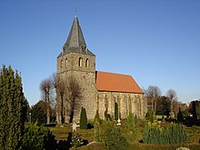
Today's Gehlenbeck Church was built around 1495 and consecrated to St. Nicholas. A stone plaque attached to the sacristy says in German translation: "In the year of the Lord 1495 this building was erected on the feast of Maria Magdalena in honor of St. Nicholas." St. Nicholas can still be seen in the Gehlenbeck church seal today. He holds a staff with a double cross in his hand as a sign of his episcopal dignity. The tower of the Gehlenbeck church is much older and was probably built between 1100 and 1150. However, this could not be precisely proven. The St. Nicholas Church is the core of the Protestant parish of Gehlenbeck.
Gehrmker Hius
The new Gehlenbeck Heimathaus (in Plattdt. "Gehrmker Hius"), located on the B 65 (Lindenstrasse), has recently offered an insight into village life in the past. The Gehrmker Hius is the half-timbered farmhouse of Marie Röthemeier, who died in 1998, formerly Hof Wellpott No. 17. The listed building was inaugurated after extensive renovation work on July 10, 2004 in a festive ceremony followed by a village festival.
Gut Renkhausen
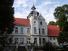
The Good Renkhausen is a mansion close to the Midland Canal . It was originally in the 18th century on the walls of an old water castle built in half-timbered construction. In 1896 the estate was converted into a villa-like mansion in the Neo-Renaissance style. In addition to the agricultural use, you can get civil weddings in the rooms and use the festive rooms for parties. The “café in the small stall” is used as a starting point for bike tours in the large peat bog or on the Mittelland Canal.
Sports
The TuS Gehlenbeck is the largest membership sports club in the local composite Gehlenbeck / Eilhausen with a well-developed youth work. This club has expanded its range of sports and was founded in 1945.
Others
There is an outdoor swimming pool in Gehlenbeck , the only one in the city of Lübbecke since 2005. From 1973 to 2005 the city had two outdoor pools: the official outdoor pool in Gehlenbeck and the outdoor pool in Lübbeck's core city. This was the direct consequence of the regional reform and the dissolution of the Gehlenbeck office. The Gehlenbeck public pool, which was once centrally located in the middle of the Gehlenbeck office, just south of the Mittelland Canal, fell to the city of Lübbecke, although Lübbecke already had a municipal free band in the core city. Now Lübbecke had to finance two outdoor pools. After decades of discussion, the old inner-city open-air pool in a central location was abandoned in 2005 after a referendum in which Gehlenbeck was able to mobilize more citizens, and the very remote Gehlenbeck open-air pool became Lübbeck's only public open-air pool.
Individual evidence
- ↑ Werner Fabis, GEHLENBECK A village in the mirror of history, page 28
- ↑ Werner Fabis, GEHLENBECK A village in the mirror of history, pages 409–446
- ↑ Werner Fabis, GEHLENBECK A village in the mirror of history, pp. 370–387
- ↑ Stephanie Reekers: The regional development of the districts and communities of Westphalia 1817-1967 . Aschendorff, Münster Westfalen 1977, ISBN 3-402-05875-8 , p. 235 .
- ^ Federal Statistical Office (ed.): Historical municipality directory for the Federal Republic of Germany. Name, border and key number changes in municipalities, counties and administrative districts from May 27, 1970 to December 31, 1982 . W. Kohlhammer, Stuttgart / Mainz 1983, ISBN 3-17-003263-1 , p. 325 .
literature
- Werner Fabis: Gehlenbeck - A village in the mirror of history . Publisher: Heimatverein Gehlenbeck e. V.
Web links
- Internet presence of the city of Lübbecke
- Gehrmker Hius - Heimathaus Gehlenbeck
- Gehlenbeck in the Westphalia Culture Atlas


