Eilhausen (Luebbecke)
|
Eilhausen (Luebbecke)
City of Luebbecke
Coordinates: 52 ° 18 ′ 37 ″ N , 8 ° 39 ′ 50 ″ E
|
|
|---|---|
| Height : | 50–288 m above sea level NN |
| Area : | 3.5 km² |
| Residents : | 764 (Dec. 31, 2007) |
| Population density : | 218 inhabitants / km² |
| Incorporation : | 1st January 1973 |
| Postal code : | 32312 |
| Area code : | 05741 |
|
Location of Eilhausen (Lübbecke) in Lübbecke
|
|
Eilhausen is a district of Lübbecke in the Minden-Lübbecke district in East Westphalia . Eilhausen is the smallest district of the city of Lübbecke in terms of population. It was assigned to Gehlenbeck until 1867 and then until 1973 an independent municipality within the Gehlenbeck office. The place is on the north side of the Wiehengebirge and is cut through by the B 65. The large peat bog spreads out in the immediate vicinity of the arable land in the north.
geography
Geographical location
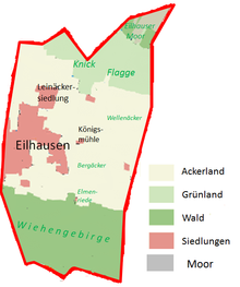
Eilhausen is on the northern slope of the Wiehengebirge . The district area is unusually narrow, with a large north-south expansion. To the west it borders on the Gehlenbeck district and to the east on the Nettelstedt district . To the north of Eilhausen lies the Great Peat Bog . The federal highway 65 runs directly through the place. The district is only 3.5 km². Nevertheless, Eilhausen has a share in all three major landscapes of the entire city of Lübbecke:
- In the south part of the Wiehengebirge
- The center naturally belongs to the Lübbecker Loessland
- The north, in turn, is part of the Rahden-Diepenauer Geest , with Eilhausen having a part of the "Luebbeck part" of the Great Peat Bog, albeit a very small one.
The natural environment of Eilhausen is very similar to that of the two neighboring villages Nettelstedt and Gehlenbeck. In the south the actual village borders on the Wiehengebirge and in the north the low-lying grassland merges into the nature reserve of the large peat bog. In between, on the fertile loess strip, lies the relatively closed village, which however has no center of its own. The two landmarks of Eilhausen, the Königsmühle in the field east of the village and the watermill on the Dorfbach Elmenriede in the village center, bear witness to the earlier importance of agriculture.
With 219 inhabitants per km², Eilhausen is significantly less densely populated than the entire city of Lübbecke (400 inhabitants / km²). The population is not evenly distributed, however, but is concentrated in the central part, more or less the area of the Lübbecker Loessland. The Wiehengebirge, on the other hand, is uninhabited and the north is not or only marginally populated.
history
Eilhausen is first mentioned in a document in 1300. A map of the farmers made around 1800 shows the farms of Gerdom, Schütte, Rathmann, Oberste and Niederste Selle, the mills that can still be found today: a water mill and a wind mill. In 1867, the Eilhausen community was reorganized by hiving off the Gehlenbeck community . Until the municipal reorganization on January 1, 1973, Eilhausen was an independent municipality in the Gehlenbeck district of the Lübbecke district .
Local awareness
In contrast to the two neighboring villages, Eilhausen does not have much independence and was inevitably related to the larger neighboring village of Gehlenbeck in terms of church and school. However, this did not mean that there was a limited Eilhauser self-confidence. Although the settlement areas of Eilhausen and Gehlenbeck merge today and borders are no longer recognizable, the people of Eilhausen know very well who belongs to Eilhausen and who does not.
Culture and sights
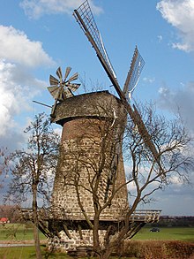
With the "Holländer Windmühle" and the watermill, the village of Eilhausen contributes to the Westphalian Mill Road with two mills .
"Königsmühle"
The restored Eilhauser windmill belongs to the type of "Dutch Windmill" (taken over from Holland), which found widespread use in northern Germany in the 18th century. With this type of mill, the hood turns and not the whole mill as with the post mill.
Watermill
The small single-storey quarry stone building with half-timbered gables could have been built in 1698 according to a carved date.
Sports
- An active shooting club is located in Eilhausen. The members maintain a good relationship with the population. The shooting range in the Wiehengebirge has a modern air rifle shooting range and attractive common rooms
- TuS Gehlenbeck is the sports club with the largest number of members in the Gehlenbeck / Eilhausen community.
Individual evidence
- ↑ Stephanie Reekers: The regional development of the districts and communities of Westphalia 1817-1967 . Aschendorff, Münster Westfalen 1977, ISBN 3-402-05875-8 , p. 230 .
- ^ Federal Statistical Office (ed.): Historical municipality directory for the Federal Republic of Germany. Name, border and key number changes in municipalities, counties and administrative districts from May 27, 1970 to December 31, 1982 . W. Kohlhammer, Stuttgart / Mainz 1983, ISBN 3-17-003263-1 , p. 325 .
Web links
- Website of the superordinate city of Lübbecke
- Eilhausen in the Westphalia Culture Atlas


