Blasheim
|
Blasheim
City of Luebbecke
Coordinates: 52 ° 18 ′ 10 ″ N , 8 ° 33 ′ 58 ″ E
|
|
|---|---|
| Height : | 59 m |
| Area : | 6.07 km² |
| Residents : | 1473 (Dec. 31, 2007) |
| Population density : | 243 inhabitants / km² |
| Incorporation : | 1st January 1973 |
| Postal code : | 32312 |
| Area code : | 05741 |
|
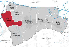
Location of Blasheim in Lübbecke
|
|
Blasheim is a district of the East Westphalian city of Lübbecke in the Minden-Lübbecke district in North Rhine-Westphalia .
geography
The south of Blasheim is naturally located in the Lübbecker Loessland . This sub-area is characterized by a slope towards the Wiehengebirge, which is hardly noticeable here, and a fertile layer of loess. The middle and the north are already part of the Rahden-Diepenauer Geest. The district is bordered by the Lübeck districts of Alswede and Stockhausen in the north, the Lübbeck core city in the west and the Obermehnen district in the south . The western border of Blasheim represents the outer border between the city of Lübbecke and the city of Preußisch Oldendorf . The area of the old community of Blasheim was 21.38 km². After the spin-off farming communities Obermehnen and Stockhausen and their elevation to discrete parts of the current district Blasheim is plentiful 6 square kilometers. This means a population density of around 245 inhabitants per km². In the entire city of Lübbecke, an average of 400 inhabitants live on one km². Apart from traffic and building land, the area of the district is mainly used for agriculture. In the south and in the center arable land dominates. In the north, grassland takes up a larger proportion of the area. Larger forest areas are missing. In the northwest, however, the area borders directly on the Hollwinkeler Holz . Of this, however, only a negligible part in the south of only around 0.58 hectares belongs to the Blasheim district. The most important rivers include the Große Aue , which grazes the district area in the northwest, the Mehner Bach , which flows through the town center, and the Flöthe in the east.
history
Blasheim is mentioned for the first time in a document from Minden Bishop Milo (969–996), along with seven other courts. The place name of Blasheim has changed: from Blesnon 969, about Blassum 1244 Blasne 1332 and Pale 1493. The name is probably connected with blaze (= bright spot). Blasheim then means something like settlement in a forest clearing.
As in other districts of Lübbeck, in Blasheim there is evidence of manorial property of the Counts of Tecklenburg , who owned the region in the Middle Ages. They are also considered to be the founders of the Marienkirche Blasheim , the construction of which was completed in 1514.
In 1491 was by the Minden Bishop Heinrich von Schauenburg the Sprengel Blasheim, together with the peasantry Stockhausen , Eikel , Obermehnen and Knöttinghausen the full parochial rights awarded.
The Blasheimer Markt emerged from the festival dedicated to the consecration of St. Mary's Church, and is particularly popular in the early September days, as the birth of Mary is celebrated at this time .
From 1843 to 1890 the municipality of Blasheim formed its own office , which was co-administered by the Oldendorf office in personal union.
In 1910, the Marienkirche in Blasheim was extended by a south aisle and was restored. The late Gothic apostle altar of the church is worth seeing today . For centuries, Blasheim formed a political unit with the farming communities of Obermehnen in the south and Stockhausen in the north, then on January 1, 1973 the formerly much larger community of Blasheim was incorporated into the city of Lübbecke.
The current district of Blasheim only covers a third of the area of the old community, as a large part of the community area went to the districts of Obermehnen and Stockhausen. In addition, Blasheim, and indirectly the entire city of Lübbecke, lost some areas: the former municipality of Blasheim was largely annexed to Lübbecke, but without a strip of around 100 hectares with the places Blasheimer Busch and Knötinghausen as well as plenty of agricultural land, fell to the city of Preussisch Oldendorf. Blasheim continues to fulfill certain central functions for the districts of Stockhausen and Obermehnen, here in particular for the "Unterortteil" Untermehnen , in terms of infrastructure. Examples are the area of the parish with church, parish hall and cemetery, the elementary school and the kindergarten.
politics
- The mayor of Blasheim is Manfred Muth.
- The local caretaker is Walter Hoffmann.
(As of July 2008)
Sports
In Blasheim there is the gymnastics and football club BSC Blasheim 1894 eV with a men's and a women's team.
Individual evidence
- ↑ Blasheim community (ed.): 1000 years Blasheim community. Blasheim, Minden 1969, p. 11f.
- ^ Wolfgang Leesch: Administration in Westphalia 1815-1945 . In: Publications of the Historical Commission for Westphalia . tape 38 . Aschendorff, Münster 1992, ISBN 3-402-06845-1 .
- ^ Official Journal of the Minden Government 1843: Formation of the offices in the Lübbecke district
- ^ Federal Statistical Office (ed.): Historical municipality directory for the Federal Republic of Germany. Name, border and key number changes in municipalities, counties and administrative districts from May 27, 1970 to December 31, 1982 . W. Kohlhammer, Stuttgart / Mainz 1983, ISBN 3-17-003263-1 , p. 325 .
Web links
- Website of the superordinate city of Lübbecke
- Blasheim in the Westphalia Culture Atlas


