
Lübbecke district
| coat of arms | Germany map |
|---|---|

|

Coordinates: 52 ° 18 ' N , 8 ° 37' E |
| Basic data (as of 1972) | |
| Existing period: | 1816-1972 |
| State : | North Rhine-Westphalia |
| Administrative region : | Detmold |
| Regional association : | Westphalia-Lippe |
| Administrative headquarters : | Luebbecke |
| Area : | 564.8 km 2 |
| Residents: | 93,000 (Dec. 31, 1971) |
| Population density : | 165 inhabitants per km 2 |
| License plate : | LK |
| Circle key : | 05 7 38 |
| Circle structure: | 50 parishes |
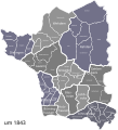
| Location of the Lübbecke district in North Rhine-Westphalia | |
  |
|
The Lübbecke district (1939–1969: Lübbecke district ) was a district in East Westphalia that existed from 1832 to 1972 . Its forerunner was the Rahden district . The district was in the administrative district of Minden in the Prussian province of Westphalia , from 1947 in the administrative district of Detmold in North Rhine-Westphalia . Its administrative seat was Lübbecke . The district went up in 1973 as part of the North Rhine-Westphalian territorial reform in the newly founded Minden-Lübbecke district . An unofficial name has been Altkreis Lübbecke since 1973 .
geography
location


The Lübbecke district was located in the northeast of North Rhine-Westphalia and in the north of East Westphalia-Lippe . Its area was mostly in the North German Plain and reached in the south to the Wiehen Mountains . South of the Wiehengebirge, the district had a share in the Ravensberg hill country from 1832 . The Stemweder Berg is located in the far northwest of the former district area . The low plains portion of the former district can be divided into the Lübbecker Lößland as a narrow border of fertile soil along the Wiehengebirge, and the Rahden-Diepenauer Geest further north. To the east of the district is the large peat bog .

The Mittellandkanal severed in 1915 the county in east-west direction, until the 1960s, the portion south of the canal more industrial, the part was north of it dominated agriculture as rather. Most of the area is drained by the catchment area of the Große Aue and its tributaries, the Kleine Aue and the Großer Dieckrivers, northwards to the Weser . Peripheral areas belong to the catchment area of the Bastau , the Hunte and the Werre . Due to its geographical shape and the heavy agricultural use, the northern part was also known as the “green crown of Westphalia”. The so -called North Rhine-Westphalia point , the northernmost point of the state, lies in the area of the district .
Until the 1960s, the part south of the canal was considered more industrial, while the part north of it was more dominated by agriculture. The three northern municipalities of Stemwede, Rahden and Espelkamp are commonly referred to as the northern district. The connecting bracket is the even more pronounced integration with Lower Saxony and also the comparatively lower population density.
Adjacent areas
The district initially bordered the Kingdom of Hanover in the west and north , and since 1946 on Lower Saxony (districts of Melle and Wittlage (later: district of Osnabrück ) (west), district of Grafschaft Diepholz (north), district of Nienburg / Weser (northeast)). To the east was the district of Minden . In the south, the Lübbecke district bordered on the Herford district from 1832 (until 1831 on the then dissolved Bünde district ).
history
Assignment to higher regional authorities
_beschriftet_Luebbecke.svg)
|

|
|
|
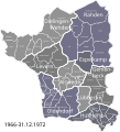
Location of the district in the administrative district of Minden 1832–1947 and the administrative district of Detmold 1947–1968
|
||
The district area belonged to the Prussian administrative area Minden-Ravensberg until 1806 . The northern and eastern part of the later district belonged to the Principality of Minden (Rahden Office and most of the Reineberg Office and the city of Lübbecke) and the southwestern part belonged to the Ravensberg County (northern part of the Limberg Office), both of which from 1648 belonged to Brandenburg-Prussia belonged.
In the Peace of Tilsit the area was separated from Prussia and assigned to the French-ruled Kingdom of Westphalia between 1807 and 1810 ( Weser department , Minden district ). Between 1811 and 1813 the area was annexed by the French Empire ( Ober-Ems department , Minden district). The area received an administration based on the French model and was divided into several cantons. After the reconquest by Prussia, it was provisionally part of the civil government between the Weser and the Rhine from 1813 until the founding of the Prussian province of Westphalia .
Administrative history

After the reorganization by the Congress of Vienna , the district of Rahden was founded in 1816 by a Prussian administrative reform with the seat of the district administration in Rahden in the administrative district of Minden in the province of Westphalia . The circle was also called mayors or cantons designated ten counties Alswede, Blasheim, Börninghausen, Dielingen, Holzhausen, Levern, Lübbecke, Oldendorf, Rahden and Wehdem divided whose borders largely oriented on the eleven parishes of the circle:
On January 1, 1832, the area of the parishes of Hüllhorst (localities Ahlsen with Reineberg , Büttendorf , Hüllhorst ) and Schnathorst (localities Bröderhausen , Holsen , Schnathorst , Tengern ) as well as the village of Oberbauerschaft belonging to the parish of Lübbecke from the dissolved Bünde district were incorporated into the district . At the same time Lübbecke district town and the district was renamed accordingly. Adolf von der Horst held the office of district administrator until 1870 von der Ellerburg . The Lübbecke district is now divided into eight administrative districts with two cities and 46 other localities:
| Rahden district (1821) | District of Lübbecke (1833) | ||
|---|---|---|---|
| Administrative district 1 |
Parish | Municipalities 2 | Communities |
| Luebbecke | Luebbecke 4 | Lübbecke (city) | Ahlsen with Reineberg, Blasheim, Bröderhausen, Büttendorf, Frotheim, Gehlenbeck, Holsen, Hüllhorst, Isenstedt, Lübbecke (city), Nettelstedt, Oberbauerschaft, Obermehnen , Schnathorst, Stockhausen, Tengern |
| Gehlenbeck | Gehlenbeck, Nettelstedt, Isenstedt, Frotheim | ||
| Blasheim | Blasheim | Blasheim, Obermehnen, Stockhausen | |
| Alswede | Alswede | Alswede, Fabbenstedt, Hedem, Lashorst, Vehlage | Alswede, Fabbenstedt, Hedem, Lashorst, Vehlage |
| Holzhausen | Holzhausen | Heddinghausen, Holzhausen | Heddinghausen, Holzhausen |
| Borninghausen | Borninghausen | Börninghausen, Eininghausen | |
| Oldendorf | Oldendorf | Engershausen, Getmold, Harlinghausen, Oldendorf (city), Offelten, Schröttinghausen | Börninghausen, Eininghausen, Engershausen, Getmold, Harlinghausen, Offelten, Oldendorf (city), Schröttinghausen |
| Rahden | Rahden | Großendorf with Rahden, Kleinendorf, Ströhen, Varl, Wehe | Großendorf with Rahden, Kleinendorf, Ströhen, Varl, Wehe |
| Levern | Levern | Destel, Levern, Niedermehnen, Sundern | Destel, Levern, Niedermehnen, Sundern |
| Dielingen | Dielingen 3 | Arrenkamp, Dielingen, drone, Haldem | Arrenkamp, Dielingen, drone, Haldem |
| Woe | Woe | Oppendorf, Oppenwehe, Wehdem, Westrup | Oppendorf, Oppenwehe, Wehdem, Westrup |
1 Sometimes also referred to as cantons or mayorships
2 Often referred to as farmers' associations
3 In addition, the village of Stemshorn still belongs to the parish of Dielingen, which, however, politically belonged to the Kingdom of Hanover and is now part of Lower Saxony .
4 The village of Oberbauerschaft in the district of Bünde also belonged to the parish of Lübbecke .
As part of the introduction of the rural community order for the province of Westphalia in 1843, the district was divided into eleven offices . The city of Lübbecke remained vacant. The establishment of the offices was based on the existing administrative districts and parishes. At the same time, all places that had their own household for their communal needs were given the status of a (rural) commune. Places in the district of Lübbecke that were not given municipal status in this context, but were assigned to larger municipalities, included Eininghausen, Heddinghausen, Obermehnen and Stockhausen. In addition to the municipalities, five manor districts were also set up in the Lübbecke district . On January 1, 1849, Sielhorst was separated from Varl and formed another community in the Rahden district. In 1850, the district of Lübbecke was divided into the city of Lübbecke, which was free of charge, as well as 44 municipalities and five manor districts in eleven offices.
The two offices of Dielingen and Wehdem, established in 1843, were administered in personal union by the Dielingen bailiff right from the start, and in the 1860s they were also formally merged into one office based in Dielingen. In 1936 the office was renamed Amt Dielingen-Wehdem .
The offices of Blasheim, Börninghausen and Holzhausen have been jointly administered by the bailiff of the Oldendorf office since 1843. In 1890 they were also formally incorporated into the Oldendorf Office. The Office Schnathorst was renamed to Office Hüllhorst between 1866 and 1871 .

On May 1, 1858, Tonheide was separated from Wehe and formed a community in the Rahden district. In 1867, the municipality Eilhausen was formed in the Gehlenbeck office by hiving off from Gehlenbeck.
Oldendorf adopted the rural community order and was run as a titular town in the 19th century (as a patch in 1871). In 1905 Oldendorf was given the addition of "Prussian" to its name, and around 1910 also the municipality of Ströhen. In 1909 Huchzen was formed by outsourcing from Tengern to the Hüllhorst office. On April 1, 1910, Großendorf was divided into the two communities Espelkamp and Rahden . The five manor districts were dissolved on September 30, 1928. Benkhausen and Ellerburg were incorporated into the municipality of Alswede, Hollwinkel into the municipality of Hedem, Hüffe into the municipality of Lashorst and the manor district of Haldem into the municipality of the same name. On April 1, 1936, the municipality Twiehausen was formed in the Levern district by hiving off from Destel.
The Lübbecke district was a stronghold of the National Socialists. In the Reichstag election on July 31, 1932, the NSDAP achieved a share of the vote of over 60%. Espelkamp developed relatively rapidly from around 1938. The foundation stone for this development was formed by the establishment of the Lübbecke Army Munitions Plant in 1938/1939. On April 4, 1945, English and Canadian troops reached the district. This ended the war in the district. The area was completely in the British zone of occupation after the war . The British occupiers initially had their headquarters in Bad Oeynhausen and therefore stayed in the district town of Lübbecke for a long time.
From 1939 to 1969 the district was called "Landkreis Lübbecke". In 1946 the administrative district of Minden and thus the district of Lübbecke became part of the new state of North Rhine-Westphalia. With the accession of the state of Lippe to the state of North Rhine-Westphalia in 1947 (formally completed in 1948), the administrative district of Minden was enlarged to include the Lippe areas in 1947. The district now called the Detmold administrative district after the new administrative center (briefly and initially referred to as the Minden-Lippe district) belonged to the Lübbecke district until it was dissolved.
Espelkamp continued on his way to the third town in the Lübbecke district after the war and the end of the munitions factory, as many expellees were quartered in the barracks of the munitions factory, which were initially empty . Espelkamp received city rights in 1959 and became vacant in 1966.
From October 1, 1969, the Lübbecke district was again called the Lübbecke district.
The Lübbecke district was last (1972) divided into two cities without an office and 48 municipalities in seven offices.

1816: Rahden district (dashed lines: borderline not exactly known)

1832: incorporation of the upper peasantry and the parishes of Hüllhorst and Schnathorst
1843: offices are established

until 1858: reduction in the number of offices

Division after the spin-off of Twiehausen (1936)
1966: Espelkamp becomes a city without an office


| Office | Municipalities and manor districts 1850 | Municipalities 1972 |
|---|---|---|
| city free of charge | Luebbecke | Espelkamp, Luebbecke |
| Gehlenbeck | Frotheim, Gehlenbeck, Isenstedt, Nettelstedt | Eilhausen , Frotheim , Gehlenbeck , Isenstedt , Nettelstedt |
| Schnathorst, from 1849: Hüllhorst | Ahlsen-Reineberg, Bröderhausen, Büttendorf, Holsen, Hüllhorst, Oberbauerschaft, Schnathorst, Tengern | Ahlsen-Reineberg , Bröderhausen , Büttendorf , Holsen , Huchzen , Hüllhorst , Oberbauerschaft , Schnathorst , Tengern |
| Alswede | Alswede, manor district Benkhausen , manor district Ellerburg , Fabbenstedt, Hedem, manor district Hollwinkel , manor district Hüffe , Lashorst, Vehlage | Alswede , Fabbenstedt , Hedem , Lashorst , Vehlage |
| Blasheim (until 1890) | Blasheim | |
| Börninghausen (until 1890) | Borninghausen | |
| Holzhausen (until 1890) | Holzhausen | |
| Oldendorf | Engershausen, Getmold, Harlinghausen, Oldendorf, Offelten, Schröttinghausen | Blasheim , Börninghausen , Engershausen , Getmold , Harlinghausen , Holzhausen , Offelten , Preußisch Oldendorf (town), Schröttinghausen |
| Rahden | Großendorf, Kleinendorf, Sielhorst, Ströhen, Varl, Wehe | Kleinendorf , Preußisch Ströhen , Rahden , Sielhorst , Ton Heide , Varl , Wehe |
| Levern | Destel, Levern, Niedermehnen, Sundern | Destel , Levern , Niedermehnen , Sundern , Twiehausen |
| Dielingen (until 1936) | Arrenkamp, Dielingen, drone, Haldem, Haldem manor district | |
| Woe (until 1936) | Oppendorf, Oppenwehe, Wehdem, Westrup | |
| Dielingen-Wehdem | Arrenkamp , Dielingen , drone , Haldem , Oppendorf , Oppenwehe , Wehdem , Westrup |
Measures and plans in the course of the regional reform
New cutting of the district area
As part of the North Rhine-Westphalian regional reorganization of companies in the wake of the reaction was "(Law for the restructuring of municipalities and districts of the reorganization room Bielefeld of the Bielefeld-law )" on 1 January 1973 with the Minden for Minden-Lübbecke combined. The amalgamation of the towns and municipalities of the district to the six towns and municipalities Espelkamp , Hüllhorst , Lübbecke , Preußisch Oldendorf , Rahden and Stemwede was also determined by this law .
The amalgamation with the district of Minden was fiercely opposed by the Lübbeck district council. Counter-proposals were developed by the district of Lübbecke: At first there was the opinion that there was absolutely no need to dissolve the district of Lübbecke. A suggestion from the s. G. The first variant provided for the Lübbecke and Minden districts to be left as they were and only for the Herford district to be united with the city of Herford. There was also a fight for a "Wiehengebirgskreis" with its seat in Lübbecke, enlarged by parts of the Minden and Herford districts.
When this proposal met with little approval from the state government, the creation of a large district "Minden-Ravensberg" was favored, which includes today's districts of Minden-Lübbecke and Herford and which would have taken into account the economic and historical links in the Ravensberger Mulde area . For some time, this great district was considered a promising candidate: After the draft law with the three-part Minden-Lübbecke-Herford solution had survived the first reading in the Düsseldorf state parliament, it was feared that a greater Minden-Ravensberg district with over 500,000 inhabitants would set a precedent for the Other circles could be cut. In the Minden district the situation was more confused. Here the CDU and FDP pleaded for the Lübbecke and Minden districts to merge, while the SPD favored the Minden-Ravensberg district.
In the second reading in the state parliament it became clear that the great circle would no longer have a chance. The less desired “Minden-Lübbecke solution” then came about. The fact that the new district also bears “Lübbecke” in its name goes back to a mistake by the Düsseldorf state parliament, which erroneously replaced the original working title in the Bielefeld law for the new one Circle set. After all, this double name means that the residents of the old Lübbecke district can identify more and more with the new district.

Option 1: Maintaining the status quo for the Lübbecke district
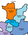
Variant 2: Formation of a "Wiehengebirgskreis"

Variant 3: Merging of the districts of Minden and Lübbecke without most of the areas south of the Wiehengebirge (to the district of Herford)

Variant 4: Union of the districts of Minden and Lübbecke (realized)

Variant 5: Greater Minden-Ravensberg district


Redesign of the communities


The proposals of the Lübbecke district for municipal and district reform provided counter-proposals for territorial continuity of the official boundaries. The reorganization of the municipalities into large municipalities should take place in two steps. In addition, only a moderate expansion of the cities of Espelkamp and Lübbecke was planned. A special case was planned for Levern-Alswede and Dielingen-Wehdem, as the respective main towns were located on the periphery, should the administration be divided or two sub-municipalities should be created, a path that was later followed in the municipality of Stemwede, which is today consists of three parishes.
In detail, the proposed levels looked as follows:
In the first stage, the aim was to hold onto a larger number of municipalities, which were to be grouped together by offices mainly in accordance with the previous regulations: The following administrative units were planned:
- Cities Espelkamp and Lübbecke
- Amt Hüllhorst (with the communities of Hüllhorst, Oberbauerschaft, Schnathorst)
- Amt Preußisch Oldendorf (with the communities Preußisch Oldendorf, Holzhausen, Börninghausen)
- Amt Rahden (with the communities Rahden, Varl, Wehe, Ton Heide, Prussisch Ströhen)
- Amt Dielingen-Wehdem (with the communities Dielingen, Haldem, Wehdem, Oppenwehe)
- Office Gehlenbeck (with the communities Gehlenbeck, Nettelstedt, Isenstedt, Frotheim)
- Amt Levern-Alswede (with the municipalities of Levern, Alswede)
For the second stage of the communal reorganization, the conversion of most of the offices into unified congregations was planned. As a result, the number of congregations should be reduced from 50 to 23 in the first stage and then further to 10 in the second stage. Only for the area of Dielingen-Wehdem and Levern-Alswede was the formation of two communities each under the bracket of the office meaningful in the long term, since the offices of Alswede-Levern and Dielingen-Wehdem lacked an undisputed central location.

After the major municipal reform on January 1, 1973: former municipalities now only in the old district of Lübbecke

Comparison of the old official boundaries (yellow) to the new municipality and district boundaries (white)


Population development
The following overview shows the population of the Rahden / Lübbecke district according to the respective territorial status. A change in the territorial status resulted from the incorporation of some communities into the dissolved district of Bünde on January 1, 1832. The numbers are census results or their extrapolation. From 1871 and 1946, the figures relate to the local population and from 1925 to the resident population . Before 1871, the population figures were determined using inconsistent survey methods. In the second half of the 19th century and after World War I , around 10,000 residents of the district emigrated to the United States.
|
|
|
|


In 1960 there were 15,700 displaced people in the district due to the Second World War .
The old district of Lübbecke


The area of the former Lübbecke district corresponds to the western part of the Minden-Lübbecke district . The term Altkreis Lübbecke is used unofficially, for example on the Altkreis-Lübbecke page: "The Altkreis-Lübbecke is a historically grown communication area in the Minden-Lübbecke district with the municipalities: Espelkamp, Hüllhorst, Lübbecke, Preußisch Oldendorf, Rahden, Stemwede."
With the merger in 1973, the district boundaries remained in a certain way untouched. The former border between the districts of Minden and Lübbecke is described by the eastern border of Espelkamp, Lübbecke and Hüllhorst, or the western border of Hille and Bad Oeynhausen, on the former border between the old districts of Minden and Lübbecke no municipal boundaries were changed.
With the unification of the districts, regional authorities were merged that on the one hand have many similarities, but on the other hand also show significant differences. Common to the districts is in principle the natural and cultural spatial structure with a portion of the Ravensberger Mulde in the south and the dominant North German Plain in the north, separated by the Wiehen / Weser Mountains, which cross from east to west. Both old districts also have a low proportion of forest areas in a state and national comparison and a correspondingly high proportion of agricultural areas. There is an obvious difference in the degree of urbanization: The old district of Minden shows signs of a conurbation in large areas, while the old district of Lübbecke is more rural and sparsely populated.
| Selected structural data in comparison |
Inhabitants / km² | Number of parishes |
average Liche area per municipality |
average Liche inhabitants per municipality |
Area share of the Ravensberg hill country |
Proportion of forest area in the respective area |
Share of agricultural Areas in the respective area |
Unemployment rate as of March 2015 |
|---|---|---|---|---|---|---|---|---|
| Minden-Lübbecke district | 274 | 11 | 104.7 km² | 28,708 | 14.0% | 11.2% | 65.7% | 5.9% |
| Altkreis Lübbecke | 190 | 6th | 94.1 km² | 17,877 | 6.3% | 12.4% | 69.6% | 4.6% |
| Altkreis Minden | 355 | 5 | 117.5 km² | 41,704 | 21.5% | 10.0% | 62.2% | 6.6% |
| OWL | 314 | 70 | 93.1 km² | 29,294 | - | 21.0% | 67.0% | 6.8% |
| NRW | 524 | 394 | 86.5 km² | 45,362 | - | 26.7% | 49.2% | 8.2% |
| Germany | 227 | 11.091 | 32.2 km² | 7,321 | 0.29% | 32% | approx. 50 % | 6.8% |
The former district area is divided into the cities of Lübbecke, Espelkamp, Preußisch Oldendorf and Rahden and the communities of Hüllhorst and Stemwede. The old district of Lübbecke has around 107,300 inhabitants (as of 2009) on an area of around 565 km², which corresponds to an average population density of 190 inhabitants per km². Its area covers almost 49% of the area and houses about 34% of the residents of the Minden-Lübbecke district.

The borders of the old Lübbecke district still exist
- the Evangelical Church District Lübbecke (spatially identical to the old district, apart from small differences),
- the football district league,
- the DRK district association Altkreis Lübbecke,
- the Lübbecke shooting club,
- the Volkshochschule Altkreis Lübbecke,
- the name Volksbank Lübbecker Land
- as well as the local editions of the Westfalen-Blatt ("Lübbecker Kreiszeitung") and the Neue Westfälische .
- the area of responsibility of the Lübbecke office of the Herford Employment Agency.
In Lübbecke, the Kreishausstraße is reminiscent of the former seat of the district administration. In addition, there are still institutions of a district town in Lübbecke with a tax office and an approval office for the road traffic office.
Economy and Infrastructure
traffic
The district was not touched by any motorway , the closest were the A 1 with a distance of about 30 km, the A 2 with a distance of about 15 km and the A 30 with a distance of about 5 km.
The district was opened up by the federal highways 51 , 65 and 239 as well as several district roads.
politics
Results of the district elections from 1946
The list only shows parties and constituencies that received at least two percent of the votes in the respective election.
Share of votes of the parties in percent
| year | SPD | CDU | FDP | BHE |
|---|---|---|---|---|
| 1946 | 36.7 | 61.5 | ||
| 1948 1 | 42.1 | 50.3 | 3.8 | |
| 1952 | 40.0 | 31.8 | 22.8 | 3.2 |
| 1956 | 42.1 | 35.0 | 18.3 | 4.1 |
| 1961 | 41.8 | 36.1 | 18.3 | 3.3 |
| 1964 | 46.7 | 36.3 | 17.0 | |
| 1969 2 | 44.7 | 40.7 | 9.6 |
Footnotes
1 1948: additional: KPD: 2.6%
2 1969: additional: NPD: 4.98%
District administrators
The district administrators of the Rahden and Lübbecke district were:
- 1817–1838 Georg von dem Bussche called von Münch
- 1838–1870 Adolf von der Horst
- 1871–1894 Ferdinand von Oheimb (brother of Alexander von Oheimb ) (1857, 1869–1871 already provisional)
- 1895–1917 Wilhelm von Ledebur
- 1918–1945 Kurt von Borries (1938–1939 deputy: Friedrich Hueter )
- 1945–1946 Otto Watermann
- 1946–1954 Heinrich Berg (CDU)
- 1954–1958 Gustav Niermann (CDU)
- 1958–1961 Heinrich Kosynowski (FDP)
- 1961–1969 Heinrich Schumacher (CDU)
- 1969–1972 Hermann Struckmeier (CDU)
Upper District Directors
The upper district directors of the Lübbecke district were:
- 1946–1952 Gustav Galle
- 1952–1967 Ernst Huchzermeyer
- 1967–1972 Rolf Momburg
coat of arms
Old coat of arms of the Lübbecke district from 1935 to 1968:
 |
Blazon : "In silver shields a red three-mountain, raised to the head of the shield, covered with a silver wave bar." |
| Justification of the coat of arms: The wavy bar indicates the etymological meaning of Lübbecke , which is derived from Hlid beki (Beki means Bach). The coat of arms colors are the colors of both the Principality of Minden and the County of Ravensberg. This coat of arms was approved by the Prussian State Ministry in 1935. |
New coat of arms of the Lübbecke district from 1968 to 1972:
|
|
Blazon : "In a silver shield a crenellated tower made of blue masonry on a red three-mountain, which is covered with two silver, crossed keys with turned away beards." |
| Foundation of the coat of arms: Tower and Dreiberg symbolize Limberg and the castle on Limberg. These symbols stand for the areas of the former Grafschaft Ravensberg , which were combined in the Limberg office and later made up the south-western part of the Lübbecke district. The key and the red field stand for the remaining parts of the circle that were formerly part of the Principality of Minden . The keys on a red ( Mindische ) ground can also be found in the coat of arms of the bishops of Minden , the city of Minden and in the coat of arms of the Minden-Lübbecke district . The latter also combines symbols of the County of Ravensberg and the Principality of Mindens. The keys symbolize the keys of Saint Peter . |
License Plate

On July 1, 1956, when the license plate was introduced, the district was assigned the distinctive sign LK . It was issued until December 31, 1972.
Occasionally vehicles still have this license plate, mainly vehicles and trailers used in agriculture and forestry. In 2011 there were still 1074 valid license plates with the code LK in the old district.
In the discussion about the license plate liberalization introduced on November 1, 2012 , local politicians in the Lübbecker Land spoke to one another. B. the mayor of the city of Lübbecke, to reintroduce its license plate for the old district of Lübbecke. However, the district committee of the Minden-Lübbecke district rejected a corresponding application in February 2012. The citizens' initiative Pro LK-Kennzeichen continues to campaign for the reintroduction. A corresponding signature campaign was announced for the beginning of 2013.
unemployment
The old district of Lübbecke, congruent with the area of responsibility of the Lübbecke branch of the Herford employment office district, traditionally has the lowest unemployment rate in OWLs. B. 2013 and 2014 moved between 4.3 and a maximum of 4.7 percent.
literature
- State Statistical Office of North Rhine-Westphalia: Statistical review for the Lübbecke district . Düsseldorf 1968.
- Gerhard Stalling AG (ed.): The district of Lübbecke. Publishing group municipal politics + economy, Oldenburg 1972.
- Adolf von der Horst: Statistical news about the Lübbecke district. Minden [1860] ( ULB Münster ).
Web links
- The architectural and art monuments of the Lübbecke district (1907)
- Administrative history of the Rahden / Lübbecke district on territorial.de
- Michael Rademacher: German administrative history from the unification of the empire in 1871 to the reunification in 1990. Lübbecke district. (Online material for the dissertation, Osnabrück 2006).
References and comments
- ^ Social gathering of the North District CDU . In: Neue Westfälische February 8, 2013.
- ↑ Statistical-topographical overview of the government district of Minden 1821. In: Digital Collections ULB Münster. P. 34 ff. , Accessed on March 3, 2014 .
- ↑ Westfalenlexikon 1832-1835 . In: Landschaftsverband Westfalen-Lippe (Ed.): Reprints for the Westphalian archive maintenance . tape 3 . Münster 1978, p. 166 (reprint of the original from 1834).
- ^ Official Journal of the Minden Government 1843: Formation of the offices in the Lübbecke district
- ↑ Landgemeinde -ordnung for the Province of Westphalia from October 31, 1841 (PDF; 1.6 MB)
- ^ Stadtinfo Rahden: History of Sielhorst
- ^ A b c Wolfgang Leesch: Administration in Westphalia 1815–1945 . In: Publications of the Historical Commission for Westphalia . tape 38 . Aschendorff, Münster 1992, ISBN 3-402-06845-1 , p. 380 .
- ^ Wolfgang Leesch: Administration in Westphalia 1815-1945 . In: Publications of the Historical Commission for Westphalia . tape 38 . Aschendorff, Münster 1992, ISBN 3-402-06845-1 , p. 387 .
- ^ Wolfgang Leesch: Administration in Westphalia 1815-1945 . In: Publications of the Historical Commission for Westphalia . tape 38 . Aschendorff, Münster 1992, ISBN 3-402-06845-1 , p. 396 .
- ↑ Announcement of the new version of the district regulations for the state of North Rhine-Westphalia from August 11, 1969 in the Law and Ordinance Gazette for the state of North Rhine-Westphalia, year 1969, No. 2021, p. 670 ff.
- ^ Federal Statistical Office (ed.): Historical municipality directory for the Federal Republic of Germany. Name, border and key number changes in municipalities, counties and administrative districts from May 27, 1970 to December 31, 1982 . W. Kohlhammer, Stuttgart / Mainz 1983, ISBN 3-17-003263-1 , p. 324 f .
- ↑ Page of the Mühlenkkreis Minden-Lübbecke article series 40 years of the Minden-Lübbecke district
- ↑ a b Dirk Möllering (Ed.): Structure and structural change in the old district of Lübbecke . Lübbecke 2001, p. 427 ff.
- ↑ State Statistical Office of North Rhine-Westphalia: Municipal statistics of the State of North Rhine-Westphalia: population development 1816–1871 . Düsseldorf 1966, pp. 60-63.
- ↑ State Statistical Office of North Rhine-Westphalia: Municipal statistics of the State of North Rhine-Westphalia: Population development 1871–1961 . Düsseldorf 1964, pp. 66-67.
- ↑ State Statistical Office of North Rhine-Westphalia: The resident population in the municipalities of North Rhine-Westphalia 1970: Results of the census on May 27, 1970 . Düsseldorf 1972, p. 41.
- ↑ Statistical Yearbook for the Federal Republic of Germany 1973
- ↑ Heinz-Ulrich Kammeier: The United States in 1869, 1877, 1927 and 1928 in letters from emigrants from the Lübbecke district. Messages of the Mindener Geschichtsverein, year 56 (1984), pp. 101–111.
- ^ Heinz-Ulrich Kammeier: Aspects of the emigration to America from the former offices of Levern and Gehlenbeck between 1850 and 1860. Communications from the Mindener Geschichtsverein, volume 59 (1987), pp. 91-102.
- ^ Michael Rademacher: German administrative history from the unification of the empire in 1871 to the reunification in 1990. Lübbecke district. (Online material for the dissertation, Osnabrück 2006).
- ↑ Internet presence of the old district Lübbecke
- ↑ The Lower Saxon towns of Büscherheide and Stemshorn also belong to the Lübbecke church district
- ↑ Source: respective issue of the State Statistical Office (LDS NRW), Mauerstr. 51, Düsseldorf, with the election results at the district level.
- ↑ Article on the reintroduction of the old license plates
- ↑ Article in the Mindener Tageblatt ( Memento of the original from November 3, 2013 in the Internet Archive ) Info: The archive link was inserted automatically and has not yet been checked. Please check the original and archive link according to the instructions and then remove this notice.
- ^ Article in the NW
- ^ Article in the NW
- ↑ Monthly report of the Detmold district government ( Memento of the original from June 23, 2015 in the Internet Archive ) Info: The archive link was inserted automatically and has not yet been checked. Please check the original and archive link according to the instructions and then remove this notice.

Before the founding of North Rhine-Westphalia in what is now North Rhine-Westphalia, the (rural) districts: Bilstein | Blankenheim | Bochum | Brakel | Frets | Dortmund | Duisburg | Düsseldorf | Elberfeld | Eslohe | Food | Geilenkirchen | Gelsenkirchen | Gemünd | Gimborn | Gladbach | Grevenbroich-Neuss | Gummersbach | Hagen | Hamm | Hattingen | Heinsberg (1816-1932) | Homburg | Hörde | Kempen | Krefeld | Lechenich | Lennep | Medebach | Mettmann | Mülheim am Rhein | Mülheim an der Ruhr | Neuss | Opladen | Rahden | Rheinbach | Rheinberg | Ruhrort | Schwelm | Solingen | Solingen-Lennep | Uckerath | Waldbröl | Wipperfürth
Former North Rhine-Westphalian (rural) districts: Aachen (1816–1971) | Aachen (1972–2009) | Ahaus | Altena | Arnsberg | Beckum | Bergheim (Erft) | Bielefeld | Bonn | Borken (1816–1974) | Brilon | Büren | Coesfeld (1816–1974) | Detmold | Dinslaken | Düren (1816–1971) | Düsseldorf-Mettmann | Erkelenz | Geilenkirchen-Heinsberg | Geldern | Grevenbroich | Halle (Westphalia) | Höxter (1816–1974) | Iserlohn | Jülich | Kempen-Krefeld | Cologne | Lemgo | Lippstadt | Lübbecke | Lüdenscheid | Lüdinghausen | Meschede | Minden | Moers | Monschau | Munster | Paderborn (1816–1974) | Rees | Rhein-Wupper-Kreis | Schleiden | Selfkantkreis Geilenkirchen-Heinsberg | Victories | Siegkreis | Soest (1817–1974) | Steinfurt (1816–1974) | Tecklenburg | Unna (1930–1974) | Warburg | Warendorf (1816–1974) | Wiedenbrück | Wittgenstein

Districts: Ahaus | Altena | Arnsberg | Beckum | Bielefeld | Bilstein | Bochum | Bark | Brakel | Brilon | Frets | Büren | Coesfeld | Dortmund | Ennepe-Ruhr district | Eslohe | Gelsenkirchen | Hagen | Halle (Westphalia) | Hamm | Hattingen | Herford | Hörde | Höxter | Iserlohn | Lippstadt | Lübbecke | Lüdinghausen | Medebach | Meschede | Minden | Munster | Olpe | Paderborn | Rahden | Recklinghausen | Schwelm | Victories | Soest | Steinfurt | Tecklenburg | Unna | Warburg | Warendorf | Wiedenbrück | Wittgenstein
City districts: Bielefeld | Bocholt | Bochum | Bottrop | Buer | Castrop-Rauxel | Dortmund | Gelsenkirchen | Gelsenkirchen-Buer | Gladbeck | Hagen | Hamm | Herford | Herne | Hörde | Iserlohn | Lüdenscheid | Lünen | Minden | Munster | Osterfeld | Recklinghausen | Victories | Wanne-Eickel | Wattenscheid | Witten