
Castrop-Rauxel
| coat of arms | Germany map | |
|---|---|---|

|
Coordinates: 51 ° 33 ' N , 7 ° 19' E |
|
| Basic data | ||
| State : | North Rhine-Westphalia | |
| Administrative region : | Muenster | |
| Circle : | Recklinghausen | |
| Height : | 98 m above sea level NHN | |
| Area : | 51.68 km 2 | |
| Residents: | 73,343 (Dec. 31, 2019) | |
| Population density : | 1419 inhabitants per km 2 | |
| Postcodes : | 44575, 44577, 44579, 44581 | |
| Primaries : | 02305, 02367 | |
| License plate : | RE, CAS, GLA | |
| Community key : | 05 5 62 004 | |
| LOCODE : | DE CRL | |
| City structure: | 15 districts | |
City administration address : |
Europaplatz 1 44575 Castrop-Rauxel |
|
| Website : | ||
| Mayor : | Rajko Kravanja ( SPD ) | |
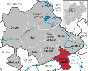
| Location of the town of Castrop-Rauxel in the Recklinghausen district | ||
  |
||

Castrop-Rauxel [ kas · tʀɔp ʀaʊ̯k · SL ] is a large district town in the district of Recklinghausen in the administrative district of Münster in North Rhine-Westphalia . The Ruhr area city is represented in the Ruhr Regional Association (RVR) by the Recklinghausen district and is part of the Rhine-Ruhr metropolitan region . In the state planning of North Rhine-Westphalia, Castrop-Rauxel is classified as a medium-sized center .
Castrop-Rauxel's townscape was heavily influenced by mining in the 19th and 20th centuries . In the course of industrialization, the Erin , Graf Schwerin , Ickern and Victor mines were built . The closure of the Erin colliery in 1983 meant the end of mining in Castrop-Rauxel. Industrial monuments such as the headframe of the Erin colliery and its hammer head tower remind of this tradition; the earlier motto industrial city in the green was changed accordingly to European city in the green .
geography
Spatial location
Castrop-Rauxel is located in the Emscherland , the northern part of the Ruhr area, and as a town in the Recklinghausen district, it belongs to the Rhine-Ruhr metropolitan region . The Rhine-Herne Canal and Emscher run through the northern districts of Pöppinghausen, Habinghorst, Henrichenburg and Ickern, with the traditionally vest-like Henrichenburg being separated from the Habinghorst, which runs south of the canal here, from the Habinghorst that adjoins it to the south.
Urban area


The urban area of Castrop-Rauxel has a total area of 51.66 km². The extension in the north-south direction is 11.8 km and the west-east extension 9.3 km. The highest point in the city is marked by the Schwerin dump at 147 m above sea level, the lowest on Pöppinghauser Strasse next to house no. 264 at 50.2 m above sea level. The mean altitude is 98.6 m above sea level.
The city is divided into 15 districts, from north to south and within a line from west (southwest) to east (northeast) these are:
- Henrichenburg (with Becklem in the far north)
- Poeppinghausen , Habinghorst , Ickern
- Bladenhorst , Rauxel , Deininghausen
- Behringhausen , Castrop , things
- Obercastrop , Schwerin
- Bövinghausen , Merklinde , Frohlinde
Apart from the younger district Schwerin, which occupies the southern districts and Castrops Rauxel, today districts correspond exactly to since 1975 unchanged districts .
Land use
The total area of the urban area is divided into different types of use (as of December 31, 2010):
| Surfaces | in m² | in % |
|---|---|---|
| Building and open space | 16,384,832 | 31.7% |
| Operating area | 1,497,843 | 2.9% |
| Recreation area | 2,835,924 | 5.5% |
| traffic area | 6,191,789 | 12.0% |
| Agricultural area | 14,116,843 | 27.3% |
| Forest areas | 7,938,248 | 15.4% |
| Water surface | 1,941,522 | 3.8% |
| Areas of other use | 758.372 | 1.5% |
| total area | 51,665,373 | 100 % |
Population numbers
The districts usually form a statistical district at the same time; at Henrichenburg (dividing line is the B 235 ), Ickern ( A 2 , further southeast the Emscher ) and Rauxel ( A 42 ) there are two each. The following population figures are allotted to the statistical districts (as of 2012):
| Statistical district | Check- residents |
Area / km² |
EW / km² |
|---|---|---|---|
| Behringhausen | 1,810 | 1.6 | 1130 |
| Bladenhorst | 1,172 | 4.5 | 260 |
| Bövinghausen | 2,274 | 1.0 | 2270 |
| Castrop | 8,416 | 2.8 | 3010 |
| Deininghausen | 1,897 | 3.0 | 630 |
| things; matters | 921 | 1.9 | 480 |
| Frohlinde | 3,426 | 2.6 | 1320 |
| Habinghorst | 8,934 | 4.3 | 2080 |
| Henrichenburg East | 3,902 | 2.4 | 1630 |
| Henrichenburg West | 1,561 | 5.2 | 300 |
| Ickern North | 3,798 | 2.1 | 1810 |
| Ickern south | 11,863 | 5.1 | 2330 |
| Merklinde | 1,063 | 1.7 | 630 |
| Obercastrop | 6.212 | 2.6 | 2390 |
| Poeppinghausen | 793 | 3.6 | 220 |
| Rauxel North | 4,504 | 2.7 | 1670 |
| Rauxel South | 6,304 | 2.4 | 2630 |
| Schwerin | 6,471 | 2.6 | 2490 |
The population densities are numbers over entire statistical districts; z. B. Henrichenburg Ost to the north only up to the A2, i.e. without the almost uninhabited Borghagen, the population density would be 6,000 inhabitants per square kilometer.
Neighboring municipalities and neighboring cities
The following cities border the city of Castrop-Rauxel - clockwise, starting in the north:
Recklinghausen , Datteln , Waltrop (all Recklinghausen district ), Dortmund , Bochum and Herne .
Nature reserves
- Berry break
- Habinghorst
- Langeloh
- Pöppinghauser Forest
- Smart
- Lessmöllmann clay pit
- Broken wagon sources
history


On the site of the later Erin colliery in Castrop, there was a Germanic settlement that had close economic ties with the Roman Empire from the end of the 1st to the 5th century AD.
During the Saxon War, Charlemagne set up food depots and imperial courts along the streets and used the Roman road on his march north. The Imperial Courts developed into localities, in this case Castorp (Dorf am Speicher) became Castrop.
Villa Castrop was first mentioned in a document in 834 . In 1484, John II of Cleve issued the citizens a letter of freedom. In 1902 the city of Castrop was created from the titular town of Castrop and two other communities. On April 1, 1926, the town of Castrop-Rauxel was formed from parts of the town of Castrop and the Rauxel office . Initially it belonged to the district Dortmund before the 1 April 1928 acyclic was.
During the air war, Castrop-Rauxel was the target of Allied air strikes on the Ruhr area five times , in which a total of 398 people were killed. Mainly the large industrial areas such as the mines and chemical plants were badly hit, but were mostly able to resume operations after a short time. However, numerous bombs also fell on residential areas. In total, Castrop-Rauxel was destroyed to 24%, which was a relatively low degree of destruction compared to other cities in the Ruhr area.
On March 7, 1945, Castrop-Rauxel was again the target of heavy American air raids. The Rütgerswerke and tar recycling were hit hard. On March 13, another serious attack took place on the Erin colliery, which had to stop production for a few days after the attack. On March 15, the Rütgerswerke were again the target of American air strikes.
On April 1, 1945, Castrop's Lord Mayor Anton and the highest officials and employees met and discussed the Fuehrer's order to destroy all bridges, supply lines and production facilities when the enemy approached. It was unanimously decided to ignore this order. The local commander of the German armed forces announced to the mayor at 5 pm: “Castrop is now a battle zone!” On April 2, the Americans reached Castrop-Rauxel in the north, with Pöppinghausen as the first district to fall into American hands. The Germans had already withdrawn behind the canal and blown up the Bladenhorst canal bridge, the Schemhof bridge on Wartburgstrasse, the bridge on Hebewerkstrasse and all the Emscher bridges. After the district leader Nieper resigned , the Volkssturm was also disarmed and disbanded on April 4th.
For the first time the Americans encountered heavy resistance again, because Castrop was well manned for the relatively small section of the front and was heavily defended. At the end of 1944 Castrop began to attach anti-tank barriers, one-man foxholes and 8.8 cm and 2 cm flak installed on concrete bases. On the German side, the 2nd and 23rd regiments of the 2nd Paratrooper Division and a battalion of the Army Police with assault guns faced the well-equipped American troops of the 289th Regiment of the 26th US Infantry Division. According to combat reports from the 26th US Infantry Division, the resistance in Castrop-Rauxel was tougher than in the Arch of the Ardennes and in the Colmar pocket. On April 8, American troops finally took the old town and Beringhausen. The last bitter resistance took place on April 9th in the Merklinde area. However, these defenders withdrew in the direction of Merklinde.
Incorporations
On April 1, 1902 arose from the titular town Castrop and communities Behringhausen and Obercastrop the city Castrop . On April 1, 1926, the town of Castrop with the communities of Rauxel, Bövinghausen bei Castrop , Frohlinde , Merklinde , Habinghorst (until then Amt Rauxel ), Bladenhorst, Pöppinghausen (until then Amt Bladenhorst ), parts of Deininghausen, Dingen and Ickern (until then Amt Mengede ) to the new city Castrop-Rauxel merged . On April 1, 1928, the rest of Deininghausen was incorporated into the new town.
On January 1, 1975, in the course of local reorganization, the municipality of Henrichenburg was incorporated into the city of Castrop-Rauxel. At the same time this was a district town in the district of Recklinghausen and changed at the same time from Arnsberg to Münster Region .
Population development


Until the beginning of the 19th century, Castrop had only a few hundred inhabitants. The population grew only slowly and fell again and again due to the numerous wars, epidemics and famine. The Thirty Years War (1618–1648) and a plague epidemic in 1636 claimed numerous lives. Only with the beginning of industrialization did the population grow very quickly. In 1818 only 646 people lived in the place, in 1900 there were already 9,400. The incorporation of Behringhausen and Obercastrop in 1902 brought an increase of 5,000 people. On April 1, 1926, the merger of the town of Castrop with ten rural communities resulted in the new town of Castrop-Rauxel with 53,399 inhabitants.
After the end of the Second World War , the influx of refugees and displaced persons from the German eastern areas led to a strong increase in the number of inhabitants. Their share of the total population of the city was around a quarter in 1962 with around 22,000 people. In the same year the population reached its historic high of 88,923. On June 30, 2005, the official population for Castrop-Rauxel was 77,780 according to updates by the State Office for Data Processing and Statistics North Rhine-Westphalia (only main residences and after comparison with the other state offices). That was around 13 percent (11,143 people) fewer than in 1962.
The following overview shows the population of Castrop (until 1925) and Castrop-Rauxel (from 1926) according to the respective territorial status. These are census results (¹) or official updates from the State Statistical Office. From 1871, the information relates to the “local population”, from 1925 to the resident population and since 1987 to the “population at the location of the main residence”. Before 1871, the number of inhabitants was determined according to inconsistent survey procedures.
| year | Residents |
|---|---|
| 1699 | 320 |
| 1798 | 546 |
| 1818 | 646 |
| December 3, 1849 ¹ | 1,190 |
| December 1, 1871 ¹ | 2,105 |
| December 1, 1885 ¹ | 3,724 |
| December 1, 1890¹ | 4,988 |
| December 1, 1900 ¹ | 9,400 |
| December 1, 1905 ¹ | 16,422 |
| December 1, 1910¹ | 18,516 |
| December 1, 1916 ¹ | 17,358 |
| December 5, 1917 ¹ | 18,485 |
| October 8, 1919 ¹ | 18,961 |
| June 16, 1925 ¹ | 18,480 |
| June 16, 1933 ¹ | 58,372 |
| May 17, 1939 ¹ | 56,610 |
| December 31, 1945 | 54,653 |
| October 29, 1946 ¹ | 58,292 |
| September 13, 1950 ¹ | 69,960 |
| September 25, 1956 ¹ | 83,376 |
| year | Residents |
|---|---|
| June 6, 1961 ¹ | 87,910 |
| December 31, 1965 | 87.909 |
| May 27, 1970 ¹ | 84,146 |
| June 30, 1974 | 79,346 |
| December 31, 1975 | 82,373 |
| December 31, 1980 | 78,877 |
| December 31, 1985 | 76,430 |
| May 25, 1987 ¹ | 77,081 |
| December 31, 1990 | 79,037 |
| December 31, 1995 | 79.160 |
| December 31, 2000 | 78,608 |
| December 31, 2005 | 77,619 |
| December 31, 2010 | 75,408 |
| May 9, 2011 ¹ | 74,628 |
| December 31, 2015 | 74,220 |
| December 31, 2016 | 74.004 |
| December 31, 2017 | 73,989 |
¹ census result
Denomination statistics
As of December 31, 2019, 28% of the population had the Protestant denomination, 33% the Roman Catholic and 39% belonged to other denominations or religious communities or are non-denominational . A year earlier, 29% of the population had the Protestant denomination, 34% the Roman Catholic and 37% belonged to other denominations or religious communities or were non-denominational . As of December 31, 2000, 35% of the population had the Protestant denomination and 41% the Roman Catholic .
Street names
Over the years streets and squares have been renamed. In Castrop-Rauxel names reminiscent of the empire were removed during the Weimar period. After the war, the city decided to ban all national socialist and soldiery terms.
- Berlin Square
- Bahnhofstrasse (section), Berliner Platz (1987)
- Kirchstrasse
- Königstrasse, Kirchstrasse (1926?)
- Long street
- Kronprinzenstrasse, Castroper Strasse (1923), Adolf-Hitler-Strasse (1933), Lange Strasse (1945)
- Ruprecht Street
- Ottostraße, Ruprecht-Straße (1926)
- Vinckeplatz
- Kaiserplatz, Vinckeplatz (1926?)
- Wartburgstrasse
- Kaiserstrasse, Wartburgstrasse (?)
politics
City council
After the local elections on May 25, 2014, the 50 seats in the city council are distributed as follows:
| list | SPD | CDU | FDP | Green | FWI | left | UBP | total |
|---|---|---|---|---|---|---|---|---|
| Seats | 20th | 15th | 2 | 4th | 4th | 3 | 2 | 50 |
Results of the local elections from 1975
Only parties and voter communities that received at least 1.95 percent of the votes in the respective election are shown in the list.
| year | SPD | CDU | Green 1 | FWI | Left 2 | FDP | UBP 3 |
|---|---|---|---|---|---|---|---|
| 1975 | 56.2 | 36.9 | 5.5 | ||||
| 1979 | 56.0 | 37.1 | 5.4 | ||||
| 1984 | 54.3 | 32.2 | 10.1 | 2.8 | |||
| 1989 | 46.9 | 27.6 | 11.2 | 10.6 | 3.7 | ||
| 1994 | 51.4 | 30.6 | 6.9 | 9.5 | 1.6 | ||
| 1999 | 40.7 | 42.0 | 4.1 | 11.3 | 1.9 | ||
| 2004 | 43.1 | 35.6 | 6.7 | 6.5 | 3.3 | 3.4 | |
| 2009 | 43.0 | 27.0 | 6.8 | 5.1 | 5.4 | 8.9 | 2.3 |
| 2014 | 40.1 | 30.6 | 8.0 | 7.5 | 5.3 | 4.4 | 4.1 |
Footnotes
- 1 Greens: 1984 to 1994: GAL, from 1999: B'90 / The Greens
- 2 Left: 2004: PDS, 2009: The Left
- 3 UBP: Independent Citizens' Party
City leaders
- Lord Mayor
- 1926–1933: Georg Mende , center (mayor, from 1928 mayor)
- 1933–1945: Richard Anton, NSDAP
- 1945–1946: Arnold Boerboom
- 1946–1948: Hubert Krehe, CDU
- 1948–1971: Wilhelm Kauermann, SPD
- 1971–1975: Hugo Paulikat , SPD
- mayor
- 1975–1989: Hugo Paulikat, SPD
- 1989–1999: Hans Ettrich, SPD
- 1999-2004: Nils Kruse, CDU
- 2004–2015: Johannes Beisenherz , SPD
- since 2015: Rajko Kravanja, SPD
coat of arms

The city's coat of arms shows a gold St. Andrew's cross in a blue field, with the bar above the other from top left to bottom right. The oldest surviving document showing the St. Andrew's cross dates from 1512.
The town of Castrop , formed in 1902 from the municipalities of Castrop , Obercastrop and Behringhausen, adopted the old emblem, the St. Andrew's Cross, with the colors blue and gold, which have been handed down since the 17th century, as the town's coat of arms. The then district president of Arnsberg approved the use of the city coat of arms on January 28, 1911. Due to an official Prussian regulation, however, a three-tower wall crown had to be placed on the coat of arms.
On August 30, 1926, this coat of arms was adopted for the new town of Castrop-Rauxel, which the Prussian State Ministry approved on November 24, 1926. On July 15, 1965, the crown of the wall was removed from the coat of arms because it was historically unfounded. Accordingly, the city coat of arms has been used in its historically traditional form since August 1, 1965.
Town twinning
There are city partnerships with the following cities:
-
 Wakefield , United Kingdom , since 1949
 -
 Vincennes , France , since 1961
 -
 Kuopio , Finland , since 1965
 -
 Zehdenick , Brandenburg , since 1990
 -
 Nowa Ruda , Poland , since 1991
 -
 Trikala , Greece , since 2013
 -
 Zonguldak , Turkey , since 2013
From 1950 to 2000 the Dutch city of Delft was twin town of Castrop-Rauxel. The city of Castrop-Rauxel was awarded the Theodor-Heuss-Preis in 1979 for its city partnership commitment .
Culture and sights


Art in public space
See: List of works of art in public space in Castrop-Rauxel
Theater and cinema
The Westphalian State Theater (WLT) and the Callo Theater project come from Castrop-Rauxel. In the 1950s, the city still had numerous cinemas, and Lange Strasse in Habinghorst was particularly popular as an entertainment mile. The last motion picture theater to close in 2014 was the crank on Obere Münsterstrasse.
Buildings
See also: List of architectural monuments in Castrop-Rauxel
Important structures in Castrop-Rauxel are the hammer head tower and the full-walled strut frame of the former Erin colliery . As industrial monuments, they bear witness to the town's mining past. This also includes the Schwerin dump with a walk-in sundial on the site of the former Graf Schwerin colliery .
Also worth seeing are the Bladenhorst Castle , a moated castle in the Bladenhorst district, the St. Lambertus Church in the Henrichenburg district , the Luther Church from 1881 in the old town, the Taubenvatta monument , a bronze monument that has been on the Kuopio since 1986. Platz is and the Jewish cemetery from 1743. This is the oldest surviving cemetery. The Goldschmieding house , built at the end of the 16th century, now houses a castle restaurant and is located in a park not far from the former horse racing track , where the nationally known natural obstacle races took place from 1874 to 1970. Today there is a local recreation area there. The equestrian monument erected in 1912 on the old town market is a reminder of the horse racing tradition.
In the old town can also be found the the in Westfalen particularly revered Lambert of Liege , Bishop of Maastricht, consecrated Church , whose origins date back to the year 1250th In the oldest part still preserved there is a sacrament house made of Baumberger sandstone , which was created around 1512.
The St. Antonius Church in the Ickern district, named after Antonius of Padua , differs surprisingly from these partly medieval, partly historicist churches . The influx of many Catholics, especially from Poland, at the beginning of the 20th century required a new building. It was designed by Alfred Fischer from 1922 to 1925 . If the outside is reminiscent of Fischer's administrative and industrial buildings, the inside presents itself as something new. Formally it is a basilica with a central nave, two lower aisles, a tower porch and an apse. However, the whole space is divided by parabolas . Parabolic arches span the central nave, separate the central nave from the aisles and form the passages from the tower hall and the choir. A lot of light falls through the large, elliptical top window . Since the last restoration in 1989/90, the condition has come closer to the original. The building has been attributed to Expressionism .
The city garden is located on the edge of the old town . The Parkbad Süd , which opened in 1926 and closed in 1992, is also located there . After it was closed, it was placed under a preservation order and is now a cultural and leisure center with restoration. The bunker Münsterstraße , built in 1942, was blown up in 1975.
The Castrop-Rauxel power plant was located in Habinghorst and had what was once the tallest structure in the city (230 m high chimney). It was the most modern hard coal power plant at the time and has been in operation since 1956. It was last used as a reserve power station. Its operation was stopped in 2001 due to overcapacity, the chimney was blown on April 6, 2008.
The 27-hole golf course Frohlinde extends to the south of the city. In addition to the special sporting features of this 132 hectare facility in the middle of the Ruhr area, the golf course is characterized by a beautiful landscape setting and extensive implementation of the requirements of nature and landscape protection.
The Henrichenburg Landscape Archaeological Park in the north of the city brings the history of Henrichenburg Castle back to life at its historical location. The castle was first mentioned in a document in 1263 and demolished in 1787 due to dilapidation.
The Forum Europaplatz , located in the center of the city, is a culturally versatile event and congress center. The center of the forum consists of the town hall and the Europahalle, designed according to plans by the Danish architect Arne Jacobsen , who also designed the new town hall.
Sports
The Castrop-Rauxeler Korfball is leading in Germany. Domestic clubs make up the majority of German national players and have represented Germany in European Cups for years. Castrop-Rauxel has been Germany's beach tennis stronghold since 2003 and provides players from the tennis department of the Rauxel 1922 e. V. Masters at the German and European level. The rowing department of the rowing club Rauxel 1922 e. V. has produced many German champions and world champions since it was founded. In 1988 the club celebrated its greatest sporting success to date: the Rauxel rower Eckhardt Schultz became Olympic champion in Germany eighth . The rowers Magdalena Jakschick and Jannis Augustin also won silver and gold medals at the 2007 Junior World Championships in Beijing.
With ABC Merklinde , a Castrop billiards club is represented in the 1st Bundesliga all- around in the 2016/2017 season. Furthermore, in the 2016/2017 season, a Castrop-Rauxeler billiards club was represented in the 2nd Bundesliga three cushion for the first time, after the ABC made it up this year. The league team three cushion is the German team champion of the 2009/2010 season (small billiards). With this title Merklinde became the most successful tournament billiards club in the history of the Federal Republic of Germany. Ronny Lindemann and Markus Dömer managed to win an international title. In September 2008, starting for ABC Merklinde, you became European champion in team three-cushion (small billiards) at the European Championships in Brandenburg. Other traditional Castrop billiard clubs are Billardfreunde Castrop-Schwerin 1928 e. V. and the pool billiard club Castrop from Schwerin.
The top-class soccer clubs in the city are the regional league clubs FC Frohlinde and SV Wacker Obercastrop and the district league clubs SG Castrop and Spvg Schwerin . The first men's team of SV Castrop-Rauxel played from the 1993/94 season to the 2001/02 season in the Bundesliga .
Regular events

Regular events in Castrop-Rauxel include the spring and autumn fair with fireworks on the evening of the opening day. The culinary festival Castrop, which has been held since the early 1990s, starts every year in early summer at the Castrop old town market. The annual events in the old town of Castrop include Home & Garden in spring and the Viktualienmarkt in autumn. In late summer, the WLT open-air theater sets up its tents with theater performances on the Castrop market square. In addition, the SPD Castrop-Rauxel organizes the live event Rock under the winding tower once a year in Erinpark . At Christmas time there is a regular Christmas market in the old town, which is complemented by the culinary tent in Advent on the market square. In addition, the dance under the rainbow takes place annually for the benefit of AIDS patients and those infected with HIV.
The regular events include the Say-No-Party , as well as the two rock festivals Steel-meets-Steel Festival and Save The Planet Festival . There is also the so-called Casterix holiday program every year, which offers discounts for children at municipal facilities such as B. Includes swimming pools.
Prizes and awards
- 1952 The British Queen gives the city a pair of swans as thanks for the development of the German-British friendship
- 1962 Honorary title “Community of Europe” - awarded in 1962 by the Council of Europe .
- 1979 Theodor Heuss Prize
The Theodor-Heuss-Preis was awarded to the city of Castrop-Rauxel and citizens on March 11, 1979 by the Foundation Theodor-Heuss-Preis e. V. for her exemplary commitment to European understanding and her efforts to promote Europe during a grand ceremony in the Herkulessaal of the Munich Residence from the hands of chairwoman Hildegard Hamm-Brücher . Federal Foreign Minister Hans-Dietrich Genscher gave the keynote lecture on the subject of “Citizen Engagement for Europe” .
Others
- As part of RUHR.2010 - European Capital of Culture , in which the city of Castrop-Rauxel u. a. participated with a trailer for a new city film, the television film Zeche is nich - Seven Views of the Ruhr Area 2010 was made with the participation of the ZDF small television game . In the resulting episode Thomas, Thomas der Castrop-Rauxelerin director Corinna Liedtke , Wolfgang Weber, an archivist from Castrop-Rauxel, claims that Thomas Vallomtharayil, managing director of the Castrop-Rauxeler Medical Park Ruhr , is the reborn Irish entrepreneur William Thomas Mulvany .
- The bands Positive Strike and Eskimo Callboy also come from the city .
Economy and Infrastructure

The town of Castrop-Rauxel has one of the lower average primary incomes per inhabitant in the Recklinghausen district. In a national comparison, it was ranked 354 among the 396 municipalities in North Rhine-Westphalia in terms of average disposable income in 2016. Castrop-Rauxel is one of the lower-income municipalities in the state.
Established businesses
Today, the economic structure of Castrop-Rauxel is characterized by medium-sized and small companies. Of the numerous large industrial companies in Castrop, Rütgers Chemicals GmbH remains with around 720 employees. The company was sold by Evonik to the financial investor Triton in December 2007 , who sold Rütgers to the Indian Rain Commodities Limited in 2013.
traffic
Trunk roads

The federal highways 2 ( Oberhausen - Berlin ), 42 ( Kamp-Lintfort - Dortmund ) and 45 (Dortmund - Aschaffenburg ) run through the urban area . The A 42 crosses with the A 45 at the Castrop-Rauxel-Ost junction . The B 235 from Senden to Witten , with a connection to the A 40 / B 1 just south of the city limits in Dortmund, crosses the city from north to south.
Public transport


From Castrop-Rauxel main station , the Rhine-Ruhr S-Bahn runs with the line (S 2) ( Cologne-Mindener route ) to Dortmund and Duisburg / Essen / Recklinghausen . The Rhein-Emscher-Express (RE 3) from Hamm to Düsseldorf also stops . The Emschertal Railway (RB 43) runs from Dortmund to Dorsten from the Castrop-Rauxel Süd (old town) and Castrop-Rauxel-Merklinde stops .
In Castrop-Rauxel there are a total of 18 Bogestra bus routes (routes 353, 364, 378), DSW21 (480, 481, 482, NE 11), HCR (311, 321, 324, 341, 347, 351, 361) and of Vestische Straßenbahnen GmbH (233, 237, SB 22). The city express bus (SB 22) connects Castrop-Rauxel with Datteln . In addition, a night bus (NE 11) operates as a ring line between Ickern / Henrichenburg and Dortmund city center. From May 2011 the Vestische bicycle bus operated exclusively on Sundays and public holidays as line 200 from Castrop-Rauxel main station via Datteln to Haltern am See station . This offer was discontinued at the end of the 2013 season.
Most bus routes cross the city limits. The central bus stop is the bus station on Münsterplatz in downtown Castrop. The Castrop-Rauxel Süd stop is in the immediate vicinity , so that a direct change between the bus lines and the regional train line RB 43 is possible.
Furthermore, in the development plan, the expansion of the light rail line from Dortmund-Westerfilde via Castrop-Rauxel-Frohlinde, Merklinde and Münsterplatz (bus station) to the main station is planned.
The tariff of the Verkehrsverbund Rhein-Ruhr (VRR) applies to all local public transport . The NRW tariff applies across the tariff area .
Shipping

The Rhine-Herne Canal connects Castrop-Rauxel with the German waterway network . The Rhine-Herne Canal, which crosses the city in the north, is an important traffic route and on it there is a marina for leisure captains. In the Castrop-Rauxeler urban area there are a total of four canal ports along the canal: on the one hand, the port of Victor and the port of Rütgers , both of which are not far from Bladenhorst Castle , on the other hand, the canal port of Luck and the port of Marmorit , which is at the level of Wartburgstrasse . The latter is more likely to be described as a landing stage. In addition, the AMC marina with two docks is located in the Pöppinghausen district .
At the Emscher pass in Henrichenburg, the Emscher is passed under the Rhine-Herne Canal. At the same time, this is the eastern beginning of the " island " between the canal and the river, which extends to Oberhausen and which is to be further upgraded in terms of landscape in the course of the renaturation of the Emscher.
media
The Westdeutsche Allgemeine Zeitung , the Westfälische Rundschau and the Ruhr Nachrichten appear in Castrop-Rauxel , each with a local edition. All newspapers have a local editorial office in the old town of Castrop. The Ruhr Nachrichten also has an office in the city. In addition, the city gazette for Castrop-Rauxel is published free of charge on Wednesdays and Saturdays and a free city magazine is available to take away in the shops. In addition to the print editions, there is also the online magazine online-lokalteil.de , as well as the local compass operated by the city gazette .
The TV learning channel nrwision bundles TV and radio broadcasts about Castrop-Rauxel and from TV and radio producers from Castrop-Rauxel in its media library.
Healthcare
Hospitals
- Evangelical Hospital Castrop-Rauxel : The EvK belongs to the Ev. Hospital Community Herne | Castrop-Rauxel gGmbH , which alsooperatesthe EvK Herne . The Evangelical Hospital Castrop-Rauxel is, like the EvK Herne, an academic teaching hospital of the University of Duisburg-Essen. The hospital is not far from the city center.
- Catholic Hospital St. Rochus-Hospital : Since 2004 the St. Rochus-Hospital has belonged to the Catholic St. Lukas Gesellschaft mbH , which also includes the Catholic Hospital Dortmund-West and the St. Josefs Hospital Dortmund . The hospital is in the city center.
Health economy
In 2007, the Medical Park Ruhr opened in Castrop-Rauxel , a center for complementary medicine . In addition to offers from the areas of Ayurveda and wellness, the newly built building complex not far from the city center includes a dialysis center, a hotel, a restaurant and a senior citizens' residence.
education

- There are 14 primary schools in Castrop-Rauxel. There are also two high schools ( Adalbert-Stifter-Gymnasium and Ernst-Barlach-Gymnasium), a Realschule (Fridtjof-Nansen-Realschule), a comprehensive school (Willy-Brandt-Gesamtschule) and a vocational college (Castrop-Rauxel vocational college). In addition, there are two special schools (Europaschule ( Martin Luther King School since 2011 ) and Hans Christian Andersen School).
- The Fernuniversität Hagen has a study center in the service center (DIEZE) .
- The center for women in work and technology: The facility is also located in the service center ( DIEZE ).
- Adult Education Center / Vocational Training Center Castrop-Rauxel
- Castrop-Rauxel City Library
Others
The city of Castrop-Rauxel has a volunteer fire brigade with full-time workers who also carry out the rescue service . It is divided into the Hauptwache on Frebergstrasse, where a complete fire engine (LZ), three ambulances , an ambulance vehicle and an ambulance are manned 24 hours a day , and the voluntary fire engines Castrop (LZ 1), Rauxel- Dorf (LZ 2), Habinghorst (LZ 3), Henrichenburg (LZ 4) and Merklinde (LZ 5). Since January 2015, one of the three ambulances has been housed in an ambulance station in the newly built Henrichenburg fire station and thus primarily supplies the northern part of the city. In addition, a local association of the same name of the Federal Agency for Technical Relief has been stationed. This consists of two rescue groups and the electrical supply specialist group.
Personalities
literature
- Arnold Boerboom (ed.): Castrop-Rauxel. 12 years of construction 1945–1957 . Castrop-Rauxel 1957.
- Dietmar Scholz: From "Freyheit" to "European City". History of the city of Castrop-Rauxel . German Sparkassenverlag, Stuttgart 1996, ISBN 3-09-303834-0 .
- Dietmar Scholz: A Little History of Castrop and Castrop-Rauxel 834–2009 . Scholz-Dr.-und-Medienservice, Dortmund 2009, ISBN 978-3-00-029462-4 .
- Dietmar Scholz: On the life and fate of the Jews in Castrop 1699–1942 . Scholz-Dr.-und-Medienservice, Dortmund 2010, ISBN 978-3-00-032334-8 .
- Ludger Tewes : Middle Ages in the Ruhr Area. Settlement on the Westphalian Hellweg between Essen and Dortmund (13th to 16th centuries) . Schoeningh, Paderborn 1997, ISBN 3-506-79152-4 .
Web links
- Website of the city of Castrop-Rauxel
- Castrop-Rauxel in the Westphalia Culture Atlas
Remarks
- ↑ Population of the municipalities of North Rhine-Westphalia on December 31, 2019 - update of the population based on the census of May 9, 2011. State Office for Information and Technology North Rhine-Westphalia (IT.NRW), accessed on June 17, 2020 . ( Help on this )
- ^ Geodata viewer of the city of Castrop-Rauxel
- ↑ Topographical Information Management, Cologne District Government, Department GEObasis NRW ( Notes )
- ↑ Population statistics on December 31, 2012 , City of Castrop-Rauxel (PDF; 60 kB) (offline)
- ↑ Area measurement via the geodata viewer; Accuracy by 0.1 km² each
- ↑ rounded to the nearest ten; the accuracy is a little below that
- ↑ Erich Keyser: Westphalian city book . Stuttgart 1954.
- ^ A b c Stephanie Reekers: The regional development of the districts and municipalities of Westphalia 1817-1967 . Aschendorff, Münster Westfalen 1977, ISBN 3-402-05875-8 , p. 224 .
- ^ Federal Statistical Office (ed.): Historical municipality directory for the Federal Republic of Germany. Name, border and key number changes in municipalities, counties and administrative districts from May 27, 1970 to December 31, 1982 . W. Kohlhammer, Stuttgart / Mainz 1983, ISBN 3-17-003263-1 , p. 329 .
- ^ City of Castrop-Rauxel statistics as of December 31, 2019 , accessed on February 14, 2020; PDF, 50 kB
- ^ City of Castrop-Rauxel statistics as of December 31, 2018 , accessed on July 26, 2019; PDF, 50 kB
- ↑ Directories of the results of the local elections for the State of North Rhine-Westphalia (LDS NRW) from 1975 to 2009
- ↑ Elective profile of the State Office for Data Processing and Statistics NW ( Memento of the original from June 6, 2017 in the Internet Archive ) Info: The archive link was automatically inserted and not yet checked. Please check the original and archive link according to the instructions and then remove this notice.
- ↑ Election results 1999 ( page no longer available , search in web archives ) Info: The link was automatically marked as defective. Please check the link according to the instructions and then remove this notice. (PDF; 5.9 MB)
- ↑ 2004 election results ( page no longer available , search in web archives ) Info: The link was automatically marked as defective. Please check the link according to the instructions and then remove this notice. (PDF; 7 MB)
- ↑ Election results 2009 ( page no longer available , search in web archives ) Info: The link was automatically marked as defective. Please check the link according to the instructions and then remove this notice. (PDF; 3.5 MB)
- ^ Castrop-Rauxel, laureate 1979 on the website of the Theodor-Heuss-Stiftung
- ↑ Catholic parish of St. Antonius (Ed.): St. Antonius von Padua Castrop-Rauxel, Ickern , 2010
- ↑ Report to DerWesten from April 6, 2008 (offline)
- ^ Ruhr 2010 - Film from Castrop-Rauxel will be shown at Zollverein. In: RuhrNachrichten.de. January 5, 2010, accessed June 6, 2012 .
- ↑ Primary income in NRW per inhabitant in 2016 by municipalities
- ↑ RÜTGERS and RAIN CII: A partnership for the future. Retrieved October 25, 2016 .
- ^ TV from Castrop-Rauxel at nrwision. nrwision , accessed March 9, 2015 .
Castrop-Rauxel | Dates | Dorsten | Gladbeck | Haltern am See | Herten | Marl | Oer-Erkenschwick | Recklinghausen | Waltrop

Districts: Ahaus | Altena | Arnsberg | Beckum | Bielefeld | Bilstein | Bochum | Bark | Brakel | Brilon | Frets | Büren | Coesfeld | Dortmund | Ennepe-Ruhr district | Eslohe | Gelsenkirchen | Hagen | Halle (Westphalia) | Hamm | Hattingen | Herford | Hörde | Höxter | Iserlohn | Lippstadt | Lübbecke | Lüdinghausen | Medebach | Meschede | Minden | Munster | Olpe | Paderborn | Rahden | Recklinghausen | Schwelm | Victories | Soest | Steinfurt | Tecklenburg | Unna | Warburg | Warendorf | Wiedenbrück | Wittgenstein
City districts: Bielefeld | Bocholt | Bochum | Bottrop | Buer | Castrop-Rauxel | Dortmund | Gelsenkirchen | Gelsenkirchen-Buer | Gladbeck | Hagen | Hamm | Herford | Herne | Hörde | Iserlohn | Lüdenscheid | Lünen | Minden | Munster | Osterfeld | Recklinghausen | Victories | Wanne-Eickel | Wattenscheid | Witten
Behringhausen | Bladenhorst | Bövinghausen | Castrop | Deininghausen | Things | Frohlinde | Habinghorst | Henrichenburg | Creak | Merklinde | Obercastrop | Pöppinghausen | Rauxel | Schwerin