
District of Wiedenbrück
| coat of arms | Germany map |
|---|---|

|

Coordinates: 51 ° 50 ' N , 8 ° 18' E |
| Basic data (as of 1972) | |
| Existing period: | 1816-1972 |
| State : | North Rhine-Westphalia |
| Administrative region : | Detmold |
| Regional association : | Westphalia-Lippe |
| Administrative headquarters : | Wiedenbrück, from 1970 Rheda-Wiedenbrück |
| Area : | 497.29 km 2 |
| Residents: | 169,100 (Dec. 31, 1971) |
| Population density : | 340 inhabitants per km 2 |
| License plate : | WD |
| Circle key : | 05 7 42 |
| Circle structure: | 6 municipalities |
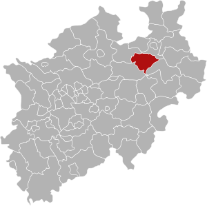
| Location of the district of Wiedenbrück in North Rhine-Westphalia | |
  |
|
The Wiedenbrück district (1939-1969: Wiedenbrück district ) was a district in eastern North Rhine-Westphalia that existed from 1816 to 1972 . The district was initially part of the administrative district of Minden in the Prussian province of Westphalia and from 1946/47 part of the North Rhine-Westphalian administrative district of Detmold . The administrative seat was Wiedenbrück and after the regional reform of 1970 Rheda-Wiedenbrück . The district was opened in 1973 as part of the North Rhine-Westphalian regional reform in the newly founded Gütersloh district .
geography
location

The area of the district Wiedenbrück extended between 51 ° 43 'and 51 ° 57' N and 8 ° 7 'and 8 ° 39' E in the east of the Westphalian lowland bay , between the Beckum mountains in the west and the Holter dunes belonging to the Senne in the east southwest of the Teutoburg Forest . The most important river was the Ems , which flows through the district from east to northwest.
The district boundary was 121 km long.
Neighboring areas
In 1972 the Wiedenbrück district bordered clockwise in the north, starting with the districts of Bielefeld , Paderborn , Lippstadt , Beckum and Warendorf .
history
The district of Wiedenbrück emerged from three historical territories, the rule Rheda , the county Rietberg and the Amt Reckenberg , which belonged to the bishopric of Osnabrück in the pre-Napoleonic period . These territories were occupied by France in 1806 . During the French period , which lasted until 1813 , the area of the Rheda rule belonged to the Grand Duchy of Berg , while the area of the Reckenberg Office and the County of Rietberg belonged to the Kingdom of Westphalia . Both Berg and Westphalen were given an administrative structure based on the French model. The canton of Rheda was formed from the rule of Rheda and the canton of Wiedenbrück from the Reckenberg office . The cantons of Neuenkirchen and Rietberg were established in the area of the County of Rietberg .
As a result of the agreements of the Congress of Vienna , all three territories fell to Prussia in 1815, which they incorporated into the administrative district of Minden of the newly created province of Westphalia in 1815 . On October 18, 1816, the Wiedenbrück district was formed from the three historical territories by ordinance of the Royal Government of Minden . The cantons founded in 1807 initially continued to exist as an administrative district, sometimes also referred to as the mayor's office . As part of the introduction of the rural community order for the province of Westphalia, the district was divided into offices in 1843 and since then has initially comprised two cities and seven offices with a total of 22 cities and municipalities:
| Administrative division 1843 | |
|---|---|
| Office | Communities |
| Clarholz | Clarholz and Lette |
| Gutersloh | Gütersloh (rural community) |
| Herzebrock | Herzebrock |
| Reckenberg | Avenwedde , Friedrichsdorf and Langenberg |
| Rheda | North Rheda -Ems and Rheda |
| Rietberg | Bokel , Druffel , Mastholte , Moese , Neuenkirchen , Rietberg , Varensell and Westerwiehe |
| Loss | Bornholte , Liemke , Österwiehe , Sende and Verl |
| free of charge | Gütersloh and Wiedenbrück |
The Clarholz office was incorporated into the Herzebrock office in 1851. The city of Rheda left the office of Rheda in 1863 and has been vacant since then. In 1867 the two communities Batenhorst and St. Vit were newly formed from parts of Langenberg . The two new communities Kattenstroth-Spexard and Lintel were formed in 1888 by hiving off from Avenwedde .
In 1910, Kattenstroth-Spexard handed over the Kattenstroth farmers to the city of Gütersloh. The remaining municipal area was named Spexard . At the same time, the rural community of Gütersloh was incorporated into the city of Gütersloh. In 1914 the new Avenwedde office , consisting of the communities Avenwedde, Friedrichsdorf and Spexard, was removed from the Reckenberg office. The office of Rheda was abolished in 1934, making the municipality of North Rheda-Ems vacant. Since then, the Wiedenbrück district has comprised four unofficial cities and municipalities as well as five offices with 23 cities and municipalities. The municipality of Liemke was renamed Schloß Holte in 1964 .
On October 1, 1969, the district became the district of Wiedenbrück.
Through the law on the reorganization of the Wiedenbrück district and parts of the Bielefeld district of December 4, 1969, the municipalities of the district were reorganized on January 1, 1970:
- Holte Castle was merged with Stukenbrock from the Paderborn district and part of Sende to form the new Holte-Stukenbrock community, which was incorporated into the Bielefeld district.
- Lette was incorporated into the town of Oelde in the Beckum district .
- The six new cities and communities Gütersloh , Herzebrock , Langenberg , Rheda-Wiedenbrück , Rietberg and Verl were formed from the remaining towns and communities in the district . At the same time, Ebbesloh , Hollen , Isselhorst and Niehorst came from the Bielefeld district to the city of Gütersloh.
- The five offices of the district were dissolved.
With the Bielefeld law of October 24, 1972, the district of Wiedenbrück was dissolved. On January 1, 1973, the towns and municipalities of the district with Harsewinkel , Holte-Stukenbrock Castle and most of the dissolved Halle (Westphalia) district were merged to form the new Gütersloh district.
Population development
The following overview shows the population of the Wiedenbrück district according to the respective territorial status. Changes to the territorial status resulted mainly from the incorporation of parts of the west wood community into the Mastholte community in 1915, parts of the Marienfeld community into the city of Gütersloh in 1939 and parts of the west wood community into the Moese community, as well as the effects of the law on the reorganization of the Wiedenbrück district and of Parts of the Bielefeld district in 1970. The numbers up to 1970 are census results and 1971 are an updated value. From 1871 and 1946, the figures relate to the local population and from 1925 to the resident population . Before 1871, the population figures were determined using inconsistent survey methods.

|
|
|
|
politics
Results of the district elections from 1946
The list only includes parties and voter communities that received at least two percent of the votes in the respective election.
Share of votes of the parties in percent
| year | CDU | SPD | FDP | DZP | BHE |
|---|---|---|---|---|---|
| 1946 1 | 62.1 | 29.9 | 4.1 | ||
| 1948 | 49.3 | 31.4 | 6.2 | 9.7 | |
| 1952 | 53.9 | 23.2 | 12.0 | 5.8 | 4.3 |
| 1956 | 50.1 | 27.6 | 10.9 | 6.4 | 4.99 |
| 1961 | 54.6 | 26.5 | 10.03 | 4.8 | 4.1 |
| 1964 | 53.8 | 30.7 | 10.6 | 3.7 | |
| 1970 2 | (58.8) | (31.8) | (9.4) |
In the 1948 election, independent candidates received 2.7% of the valid votes.
Footnotes
1 1946: additionally: KPD: 2.5%
2 1970: result not certain
District administrators
- 1816: Ludwig von Schele (acting)
- 1816–1822: Friedrich Gerstein
- 1823–1848: Johann Friedrich Malotki von Trzebiatowsky
- 1848–1868: Bernhard Bessel
- 1869–1876: Theodor Duesberg
- 1876–1881: Eduard Schmitz
- 1881–1882: Richard von Doemming (by order)
- 1882–1898: Ernst Osterrath
- 1898–1909: Willy Engelhard
- 1909–1944: Edwin Adolar Klein
- 1944–1945: Josef Bauer from Gütersloh (substitute)
- 1945–1946: Franz Kluthe (appointed)
- 1946–1961: Arnold Verhoff
- 1961–1964: Paul Hemken to Krax
- 1964–1973: Paul Lakämper
Communities
Status 1961
According to offices (area and population as of 1961):
Vacant
- Gütersloh , City (47.67 km², 52,346)
- Rheda , City (11.68 km², 13,468)
- Wiedenbrück , City (10.33 km², 14,465)
- North Rheda -Ems (16.85 km², 705; administered in personal union with Rheda)
Office Avenwedde (seat Avenwedde)
- Avenwedde (21.70 km², 8,528)
- Friedrichsdorf (0.29 km², 896)
- Spexard (13.50 km², 3,851)
Office Herzebrock (seat Herzebrock)
- Clarholz (34.01 km², 3,807)
- Herzebrock (47.18 km², 6,364)
- Lette (13.76 km², 1,748)
Reckenberg Office (Wiedenbrück headquarters)
- Batenhorst (14.63 km², 1,381)
- Langenberg (39.65 km², 4,042)
- Lintel (22.08 km², 1,231)
- Sankt Vit (10.32 km², 990)
Office Rietberg (seat Rietberg)
- Bokel (Rietberg) (17.45 km², 1,117)
- Druffel (9.72 km², 887)
- Mastholte (12.45 km², 1,705)
- Moese (15.91 km², 1,962)
- Neuenkirchen (6.84 km², 3,155)
- Rietberg , City (18.83 km², 5,500)
- Varensell (19.76 km², 2,584)
- Westerwiehe (15.02 km², 1,857)
Note: The current village of Mastholte was in the municipality of Moese and not as expected in the municipality of Mastholte.
Office Verl (seat Verl)
- Bornholte (17.81 km², 3,110)
- Liemke , renamed Schloß Holte on November 17, 1964 (26.38 km², 6,702)
- Österwiehe (14.55 km², 1,825)
- Send (23.94 km², 4,484)
- Verl (17.79 km², 5,470)
As of May 27, 1970
- Gütersloh, Stadt (111.25 km², 75,297 inh.)
- Herzebrock (79.22 km², 11,256 pop.)
- Langenberg (38.57 km², 6403 pop.)
- Rheda-Wiedenbrück , City (86.71 km², 36,682 inh.)
- Rietberg, City (110.19 km², 20,377 inh.)
- Verl (71.32 km², 15,597 pop.)
License Plate
On July 1, 1956, the district was assigned the distinctive sign WD with the introduction of the license plates that are still valid today . It was issued until December 31, 1972.
literature
- Joseph Peitzmeier: Soil - Landscape - Flora - Fauna (= monograph of the Wiedenbrück district). Wiedenbrück 1972.
- Hans Thümmler: Wiedenbrück district (= art guide of the Westphalian Heimatbund, issue 23). Munster 1947
Individual evidence
- ^ Regional Association Westphalia-Lippe (ed.); Project Westphalian History: "Royal Decree, whereby the division of the kingdom into eight departments is ordered", page 111
- ↑ Westfalenlexikon 1832-1835 . In: Landschaftsverband Westfalen-Lippe (Ed.): Reprints for the Westphalian archive maintenance . tape 3 . Münster 1978, p. xxx (reprint of the original from 1834).
- ↑ Landgemeinde -ordnung for the Province of Westphalia from October 31, 1841 (PDF; 1.6 MB)
- ^ Official Journal of the Minden Government 1844. Retrieved February 2, 2014 .
- ^ A b Wolfgang Leesch: Administration in Westphalia 1815–1945 . In: Publications of the Historical Commission for Westphalia . tape 38 . Aschendorff, Münster 1992, ISBN 3-402-06845-1 .
- ↑ Statistical representation of the district of Wiedenbrück 1863, p. 82
- ↑ Stephanie Reekers: The regional development of the districts and communities of Westphalia 1817-1967 . Aschendorff, Münster Westfalen 1977, ISBN 3-402-05875-8 , p. 212 .
- ↑ Stephanie Reekers: The regional development of the districts and communities of Westphalia 1817-1967 . Aschendorff, Münster Westfalen 1977, ISBN 3-402-05875-8 , p. 278 .
- ↑ a b Stephanie Reekers: The regional development of the districts and communities of Westphalia 1817-1967 . Aschendorff, Münster Westfalen 1977, ISBN 3-402-05875-8 , p. 239 .
- ↑ Stephanie Reekers: The regional development of the districts and communities of Westphalia 1817-1967 . Aschendorff, Münster Westfalen 1977, ISBN 3-402-05875-8 , p. 258 .
- ↑ Announcement of the new version of the district regulations for the state of North Rhine-Westphalia from August 11, 1969 in the Law and Ordinance Gazette for the state of North Rhine-Westphalia, year 1969, No. 2021, p. 670 ff.
- ^ Federal Statistical Office (ed.): Historical municipality directory for the Federal Republic of Germany. Name, border and key number changes in municipalities, counties and administrative districts from May 27, 1970 to December 31, 1982 . W. Kohlhammer, Stuttgart / Mainz 1983, ISBN 3-17-003263-1 , p. 329 .
- ↑ State Statistical Office of North Rhine-Westphalia: Municipal statistics of the State of North Rhine-Westphalia: population development 1816–1871 . Düsseldorf 1966, pp. 64-67.
- ↑ State Statistical Office of North Rhine-Westphalia: Municipal statistics of the State of North Rhine-Westphalia: Population development 1871–1961 . Düsseldorf 1964, pp. 66-69.
- ↑ State Statistical Office of North Rhine-Westphalia: The resident population in the municipalities of North Rhine-Westphalia 1970: Results of the census on May 27, 1970 . Düsseldorf 1972, p. 40.
- ↑ Statistical Yearbook for the Federal Republic of Germany 1973
- ↑ Source: respective issue of the State Statistical Office (LDS NRW), Mauerstr. 51, Düsseldorf, with the election results at the district level. The 1970 numbers are not certain.
- ^ Horst Romeyk : The leading state and municipal administrative officials of the Rhine Province 1816–1945 (= publications of the Society for Rhenish History . Volume 69 ). Droste, Düsseldorf 1994, ISBN 3-7700-7585-4 , p. 417 .
- ↑ a b Overview of the district administrators in the Gütersloh district homepage. Retrieved March 31, 2014 .
- ↑ District administrators and senior district directors, Wiedenbrück district, Paul Hemken to Krax, p. 47 (PDF) (accessed on August 27, 2020)
- ^ Paul-Lakämper-Straße ( Memento from July 19, 2011 in the Internet Archive )
Web links
- Law on the reorganization of the Wiedenbrück district and parts of the Bielefeld district of December 4, 1969

Before the founding of North Rhine-Westphalia in what is now North Rhine-Westphalia, the (rural) districts: Bilstein | Blankenheim | Bochum | Brakel | Frets | Dortmund | Duisburg | Düsseldorf | Elberfeld | Eslohe | Food | Geilenkirchen | Gelsenkirchen | Gemünd | Gimborn | Gladbach | Grevenbroich-Neuss | Gummersbach | Hagen | Hamm | Hattingen | Heinsberg (1816-1932) | Homburg | Hörde | Kempen | Krefeld | Lechenich | Lennep | Medebach | Mettmann | Mülheim am Rhein | Mülheim an der Ruhr | Neuss | Opladen | Rahden | Rheinbach | Rheinberg | Ruhrort | Schwelm | Solingen | Solingen-Lennep | Uckerath | Waldbröl | Wipperfürth
Former North Rhine-Westphalian (rural) districts: Aachen (1816–1971) | Aachen (1972–2009) | Ahaus | Altena | Arnsberg | Beckum | Bergheim (Erft) | Bielefeld | Bonn | Borken (1816–1974) | Brilon | Büren | Coesfeld (1816–1974) | Detmold | Dinslaken | Düren (1816–1971) | Düsseldorf-Mettmann | Erkelenz | Geilenkirchen-Heinsberg | Geldern | Grevenbroich | Halle (Westphalia) | Höxter (1816–1974) | Iserlohn | Jülich | Kempen-Krefeld | Cologne | Lemgo | Lippstadt | Lübbecke | Lüdenscheid | Lüdinghausen | Meschede | Minden | Moers | Monschau | Munster | Paderborn (1816–1974) | Rees | Rhein-Wupper-Kreis | Schleiden | Selfkantkreis Geilenkirchen-Heinsberg | Victories | Siegkreis | Soest (1817–1974) | Steinfurt (1816–1974) | Tecklenburg | Unna (1930–1974) | Warburg | Warendorf (1816–1974) | Wiedenbrück | Wittgenstein

Districts: Ahaus | Altena | Arnsberg | Beckum | Bielefeld | Bilstein | Bochum | Bark | Brakel | Brilon | Frets | Büren | Coesfeld | Dortmund | Ennepe-Ruhr district | Eslohe | Gelsenkirchen | Hagen | Halle (Westphalia) | Hamm | Hattingen | Herford | Hörde | Höxter | Iserlohn | Lippstadt | Lübbecke | Lüdinghausen | Medebach | Meschede | Minden | Munster | Olpe | Paderborn | Rahden | Recklinghausen | Schwelm | Victories | Soest | Steinfurt | Tecklenburg | Unna | Warburg | Warendorf | Wiedenbrück | Wittgenstein
City districts: Bielefeld | Bocholt | Bochum | Bottrop | Buer | Castrop-Rauxel | Dortmund | Gelsenkirchen | Gelsenkirchen-Buer | Gladbeck | Hagen | Hamm | Herford | Herne | Hörde | Iserlohn | Lüdenscheid | Lünen | Minden | Munster | Osterfeld | Recklinghausen | Victories | Wanne-Eickel | Wattenscheid | Witten