
Langenberg (Gütersloh district)
| coat of arms | Germany map | |
|---|---|---|
_COA.svg)
|
Coordinates: 51 ° 47 ' N , 8 ° 19' E |
|
| Basic data | ||
| State : | North Rhine-Westphalia | |
| Administrative region : | Detmold | |
| Circle : | Gutersloh | |
| Height : | 88 m above sea level NHN | |
| Area : | 38.31 km 2 | |
| Residents: | 8619 (Dec. 31, 2019) | |
| Population density : | 225 inhabitants per km 2 | |
| Postal code : | 33449 | |
| Area code : | 05248 | |
| License plate : | GT | |
| Community key : | 05 7 54 024 | |
| LOCODE : | DE LBB | |
| Community structure: | 2 districts | |
| Address of the municipal administration: |
Klutenbrinkstrasse 5 33449 Langenberg |
|
| Website : | ||
| Mayoress : | Susanne Mittag (UWG) | |
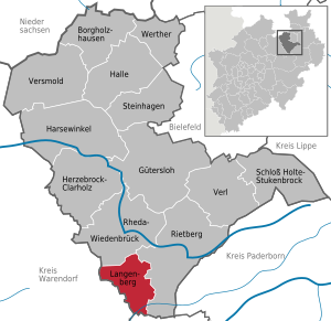
| Location of the municipality of Langenberg in the Gütersloh district | ||
  |
||

Langenberg is a municipality in the district of Gütersloh in the northeast of the German state North Rhine-Westphalia .
geography
Geographical location
The municipality of Langenberg is located in the southern part of the Gütersloh district on the foothills of the Oelder and Stromberg mountains. The closest larger cities in the north are Rheda-Wiedenbrück in 7.5 km and Gütersloh in 18 km, and in the south Lippstadt in 12 km. The city of Paderborn to the east is 36 km away.
The municipality is traversed in a north-easterly direction by Eusternbach and Fortbach , which fall directly or via the Grubebach into the Ems , as well as Landgraben, Brandgraben, Kleybach, Schulgraben, Bergwiesenbach and Kaltestroth, which flow in a northeast to southeast direction and fall into the Glenne . This leaves the area in a south-westerly direction and later flows into the Lippe .
The highest point in the municipality is at 112 m above sea level. NN in the westernmost municipality at 51 ° 47 ′ 7 ″ N , 8 ° 15 ′ 34 ″ E , the lowest at 51 ° 43 ′ 39 ″ N , 8 ° 20 ′ 2 ″ E is the outflow of the Glenne from the municipality in the south at 75 m above sea level NN .
geology

The subsoil of the municipality is made up of river and lake deposits from the end of the Holstein warm period and meltwater sediments with interim sediments of marl from the Saale glacial period . In the low-lying areas of the tributaries of the Lippe and Ems, gravel , sand and silt with built-on bank walls, sand loess , drifting sand and dunes from the Vistula glaciation and the post-ice age are stored . The underlying solid rock subsoil is formed from almost exactly horizontal marl stones, marl, marl limestone and limestone from the Middle Ages . Under this layer is a plinth made of folded Devonian and Carboniferous rocks .
The entire eastern part of the municipality lies in the lowlands of the Ems and Lippe. Gleye formed there from sandy to sandy-loamy river and stream deposits with high groundwater . These are primarily used as grassland. In the east, gleyes are predominant, which are influenced by waterlogging in the topsoil (pseudogley gleye). In the south of the municipality, low groundwater levels have created nutrient-poor heather soils ( podsoles ). Gley podsoles have formed when the groundwater level is higher. These are mainly used for arable farming. In the western part of Langenberg, glacial till is predominant, from which clay-rich soils arose. Because of the low water permeability, waterlogging can occur right down to the topsoil. These soils are often used for forestry, as grassland and, after drainage measures, also as arable land.
Langenberg is moderately to well suited for the use of geothermal heat sources by means of a geothermal probe and heat recovery through heat pump heating (see the adjacent map).
Expansion and use of the municipal area
_-_land_utilization.svg)
The community, classified as a large rural community, covers an area of 38.31 km². The predominant part consists of about 76.4% agricultural area, followed by settlement and traffic areas, together about 14.1%. The largest extension in north-south direction is around 9.2 km, in east-west direction around 7.6 km.
| Area according to type of use |
Agricultural area |
Forest area |
Building, open and operational space |
Traffic area |
Surface of water |
Sports and green space |
other use |
|---|---|---|---|---|---|---|---|
| Area in km² | 29.27 | 2.58 | 3.55 | 1.87 | 0.80 | 0.21 | 0.02 |
| Share of total area | 76.40% | 6.73% | 9.27% | 4.88% | 2.09% | 0.55% | 0.05% |
Neighboring communities
| Oelde | Rheda-Wiedenbrück | |
| Wadersloh |  |
Rietberg |
| Lippstadt |
Langenberg borders on five municipalities: in the north on Rheda-Wiedenbrück , in the east on Rietberg (both in the district of Gütersloh), in the south on Lippstadt ( district of Soest ) and in the west on Wadersloh and in the north-west on Oelde (both in the district of Warendorf ).
Community structure

The municipality of Langenberg has been divided into the districts of Benteler and Langenberg since the regional reform in 1970 . This division is only historical and justified in built-up areas, an administrative subdivision is not derived from it. Furthermore, the two farmers Selhorst (zu Langenberg) and Allerbeck (zu Benteler) belong to the community.
In recent years, Selhorst has significantly increased its settlement area through new development areas and can now be described more as a separate town.
The population of the municipality is given as of January 1, 2006 for the district Langenberg with 6,262 and for Benteler with 2,249. The resulting total number of inhabitants differs from the information provided by the State Statistical Office (see population development ).
climate

Langenberg belongs to the moderate climatic zone of Central Europe. It is in the range of the sub-Atlantic maritime climate. The winters are mostly mild under the influence of the Atlantic and the summers are moderately warm.
Due to the location in the sub-Atlantic maritime climate, a humid climate prevails all year round with relatively evenly distributed rainfall. Since precipitation data are not available for Langenberg, values are given for the Rietberg station about 10 km away. The long-term average precipitation there is 772 mm per year. This means that more precipitation falls than the German average (700 mm).
Temperature values are also not available for Langenberg. At a weather station in neighboring Rheda-Wiedenbrück , an average temperature of 11.1 ° C was measured between 2002 and 2006.
→ See also: Climate in Ostwestfalen-Lippe
history

Langenberg is mentioned for the first time in 1180 in historical documents in which the small settlement was assigned to the Prince Diocese of Osnabrück . Since that time Langenberg has been administered by the Drosten and officials from Wiedenbrück ( Reckenberg Office ). This assignment persisted even after the Congress of Vienna in 1815, although Prussia created counties as new administrative units in its new Westphalian regions. The assignment was only dissolved in 1970.
Benteler was first mentioned in a document as early as 1130 and thus probably the older part of the community. Until 1970 it belonged to the Wadersloh office , which was created in 1816 by the Prussian administrative division.
The community was largely agricultural until well into the middle of the 19th century. Although the road from Wiedenbrück to Lippstadt had already been completed in 1828, the first industrial settlement did not take place until 1845 with the establishment of a brewery (today's Hohenfelde private brewery).
religion

Historically, the majority of citizens are of the Roman Catholic faith, while a smaller number are of the Protestant faith. Believers from other religions can be assumed. There are two Catholic and one Protestant congregations in the Langenberg area.
Since only the political boundaries were redrawn during the parish reorganization, the Catholic parish in Langenberg in the Reckenberg Pastoral Association is assigned to the Archdiocese of Paderborn and the Catholic parish in Benteler in the Beckum dean's office is assigned to the Diocese of Münster .
Exact data are not available for the community, as religious affiliation is one of the personal data worth protecting and as a result is not published, not even in aggregated form.
In Langenberg there are numerous church associations and other offers for young people organized by the community. The Catholic Young Community Langenberg (KJG) for children and young people was founded in 1974 in the parish of St. Lambertus and St. Laurentius Langenberg and today has around 130 members.
Incorporations
As part of the North Rhine-Westphalian territorial reform in the course of the implementation of the "Law for the reorganization of the Wiedenbrück district and parts of the Bielefeld district" of December 4, 1969, the previously independent communities Benteler ( Liesborn-Wadersloh , Beckum district ) and Langenberg ( Office Reckenberg , Kreis Wiedenbrück ) merged on 1 January 1970 on the new church Langenberg. Individual parcels from the communities of Batenhorst (Reckenberg Office), Bokel and Mastholte (both Rietberg Office ) were incorporated into the new municipality .
Population development
_-_population_development.svg)
The following overview shows the population of the municipality of Langenberg according to the respective territorial status, in some years also according to the current territorial status. The figures are census results up to 1970 and 1987 and from 1975 official updates by the State Office for Data Processing and Statistics . The figures from 1975 to 1985 are estimated values, the figures from 1990 are extrapolations based on the results of the 1987 census. From 1871 and 1946, the figures relate to the local population , from 1925 to the resident population and from 1985 to the population at Location of the main residence . Before 1871, the population figures were determined using inconsistent survey methods.
Langenberg according to the territorial status at that time
| year | Residents |
|---|---|
| 1818 (Dec. 31) | 1051 |
| 1831 (December 3) | 1224 |
| 1837 (Dec. 3) | 1257 |
| 1843 (December 3) | 1376 |
| 1849 (December 3) | 1427 |
| 1852 (December 3) | 1448 |
| 1858 (Dec. 3) | 1559 |
| 1867 (December 3) | 1535 |
| 1871 (December 1) | 1542 |
| year | Residents |
|---|---|
| 1885 (December 1) | 1670 |
| 1895 (December 1) | 1826 |
| 1905 (December 1) | 1872 |
| 1925 (June 16) | 2031 |
| 1933 (June 16) | 2323 |
| 1939 (May 17) | 2681 |
| 1946 (Oct. 29) | 3456 |
| 1950 (Sep 13) | 3899 |
| 1961 (June 6) | 4042 |
Langenberg according to today's territorial status
| year | Residents |
|---|---|
| 1939 (May 17) | 3867 |
| 1950 (Sep 13) | 5610 |
| 1961 (June 6) | 5681 |
| 1970 (May 27) | 6403 |
| 1974 (June 30) | 6647 |
| 1975 (Dec. 31) | 6580 |
| 1980 (Dec. 31) | 6507 |
| 1985 (Dec. 31) | 6638 |
| year | Residents |
|---|---|
| 1987 (May 25) | 6797 |
| 1990 (Dec. 31) | 7026 |
| 1995 (Dec. 31) | 7719 |
| 2000 (Dec. 31) | 8126 |
| 2005 (Dec. 31) | 8186 |
| 2007 (Dec. 31) | 8196 |
| 2012 (Dec. 31) | 8113 |
Since the formation of today's municipality in 1970 until 2007, the population has grown by around 28% compared to the state of North Rhine-Westphalia - but on average for all municipalities classified as "large rural municipality". A particularly high increase in population was recorded between 1990 and 1995, which can be explained in particular by the ethnic repatriates who moved there.
The number of inhabitants is given as 8530 by the municipal administration on January 1, 2008, in contrast to the figures from the State Statistical Office listed above.
politics
Langenberg is part of the Gütersloh III state electoral district , in which Michael Brinkmeier (CDU) was elected as a direct candidate for the third time in a row in the 2010 state elections . At the federal level, Langenberg belongs to the Gütersloh constituency , in which Ralph Brinkhaus (CDU) was elected as a direct candidate in 2009.
Municipal council
Langenberg municipal council in 2014
- Greens: 2
- SPD: 3
- UWG: 9
- FDP: 1
- CDU: 11
The municipal council currently has 26 members from five parties. Then there is the mayor.
The following table shows the local election results since 1975:
| 2014 | 2009 | 2004 | 1999 | 1994 | 1989 | 1984 | 1979 | 1975 | ||||||||||
|---|---|---|---|---|---|---|---|---|---|---|---|---|---|---|---|---|---|---|
| Political party | Seats | % | Seats | % | Seats | % | Seats | % | Seats | % | Seats | % | Seats | % | Seats | % | Seats | % |
| CDU | 11 | 41.67 | 11 | 40.64 | 12 | 47.21 | 15th | 55.98 | 15th | 51.29 | 14th | 49.39 | 16 | 57.58 | 15th | 54.81 | 20th | 70.54 |
| UWG 1 | 9 | 33.92 | 9 | 32.75 | 7th | 25.95 | 5 | 18.96 | 2 | 6.89 | 1 | 6.54 | - | - | - | - | - | - |
| SPD | 3 | 12.38 | 3 | 12.60 | 5 | 17.22 | 5 | 21.27 | 9 | 30.82 | 10 | 35.94 | 9 | 34.66 | 10 | 36.70 | 6th | 23.97 |
| FDP | 1 | 4.86 | 2 | 8.80 | 1 | 5.23 | - | - | 0 | 4.56 | 2 | 8.58 | 2 | 7.76 | 2 | 8.50 | 1 | 5.49 |
| Green | 2 | 7.17 | 1 | 5.21 | 1 | 4.40 | 1 | 3.79 | 1 | 6.44 | - | - | - | - | - | - | - | - |
| Total 2 | 26th | 100 | 26th | 100 | 26th | 100 | 26th | 100 | 27 | 100 | 27 | 100 | 27 | 100 | 27 | 100 | 27 | 100 |
| voter turnout | 59.98 | 58.77 | 66.41 | 67.44 | 85.78 | 76.44 | 76.80 | 77.87 | 89.79 | |||||||||
1 Independent community of voters, 2 without taking into account rounding differences
mayor
The incumbent mayor has been Susanne Mittag ( UWG ) since 2004 , she was elected in a run-off vote in 2004 with 62.1% of the votes cast and confirmed in office with 88.38% of the votes in 2009 and 75.12% in 2014. Between 1999 and 2004 Annegret Schütze was mayor (also UWG), she was elected with 52.5% of the votes cast.
Coat of arms, seal and flag

The municipality of Langenberg has coats of arms, seals and flags.
- Description of coat of arms
- In silver (white) in front two blue cornflowers standing on top of each other with silver (white) clusters, behind a blue flank pole.
The two flowers indicate the emergence of the new community from the local centers of Langenberg and Benteler, the union of which is to be reflected in the flank pole, as a link to the north-south axis. The coat of arms was approved by a certificate from the District President in Detmold on December 15, 1976.
- Description of the seal
- The seal contains the inscription "GEMEINDE LANGENBERG" at the top and "KREIS GÜTERSLOH" at the bottom
- Description of the flag
- The banner is striped lengthways from blue-white-blue in a ratio of 1: 2: 1 with the coat of arms of the municipality in the upper half.
- The flag is blue-white-blue in a ratio of 1: 2: 1 with the coat of arms of the municipality in the white field.
The flag was approved on December 15, 1977.
Community partnerships
The community of Neuzelle in Brandenburg near the border with Poland has been a partner community of Langenberg since 1993. There is a lively exchange, especially meetings of young people from both communities are organized, in which young people from Neuzell's twin town Zielona Góra also take part.
Culture and sights
theatre
The Langenberger Laienspielschar has brought a play to the stage almost every year since it was founded in 1968 (there were no performances in 1977 and 1978). Between 1989 and 1999, the pieces were also performed six times per winter season in Bad Westernkotten . While the performances in Langenberg were performed on the stage of the Drei-Kaiser-Saal in a restaurant for years, the Brinkmann School auditorium has been in use since 2003 - as it did until 1970.
museum
The Benteler Heimatstube has existed since 1967 . It was initially located in a teaching material room in the school building in Benteler, and since 1984 the Benteler Heimatverein, which is responsible for the Heimatstube, has leased rooms on Stukendamm. Handicraft tools from cobblers , wheelwright and clog makers , agricultural tools for flax processing and harvesting, household tools (dairy farming, laundry and textiles), as well as the inventory of a classroom are shown. Special exhibitions by local artists in the fields of painting and carving are organized at irregular intervals. The Heimatstube can be visited by prior arrangement.
Buildings
The Langenberg station was built in the 1887th Passenger traffic was stopped in 1979, and freight traffic on the line in 1995. The structure has remained unchanged since then and the track systems are still largely in place (as of March 2007).
The Geissel estate was first mentioned in a document in 1231. The estate is a listed building and is located in one of the largest forest areas in the Gütersloh district. The half-timbered houses and the surrounding gardens date from the 18th century.

The Cafe "Zur Linde" is a more than 400 years old inn on Kirchplatz in Langenberg. The half-timbered building is marked above the entrance 1649. But as early as 1567 it can be found in the parish's account books, as rent for a guest room was paid on church property. The house housed a brewery, distillery and bakery. In 1997 the café was reopened in the renovated building.

The Catholic parish church of St. Lambertus and St. Laurentius Langenberg was first mentioned in a document in 1234. The west tower was built around 1200 in the Romanesque style. The church itself is late Gothic. Today's central nave and tower spire are from the 15th to 16th centuries. From 1892 to 1894, neo-Gothic aisles were added. Inside the church there is a Romanesque font from the 13th century. The crucifixion group, the Radiant Madonna and the tabernacle were brought into the church in 1515–1523.
The church of St. Antonius Benteler was built from 1856-1859 as a hall church with a tower in the west made of bricks. In 1912–1914 the transept, south-east tower, choir and sacristy were added. The pulpit, the high altar and the side altars come from the Wiedenbrück school . The clockwork of the old tower clock can be seen in front of the church.
In the Evangelical Peace Church there is a bell from 1860. It is attributed to the foundryman Heinrich Ludwig Lohmeier and is now a listed building.

Other buildings worth seeing are the old Lippentrupper school and the former bailiwick.
Parks
Langenberg does not have designated parking areas.
Natural monuments
The community has three oaks that have been designated as natural monuments by the Gütersloh district. The oaks are all located in the Langenberg district, two of which are along the R25 cycle path. There are no nature reserves in the municipality.
societies
Langenberg has an extremely well-developed club structure. There are more than 60 associations, so statistically there is one association for about 140 inhabitants.
Sports
There are two general sports clubs in the municipality. The SV Grün-Weiß Langenberg was founded in 1928 and today has over 700 members. In the course of the club's history, a merger with the second major sports club, SV 56 Benteler, was considered several times ; however, the merger could always be averted. SV 56 Benteler was founded on May 1st, 1956 and today has over 400 members. The first team in football plays in the district league A.
Each of the two districts has its own shooting club. The St. Lambertus Schützenbruderschaft Langenberg eV was founded in 1871. In 1999 an own shooting department was founded. What is unusual here is that the trophy for the best company in comparative shooting since 1951 is awarded with 16-ender antlers as a trophy. The St. Antonius Schützenbruderschaft Benteler was founded in 1900 as a warrior and militia association. The association has more than 800 members and was able to acquire its own fairground in 1999.
In addition, there is a breeding, riding and driving club, a tennis club, a gymnastics club, a diving club, as well as a senior football club, a disabled sports community, an indoor sports club and a DLRG local group. There are also six carrier pigeon clubs in Langenberg.
music
The community is also very active musically. In addition to a church choir, a youth choir, a children's choir (with several age groups) and a large gospel choir, there are two folk dance groups, two marching bands, a brass band (with a youth section) and two men's choirs.
Regular events
In March the community celebrates the Langenberg Spring . The highlights of the community's social life are the shooting festivals in the districts. The shooters in Benteler celebrate in May, the shooters in Langenberg in July. In September there is a big Lambertuskirmes on the Festwiese at the Volksbank . On the 1st of Advent in Langenberg there is the Nikolaustage , a Christmas market around the Lambertus Church .
With the exception of the summer months, the Heimatverein Langenberg offers a Low German Krink evening every month . In addition, many clubs offer (sometimes monthly) offers, such as bike tours, carnival events, trips together or sports tournaments.
Culinary specialties
The products of the Hohenfelde private brewery are known regionally. In addition to a typical regional Pils, the Lappmann's Dunkel, which has been brewed according to an almost unchanged old recipe since 1994, and the spirit Hohenfelder Weizen Bierbrand with 40% alcohol are particularly worth mentioning. For the state horticultural show in neighboring Rietberg , the Hohenfelde brewery produced Leos Bernstein beer .
Infrastructure and economy
traffic
Rail transport
There has been no rail passenger transport in the municipality since 1979. The disused section of the Rhedaer Bahn, which formerly ran from Rheda to Lippstadt, ends in Langenberg .
Bus transport
Langenberg is accessed by the regional bus. Line 70 runs every hour between Rheda-Wiedenbrück and Lippstadt via Langenberg and is therefore also a connection between the core town and the Benteler district.
Road traffic
Langenberg is on the B 55 and is the starting point for the B 58 . The next motorway is the A 2 , approx. 10 km away.
Air traffic
The nearest airport is Paderborn / Lippstadt Airport , around 40 km away.
Bicycle traffic
The BahnRadRoute Hellweg-Weser runs through Langenberg . In addition, three inner-community bike paths are signposted. These are the R25 over the Langenberger Heights with a length of 14 km (past the highest point of the municipality), the R26 in the southern district with a length of 20 km and the R27 around Langenberg cycle path , which covers almost all parts of the municipality with a length of 39 km touched.
Foot traffic
Langenberg has five hiking trails with lengths between seven and eleven kilometers and three Nordic walking routes with lengths between six and twelve kilometers.
media
Print media
Due to its special location at the intersection of three districts, four daily newspapers are represented in Langenberg. The Neue Westfälische with a regional section and a local edition of the Westfalen-Blatt appear daily, Monday to Saturday . Both newspapers get their coat from their respective coat editorial offices in Bielefeld. Also available with local coverage are Die Glocke from neighboring Oelde and Der Patriot from neighboring Lippstadt from Monday to Saturday .
Radio and television
Langenberg belongs to the reporting area of the regional studio Bielefeld of the WDR and of Radio Gütersloh , which it covers in the reporting as local radio.
Public facilities
The Langenberg volunteer fire brigade consists of the Langenberg and Benteler fire engines . The community does not have an indoor or outdoor pool, so in the summer season, if the weather is good, a free so-called "bathing bus" to the outdoor pool in Wiedenbrück is offered three times a week for children and young people. The closest hospitals are in Rheda-Wiedenbrück and Lippstadt.
education
The community offers a primary school with two locations, each in Langenberg and Benteler, as well as a community school in Langenberg. For other types of school, offers from the surrounding cities and communities must be used.
In 2007, a total of 651 pupils were taught at Langenberg schools with 38 teachers, 65% of them at primary schools and 35% at secondary schools.
Langenberg is a member of the Reckenberg-Ems Adult Education Association.
Established businesses

Langenberg is characterized by an extremely medium-sized and diversified economic structure, large companies are not based. The outstanding branch of the economy is the manufacturing industry , in this sector 30.2% of the employees subject to social security contributions work in Langenberg. Langenberg is the seat of the regionally famous Hohenfelde private brewery .
Personalities
Sons and daughters of the church
- Karl Hoffmann (1887–1968), Roman Catholic theologian, Rector General of the Pallottine Order
- Josef Voss (1937–2009), auxiliary bishop in the diocese of Münster
- Hubert Doppmeier (1944–1992), politician
- Thomas Euting (* 1952), television journalist and editor
Other personalities
- Ernst Meurin (1885 – after 1965), German author and district home administrator from Wiedenbrück
literature
- Heimat-Jahrbuch Kreis Gütersloh . Flöttmann, Gütersloh 1982, ISSN 0177-8439 .
- Wilhelm Kampmeier: Home and court history of Benteler . Langenberg, 1997.
- Theres Sudbrock: Regional Identity in the Gütersloh District / The Effects of Regional Reform 1973 . Publishing house for regional history, ISBN 978-3-89534-498-5 .
- Franz Flaskamp: The oldest soul status lists [1651 ff.] Of the parish of Langenberg . Regensberg, Münster 1946.
- Bernhard Bartels furniture factory . B. Bartels furniture factory, Langenberg 1935.
- Matthias E. Borner: Pölter, Plörre and Pinöckel - basic vocabulary for survival in Gütersloh. Verlagsunion Vox Rindvieh, 2004, ISBN 3-00-014249-5 .
- Matthias E. Borner: Pölter, Plörre and Pinöckel 2 - advanced vocabulary for inquisitive new residents in Gütersloh. Verlagsunion Vox Rindvieh, 2006, ISBN 3-00-018120-2 .
Web links
- Langenberg (Gütersloh district) in the Westphalia culture atlas
Individual evidence
- ↑ Population of the municipalities of North Rhine-Westphalia on December 31, 2019 - update of the population based on the census of May 9, 2011. State Office for Information and Technology North Rhine-Westphalia (IT.NRW), accessed on June 17, 2020 . ( Help on this )
- ^ Geological Service North Rhine-Westphalia: Geoscientific description of the municipality of Langenberg ( Memento from August 4, 2012 in the web archive archive.today )
- ↑ Geological Service NRW: Using geothermal energy - Geothermal study provides planning basis ( Memento from September 14, 2005 in the Internet Archive ) (PDF; 369 kB)
- ↑ a b c d State Office for Data Processing and Statistics North Rhine-Westphalia: Municipal profile Langenberg ( Memento from May 5, 2008 in the Internet Archive )
- ↑ a b Website of the municipality of Langenberg: Municipality portrait - general statistical data (archive version) ( Memento from April 30, 2007 in the Internet Archive )
- ↑ Website of the Langenberg community: Churches section (archive version) ( Memento from August 25, 2007 in the Internet Archive )
- ^ Religion Online - Membership Numbers
- ^ KJG St. Lambertus Langenberg
- ↑ Martin Bünermann: The communities of the first reorganization program in North Rhine-Westphalia . Deutscher Gemeindeverlag, Cologne 1970, p. 110 .
- ↑ State Statistical Office of North Rhine-Westphalia: Municipal statistics of the State of North Rhine-Westphalia: population development 1816–1871 . Düsseldorf 1966, p. 210.
- ↑ State Statistical Office of North Rhine-Westphalia: Municipal statistics of the State of North Rhine-Westphalia: Population development 1871–1961 . Düsseldorf 1964, pp. 430-431.
- ↑ State Statistical Office of North Rhine-Westphalia: The resident population in the municipalities of North Rhine-Westphalia 1970: Results of the census on May 27, 1970 . Düsseldorf 1972, p. 46.
- ^ State Office for Data Processing and Statistics North Rhine-Westphalia: Special series on the 1987 population census in North Rhine-Westphalia, Volume 1.1: Population, private households and employed persons. Düsseldorf 1989, p. 110.
- ^ State Office for Data Processing and Statistics North Rhine-Westphalia: State database North Rhine-Westphalia
- ^ State Office for Data Processing and Statistics North Rhine-Westphalia: State database North Rhine-Westphalia; Election results for the municipality code 05754024
- ↑ a b State Office for Data Processing and Statistics North Rhine-Westphalia: Results of the local elections
- ↑ Vote Manager community Langenberg
- ↑ a b c main statute of the community of Langenberg (PDF) ( page no longer available , search in web archives ) of December 21, 1984 in the version of the 11th amendment of December 14, 2009
- ↑ Langenberg on kommunalflaggen.de
- ^ Laienspielschar Langenberg - History section
- ^ Website of the Heimatverein
- ^ Westfälische Localbahn eV ( Memento from May 22, 2014 in the Internet Archive )
- ↑ Café zur Linde
- ↑ Website of the municipality of Langenberg: Section clubs (archive version) ( Memento from August 25, 2007 in the Internet Archive )
- ^ SV Grün-Weiß Langenberg 1928 eV
- ^ SV 56 Benteler eV
- ↑ St. Lambertus Schützenbruderschaft Langenberg eV
- ↑ St. Antonius-Schützenbruderschaft Benteler
- ↑ Archived copy ( Memento from March 4, 2016 in the Internet Archive )
- ↑ a b Website of the community of Langenberg: Freizeitkarte (PDF) ( page no longer available , search in web archives )