
Lippe (river)
| lip | ||
.png) Course of the lip ( interactive map ) |
||
| Data | ||
| Water code | EN : 278 | |
| location | Germany | |
| River system | Rhine | |
| Drain over | Rhine → North Sea | |
| source | in Bad Lippspringe 51 ° 46 ′ 53 ″ N , 8 ° 49 ′ 21 ″ E |
|
| Source height | approx. 140 m above sea level NHN | |
| Spring discharge |
MQ |
740 l / s |
| muzzle | near Wesel in the Rhine Coordinates: 51 ° 39 '2 " N , 6 ° 36' 16" E 51 ° 39 '2 " N , 6 ° 36' 16" E |
|
| Mouth height | 15.1 m above sea level NHN | |
| Height difference | approx. 124.9 m | |
| Bottom slope | approx. 0.57 ‰ | |
| length | 220.1 km | |
| Catchment area | 4,889.912 km² | |
| Discharge at the gauge Schermbeck 1 A Eo : 4783 km² Location: 22.4 km above the mouth |
NNQ (11/01/1964) MNQ 1965–2007 MQ 1965–2007 Mq 1965–2007 MHQ 1965–2007 HHQ (01/04/2003) |
13 m³ / s 16.7 m³ / s 44.1 m³ / s 9.2 l / (s km²) 248 m³ / s 452 m³ / s |
| Left tributaries |
Pader , Alme , Ahse , Seseke (more see below ) |
|
| Right tributaries |
Glenne , Stever (others see below ) |
|
| Big cities | Paderborn , Hamm | |
| Medium-sized cities | Lippstadt , Werne , Lünen , Haltern am See , Dorsten , Wesel | |
| Residents in the catchment area | 1,874,000 | |
| Navigable | Parallel channel: * up to Datteln class Vb ( WDK ); * to Uentrop Euroschiff ( DHK ) |
|
 The lip near Lünen |
||

_(10585406215).jpg)


.jpg)

The Lippe is a 220 km long right tributary of the Rhine in North Rhine-Westphalia with a catchment area of 4,889.9 km².
In 2018, the Lippe received the River Landscape of the Year award .
At the Hamm gauge , the Lippe has an average discharge of 23 m³ / s; this increases to 45 m³ / s up to the mouth near Wesel .
Surname
The name of the lip has been in the Latin form Lupia since (late) antiquity as a result of the expansion of the Roman Empire into the Germanic area by the contemporary historiographers and authors ( Strabon , Velleius Paterculus , Pomponius Mela , Tacitus , Claudius Ptolemy and Cassius Dio ) handed down. For the period from 496 to 506 the name appears in the geographer of Ravenna (4.17) in the form Lippa . In the early and high medieval period that followed, the river name was closely linked to numerous place names along the river, such as the Lippiogyspringiae curte document for the source location Lippspringe in 780 and a document from 1129 de Lippa for Lippstadt . Lippborg indicates a castle (Borg) on the Lippe and is first mentioned in 1189.
As the basic form of today's German name and the ancient Latin form, the Germanic * Lipjā is to be used with the later consonate mixture -pp- . According to a more frequently presented view, the Roman form is an official folk etymological adaptation of the Germanic name to the Latin lexeme Lupus for "wolf". Albrecht Greule counters this view that it cannot be ruled out that a local dialectal Germanic variant of the Lippe name (presumably the lower reaches region) served as a template for the Latin form from Germanic * Lipjō . It follows that both possible forms Germanic * Lupjō and * Lipjō represent weak j-derivatives of verbs that describe the flow characteristics of the lip as by Germanic (* s) leup-a- , Old English slūpan , Middle Low German sleūpen with the meaning of "slip , to sneak". Furthermore, there are comparative evidence such as the Old High German sliofan for "schlüfen" as a gloss to the Latin lūbricus "smooth, slippery" and Germanic * (s) leip-a- for "grind" or "glide" and Old English slipor for "smooth", which can be put "slippery" in Greek olibrōs . Greule explains the disappearance of the initial s- with the ease of speaking by avoiding the aggravating consonant groups / sl- -pj- /> / l- -pj- /.
geography
course
source
The Lippe rises in the core town of Bad Lippspringe at the western foot of the Egge Mountains . The Lippequelle , a karst spring with an average discharge of 0.74 m³ / s, is located at the southern end of the Arminius Park between the Lippe Institute in the west and the congress center in the east.
Upper course
Still in the city center, the 1.85 km long Jordan flows towards the Lippe , whose source is 420 m northeast of the Lippe spring and which forms the lower reaches of the 6.7 km long Thunebach . The Lippe flows in a south-westerly direction to Paderborn , where it absorbs the water from Beke , Pader , Alme and Thune . At the confluence of the Lippe and Pader in Neuhaus Castle , the Pader has about three times the amount of water in relation to the Lippe. The Alme joins a few hundred meters downstream. At 59.1 km, it is more than five times as long as the Lippe up to this point (11.2 km). This makes the Lippe one of the river systems whose main strand is not the named source branch, but is formed by tributaries ( main hydrological branch: Pader, longest flow path: Alme).
In the Sande district of Paderborn , the water of the river has been dammed to the Lippesee since 1989 , but has been led around the lake for the most part in the Lippesee flood since 2005 for the purpose of renaturation . The Lippe continues to flow in a westerly direction through the southern part of the Westphalian Bay .
Middle course
Shortly after Lippstadt , the Glenne joins from the north . Then the Lippe reaches Lippborg with the right tributary Quabbe . The bird population has increased since the renaturation. The area at this tributary can be seen from the elevated, crossing federal highway 475 .
In Hamm , the largest tributary in the city, the Ahse is fed through a culvert under the Datteln-Hamm Canal . The mouth of the Ahse was relocated to the east with the construction of the canal from the city center. In the further course the Lippe passes Werne and Bergkamen as well as Lünen , where it takes up the Seseke . In the Bergkamen district of Rünthe , federal road 233 crosses the river.
Lower course
After leaving the city of Lüner, the Lippe forms the border between the municipalities of Selm (- Bork ) on the right and Waltrop on the left, and still between Olfen (near the Lippe is the Vinnum district ) and Datteln and Ahsen on the left. Only in the town of Haltern am See below Ahsen does the Lippe flow through just one place on both sides. To the right above the city center is the district of Hullern , to the left is Flaesheim and, opposite the city center, Hamm-Bossendorf . In Haltern, one of its largest tributaries flows to the Lippe from the right, the Stever .
While still in the Haltern area, the Lippe continues to flow into the Lippramsdorf district . Shortly before, it had already reached the city area of Marl on the left , which, however, is flown through or touched almost only on the northern edge. Only the statistical district (Hamm) - Sickingmühle (residential areas Herne and Sickingmühle , Lippramsdorf opposite) and the Marl chemical park with the residential areas Ölde and Lippe of the former Lippe community are located directly on the river . It then flows through Dorsten (together with districts), Schermbeck (together with Gahlen ) and Hünxe .
As a result of the land consolidation procedure , which was completed in 2017, a total of eleven river loops are to be created in the following years between the weir in Lünen-Lippholthausen , Buddenburg and the weir Dahl in the area of Selm-Bork; the lip would be around 2.5 km longer. The aim is also to bring the lip - further - into "good condition", i. H. a near-natural water structure for the further development of the flora and fauna on the water, combined with more valuable leisure and relaxation.
muzzle
Finally, the Lippe flows directly southwest of Wesel and shortly after crossing under the Bundesstraße 58 in the immediate vicinity of the urban Rhine port of Wesel into the Rhine flowing there from the south .
Tributaries
Graphic representations
The following graphics are arranged in orographic order from bottom (source) to top (mouth).
Longest tributaries
The ten longest tributaries of the Lippe (length over 15 km) are:

Tributaries with the largest catchment area
The twelve tributaries of the Lippe with the largest surface catchment area (at least 75 km²) are:

Most water-rich tributaries
The following is the MQ balance of the Lippe tributaries, which can be reliably determined by level measurements (see level values here ):
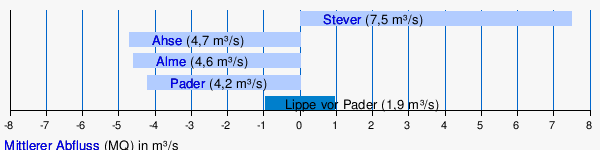
It can be seen in particular that the Pader and Alme rivers, which flow shortly after one another, are the actual main rivers of the Lippe upper reaches.
Main tributaries
All tributaries of the Lippe with at least 30 km² catchment area and those with more than 10 km² above Pader and Alme are listed below:
| Surname | page | Length (km) |
EZG (km²) |
Lippe- km (before mouth) |
Villages on the river (*: source location / location near the source) |
Muzzle (at) |
DGKZ |
|---|---|---|---|---|---|---|---|
| Thunebach (including Jordan) | right | 6.7 | 17.6 | 218.8 | snakes | Bad Lippspringe | 278-12 |
| Steinbeke | Left | 10.5 | 25.4 | 218.3 | Bad Lippspringe | 278-14 | |
| Beke | Left | 17.6 | 49.9 | 214.6 | * Altenbeken | PB - Marienloh | 278-16 |
| Pader | Left | 4.5 | 60.7 | 209.6 | * Paderborn | PB - Neuhaus Castle | 278-18 |
| Alme | Left | 59.1 | 763.0 | 208.8 | * Brilon - Alme , Büren | PB - Neuhaus Castle | 278-2 |
| Tuna | right | 24.5 | 90.7 | 204.7 | Schlangen- Kohlstädt , Schlangen , PB - Sennelager | PB - sands | 278-32 |
| Heder | Left | 11.8 | 83.9 | 191.8 | * Salzkotten- Upsprunge , Salzkotten , Salzk.- Verne | Salt threshold | 278-372 |
| Geseker Bach | Left | 10.0 | 130.2 | 186.6 | * Geseke | Lippstadt - Garfeln | 278-38 |
| Glenne | right | 45.5 | 324.6 | 170.3 | Delbruck | Lippstadt - Cappel | 278-4 |
| Gieseler | Left | 12.9 | 160.2 | 168.9 | * Erwitte - Eikeloh , Erwitte- Bad Westernkotten | Lippstadt - Hellinghausen | 278-52 |
| Trotsbach | Left | 20.7 | 55.0 | 163.5 | Anröchte - Altengeseke | Lippstadt - Eickelborn | 278-56 |
| Quabbe | right | 16.6 | 74.2 | 146.9 | Lippetal - Lippborg | 278-58 | |
| Ahse | Left | 50.0 | 441.0 | 126.3 | * Möhnesee - Echtrop , Bad Sassendorf , Lippetal - Oestinghausen | Hamm | 278-6 |
| Wiescher Bach | Left | 11.1 | 37.0 | 118.6 | * Hamm - Rhynern | Hamm - Herringen | 278-72 |
| Beverbach | Left | 8.3 | 33.0 | 109.2 | * Hamm - Herringen | Bergkamen - Rünthe | 278-732 |
| Horns | right | 12.6 | 42.4 | 109.0 | * Herbern | Werne | 278-74 |
| Seseke | Left | 31.9 | 319.3 | 96.9 | * Werl - Holtum , south Bönens , Kamen- Heeren-Werve , Kamen , Bergkamen - Oberaden | Luenen | 278-76 |
| Dattelner Mühlenbach | Left | 9.9 | 41.6 | 77.6 | * Oer-Erkenschwick | Dates | 278-794 |
| Stever | right | 58.0 | 924.1 | 54.8 | * north of Nottuln , Nottuln- Appelhülsen , Senden , Lüdinghausen , Selm , Olfen , Haltern - Hullern | Haltern am See | 278-8 |
| Sickingmühlenbach | Left | 13.8 | 79.0 | 46.0 | * Oer-Erkenschwick - Oer , Marl - Sinsen | Marl - Sickingmühle | 278-92 |
| Rapphofsmühlenbach | Left | 14.1 | 92.9 | 34.0 | * Herten - Langenbochum , Herten- Bertlich , between GE - Hassel and Marl - Polsum | Dorsten | 278-94 |
| Hammbach | right | 21.5 | 147.6 | 31.8 | west of Dorsten - Rhades | Dorsten - Holsterhausen | 278-96 |
natural reserve
Large areas of the Lippeaue are still relatively close to nature and are partly under nature protection , such as in the Lippeaue nature reserve (SO-007) in the Soest district and in many other nature reserves called Lippeaue . Thanks to the renaturation, the kingfisher , sand martin , shoveler and white stork have returned. The have recovered in the fish, wolffish and the nose . Larvae settled in the now rare burbot , which in North Rhine-Westphalia is almost only found in the Lippe and its tributaries.
Water regulation and industrial use
In Hamm, the Lippe serves to regulate the water in the West German canal network through the West German Canals Water Association . At the water handover there, water from the Lippe can be directed into the Datteln-Hamm Canal through an 18-meter-wide weir system in a natural gradient. Conversely, water can be supplied to the Lippe from the Rhine and Ruhr during dry periods at the same point and also through pumping stations at the canal locks. From 1897 to 1914 there was a pumping station on the Alte Fahrt canal bridge of the Dortmund-Ems canal near Olfen, which used steam to lift Lippe water into the canal.
The water of the Lippe is also used by some power stations , including the Gersteinwerk , for cooling. This increases the water temperature far beyond the natural level. In hot summers, power plant units are specifically switched off to prevent the water temperature from rising further, as this would endanger the fish living in the Lippe.
The water association Obere Lippe in Büren, the Arnsberg district government (environmental administration, Lippstadt location) and the Lippeverband in Essen are responsible for flood protection and water maintenance .
The Lip Dike in Hamm-Herringen is 17 m high, the highest river dike in Germany.
The water from the Lippe is not processed directly into drinking water . By nature and due to the discharge of pit water from hard coal mining, it has a significant content of chlorides . By feeding the West German canal network in Hamm , however, the Lippe indirectly serves to produce drinking water: The canal water is used via the Dortmund-Ems Canal to enrich the Lippe tributary, the Stever , which connects the Hullern reservoir and the Haltern reservoir with a total of 32 million. m³ storage volume flows through. About two thirds of the water from the Stever is passed on to the Lippe below the lakes, one third is used here for groundwater recharge and drinking water.
traffic
Lippe shipping


The history of shipping on the Lippe goes back at least to Roman times ; as even the Romans used the river, lat. Lupia called to transport their goods using smaller ships.
In later times, shipping on the Lippe could not develop properly, as numerous ship mills and sandbanks as well as customs barriers hindered them. However, when the Lippe became Prussian along its entire length in 1815 when Westphalia was annexed to Prussia , plans to make it navigable were implemented and shipping could be carried out economically without customs barriers. The river was expanded by building locks and bypass canals and was navigable from 1826 to Lippstadt. In particular, salt, grain, iron ore, stones and wood were transported. The journey from Hamm to Wesel took four days and from Hamm to Lippstadt one day. Horses on towpaths pulled the barges upriver. Weirs and locks ensured sufficient water depth. The following eleven locks had to be passed on the journey from Wesel to Lippstadt:
- Lippeschleuse Dates
- Lippe lock Dahl near Bork
- Lippe lock Horst near Waltrop
- Beckinghausen Lippe Lock
- Lippe lock Werne
- Stockum lip lock
- Lippe lock Hamm
- Lippe lock Heessen
- Lippe lock Uentrop
- Lippeschleuse Kesseler near Lippborg
- Lippe lock Benninghausen
There were ports for the tow ships, of which the Lippe port of Wesel still bears witness today . In the years from 1853 to 1856, the court secretary Hermann from Hamm attempted to establish steam shipping on the Lippe. In 1854 he founded the Rhein- und Lippe Schleppschiffahrts-Gesellschaft together with other investors . In 1856 it had three steam tugs and six larger and nine smaller ships for traffic on the Lippe. The poor development of the river and the not yet fully developed technology of the steam tugs prevented economic operation, which is why the company was dissolved again in 1856 and steam navigation on the Lippe was discontinued. Later, the competition of the railroad also stood in the way of economic operation of shipping on the Lippe.
It was not until the 20th century that ship traffic was resumed due to the need for goods transport for industry, but not on the Lippe itself, but on the so-called Lippe side canal created for this purpose , which is made up of the Datteln-Hamm Canal (since 1914) and the Wesel-Datteln Canal (since 1930).
bridges
Numerous bridges serve to cross the Lippe: In Bergkamen the B 233 crosses the river, at Lippborg the B 475. Some bridges have to be renewed due to their old age - some of them date from the 1950s.
Ferries

In addition to the bridges, there are four ferries: Lupia in Hamm (at Oberwerries Castle ), Allis shad in Haltern am See, Baldur in Dorsten (between the districts of Hardt and Holsterhausen ) and Quertreiber in Wesel (at the RWE substation Obrighoven ). These are cable ferries that can be used free of charge for pedestrians and cyclists who have to operate them with muscle power themselves. There used to be a multitude of ferries on the Lippe, for example in Flaesheim and from the Lüner district Beckinghausen to Eisenhütte Westfalia in the Altlünen district Wethmar.
Canals and bike path

The Boker-Heide Canal , an important technical cultural monument in Westphalia, runs parallel to the Lippe from Paderborn to Lippstadt . The Datteln-Hamm Canal accompanies the Lippe as a side canal on the southern bank from the eastern Hammer district of Schmehausen to Datteln , where it meets the Dortmund-Ems Canal . The Wesel-Datteln Canal then runs from Datteln, also on the southern bank parallel to the Lippe, to the Rhine. Both canals are also called lip side canals because of their course .
The long- distance cycle route Römer-Lippe-Route , which replaced the Römerroute in 2013 , runs largely along the Lippe.
history
Roman legion camp on the Lippe
A number of Roman legion camps existed on the Lippe . These are, from the mouth upstream:
- Xanten : At the confluence with the Rhine. Existed from 13/12 BC BC to AD 70 area 926 m × 650 m; discovered around 1600
- Holsterhausen : Exists from 11 BC. BC to 9 AD area 900 m × 650 m; Discovered in 1998
- Haltern am See : Exists from 7/5 BC BC to AD 16 area 560 m × 380 m; Discovered in 1838
- Olfen : Exists from 11 BC. Until 7 BC Chr. Area 230 m × 250 m; Discovered in 2011
- Beckinghausen : Existed as a bank fort around 11 to 8/7 BC. BC, afterwards non-Roman resettlement in the near future; Area 185 m × 88 m; Discovered in 1906
- Oberaden : Exists from 11 BC. Until 8/7 BC Chr. Area 250 m × 230 m; Discovered in 1905
- Steeping : Existing 4/5 AD area 750 m × 330 m; Discovered in 1968
literature
- Theodor Appelhoff: The great Lippe flood of 1890 . In: Halterner Jahrbuch 1992, Haltern 1991.
- Karl Brandt: About the older iron age on the lip . In: Vestische Zeitschrift , vol. 61 (1959), pp. 5-18.
- Eckhard Bremer: The use of the waterway to supply the Roman military camps on the Lippe (2001)
- Fifty years of the Lippeverband (1975)
- Fritz Gehne: The first steamship on the Lippe. According to contemporary reports . In: Vestische Zeitschrift , vol. 52 (1950), pp. 97-104.
- Joseph Grewe: The reloading point on the Lippe near Forck zu Lippe . In: Vestische Zeitschrift , vol. 52 (1950), pp. 108–111.
- Werner Koppe: The Lippewasserstraße. Shipping on the Lippe and Lippe side canals as part of the history of inland shipping in north-west Germany . Publishing house for regional history, Bielefeld 2004, ISBN 3-89534-438-9 .
- Maria Krakhecken: The Lip (1939)
- Heinrich Schäpers: The struggle of the Marler Lippe residents against the destruction of their river banks by the canalization of the Lippe . In: Vestische Zeitschrift , vol. 58 (1956), pp. 91-99.
- Franz Schuknecht: The Dorstener Lippetalung as a historical habitat. A contribution to the history of development in the pre-industrial epochs . In: Vestische Zeitschrift , vol. 90/91 (1991/1992), pp. 17–52.
- Franz Schuknecht: The strategic use of the Roman camp in Dorsten-Holsterhausen . In: Vestische Zeitschrift , vol. 103 (2010/2011), pp. 5–23.
- Alexander Thomsen: New Cro-Magnon finds from the Lippe Valley near Dorsten . In: Vestische Zeitschrift , vol. 46 (1939), pp. 5–13.
- Johann vor der Wülbecke: Contribution to the history of the lower lip in the Waltrop area before the great glaciation (Saale ice age) . In: Vestische Zeitschrift , vol. 70/71/72 (1968/1969/1970), pp. 97-103.
Web links
- Implementation of the EU Water Framework Directive (WFD) in the Lippe sub- catchment area with Lippe profile , on lippe.nrw.de (PDF; 2.1.7 MB)
- Area description , on lippe.nrw.de
- Emschergenossenschaft / Lippeverband (official homepage)
- The Lippe and its floodplain - historical development, landscape and settlement , on nua.nrw.de (PDF; 253.9 kB)
- Reports of the International Commission for the Hydrology of the Rhine Basin - see publications , on chr-khr.org
- Jona Lendering: Lupia (lip) . In: Livius.org (English) - The lip in Roman times
- Lifeprojekt Lippeaue: German version (PDF; 4.13 MB) - English version (PDF; 2.59 MB), on hamm.de
- MUNLV (Ed.): Profiles of the planning units ... Lippe , 306 p., December 2009, on wrrl.flussgebiete.nrw.de (PDF; 5.7 MB)
- The Lippe and its catchment area , on westfalen-regional.de
References and comments
- ↑ a b c d e f g Topographical Information Management, Cologne District Government, Department GEObasis NRW ( information )
- ↑ a b German basic map 1: 5000
- ↑ Lippequelle , on bad-lippspringe.de
- ↑ German Hydrological Yearbook 2007 Lippe / Schermbeck 1 ( Memento of the original from June 10, 2015 in the Internet Archive ) Info: The archive link was inserted automatically and has not yet been checked. Please check the original and archive link according to the instructions and then remove this notice. , on luadb.lds.nrw.de (PDF; 326 kB)
- ↑ Note: discharge of the water level catchment area Schermbeck extrapolated to the entire catchment area (45.06 m³ / s)
- ^ A b Corinna Scheungraber, Friedrich E. Grünzweig: The old Germanic toponyms as well as ungermanic toponyms of Germania. A handbook on their etymology using a bibliography by Robert Nedoma (= Philologica Germanica 34, edited by Hermann Reichert). Fassbaender, Vienna 2014, ISBN 978-3-902575-62-3 , pp. 222–223.
- ^ Albrecht Greule : German water names book. Etymology of the water body names and the associated area, settlement and field names. de Gruyter, Berlin / Boston 2014, ISBN 978-3-11-019039-7 , pp. 317-318.
- ↑ The best- known example is the Mississippi , the main hydrological strand of which is the Ohio , which is richer in water , and whose longest flow path is formed by the Missouri .
- ↑ Stever from the difference in the lip level between Leven and Haltern, minus the areas near the lip, at Ahse the catchment area near the lip below the level with Mq of 5 l / skm² each calculated down / up
- ↑ Topographical Information Management, Cologne District Government, Department GEObasis NRW ( Notes )
- ↑ For a better overview and sorting downstream, a hyphen is inserted for each river in the water code number (DGKZ) after the number “278”, which stands for the lip .
- ↑ The reintroduction of the burbot ( memento of the original from April 23, 2016 in the Internet Archive ) Info: The archive link was inserted automatically and has not yet been checked. Please check the original and archive link according to the instructions and then remove this notice. , accessed on May 25, 2017, at lfv-westfalen.de
- ↑ Lippe Flood Action Plan, December 2002 ( Memento of the original from May 28, 2015 in the Internet Archive ) Info: The archive link was inserted automatically and has not yet been checked. Please check the original and archive link according to the instructions and then remove this notice. , accessed on July 16, 2015, from bezreg-arnsberg.nrw.de (PDF; 1.24 MB)
- ↑ Haltern waterworks (Wasserversorger Gelsenwasser AG), from July 2013, on gelsenwasser.de (PDF; 562.1 kB)
- ↑ https://www.ruhrnachrichten.de/nachrichten/dienstleistungen/web-artikel-1281571.html
- ^ Ferries: Lupia in Hamm, Allis shad in Haltern, Baldur in Dorsten, Quertreiber in Wesel
- ^ The Lippe ferries in Flaesheim , in Flaesheim - Articles on History - 10 , accessed on May 17, 2016, on flaesheimer-heimatverein.de (PDF; 3.18 MB)
- ^ Eisenhütte Westfalia , accessed on May 17, 2016, on lüner-lippeaue.de
- ↑ a b Interactive map of the Roman camps on the Lippe in Ulrike Kusak: After a sensational discovery, there is no money for excavations , dated December 6, 2014, on ruhrnachrichten.de
- ↑ See Johann-Sebastian Kühlborn: Beckinghausen, City of Lünen, District of Unna. In: Johann-Sebastian Kühlborn: Oberaden, city of Bergkamen, district of Unna and Beckinghausen, city of Lünen, district of Unna (Roman camp in Westphalia 3). Antiquities Commission for Westphalia, Münster 2008, pp. 28–32.
- ↑ See Johann-Sebastian Kühlborn: Oberaden, City of Bergkamen, District of Unna. In: Johann-Sebastian Kühlborn: Oberaden, city of Bergkamen, district of Unna and Beckinghausen, city of Lünen, district of Unna (Roman camp in Westphalia 3). Antiquities Commission for Westphalia, Münster 2008, pp. 1–27.
