Lippesee
| Lippesee | |||||||||
|---|---|---|---|---|---|---|---|---|---|
| Lippe lake with weir | |||||||||
|
|||||||||
|
|
|||||||||
| Coordinates | 51 ° 45 '21 " N , 8 ° 40' 42" E | ||||||||
| Data on the structure | |||||||||
| Construction time: | 1979-1986 | ||||||||
| Height above the river bed : | 5 m | ||||||||
| Crown length: | 66.5 m | ||||||||
| Data on the reservoir | |||||||||
| Water surface | approx. 1.03 km² (103 ha) | ||||||||
| Storage space | 7 million m³ | ||||||||
| Lippe lake flood | |||||||||
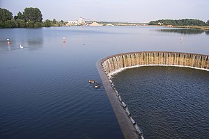
The Lippesee , officially the Sander-Lippe dam , near Sande , a district of Paderborn in North Rhine-Westphalia , is a reservoir of the Lippe tributary Thune in the immediate vicinity of the Lippe.
The weir has a height of 5 m and a length of 66.5 m, the reservoir has a volume of 7 million m³. The lake belongs to the Schlosspark und Lippesee GmbH and was put into operation in 1986. There is a footpath around the Lippesee, this has a length of 7.1 kilometers.
use
The Lippesee is a local recreation area with a wide range of water sports and leisure activities such as sailing, surfing, pedal boating and fishing. There is a small beach at the kiosk on the north bank. There is also a barbecue area, a children's playground, sunbathing lawns, a mountain bike course, a skate park and a mini golf course . Water-skiing opportunities can be found in the adjacent Nesthauser See .
The Lippesee is completely surrounded by mostly paved paths, on which cycling and running sports are possible all year round. With suitable snow conditions, the Lippe Lake circuit is also suitable as a cross-country ski run.
Water sports are possible on the Lippesee. There are two sailing clubs on the lake, the Paderborner Yacht Club eV and the Segler-Verein Paderborn eV, as well as a commercial sailing school.
In addition to its use as a local recreation area, high-quality gravels are also extracted in the lake , which were deposited in layers up to 20 m thick in the last Ice Age at the transition from the Westphalian Bay to the Paderborn plateau, especially in the area of the Lippe Lake. These river deposits come mainly from the Alme and the Beke , which flow into the Lippe above the Lippesees.
Lippe lake flood
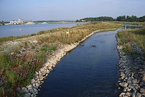
On March 31, 2005, the Lippe lake flood was put into operation. During the five-year construction period, a new river bed was created for the Lippe over a length of 2.6 kilometers in a 60 meter wide substitute floodplain around the southern half of the Lippesees. The goal was to decouple the Lippesees from the Lippe, so that most of the water from the Lippe flows around the lake today. The extensive construction work cost a total of 8.5 million euros.
The reason for the establishment of the flood was the fact that the lake represented a drastic incision and a spread barrier for the Lippe. After its establishment in 1989 , the water quality of the Lippe below the Lippesees deteriorated significantly. This was shown by a higher temperature of the water after it had crossed the lake, and a permanent clouding through enrichment with still water - plankton and suspended matter . Above the lip lake are brown trout , grayling and Koppe , the most common fish species, the area below the lake, however, was mainly from the less demanding eel populated.
Specifically, the Lippstadt State Environment Agency formulated the following planning goals:
- Creation of the continuity of the course of the Lippe for migrating river organisms
- Ensuring sediment transport in the Lippe to restore natural flow dynamics
- Improvement of the water quality in the Lippe below the Lippesees
- Development of near-natural water and floodplain structures
- Reduction of the entry of nutrients and waste into the Lippesee
See also
Individual evidence
- ↑ Wasserverband Obere Lippe: HRB Lippesee (accessed on July 16, 2012)
Web links
- Operating company: Schloßpark und Lippesee GmbH
- Lippesee leisure facilities


