
Gieseler (river)
| Gieseler | ||
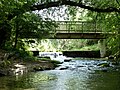
 The Gieseler in Bad Westernkotten |
||
| Data | ||
| Water code | DE : 27852 | |
| location | North Rhine-Westphalia , Germany | |
| River system | Rhine | |
| Drain over | Lippe → Rhine → North Sea | |
| source | Headwaters with Blauer Kolk as the main spring, northwest of the core town of Eikeloh 51 ° 37 ′ 29 ″ N , 8 ° 23 ′ 41 ″ E |
|
| Source height | 97.5 m above sea level NN | |
| muzzle | At Lippstadt - Hellinghausen in the Lippe coordinates: 51 ° 40 ′ 11 ″ N , 8 ° 16 ′ 40 ″ E 51 ° 40 ′ 11 ″ N , 8 ° 16 ′ 40 ″ E |
|
| Mouth height | 72.5 m above sea level NN | |
| Height difference | 25 m | |
| Bottom slope | 1.9 ‰ | |
| length | 12.9 km | |
| Catchment area | 160.57 km² | |
| Discharge at the Bökenförde 2 A Eo gauge : 59 km² at the mouth |
NNQ (1991) MQ Mq HHQ (1995) |
49 l / s 1.11 m³ / s 18.8 l / (s km²) 12.3 m³ / s |
| Left tributaries | Pöppelsche , Mühlenbach, Glasebach | |
The Gieseler is a 12.9 km long left tributary of the Lippe in North Rhine-Westphalia , Germany .
swell
The source area of the Gieseler is located approx. 250 m north of the former Hellweg , today's Bundesstraße 1 , near Eikeloh . Its water arises in the forested headwaters in several individual springs. The most productive of the Giesel springs are the so-called "Blue Kolk" and a spring that is used by the Lippstadt municipal utilities to obtain drinking water. The "Blue Kolk" is almost circular and has a diameter of about 10 m. It owes its name to the blue-green karst water that springs from it. The 4.9 hectare headwaters of the Gieseler have been under nature protection since 1982 due to its geological characteristics and importance as a habitat for wild animal and plant species . After a few hundred meters, the Gieselerwasser is dammed up at the "Hof zur Osten" to generate electricity, before the river on the southwestern edge of Bökenförde picks up the " Pöppelsche ". After 12.9 km the Gieseler joins the Lippe near Lippstadt-Hellinghausen.
Hydraulic structures
Stöckers-Schemm
To the west of Bökenförde lies the Stöckers-Schemm dam. It was built in 1846/47 in order to be able to irrigate the meadows in the Merschfeld with the water from the Gieseler. The water was drained off through flood or drainage ditches of the consecration.
Engelbert-Schemm
In the early 17th century, the city of Lippstadt expanded its fortifications . Sufficient water was needed for the southern flood and around 1678 a connection between the consecration and the Gieseler near Bad Westernkotten was created . A weir in the Gieseler enabled the water to be dammed up at this point, which could then be diverted to Lippstadt through the consecration. Today's weir, also called Engelbert-Schemm, was built in 1852. The right associated with the weir to use 1/3 of the water from the Gieseler to operate the mill in Overhagen and 2/3 to flush canals in Lippstadt still exists today, but is no longer used.
Overhagen weir
The weir on the Gieseler in Overhagen is a relic of medieval manorial rights, with which the water rights of the lords and barons of Schorlemer are connected. This includes regulating the water level in the moats of Overhagen Castle and securing the water levels of the waters leading from Herringhausen into the Lippe . Some of the water dammed up by the weir is led into the branching mill ditch (Mahlbieke) and thus fed to the castle moat. Until 1961, a mill was operated with the water from the mill .
Surname
In the map with the title “Real opportunity of the village Westerenkotten” from the second half of the 16th century, today's Gieseler, in the part between Bökenförde and Bad Westernkotten , is recorded with the name “Die Weyde”. In Eikeloh the Gieseler was called the Beeke in 1614. In Hellinghausen it was called Becke in the 16th century.
Picture gallery

Headwaters of the Gieseler

Stöckers-Schemm near Bökenförde
Engelbert-Schemm near Bad Westernkotten

Weir at Overhagen


Web links
Individual evidence
- ↑ a b c d Topographical Information Management, Cologne District Government, Department GEObasis NRW ( information )
- ↑ a b Dirk Ruholl (ed.): Bökenförde, a village on Gieseler and Pöppelsche. Village history 1005-2005. Bökenförde 2005.
- ↑ Heinz-Josef Sauerland: Sources on Hellweg - Geological-hydrological considerations on the source horizon on Hellweg in the Lippstadt district. Effects on the settlement of this area. C. Jos. Laumanns, Lippstadt 1969.
- ^ Working group for biological environmental protection in the Soest district - protected area SO-014: source area of the Gieseler
- ↑ Dirk Ruholl (ed.): Bökenförde - A village to Gieseler and Pöppelsche. Village history 1005-2005 . Bökenförde 2005. pp. 347-350.
- ↑ Wolfgang Marcus: Consecration, flood, wide ditch. 1990, accessed November 1, 2013 .
- ↑ Heimatbund Lippstadt eV: Eight hundred years Overhagen 1203-2003. Phototypo GmbH, Lippstadt 2003, ISBN 3-9804307-6-6 , p. 51ff.
- ^ Landesarchiv NRW, Westphalia department: Westernkotten (Erwitte): bird's eye view of the town - actual opportunity of the village of Westerenkotten. 2nd half of the 16th century, Duchy of Westphalia, State Archives VIII No. 17.
- ^ Municipality of Bad Westernkotten (ed.): Bad Westernkotten 1258–1958. A home book. C. Jos. Laumanns, Lippstadt 1958.
- ↑ Hubert Schulte Beerbühl: Eikeloh - A village on the Hellweg 836-1986. Self-published, Münster 1985.
- ↑ Baron von Schorlemer's Herringhausen archive: Document No. 172 dated May 8, 1509.
- ↑ Baron von Schorlemer's Herringhausen archive: Document No. 349 of August 18, 1587.


Brockbusch | Gieseler | Güller Bach - Lobbenbach | Limestone quarry south of Erwitte | Limestone quarries southeast of Erwitte | Manninghofer Bach | Muckenbruch | Olle Wiese and Bachsysteme between Erwitte and Stirpe | Headwaters of the Gieseler | Straken quarry southeast of Erwitte | Pöppelsche valley system with Hoinkhauser Bach | Völlinghauser Bach - Sonnenbornbach