
Datteln-Hamm Canal
| Datteln-Hamm Canal | |
|---|---|
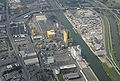
 The canal in Bergkamen, in the background the Bergkamen power station. |
|
| Water code | DE : 70301 |
| abbreviation | DHK |
| location | North Rhine-Westphalia |
| length | 47.145 km |
| Built | Section I to Hamm City Harbor opened to traffic on July 17, 1914, Section II from Hamm to Schmehausen 1926 - August 23, 1933 |
| class | IV , probably from 2017 [obsolete] Part I Vb |
| Beginning | Dortmund-Ems Canal - kilometer 19.51 |
| The End | Feasting |
| Descent structures |
Hamm lock Werries lock |
| Ports | Marina Ribbrock , Waltrop , Stummhafen Brambauer , city harbor Lünen , Preußenhafen , harbor Haus Aden , harbor power station Bergkamen , marina Rünthe , harbor Gersteinwerk , city harbor Hamm , harbor colliery Westphalia , Ruhrmann harbor , harbor Hamm-Schmehausen / power station Westphalia |
| Historical precursors | lip |
| Used river | lip |
| Outstanding structures | Water handover Hamm |
| Kilometrage | uphill |
| Downhill | Direction DEK |
| Responsible WSD | Waterways and Shipping Office Rheine |
The Datteln-Hamm Canal (DHK, water code: 70301) is a federal waterway and branches off from the Dortmund-Ems Canal in Datteln . From here it runs parallel to the Lippe on its south side in an easterly direction through Waltrop , Lünen , Bergkamen to Hamm . Together with the Wesel-Datteln Canal, the canal was also referred to as the Lippe Lateral Canal during the planning and construction phase .
history
The first expansion stage was completed in 1914. It reached behind the Hamm town harbor via the Hamm lock , then in 1926 the canal was expanded through the Werries lock to Schmehausen and put into operation in 1933, where it ends today in a large harbor basin at the Westphalia power plant . Originally, the canal was supposed to be built further to Lippstadt ; However, this project was no longer carried out and was finally abandoned after the Second World War. Abutments for bridges were built in at least three places , two near Vellinghausen and one in the municipality of Lippetal .
Technical specifications
The kilometers of the canal run from dates to mountains. The canal has a total length of 47.145 km and has the two locks Hamm and Werries to compensate for the height difference of 6.75 m.
The channel 42 is crossed by rail, road, road and pedestrian bridges, and conveyor belt 1, and bridge 30 culverts and passages passes under and 38 pipe and Kabeldükern. In the event of an accident, the canal is equipped with two safety gates in Waltrop and Bergkamen, which enable the sections of the canal in front of or behind it to be closed so that the entire canal is not emptied.
expansion
The dimensions of today's inland waterway vessels do not allow oncoming traffic in some sections of the DHK. One-way traffic was therefore introduced in 1997, initially over a length of approx. 18.6 km, now only over 3 km. The western section of the waterway to the railway bridge in Hamm ( Hamm-Osthafen , kilometer 35.87) is to be upgraded to waterway class Vb and allow oncoming traffic by probably 2017 [obsolete] . The eastern section will initially remain in Class IV with the above restrictions.
According to the government agreement between the federal government and the state of North Rhine-Westphalia from 1992, the expanded section will then be navigable between Datteln and Hamm up to and including the Hamm city port for 110 m long large motor cargo ships and 185 m long push convoys. The unloading depth will be 2.80 m; the maximum permissible ship width is then 11.45 m. In addition, construction measures were and are necessary to remove subsidence caused by mining.
Function in the dewatering of the West German sewer network
In addition to its original main purpose of shipping, the canal also serves to feed water from the Lippe into the West German canal network . The Lippe in Hamm is dammed for this purpose. In the water distribution system between the weir and the lock, the amount of water to be fed into the DHK can be controlled by damper weirs (up to 25 m³ / s). The water from the Lippe flows through the feed structure above the weir, which was expanded by a second one in 1965, from the dammed Lippe into the Hamm canal and next to the lock through the free tide down the DHK in a natural gradient. This supplies the Datteln-Hamm, Dortmund-Ems , Rhein-Herne and Wesel-Datteln canals with process water.
If the water flow from the Lippe is low (below 10 m³ / s), the feed structure is closed. The water supply of the West German canals and the securing of a minimum water flow in the Lippe through the transfer structure from the DHK to the Lippe below the Hamm lock then takes place solely through the pumping stations at the other canal levels. The Water Association of West German Canals (WWK) is responsible for balancing the water flow.
Ports


The largest port and most important transshipment point is the city port of Hamm , Germany's second largest public canal port, with 1.75 million tonnes of waterside transhipment and 0.65 million tonnes of rail throughput in the 2008 financial year. The city port of Lünen is the second largest port on the Datteln-Hamm Canal with 0.9 million tons of handling. In addition, there are a number of power plant ports ( Bergkamen power plant , Gerstein plant and Westphalia power plant ), colliery ports ( Preußenhafen , Zeche Haus Aden , colliery Westphalia and Bergwerk Ost ), the silent port Brambauer , port Waltrop and the Ruhrmann port in Uentrop , whose turnover is lower, as well some marinas.
The most important cargo handled by the ports on the DHK are hard coal, cement, sand, gravel, gas, oil and petrol. The transport volume is around 7 million t per year, the city port of Hamm regularly handles around a quarter of the total volume of goods.
administration
In 1978 the water and shipping office (WSA) Hamm was dissolved and continued as a branch of the water and shipping office in Rheine. The branch is on Adenauerallee, directly on the canal. The outer district (ABz) Hamm is also located on Fährstraße, also directly on the canal.
Recreational use
In the meantime, the importance of sport boat tourism and the recreational use of the DHK has increased. Along the Datteln-Hamm Canal, as on the other canals in the Ruhr area , there are a number of harbors, stops and resting places for hikers, one of the largest is the Rünthe Marina . There are also numerous anglers who spend their free time on the Datteln-Hamm Canal. In summer, many use the canal for swimming.

Marina Rünthe near Bergkamen
Aerial view of the Hamm city harbor
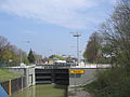
Werries lock in Hamm
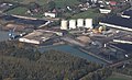
Almost the end of the canal at Uentrop harbor


The waterway plays a religious role for the Hindus of the nearby Sri Kamadchi Ampal Temple in Hamm.
literature
- M. Eckoldt (Hrsg.): Rivers and canals, The history of the German waterways . DSV, 1998.
Individual evidence
- ↑ Directory E, serial no. 5 der Chronik ( Memento of the original from July 22, 2016 in the Internet Archive ) Info: The archive link was inserted automatically and has not yet been checked. Please check the original and archive link according to the instructions and then remove this notice. , Federal Waterways and Shipping Administration.
- ↑ 51 ° 40 '16.8 "N; 7 ° 59 ′ 04.1 "E and 51 ° 40 ′ 01.5" N; 8 ° 00 ′ 01.1 ″ E
- ↑ 51 ° 39 '20.8 "N; 8 ° 02 ′ 06.5 ″ E.
- ↑ Lengths (in km) of the main shipping lanes (main routes and certain secondary routes) of the federal inland waterways ( memento of the original from January 21, 2016 in the Internet Archive ) Info: The archive link was inserted automatically and has not yet been checked. Please check the original and archive link according to the instructions and then remove this notice. , Federal Waterways and Shipping Administration.
See also
Web links
- General Directorate for Waterways and Shipping - West Branch, DHK
- Water and Shipping Office Rheine
- Waterway class DHK and German waterways with expansion planning in alphabetical order ( Memento from February 21, 2007 in the Internet Archive ) (PDF file; 126 kB)
- Sport boat area in the Ruhr area
- Information on the Datteln-Hamm Canal on SkipperGuide
- Information on the occasion of the 100th anniversary of the canal
Coordinates: 51 ° 37 ′ 51.4 " N , 7 ° 36 ′ 30.8" E