Hamm city harbor
| Hamm city harbor | |||
|---|---|---|---|
| Data | |||
| UN / LOCODE | DE HMM | ||
| opening | 1914 | ||
| Port type | Lands | ||
| website | http://www.stadtwerke-hamm.de/hafen/ | ||
| Geographic information | |||
| place | Hamm | ||
| country | North Rhine-Westphalia | ||
| Country | Germany | ||
| Port area Hamm 2007 | |||
| Coordinates | 51 ° 40 ′ 44 " N , 7 ° 46 ′ 58" E | ||
|
|||
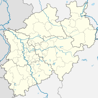
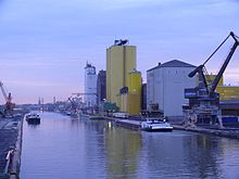
The city port of Hamm is a trimodal logistics center and is located on the Datteln-Hamm Canal in the North Rhine-Westphalian city of Hamm . It is the second largest public canal port in the Federal Republic of Germany . The operator is Hafen Hamm GmbH, a subsidiary of Stadtwerke Hamm GmbH . The catchment area of the port extends far beyond Hamm into the Münsterland , Sauerland and southern East Westphalia as well as Hesse and connects these regions with the European waterway network and the North and Baltic Sea ports of Germany and the Netherlands .
The city port of Hamm is part of the Route of Industrial Culture, theme route 7 ( Industrial Culture on the Lippe ).
Technical specifications
The port facility was created as a parallel port to the Lippe , the quay length of which is given as 3.4 km. Today it has an area of around 6 km 2 (600 ha), of which 0.57 km 2 (57 ha) are in the water in the port area. The port can currently be called by motorized goods ships with a total length of 110 meters and a width of 11.45 meters with a discharge depth of 2.7 meters. Push convoys are permitted up to a length of 165 meters. The port area is also accessed by a port railway with a track length of 12 km and three diesel locomotives .
Cargo handling and storage capacities
In 2007, 1723 ships were handled in the city harbor. In 2008, around 1,750,000 t of shipping goods were unloaded or bunkered and 750,000 t of rail goods were handled. The annual report of Stadtwerke Hamm indicates the increase over the previous year at -4%. In 2013 only 1.5 million tons were handled. In Hamm, a fifth to a quarter of the total amount of goods transported on the Datteln-Hamm Canal is regularly loaded.
The main goods handled are grain, food and feed, as well as the energy sources coal and mineral oil, as well as large quantities of steel, as well as metal and iron waste, some of which are raw materials for the steel processing industry. Other main cargo handled are building materials, stones, earth and ores, as well as fertilizers and products from the chemical industry.
| Storage capacity | |
|---|---|
| Mineral oils and petrol | 108,500 m 3 |
| Oilseeds | 63,000 t |
| Cooking oil | 12,700 m 3 |
| glue | 4,530 m 3 |
| Gravel and sand | 2,900 t |
| Warehouses | 40,000 m 3 |
In addition to the city port, there are other ports in the city area of Hamm; together with the city port, they handled 3.1 million tonnes of ships in 2007.
history
Before the canal construction
The river navigation had commercially in Europe for thousands of years is particularly important. The Celts already used the rivers to transport raw materials and goods. This also applies to the time of the Roman Empire for the Lippe. Archaeological finds in neighboring Bergkamen indicate a corresponding landing site at the Roman camp there. These remains are at the same time the oldest surviving references to the regular use of the Lippe as a waterway, comparable to today's shipping. The later Hanseatic city of Hamm, which was founded in 1226 at the confluence of the Ahse and the Lippe, used the river in a variety of ways from the start. However, it was not until the beginning of the 19th century that a modern port was built in Hamm and the river expanded for the first time, so that in 1826 the first ship passed through the lock at Hamm. The event was greeted with a cannon salute. The now increasing shipping traffic suffered a severe slump after the railroad reached Hamm in 1846. Attempts with steam shipping had been abandoned by the "Rhein- und Lippe Schleppschiffahrts-Gesellschaft", founded in 1854, due to a lack of profitability. In addition to the strong competition from the Cöln-Mindener Eisenbahn, the cause was the constant change in the Lippe, which influenced navigability and finally brought shipping traffic to a complete standstill from 1870 onwards. As early as the 1890s, the city bought 172 acres of land on both sides of the Lippe in order to build a new port facility for shipping on the Lippe River. Shipping in Hamm was not started on July 17, 1914 via the Lippe, but via the new canal that connected Hamm with the Dortmund-Ems Canal .
Datteln-Hamm Canal
With the completion of the Datteln-Hamm Canal, the parallel port in Hamm was laid out on the south bank and put into operation. From this time on, the city could be approached with 600 t ships. In the first year of operation, the port handled around 31,000 t. 24 years later it was already around 745,000 t. In 1926 the canal was extended from Hamm to Uentrop and Schmehausen, where it ends today in the Kanalendhafen in Schmehausen . The originally planned extension to Lippstadt was never realized.
The bombs from the Second World War , which also hit the industrial location Hamm in particular and destroyed 60% of the city, caused another interruption of shipping in Hamm. The canal could only be opened to traffic again in 1946 after repairs. However, the port's economic development was only briefly interrupted, and in 1951 the port reached the pre-war handling figures. The rapid economic growth of the post-war period also led to the expansion of the port: in 1960 the north port, in 1971 the oil port and finally in 1993/94 the expansion of the west port.
The companies that are located in the area of the port induce around 2,000 jobs in the middle center of Hamm today .
expansion
With the expansion of the Datteln-Hamm Canal and the port to European standards, it will in future be possible for ships up to 135 m in length and push convoys up to a total length of 186.5 m to reach the port of Hamm. As part of the expansion, the canal will be widened by 5 m to the north, new berths will be created and the northern quay wall will be replaced with sheet piling. In addition, the reversible pool is enlarged. The port itself is endeavoring to move more volumes through the establishment of new feed and fertilizer mixing plants.
Other ports in Hamm
In addition to the ports of RWE Power AG at the Gersteinwerk power plant and the Westfalen power plant, the transshipment port of the Rheinisch-Westfälische Baustoff und Speditionsgesellschaft Ruhrmann GmbH & Co in Hamm-Uentrop is also located in the urban area . The Uentrop coal transshipment port of the closed Westphalia colliery and the old transshipment of the Franz mine of the Ost Bergwerkes , which was closed in 2010, are no longer in operation .
Individual evidence
- ↑ http://www.destatis.de/jetspeed/portal/cms/Sites/destatis/Internet/DE/Content/Publikationen/Querschnittsveroeffnahmungen/WirtschaftStatistik/Verkehr/Binnenschifffahrt2007,property=file.pdf Hafen Hamm in the statistics of Destatis 2007 also includes the private ports in Hamm
- ↑ http://www.bonapart.de/nachrichten/beitrag/hafen-hamm-agrar-mischwerke-sollen-mehr-schiffsladungen-haben.html Port of Hamm: Agricultural mixing plants should bring more shiploads, Bonapart - inland shipping up to date
Web links
- Description of this sight on the route of industrial culture
- Stadtwerke Hamm Hafen
- Economic development Hamm industrial area Hafen
- Statistical yearbook 2010 of the city of Hamm, port envelope page 124 (PDF file; 1.34 MB)


