
Haltern waterworks
The Haltern waterworks is located in Haltern am See in the northern Ruhr area . The waterworks, which went into operation in 1908, supplies around 1 million people, as well as industry and commerce in the northern Ruhr area, western Münsterland and Duisburg with drinking water .

The capacity is around 125 million m³ per year, that is around 350,000 m³ per day. The operator is Gelsenwasser AG , which also operates its information center for water extraction , which was opened in 1996 .
The waterworks is part of the route of industrial culture, themed route industrial culture on the Lippe and can be visited by appointment.
location
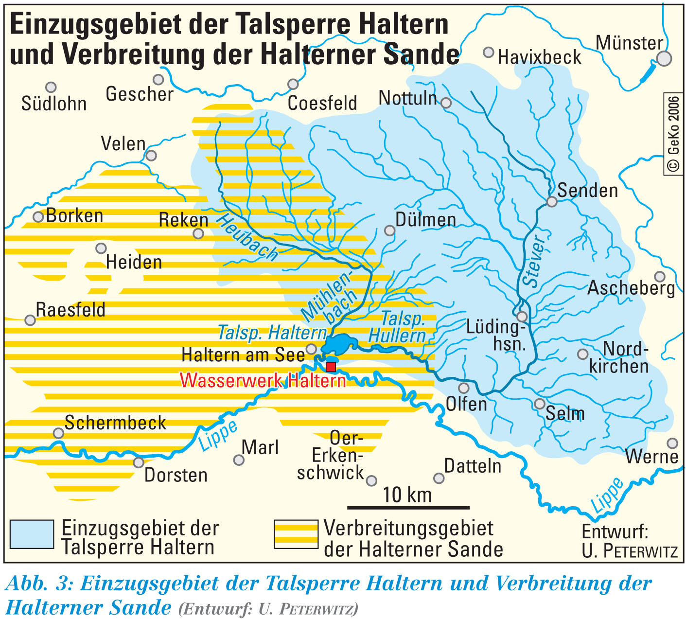
The waterworks is located in Haltern am See between the Lippe and the Haltern reservoir on the water extraction site (protection zone 1, approx. 200 hectares including the southern basin: 56 hectares). It can be clearly seen in aerial photographs by means of its 26 infiltration basins (total filter area: 335,000 m²). In addition, there are well systems on the waterworks site (around 200 vertical wells with depths of 40 m to 70 m and a total output of up to 518,000 m³ / day) and in the forest areas of the Haard (21 vertical wells, depth up to 93 m, maximum 23,000 m³ / day) and the Hohe Mark (10 vertical wells, depth up to 165 m, maximum 15,000 m³ / day). Pump stations on the Halterner and Hullerner See ensure that water can be withdrawn from the reservoirs and directed into the infiltration basins at any time, even when the level is low.
Water extraction
About 30% of the drinking water is obtained from groundwater naturally formed by precipitation (wells in the Haard and Hohe Mark) and about 70% through groundwater recharge . In times of low rainfall, up to 200,000 m³ of water can be taken from the Dortmund-Ems Canal every day and discharged into the Stever at Senden , so that water is still available in the dam system by means of the pumping stations.
The water collection and treatment in individual steps:
- The water first goes through a pre-treatment in the southern basin of the Haltern reservoir. If necessary, flocculants and activated carbon are added . The resulting flakes largely bind the dissolved and undissolved ingredients (including pesticides), reduce the phosphate content and thus eutrophication . They are removed by sedimentation .
- The raw water is then taken from the south basin by pumping stations (20,000 m³ / hour total delivery rate) and fed via 4500 m long concrete pipes to the 26 differently sized infiltration basins (4,000 m² to 21,000 m², total area: 335,000 m²).
- The naturally existing sands act as slow sand filters , the water remains underground for about 6 weeks.
- The purified groundwater is extracted through the vertical wells on the waterworks site.
- Part of the well water obtained is passed through pressure filter tanks filled with quartz gravel for biological demanganization .
- In the deep tanks on the waterworks site (a total of 28,000 m³ content), all the water obtained is brought together.
- There are still sodium hydroxide solution (pH adjustment) and monophosphate (anticorrosive) was added. There is also the option of disinfection using sodium hypochlorite .
- Finally, the drinking water is fed into the supply network by means of electric pumps. In the event of a power failure, diesel generators take over the local power supply.
Halterner Sande
Artificial groundwater recharge is a near-natural process that was established in Haltern due to the special geological situation.
- The Halterner Stausee and Hullener See dams collect an average of 240 million m³ of water annually from the 880 km² catchment area of the Stever and the Haltern Mühlenbach .
- This surface water is discharged into the Haltern Sande via infiltration basins .
These up to 300 m thick layers of sand lead to around 100 m of their total thickness and offer special hydrogeological conditions for filtering the slowly flowing water (flow speed around 0.5 to 1.5 m per day). They have an area of around 770 km² and reach in the south from Dorsten, Marl, Oer-Erkenschwick to Seppenrade. In the northeast they touch the cities of Dülmen and Coesfeld. In the northwest they extend to the cities of Gescher and Borken and in the west to the communities of Raesfeld and Schermbeck. The layers consist for the most part of loose, silty sands, in the deeper areas they are also solidified and interspersed with gravel , sand-lime stone and quartzite banks. They are underlain by the Recklinghausen sand marls.
The Haltern Sands have a high hopefulness, i.e. a high ability to store and transport water. The wells in the sands achieve a high productivity. The theoretically usable volume of groundwater is 17 km³ (17 billion cubic meters).
The groundwater taken from the Haltern Sands is mineralized and is therefore particularly suitable for the production of drinking water.
Influences on water quality
The Haltern waterworks is located in the coal mining area on the northern edge of the Ruhr area. In order to avoid damage from subsidence and the influx of heavily mineralized water from the Lippe, an agreement was signed between the mining industry and the local water supplier. Among other things, mining limits to the south of the waterworks have been laid down and regular geodetic measurement programs for monitoring have been agreed.
The catchment area of the reservoirs is used intensively for agriculture . The used therein pesticides were detected in the 80's in elevated concentrations in the tributaries and the reservoirs themselves. The atrazine contamination caused by maize cultivation became particularly well known . To maintain the water quality, immediate measures (activated charcoal dosage in the pre-cleaning) and longer-term measures (cooperation with agriculture) were introduced. The cooperation with agriculture showed clear successes, so that the activated charcoal dosage could be reduced significantly and temporarily stopped completely.
The AWHS (Arbeitsgemeinschaft Wasserwerke Halterner Sande) was founded in June 1998 by the municipal utilities Borken, Coesfeld, Dülmen, Gescher, the Rheinisch-Westfälische Wasserwerkgesellschaft mbH (RWW) and the Gelsenwasser AG to improve cooperation with each other, with the state water authorities and agriculture .
There are officially established water protection areas around the reservoirs and for the extraction systems in the Haard and in the Hohen Mark. Since the reservoir water is not directly treated technically, but is first drained away, the reservoirs are available to the public for limited leisure activities. Water sports ( Haltern seaside resort , sailing, excursion boat "Möwe", boat rental, etc.) may be practiced on the Haltern Reservoir and partly on the Zwischenstever, but this is not permitted on the Hullern Reservoir (nature conservation is in the foreground). Both lakes and the diverse landscape around them are accessible via a network of hiking and cycling trails.
Nitro compounds and other carcinogens from the production and dumping of the former WASAG in Sythen are expected by around 2050. The Recklinghausen district is responsible for containing this danger.
Coverage area
The following are supplied directly via Gelsenwasser AG or indirectly via reseller partners: Altenberge , Billerbeck (partly), Castrop-Rauxel (partly), Datteln , Dülmen (partly), Duisburg (partly), Gelsenkirchen (urban area except Feldmark, Neustadt, Rotthausen, Ückendorf, Bulmke-Hüllen), Haltern am See , Havixbeck , Herne (partly), Herten , Lüdinghausen , Marl , Münster (partly), Nordkirchen (partly), Nordwalde (partly), Nottuln (partly), Oer-Erkenschwick , Olfen , Recklinghausen , Selm (partially), Senden (core city, Bösensell) and Waltrop .
Others
The highest daily volume was delivered on July 2, 1986 with 413,868 m³.
Around 100 employees and up to 25 trainees are employed at the Haltern waterworks.
On August 17, 2008, the 100th anniversary of the waterworks was celebrated with an open day.
Individual evidence
- ↑ Google Map satellite image
- ↑ Taken from the information boards in the Halterner Wasserwerk information center
- ↑ AWHS “Halterner Sande” short version ( Memento from August 13, 2012 in the Internet Archive ) (PDF; 3.1 MB)
- ↑ What are the Haltern Sands? ( Memento from August 10, 2012 in the Internet Archive )
- ↑ http://www.lanuv.nrw.de/veroeffnahmungen/ggb97/gb97k5t2.htm (link not available)
- ↑ Cooperations. In: gelsenwasser.de. October 17, 2018, accessed November 30, 2018 .
- ^ Publication of the Chamber of Agriculture "Cooperation between Agriculture and Water Management in the Stevertalsperre catchment area", 2007
- ↑ Maps of the water protection areas ( Memento from August 10, 2012 in the Internet Archive )
- ↑ https://www1.wdr.de/nachrichten/westfalen-lippe/wasag-altlasten-sprengstoff-haltern-100.html
- ↑ https://www.kreis-re.de/Inhalte/Buergerservice/Umwelt_und_Tiere/Umwelt/Untere_Bodenschutzbehoerde/_Grundwassernutzungsverbot_Haltern_Sythen-Lehmbraken.asp
- ↑ Information from Gelsenwasser AG about the Haltern waterworks
Web links
- Haltern waterworks brochure (393 kB)
- LWL: catchment area of the Haltern dam and distribution of the Haltern Sands
- Website of the Arbeitsgemeinschaft der Halterner Sands
- Description of all locations on this themed route as part of the Route of Industrial Culture
Visitor center and anchor points (from west to east): Museum of German Inland Shipping | Inner harbor Duisburg | LVR Industrial Museum Oberhausen | Landscape Park Duisburg-Nord | Gasometer Oberhausen | Aquarius Water Museum | St. Antony Hut | Villa Huegel | Nordsternpark | Zeche Zollverein World Heritage Site and Zollverein Coking Plant | Ewald colliery | Marl Chemical Park | Railway Museum Bochum-Dahlhausen | Henrichshütte | Centennial Hall Bochum | Recklinghausen substation | German Mining Museum | Nightingale colliery | Henrichenburg ship lift | DASA | Hansa coking plant | Zeche Zollern II / IV | Hohenhof | Hagen Open Air Museum | Lindenbrauerei Unna | Maximilian Park Hamm
Themed routes (in ascending order by number): 1. Duisburg: City and Harbor | 2. Industrial cultural landscape Zollverein | 3. Duisburg: industrial culture on the Rhine | 4. Oberhausen: Industry makes the city | 5. Krupp and the city of Essen | 6. Dortmund: triad coal, steel and beer | 7. Industrial culture on the Lippe | 8. Erzbahn-Emscherbruch | 9. Industrial culture at Volme and Ennepe | 10. Brine, steam and coal | 11. Early industrialization | 12. The past and present of the Ruhr | 13. On the way to the blue Emscher | 14. Canals and shipping | 15. Lanes in the area | 16. Westphalian mining route | 17. Rhenish mining route | 18. Chemistry, Glass and Energy | 19. Workers' settlements | 20. Entrepreneur villas | 21. Bread, grain and beer | 22. Myth of the Ruhr Area | 23. Parks and Gardens | 24. Industrial nature | 25. Panoramas and Landmarks | 26. Sacred buildings | 27. Iron & Steel | 28. Water: works, towers and turbines | 29. Bochum - industrial culture in the heart of the district | 30. Gelsenkirchen | 31. Industrial Culture and Bauhaus Route | by bike

Maximilianpark ![]() |
Way to school footbridge |
Werries lock |
Lippe lock Heessen |
Kurpark Hamm |
Water handover Hamm |
Hamm lock |
Klostermühle Pohl |
Water towers on Hellweg |
Hamm train station |
Hamm city harbor |
Zeche Sachsen today Öko-Zentrum NRW |
Vogelsang settlement |
Radbod colliery |
Radbod Colliery Memorial |
Gersteinwerk |
East mine , Heinrich Robert shafts |
Kissinger Höhe
|
Way to school footbridge |
Werries lock |
Lippe lock Heessen |
Kurpark Hamm |
Water handover Hamm |
Hamm lock |
Klostermühle Pohl |
Water towers on Hellweg |
Hamm train station |
Hamm city harbor |
Zeche Sachsen today Öko-Zentrum NRW |
Vogelsang settlement |
Radbod colliery |
Radbod Colliery Memorial |
Gersteinwerk |
East mine , Heinrich Robert shafts |
Kissinger Höhe ![]() |
Ost colliery , shaft Lerche |
Rünthe express train settlement |
Schacht III cultural center |
Marina Rünthe |
Werne colliery | Old office building today Karl-Pollender-Stadtmuseum Werne |
Monopol mine, Grimberg shaft 1/2 |
Heap of large wood
|
Ost colliery , shaft Lerche |
Rünthe express train settlement |
Schacht III cultural center |
Marina Rünthe |
Werne colliery | Old office building today Karl-Pollender-Stadtmuseum Werne |
Monopol mine, Grimberg shaft 1/2 |
Heap of large wood ![]() |
Colliery House Aden |
Seepark Lünen |
"Westfalia" canteen |
Prussia port |
Ziethenstrasse settlement
|
Colliery House Aden |
Seepark Lünen |
"Westfalia" canteen |
Prussia port |
Ziethenstrasse settlement ![]() |
"Am Kanal" settlement |
Victoria Settlement |
Brickwork Siegeroth |
Cappenberg Castle |
Lünen power plant |
Zeche Minister Achenbach , shaft 4 with the LÜNTEC tower |
Miners Residential Museum |
Waltrop colliery |
Waltrop Local History Museum in the Riphaushof |
Old Henrichenburg ship lift
|
"Am Kanal" settlement |
Victoria Settlement |
Brickwork Siegeroth |
Cappenberg Castle |
Lünen power plant |
Zeche Minister Achenbach , shaft 4 with the LÜNTEC tower |
Miners Residential Museum |
Waltrop colliery |
Waltrop Local History Museum in the Riphaushof |
Old Henrichenburg ship lift ![]() in the Waltrop lock park |
Beisenkamp settlement |
Hermann Grochtmann Museum |
Canal cross dates |
Remote control center for water supply Datteln |
Datteln-Natrop lock group |
Canal bridge Alte Fahrt |
"Leaning Bridge" in Olfen |
Canal bridge over the Stever | Former Lippe lock Vogelsang |
Waterworks Haltern of Gelsenwasser AG |
Quartz sand and grinder Haltern-Sythen |
Auguste Victoria Mine Shaft 8 |
Auguste Victoria mine shaft 1/2 |
Auguste Victoria mine shaft 3/7 |
Marl Chemical Park
in the Waltrop lock park |
Beisenkamp settlement |
Hermann Grochtmann Museum |
Canal cross dates |
Remote control center for water supply Datteln |
Datteln-Natrop lock group |
Canal bridge Alte Fahrt |
"Leaning Bridge" in Olfen |
Canal bridge over the Stever | Former Lippe lock Vogelsang |
Waterworks Haltern of Gelsenwasser AG |
Quartz sand and grinder Haltern-Sythen |
Auguste Victoria Mine Shaft 8 |
Auguste Victoria mine shaft 1/2 |
Auguste Victoria mine shaft 3/7 |
Marl Chemical Park ![]() |
Ready settlement ( Marl ) of the chemical works Hüls |
Brassert settlement |
Auguste Victoria colliery , shaft 4/5 |
Loemühle Airport |
Ruhrgas Dorsten |
Prince Leopold Mine |
Fürst Leopold settlement |
Dorsten lock group |
Dorsten station |
Gahlenscher Kohlenweg |
Dorsten-Holsterhausen waterworks |
Tüshaus-Mühle |
Menting earth building |
Roof tile works Nelskamp | Lippe-Treidlerdorf Krudenburg |
Black Heath Airfield |
Friedrichsfeld lock group | Former Lippe Harbor Wesel |
Old waterworks Wesel |
Water tower Wesel |
Rhine bridge Wesel |
Municipal Rhine port of Wesel |
Prussia Museum Wesel
|
Ready settlement ( Marl ) of the chemical works Hüls |
Brassert settlement |
Auguste Victoria colliery , shaft 4/5 |
Loemühle Airport |
Ruhrgas Dorsten |
Prince Leopold Mine |
Fürst Leopold settlement |
Dorsten lock group |
Dorsten station |
Gahlenscher Kohlenweg |
Dorsten-Holsterhausen waterworks |
Tüshaus-Mühle |
Menting earth building |
Roof tile works Nelskamp | Lippe-Treidlerdorf Krudenburg |
Black Heath Airfield |
Friedrichsfeld lock group | Former Lippe Harbor Wesel |
Old waterworks Wesel |
Water tower Wesel |
Rhine bridge Wesel |
Municipal Rhine port of Wesel |
Prussia Museum Wesel

Old waterworks Wesel |
Bockum waterworks |
Duisburg-Mündelheim waterworks |
Mülheim Styrum / Ost waterworks |
Mülheim-Dohne waterworks |
Essen-Kettwig waterworks |
Wolfsbachtal Essen Waterworks |
Bochum-Stiepel waterworks |
Verbund waterworks Witten |
Dorsten-Holsterhausen waterworks |
Haltern Waterworks |
Rohrmeisterei Schwerte |
Vinner water tower |
Water tower Wesel |
Rheinhausen-Bergheim water tower |
Water tower of the Lower Rhine gas and water works |
Aquarius Water Museum ![]() |
RWW Headquarters |
Mülheim-Fulerum water tower |
Water tower Essen-Condition |
Water tower Steeler Berg |
Essen-Steele water tower |
Essen-Byfang water tower |
Essen-Bredeney water tower |
Water tower Frillendorfer Höhe |
Water room Bochum-Stiepel |
Water tower Bochum-Weitmar |
Herten double water towers |
Water towers on Hellweg |
Water tower Lanstroper egg |
Bommerholz water tower |
Volmarstein-Loh water tower |
Hagen-Hohenlimburg water tower |
Blue water tower Ahlen | Water tower of the Pattberg colliery | Double cooling plant in the Duisburg-Nord landscape park
|
RWW Headquarters |
Mülheim-Fulerum water tower |
Water tower Essen-Condition |
Water tower Steeler Berg |
Essen-Steele water tower |
Essen-Byfang water tower |
Essen-Bredeney water tower |
Water tower Frillendorfer Höhe |
Water room Bochum-Stiepel |
Water tower Bochum-Weitmar |
Herten double water towers |
Water towers on Hellweg |
Water tower Lanstroper egg |
Bommerholz water tower |
Volmarstein-Loh water tower |
Hagen-Hohenlimburg water tower |
Blue water tower Ahlen | Water tower of the Pattberg colliery | Double cooling plant in the Duisburg-Nord landscape park ![]() | Cooling towers of the Zeche Zollverein XII
| Cooling towers of the Zeche Zollverein XII ![]() |
RWW water tower |
Kaiser Wilhelm Tower | Water storage at the Jahrhunderthalle Bochum
|
RWW water tower |
Kaiser Wilhelm Tower | Water storage at the Jahrhunderthalle Bochum ![]() |
Water tower from Luhn & Pulvermacher / Dittmann & Neuhaus | Elevated water tank of the Henrichshütte
|
Water tower from Luhn & Pulvermacher / Dittmann & Neuhaus | Elevated water tank of the Henrichshütte ![]() | Cooling towers of the Hansa coking plant
| Cooling towers of the Hansa coking plant ![]() |
Rheinhausen-Friemersheim water tower | Water towers Railway depot and marshalling yard Duisburg-Wedau |
Hochfeld water tower | Water tower at Oberhausen main station |
Roundhouse and Camera Obscura | Water tower in the Bochum Railway Museum |
Water tower Dortmund Südbahnhof | Water tower at Dortmund depot |
Heilenbeck dam |
Ennepetalsperre |
Glörtalsperre |
Hasper dam |
Kahlenberg return pumping station |
Emscher estuary sewage treatment plant |
Alte Emscher pumping station |
Schwelgern pumping station |
Schmidthorst pumping station |
Emscher sewage park |
Läppkes Mühlenbach |
BernePark |
Bottrop sewage treatment plant |
Gelsenkirchen-Horst pumping station |
Emscherbruch |
Nettebach pumping station |
Dortmund-Deusen sewage treatment plant |
Emscherpumpwerk Huckarde |
Evinger Bach pumping station |
Emscher Bridge Lindberghstrasse |
Kaßlerfeld sewage treatment plant |
Historic sewage treatment plant Essen-Rellinghausen |
Run-of-river power plant Kahlenberg |
Raffelberg hydropower plant |
Baldeney hydropower plant |
Hohenstein hydropower plant |
Harkort power plant |
Pumped storage power plant Koepchenwerk |
Schwitten run-of-river power plant |
Wickede run-of-river power plant |
Friedrichsbad Schwelm |
Kurpark Königsborn |
Kurpark Hamm |
Raffelberg saltwater pool |
Museum of German Inland Shipping
|
Rheinhausen-Friemersheim water tower | Water towers Railway depot and marshalling yard Duisburg-Wedau |
Hochfeld water tower | Water tower at Oberhausen main station |
Roundhouse and Camera Obscura | Water tower in the Bochum Railway Museum |
Water tower Dortmund Südbahnhof | Water tower at Dortmund depot |
Heilenbeck dam |
Ennepetalsperre |
Glörtalsperre |
Hasper dam |
Kahlenberg return pumping station |
Emscher estuary sewage treatment plant |
Alte Emscher pumping station |
Schwelgern pumping station |
Schmidthorst pumping station |
Emscher sewage park |
Läppkes Mühlenbach |
BernePark |
Bottrop sewage treatment plant |
Gelsenkirchen-Horst pumping station |
Emscherbruch |
Nettebach pumping station |
Dortmund-Deusen sewage treatment plant |
Emscherpumpwerk Huckarde |
Evinger Bach pumping station |
Emscher Bridge Lindberghstrasse |
Kaßlerfeld sewage treatment plant |
Historic sewage treatment plant Essen-Rellinghausen |
Run-of-river power plant Kahlenberg |
Raffelberg hydropower plant |
Baldeney hydropower plant |
Hohenstein hydropower plant |
Harkort power plant |
Pumped storage power plant Koepchenwerk |
Schwitten run-of-river power plant |
Wickede run-of-river power plant |
Friedrichsbad Schwelm |
Kurpark Königsborn |
Kurpark Hamm |
Raffelberg saltwater pool |
Museum of German Inland Shipping ![]() |
Ebertbad |
Friedrichsbad Essen |
Leisure center Haus Wittringen |
Parkbad South |
Volkspark outdoor pool |
Ruhrnatur House
|
Ebertbad |
Friedrichsbad Essen |
Leisure center Haus Wittringen |
Parkbad South |
Volkspark outdoor pool |
Ruhrnatur House
Coordinates: 51 ° 44 ′ 8 ″ N , 7 ° 12 ′ 19 ″ E