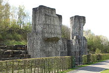
North Star Park
The Nordsternpark is a landscape park on the site of the former Nordstern colliery in Gelsenkirchen .
After the Nordstern colliery was closed in 1993, the premises were completely renovated and turned into a landscape park. In 1997 the Federal Garden Show took place in the park . The Nordsternpark, which connects the Gelsenkirchen districts of Horst and Heßler , is divided by the Rhine-Herne Canal and the Emscher .
The park is part of the European Garden Heritage Network and the Route of Industrial Heritage .
Family and free time
After the National Garden Show in 1997, the spacious (water) playground at the level of the Rhine-Herne Canal was continued in the Nordsternpark . This is a popular destination for families and school classes, especially on warm days. Adventure rallies for children are also offered in the Kinderland. The Hessler / Nordsternpark landscape park also offers many footpaths and bike paths all year round, as well as Segway rental. The adventure-based Ziegenmichelhof is also a popular destination in the park.
There is a multi-storey car park and several parking spaces, restaurants, barbecue areas and a hotel, park festivals and marathon events.
Amphitheater Gelsenkirchen
The Gelsenkirchen amphitheater is also located on the grounds of the Nordsternpark. Many events take place in the amphitheater, mainly in spring and summer. Regular events include the Night of Industrial Culture - ExtraSchicht , the Rock Hard Festival , the Canal Festival, the open-air cinema, the Blackfield Festival, as well as concerts by various regional, national and international artists and bands.
The special features of the Nordsternpark
The Nordsternpark shows as part of the route of industrial culture :
- the integration of former colliery buildings into the landscape park,
- an open-air stage (Amphitheater Gelsenkirchen) on the Rhine-Herne Canal,
- a jetty on the Rhine-Herne Canal with scheduled trips in summer by the White Fleet Baldeney ,
- three 18-meter-high artificial climbing rocks,
- a 63-meter-long mining tunnel that was created by apprentices in 1997 and can be visited
- from 1999 to the end of 2016 the Deutschlandexpress , most recently the third largest Märklin railway in the world
- several technical and creative suspension bridges over the Rhine-Herne Canal and the Emscher
- the Hercules of Gelsenkirchen , an 18-meter-high and 23-ton sculpture by the German artist Markus Lüpertz
- Various former buildings and new buildings are now used as a business park, including by the mining-affiliated company Vivawest
Double arch bridge

In 1996, a 36 m high double arch bridge made of steel was built for the Federal Horticultural Show . With a span of 80 m and two asymmetrical but parallel arches, it lies diagonally above the Rhine-Herne Canal and can be passed on foot or by bike. The construction is a design by Stefan Polónyi .
Further expansion
As part of the 2010 Capital of Culture year , the Nordsternpark was one of the seven “anchor points”. By autumn 2010, the tower of shaft II of the Nordstern colliery was expanded with a glass cube and a "Hercules" statue; these together raise the tower to 103 meters. The Nordsternpark is to become part of the International Horticultural Exhibition in 2027 .
Individual evidence
- ↑ Homepage of the Gelsenkirchen Alpine Club
- ↑ Ursula Kleefisch-Jobst (Ed.): Stefan Polónyi. Load-bearing lines - load-bearing surfaces . Catalog. Ed. Menges, Fellbach 2012, ISBN 978-3-936681-58-1 .
- ↑ Information sheet of the Ruhr.2010 on the project ( Memento from February 2, 2014 in the Internet Archive ) (PDF; 1.5 MB)
Web links
- Description of this attraction and anchor point as part of the Route of Industrial Heritage
- City of Gelsenkirchen - Nordsternpark
- Nordsternpark GmbH
- Homepage of the amphitheater
Coordinates: 51 ° 31 ′ 25 ″ N , 7 ° 2 ′ 0 ″ E


