
Dreieck-Siedlung Hochlarmark


The triangle settlement Hochlarmark is a colliery settlement in Recklinghausen in the district of the same name. The settlement got its name from the unusual arrangement of its streets.
history
After the Recklinghausen colliery, initially called Clerget, the stock corporation Société Civile Belge des Charbonnages d 'Herne-Bochum sacked the Clerget II colliery (later Recklinghausen II) in Hochlarmark from 1882 to 1884. In the immediate vicinity, she also planned another settlement for the miners. In 1889, Harpener Bergbau AG took over the mine, the old colony and the plans for the new colliery settlement. In 1899 and 1901, in addition to the two old shafts, another was sunk so that the two shafts II and IV were located in Hochlarmark.
Arranged in a triangle around a central, free square, the settlement was built three rows deep down to Karlstrasse on the colliery side, Westfalenstrasse in the east and Robertstrasse in the north. From 1901 to 1903, the first phase of construction was 62 four-family houses with two and a half storeys in the cross plan typical of mining settlements. This design offered a separate entrance for each residential unit with maximum utilization of the floor space, the rooms on the upper floors also enabled shift workers to take appropriate rest periods. The houses had larger gardens for self-sufficiency and side stalls for small cattle. On the upper floor of the stable there was a hayloft and a so-called stable room for boarders. The residential units had a floor area of 75 m².
Across from Karlstrasse, more spacious semi-detached houses were built for the coal mine and employees.
The second construction phase followed in 1907 with 33 buildings for workers in the north and west of the settlement. Here the stables were placed separately from the houses at the other end of the garden, the residential units were only 60 m² in size. In addition, 3 more semi-detached houses were built for employees.
photos

House in Matthiasstrasse, the extension was the stable and accommodation of the boarder
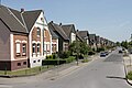
View along Robertstrasse

from Heydt Strasse

Steigerhaus on Karlstrasse


Further development

The settlement was privatized in the 1970s and its essential structure has remained unchanged until today. It is not a listed building, but is subject to municipal design statutes in order to preserve the external appearance.
Around 1980 a district project developed in the triangular settlement that became known nationwide. The Recklinghausen colliery was closed in 1977 and former miners and their families and other interested parties gathered a wealth of documents and materials on local history.
From this the Association for Mining and Industrial History Recklinghausen eV developed , which in 1990 acquired the remaining headframe "Konrad Ende" with the machine house and restored it with a lot of initiative and financial support from the city of Recklinghausen, the state of North Rhine-Westphalia and the European Union. Today there is a multicultural district center for Hochlarmark with rooms for celebrations and clubs, including the Vestische Tanzsportgemeinschaft and the Bürgererschützengilde Hochlarmark as well as a small museum area around the preserved steam engine.
The colliery site itself was converted into a district park. From there, access to the Hoheward dump is possible via the Dragon Bridge .
Individual evidence
- ^ Statutes of the city of Recklinghausen for the design of structures for the colliery settlement ( Memento of the original from February 14, 2011 in the Internet Archive ) Info: The archive link was automatically inserted and not yet checked. Please check the original and archive link according to the instructions and then remove this notice.
- ^ The Ruhr area: from the "golden" Middle Ages to industrial culture, by Thomas Parent, DuMont Reiseverlag, published April 2007, page 283
- ↑ City of Recklinghausen, Culture, Education, Sport, Flyer for the Museum of Mining and Industrial History ( Memento of the original from November 29, 2011 in the Internet Archive ) Info: The archive link was automatically inserted and not yet checked. Please check the original and archive link according to the instructions and then remove this notice.
Web links
Visitor center and anchor points (from west to east): Museum of German Inland Shipping | Inner harbor Duisburg | LVR Industrial Museum Oberhausen | Landscape Park Duisburg-Nord | Gasometer Oberhausen | Aquarius Water Museum | St. Antony Hut | Villa Huegel | Nordsternpark | Zeche Zollverein World Heritage Site and Zollverein Coking Plant | Ewald colliery | Marl Chemical Park | Railway Museum Bochum-Dahlhausen | Henrichshütte | Centennial Hall Bochum | Recklinghausen substation | German Mining Museum | Nightingale colliery | Henrichenburg ship lift | DASA | Hansa coking plant | Zeche Zollern II / IV | Hohenhof | Hagen Open Air Museum | Lindenbrauerei Unna | Maximilian Park Hamm
Themed routes (in ascending order by number): 1. Duisburg: City and Harbor | 2. Industrial cultural landscape Zollverein | 3. Duisburg: industrial culture on the Rhine | 4. Oberhausen: Industry makes the city | 5. Krupp and the city of Essen | 6. Dortmund: triad coal, steel and beer | 7. Industrial culture on the Lippe | 8. Erzbahn-Emscherbruch | 9. Industrial culture at Volme and Ennepe | 10. Brine, steam and coal | 11. Early industrialization | 12. The past and present of the Ruhr | 13. On the way to the blue Emscher | 14. Canals and shipping | 15. Lanes in the area | 16. Westphalian mining route | 17. Rhenish mining route | 18. Chemistry, Glass and Energy | 19. Workers' settlements | 20. Entrepreneur villas | 21. Bread, grain and beer | 22. Myth of the Ruhr Area | 23. Parks and Gardens | 24. Industrial nature | 25. Panoramas and Landmarks | 26. Sacred buildings | 27. Iron & Steel | 28. Water: works, towers and turbines | 29. Bochum - industrial culture in the heart of the district | 30. Gelsenkirchen | 31. Industrial Culture and Bauhaus Route | by bike
Centennial Hall Bochum ![]() |
Westpark |
Colosseum |
Mechanical workshops of the Bochumer Verein |
Stahlhausen settlement |
Bochum Transport Technology Association |
Ore rail link |
Ore railway |
Glückauf settlement |
United Carolinenglück colliery 2/3 |
Epiphany Church - Autobahn Church RUHR |
Dahlhauser Heide settlement
|
Westpark |
Colosseum |
Mechanical workshops of the Bochumer Verein |
Stahlhausen settlement |
Bochum Transport Technology Association |
Ore rail link |
Ore railway |
Glückauf settlement |
United Carolinenglück colliery 2/3 |
Epiphany Church - Autobahn Church RUHR |
Dahlhauser Heide settlement ![]() |
Ore Railway Bridge 4 |
Hannover Colliery 1/2/5 |
Workers' houses Am Rübenkamp |
Königsgrube settlement |
Ore Railway Bridge 6 |
Hanover Colony |
Erzbahnbrücke 9 - pillar bridge |
Kray Wanner Railway |
Alma coking plant |
Torhäuser, Schalke Club |
Chatten- / Preußenstraße settlement |
Ore Railway Bridge 10 |
Erzbahnbrücke 11 |
Ore Railway Bridge 13 |
Ore Railway Bridge 14 |
Pluto-Wilhelm colliery |
Consolidation 3/4/9 |
Graf Bismarck Colliery 1/4 |
Railway depot Gelsenkirchen-Bismarck |
Port of Grimberg |
Grimberger sickle |
Zeche Unser Fritz 1/4 |
Local museum Our Fritz |
Künstlerzeche Our Fritz 2/3 |
Rhine-Herne Canal |
Fleuthe Bridge |
Port Wanne-West |
Wanne-Eickel lock |
Recklinghausen training mine |
Recklinghausen Colliery I |
Recklinghausen II colliery |
Dreieck-Siedlung Hochlarmark |
Landscape Park Hoheward
|
Ore Railway Bridge 4 |
Hannover Colliery 1/2/5 |
Workers' houses Am Rübenkamp |
Königsgrube settlement |
Ore Railway Bridge 6 |
Hanover Colony |
Erzbahnbrücke 9 - pillar bridge |
Kray Wanner Railway |
Alma coking plant |
Torhäuser, Schalke Club |
Chatten- / Preußenstraße settlement |
Ore Railway Bridge 10 |
Erzbahnbrücke 11 |
Ore Railway Bridge 13 |
Ore Railway Bridge 14 |
Pluto-Wilhelm colliery |
Consolidation 3/4/9 |
Graf Bismarck Colliery 1/4 |
Railway depot Gelsenkirchen-Bismarck |
Port of Grimberg |
Grimberger sickle |
Zeche Unser Fritz 1/4 |
Local museum Our Fritz |
Künstlerzeche Our Fritz 2/3 |
Rhine-Herne Canal |
Fleuthe Bridge |
Port Wanne-West |
Wanne-Eickel lock |
Recklinghausen training mine |
Recklinghausen Colliery I |
Recklinghausen II colliery |
Dreieck-Siedlung Hochlarmark |
Landscape Park Hoheward ![]() with the dumps Hoheward / Hoppenbruch |
Emscherbruch |
Ewald colliery |
with the dumps Hoheward / Hoppenbruch |
Emscherbruch |
Ewald colliery |![]()
![]()

German Mining Museum |
Mountain School TFH Georg Agricola |
Federal Miners' Association |
Bergmannsheil |
Tippelsberg |
Julius Philipp colliery - Medical history collection in the Malakow Tower |
Brockhauser civil engineering colliery |
Peaceful neighbor colliery |
Alte Haase colliery |
Nightingale colliery |
Neu-Iserlohn coking plant |
Robert Müser Colliery , Arnold Shaft |
Lothringen colliery |
Zeche Zollern |
Landwehr Colony |
Hansa coking plant |
Westhausen colliery |
Adolf von Hansemann colliery |
Colliery Minister Stein / Neue Evinger Mitte |
Old colony of Eving with welfare building |
Landesoberbergamt Dortmund | Mining memorials on the Ostfriedhof |
Gneisenau colliery |
Müsersiedlung of the Gneisenau colliery |
Monopoly colliery , Grillo shaft |
Koenigsborn 3/4 colliery |
Maximilianpark |
Westphalia Colliery |
Zeche Sachsen - Eco-Center NRW |
Radbod colliery |
Radbod Colliery Memorial |
Kissinger Höhe |
East mine , Heinrich Robert shafts |
Lark shaft |
Werne colliery |
Monopol mine, Grimberg shaft 1/2 |
Heap of large wood |
Colliery House Aden |
Ziethenstrasse settlement |
Zeche Minister Achenbach , shaft 4 - LÜNTEC Tower |
Miners Residential Museum |
Waltrop colliery | Hammerhead tower Zeche Erin 3 |
Schwerin dump |
Erin colliery 7 |
Ewald Colliery Continuation |
Vestisches Museum |
Recklinghausen II colliery |
Dreieck-Siedlung Hochlarmark |
Landscape Park Hoheward with the dumps Hoheward / Hoppenbruch |
Ewald Colliery 1/2/7 |
Colliery mallets & iron 3/4/7 |
Colliery mallets & iron 5/6 |
Auguste Victoria mine , shaft 1/2 |
Auguste Victoria mine , shaft 3/7 |
Prince Leopold Mine |
Fürst Leopold settlement | Machine hall Zeche Zweckel |
RBH Logistics |
Halde Haniel |
Arenberg colliery continuation |
Tetrahedron |
Prosper II colliery |
Prosper coking plant |
Garden City Welheim |
Mottbruchhalde - "Halde im Wandel" |
Colliery Hugo |
Schüngelberg settlement |
Dump Rungenberg |
Bergmannsglück colliery |
Westerholt mine |
Nordsternpark |
Oberschuir shaft |
Consolidation 3/4/9 |
Graf Bismarck Colliery 1/4 |
Alma coking plant |
Settlement Flöz Dickebank |
Rheinelbe Science Park |
Stockpile Rheinelbe |
Colliery Holland 1/2 |
Colliery Holland 3/4/6 |
Zeche Unser Fritz 1/4 |
Local history and natural history museum Wanne-Eickel |
Pluto-Wilhelm colliery |
Hannover Colliery I / II / V |
Dahlhauser Heide settlement |
United Carolinenglück colliery 2/3 |
Flottmann halls | Kunstwald Zeche Teutoburgia |
Teutoburgia settlement![]()
![]()
![]()
![]()
![]()
![]()
![]()
![]()
![]()
![]()
![]()
![]()
![]()
![]()
![]()
![]()
![]()
![]()
![]()
![]()
![]()
![]()

Eisenheim settlement ![]() |
Stemmersberg settlement |
Grafenbusch settlement |
Ripshorster Strasse settlement |
Lohberg settlement |
Wehofen settlement |
Poets Quarter |
Hüttenheim settlement |
Margarethensiedlung |
Official housing estate Bliersheim |
Rheinpreußen settlement
|
Stemmersberg settlement |
Grafenbusch settlement |
Ripshorster Strasse settlement |
Lohberg settlement |
Wehofen settlement |
Poets Quarter |
Hüttenheim settlement |
Margarethensiedlung |
Official housing estate Bliersheim |
Rheinpreußen settlement ![]() |
Johannenhof settlement |
Meerbeck Colony |
Repelen settlement |
Old Friedrich-Heinrich settlement
|
Johannenhof settlement |
Meerbeck Colony |
Repelen settlement |
Old Friedrich-Heinrich settlement ![]() |
Niederberg Settlement - Old and New Colony |
Mining settlement Mausegatt |
Karnap settlement |
Margarethenhöhe
|
Niederberg Settlement - Old and New Colony |
Mining settlement Mausegatt |
Karnap settlement |
Margarethenhöhe ![]() |
Altenhof II settlement
|
Altenhof II settlement ![]() |
Brandenbusch settlement |
Carl Funke settlement |
Garden City Hüttenau |
Peaceful Neighbor Colony |
Dahlhauser Heide settlement
|
Brandenbusch settlement |
Carl Funke settlement |
Garden City Hüttenau |
Peaceful Neighbor Colony |
Dahlhauser Heide settlement ![]() |
Lange Riege settlement
|
Lange Riege settlement ![]() |
Walddorf settlement |
Cuno settlement |
Kreinberg settlement |
Vogelsang settlement |
Colliery settlement Neustadt Ahlen |
Rünthe express train settlement |
Victoria Settlement |
Ziethenstrasse settlement
|
Walddorf settlement |
Cuno settlement |
Kreinberg settlement |
Vogelsang settlement |
Colliery settlement Neustadt Ahlen |
Rünthe express train settlement |
Victoria Settlement |
Ziethenstrasse settlement ![]() |
Miners Residential Museum |
Müsersiedlung |
Mining official settlement Neu-Asseln |
Old colony of Eving
|
Miners Residential Museum |
Müsersiedlung |
Mining official settlement Neu-Asseln |
Old colony of Eving ![]() with welfare building |
Oberdorstfeld settlement |
Landwehr Colony |
Teutoburgia settlement
with welfare building |
Oberdorstfeld settlement |
Landwehr Colony |
Teutoburgia settlement ![]() |
Dreieck-Siedlung Hochlarmark |
Settlement Flöz Dickebank
|
Dreieck-Siedlung Hochlarmark |
Settlement Flöz Dickebank ![]() |
Klapheckenhof settlement |
Vittinghoff settlement |
Schüngelberg settlement
|
Klapheckenhof settlement |
Vittinghoff settlement |
Schüngelberg settlement ![]() |
Spinnstuhl settlement |
Garden City Welheim
|
Spinnstuhl settlement |
Garden City Welheim ![]() |
Zweckel settlement |
Fürst Leopold settlement
|
Zweckel settlement |
Fürst Leopold settlement

Villa Huegel ![]() |
Margarethenhöhe
|
Margarethenhöhe ![]() |
Krupp family cemetery | Association building of the Regionalverband Ruhr |
Become an abbey |
Horster mill |
Headquarters Krupp |
Zeche Zollverein Shaft XII |
Gasometer Oberhausen |
St. Antony Hut
|
Krupp family cemetery | Association building of the Regionalverband Ruhr |
Become an abbey |
Horster mill |
Headquarters Krupp |
Zeche Zollverein Shaft XII |
Gasometer Oberhausen |
St. Antony Hut ![]() |
Eisenheim settlement
|
Eisenheim settlement ![]() |
Landscape Park Duisburg-Nord
|
Landscape Park Duisburg-Nord ![]() |
Old Thyssen headquarters |
Alsumer Berg
|
Old Thyssen headquarters |
Alsumer Berg ![]() |
Haniel Museum |
Rhine orange |
Rheinpreußen settlement
|
Haniel Museum |
Rhine orange |
Rheinpreußen settlement ![]() |
Krupp Hüttenwerke Gate 1 |
Harbor mouth of the factory harbor of Hüttenwerke Krupp Mannesmann |
Kamp Monastery |
Streithof |
Landsberg Castle |
Henrichshütte
|
Krupp Hüttenwerke Gate 1 |
Harbor mouth of the factory harbor of Hüttenwerke Krupp Mannesmann |
Kamp Monastery |
Streithof |
Landsberg Castle |
Henrichshütte ![]() |
Hannover Colliery I / II / V | Bell of the Bochum Association in front of the town hall |
Kortumpark | Grave of Heinrich Kämchen |
Nightingale colliery
|
Hannover Colliery I / II / V | Bell of the Bochum Association in front of the town hall |
Kortumpark | Grave of Heinrich Kämchen |
Nightingale colliery ![]() |
Monument of Minister Stein at Rathaus Wetter |
Castle weather |
House Schede |
House Harkorten |
Hohenhof
|
Monument of Minister Stein at Rathaus Wetter |
Castle weather |
House Schede |
House Harkorten |
Hohenhof ![]() |
Borsigplatz | Mining memorials on the Ostfriedhof | Graves of the Hoesch family in the Ostfriedhof |
Monument to those who fell in March on the north cemetery in Eving ( Ruhr uprising ) |
Zeche Zollern |
Old Reichsstrasse 1 |
Emscher spring |
Radbod Colliery Memorial |
Cappenberg Castle |
Schwerin dump |
House Goldschmieding |
Hammerhead tower Zeche Erin 3 |
Kunstwald Zeche Teutoburgia |
Wanne-Eickel main station |
Halde Haniel |
Dreieck-Siedlung Hochlarmark |
Glückauf-Kampfbahn |
Graf Bismarck colliery 1/4 |
Schurenbachhalde
|
Borsigplatz | Mining memorials on the Ostfriedhof | Graves of the Hoesch family in the Ostfriedhof |
Monument to those who fell in March on the north cemetery in Eving ( Ruhr uprising ) |
Zeche Zollern |
Old Reichsstrasse 1 |
Emscher spring |
Radbod Colliery Memorial |
Cappenberg Castle |
Schwerin dump |
House Goldschmieding |
Hammerhead tower Zeche Erin 3 |
Kunstwald Zeche Teutoburgia |
Wanne-Eickel main station |
Halde Haniel |
Dreieck-Siedlung Hochlarmark |
Glückauf-Kampfbahn |
Graf Bismarck colliery 1/4 |
Schurenbachhalde![]()
![]()
![]()
![]()
![]()
Coordinates: 51 ° 33 '54 " N , 7 ° 10' 59.7" E