Hoheward dump
The Hoheward dump is a mine dump in the Ruhr area . It originated from beds of coal mine Recklinghausen II , the Ewald coal mine and coal mine General Blumenthal / Haard . Located between the towns of Herten and Recklinghausen , together with the Hoppenbruch heap , it forms the largest heap landscape in the Ruhr area. The highest point of the dump is with a height of 152.5 m above sea level. NN reached. The Hoheward and Hoppenbruch dumps are part of the Route of Industrial Culture and the Hoheward Landscape Park . Both piles are owned by the Ruhr Regional Association , which has taken over the areas from Deutsche Steinkohle AG. As the project sponsor, he is responsible for expanding the Hoheward dump. When visibility is good, the Rhine Tower in Düsseldorf, about 50 km away , can be seen.
overview
The heap has now been completely released to the public. The western part was poured and modeled until 2016. A trip around the heap at the level of the balcony promenade with a length of around 6.4 km offers views in every direction, supplemented by informative panorama boards on all 10 viewing balconies that were built along the promenade. For this purpose, the so-called promenade bridge was built in the formerly central access area on the southern slope of the heap . It spanned what was then the access road on which gravity trucks transported the tailings.
In the northwestern part of the heap, above the viewing balcony 1, there is the Ewald gallery , a steel viewing tower from which there is a very good view of the former colliery and the city center of Herten.
The construction of the heap caused a sensation in the 1980s. On the one hand, there was resistance for ecological reasons: it was feared that the dump would change the air flow. What was more serious, however, was that on Hohewardstrasse - the one from Herten-Süd to the industrial area where the RZR waste incineration plant is located today and that ran between the two original heaps - an unofficial residential area had formed after the war. Originally intended as emergency shelters and garden sheds, the houses were gradually illegally converted into respectable single and multi-family houses. A community of settlers was formed and an inn "rose garden" was built. The colliery railway already ran in the Hohewardstraße area. The disputes ended with a new settlement being built for all the settlers on Hohewardstrasse in Reitkamp, including a “Rosengarten” restaurant. After the settlement was established, all of the settlers on Hohewardstraße moved to Reitkamp. The colliery railway was moved into a tunnel, but has not been in operation since the colliery was closed in 2000. The tunnel is unique in that it was not built after the construction of the heap, as is usual for tunnels, but the tunnel was first built and then the heap was heaped over it.
Horizon observatory
The horizon observatory was built on the northern summit plateau in 2008. The modern structure consists of a circular, flat surface with a diameter of 88 m, a forum with a diameter of 35 m in the middle, lowered by 1.50 m, and two arches with a radius of approx. 45 m, which are like the great circles meridian and celestial equator span across the square. The horizon observatory is designed to represent a modern version of prehistoric stone circles and structures like Stonehenge . If the observer is exactly in the sunken center of the structure, the plateau of the dump spreads out in all directions like an artificial horizon and with the help of some bearing markers, the rising and setting of the sun can be observed on important calendar days such as summer solstice , winter solstice or the equinox . Using other special bearing marks, moon turns and the precession movement of the earth's axis can also be observed using fixed star bearings. The arches that span everything divide the sky into the eastern and western halves as well as the northern and southern hemispheres and therefore serve as a solar calendar during the day and as a guide to the starry sky at night with the help of a self-illuminating scale. The idea and conception of this building come from the Initiativkreis Horizontastronomie im Ruhrgebiet eV .
Shortly after the facility opened on December 20, 2008, cracks were discovered in the equatorial arch; on January 6, 2009, the facility was closed for safety reasons and the arch was temporarily supported by two additional pillars. Since then, the owner and the steel construction company Maurer Söhne have been arguing about the fault and the removal of the defect. In March 2010, the Bochum Regional Court appointed two experts. In 2013, repair work and wind load tests were carried out in order to obtain a basis for making decisions about how to proceed. The expectation of the regional court in Bochum, which had estimated "several months" for the report, was not fulfilled. Only after more than five years did the reviewers present their report in the summer of 2015; the way they presented the court caused a stir. The construction costs of the observatory amounted to around 2 million euros, the expert costs up to 2015 around 970,000 euros.
When the horizon observatory will be accessible again is not foreseeable. According to the report of June 20, 2015, however, the damage is greater than previously assumed. The building vibration is the cause of the cracks on the welds. It is assumed that it will cost between 1.9 and 5 million euros to maintain the structure. In this context, a demolition is not unlikely.
Dragon Bridge
The Drachenbrücke has connected the Hochlarmark district park (former site of the Recklinghausen II colliery ) and the triangular settlement behind it with the Hoheward dump since the beginning of 2008 . It was developed by Ralf Wörzberger . The bridge offers pedestrians and cyclists a curved crossing over Cranger Straße in the form of a dragon skeleton, the ribs of which serve as holders for the railing. The dragon's neck and head are turned back as if the dragon were looking down at its visitors. The length of the pylons above the carriageway to Cranger Strasse is 18 m and the width of the deck girders is 3.5 m. The opening of the 1.5 million euro building was delayed several times. The reasons for this included planning deficiencies and the increased construction costs due to the increased world market price for steel. Although the structure suggests a rather light construction, the total mass amounts to 198 tons. The dragon bridge is 165 meters long without the dragon head. It is worth mentioning that the bridge has repeatedly been the victim of vandalism in the past. The bridge was smeared with graffiti or locks were attached to the bridge, which had to be removed regularly.
Sundial with obelisk
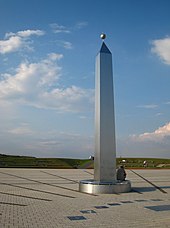
The approximately 3,000 m² horizontal sundial is located on the southern plateau at a height of about 140 m above sea level. NN . An eccentrically standing, 8.50 m high stainless steel obelisk serves as a pointer , which casts its shadow on the circular surface with a diameter of 62 m. The surface, which is based on the solarium of the Roman emperor Augustus , consists of light-colored paving stones. It is traversed by 20 cm wide strips of black plaster. This very precise design enables the visitor to read the time ( true local time ) and the date accurately in suitable weather . For this purpose, numerous explanations have been embedded in the area. A special feature is that the surface is absolutely flat. To prevent puddles from forming, porous plaster was used, through which the water gets into the ground.
Balcony promenade and sky stairs
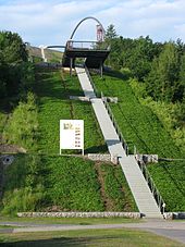
A structured system with paths, stairways, staircases and viewpoints grows on the heap, which enables access from all sides. In the lower area, an approximately six kilometer long balcony promenade has been created, which spans the entire dump and on which there are ten viewing balconies. From Salentinplatz, a staircase / staircase construction with 529 steps overcomes the approximately 110 meters in altitude to the horizon observatory.
A total of twelve staircases - like the digits on a clock - should lead up to the observatory around the heap from the city districts.
literature
- Wolfgang Berke : Over all mountains. The definitive stockpile guide in the Ruhr area. Klartext Verlag, Essen 2009, ISBN 978-3-8375-0170-4 , p. 72ff.
Web links
- Calculated 360 ° panorama ( U. Deuschle ; information ) from the Hoheward celestial observatory
- Description of all locations on this themed route as part of the Route of Industrial Culture
- Information on the Internet portal of the Regionalverband Ruhr
- Astronomical Java applets for the Obelisk and Horizon Observatory
Individual evidence
- ↑ The Hoheward landscape park on the private website halden.ruhr
- ↑ Ruhr area: Veba-Feuerlose and a tunnel without a mountain , on Drehscheibe-foren.de
- ^ Norbert Ahmann: Emscherbruch Landscape Park: Horizon Observatory on Hoheward is still closed . In: WAZ . January 3, 2012 ( waz.de [accessed January 16, 2020]).
- ^ Equatorial arches: Nothing happens, Hertener Allgemeine from December 26, 2010
- ^ A b Halde Hoheward: Two experts review the horizon observatory , Recklinghäuser Zeitung, March 28, 2010.
- ↑ The landmark on Hoheward was inaugurated in 2008 and has been broken since 2009 BILD during the large stockpile check , Bild Zeitung, September 25, 2013
- ↑ Thorsten Fechtner: Does the demolition only help now? Recklinghäuser Zeitung, July 7, 2015.
- ↑ Spektrum.de What's next on Halde Hoheward?
- ↑ Winterhager, Uta, Bonn: Dragon Bridge Culture on Halde . In: Bauwelt . Issue 16.2008, 2008, pp. 6–7 ( pdf [accessed on January 16, 2020]).
- ↑ Dragon Bridge , article on Structurae
- ^ Dragon Bridge Recklinghausen , Baukunst NRW
Coordinates: 51 ° 34 ′ 1.2 ″ N , 7 ° 10 ′ 1.2 ″ E


