Angerpark
The Angerpark is a landscape structure on the Heinrich-Hildebrand-Höhe in Duisburg - Angerhausen .
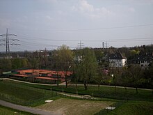
The 14-hectare Angerpark consists of the former slag dump of the Duisburg metal works and some adjacent rehabilitation areas that have been sealed and renatured. It forms the continuation of the landscape protection and recreation area Biegerhof -West and, with the Angerbach , the connection to the Rhine and the house Angerort located there . The state of North Rhine-Westphalia and the city of Duisburg raised a total of over 50 million euros for the renovation work and renaturation of the site of the former zinc smelter . At the end of 2008, the Angerpark was opened with a community festival by State Environment Minister Eckhard Uhlenberg , Lord Mayor Adolf Sauerland , City Director Peter Greulich and District Mayor Arno Müller.
description
The Angerpark consists of the Heinrich-Hildebrand-Höhe and a further 50,000 square meters of surrounding area, some of which had to be purchased by the city of Duisburg for this purpose. Essentially, these were the former factory car park, private green spaces, areas on Berzeliusstrasse and in Angerbachtal.
To design the green spaces, 350 tall trunks and 50,000–60,000 bushes and trees were planted, depending on the slope, oak, alder, willow, birch, ash and poplar were used. A good half of the green areas are laid out as litter meadow. The existing trees on the Angerbach were preserved, supplemented with local plantings and very steep slope areas on the edge of the former MHD factory premises were secured with gabions .
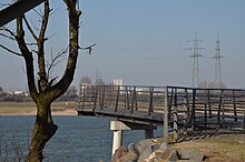
A total of almost 5 kilometers of hiking trails were laid out on the height, in the park and by the stream. The 1.6 km long foot and bike path along the Angerbach leads from Mündelheimer Straße over the Angerpark to the "Rheinportal Angerort" viewing platform opposite Haus Angerort, which is also part of the renovation project. Along the Bachweg, the Huckingen citizens' association put up panels with information about the Medefurter or Angerorter mill and the Angerort house. This gives it a connection to the historic hiking trail in Angerland.
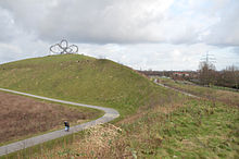
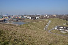
The network of paths in the park is partly paved and partly paved with hard limestone gravel. It completely circles the Heinrich-Hildebrand-Höhe and spirals up to the summit. The path and summit plateau are equipped with park benches. From the summit you have a good view of the south of Duisburg, the Rhine and the surrounding industrial plants.
Emergence
In August 2005 Metallhütte Duisburg filed for bankruptcy, in October the resolution of the creditors' meeting was up for execution, in the following year the city of Duisburg bought both the factory site with all buildings and contaminated sites as well as the landfill. In July 2006, the demolition work and the land recycling began, in September the landscaping at the landfill to be dumped in the Heinrich-Hildebrand-Höhe, in mid-2007 the topping-out ceremony was celebrated on the height. At the end of 2007, the demolition work was completed and the site was ready for construction, in October 2008 the Angerpark was completed and it could be opened on November 7th. Most of the former factory site of the Duisburg metal works was converted into the neighboring logport II logistics center on the Rhine, while a smaller part was designated as an industrial park on Ehinger Straße.
costs
The costs for the closure and sealing of the landfill, including the purchase of the land, amounted to around 8 million euros. The installation of the Angerpark, the network of paths and the Angerort Rhine portal cost 2 million euros, and this totaled 10.3 million euros. The project was publicly funded with a total of around 9.5 million euros, the funds came from the " Ecology Program in the Emscher-Lippe Area (ÖPEL)".
The investments on the former site of the Duisburg metalworks, including the elimination of environmental hazards and the development of the new logistics area, amounted to around EUR 47 million up to 2008.
Heinrich-Hildebrand-Höhe
The new survey is formed from
- the former plant landfill operated from 1905 to 2008 (contained the residues from the smelting of zinc ores),
- the less contaminated excavation of the renovated factory premises (higher contaminated excavation was transported to special landfills)
- and the uncontaminated rubble from the demolished factory buildings.
During the landfill closure from 2006 to 2008, a total of 1.8 million tons of material was moved. The volume of the heap itself is around 1 million cubic meters and the stand area is 90,000 square meters. The height above street level is 35 meters, and 67 meters above sea level. The trail network on the heap is 2.7 km long.
To seal off the landfill site, 2.5 millimeters thick, long-term-resistant plastic sealing sheeting is used 3 meters below the surface of the debris. The multi-layer waterproofing system is protected by geotextiles , above which a drainage system is attached for drainage. A layer more than 2 meters thick with natural soil forms the end.
The drainage takes place via the drainage system and the trenches on the paths leading to the summit in two rain retention basins. From there it is directed into the Angerbach. The retention basin makes an important contribution to flood protection on the lower reaches of the Angerbach.
The height is named after the local researcher Heinrich Hildebrand, who died in 2004. There is a plaque on the summit that honors his services to local history.
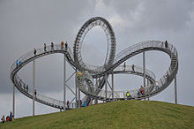
Tiger and Turtle - Magic Mountain
In 2011 the large sculpture modeled on a roller coaster was set up by the artist duo Heike Mutter and Ulrich Genth on the summit of the Halden, originally planned for the Ruhr.2010 Capital of Culture year . The sculpture is 20 meters high, the highest accessible point is 13 meters above the level of the landfill. At night it is illuminated with 880 LED lamps, in bad weather or black ice the entrance is closed, the looping itself may not be used. The construction costs totaled 2 million euros, only 1.4 million were planned.
Web links
- Description of this sight on the route of industrial culture
- City of Duisburg: "40-page brochure traces the redevelopment of the MHD Sudamin site" , accessed on January 26, 2011
Coordinates: 51 ° 22 ′ 33.3 " N , 6 ° 44 ′ 13" E


