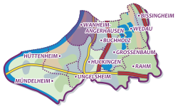
Wanheim-Angerhausen
|
|||
|---|---|---|---|
| map | |||

|
|||
| Basic data | |||
| Coordinates : | 51 ° 23 '2 " N , 6 ° 44' 37" E | ||
| Area : | 3.77 km² | ||
| Postal code : | 47249 | ||
| Area code : | 0203 | ||
| population | |||
| Residents : | 12,821 (Dec. 31, 2017) | ||
| Population density : | 3397 inhabitants / km² | ||
| Proportion of foreigners : | 20% (2564) | ||
| structure | |||
| District : | Duisburg-South | ||
| District number: | 704 | ||
| Incorporation : | April 1, 1902 | ||
Wanheim-Angerhausen is a district of Duisburg in the Duisburg-Süd district . 12,821 people live in the district on 377.4 hectares (as of December 31, 2017).
history
The place is mentioned as Wagenheim and Angerohuson as early as 1052 in a document from the Werden Abbey . Wanheim, which lies directly on the Rhine , and Angerhausen, which adjoins it to the southeast, belonged to the Duisburg council villages . In church terms, however, the two villages had been assigned to Friemersheim on the left bank of the Rhine since the 12th century . Bounded by the Rhine, Angerbach and Bergischer Landwehr , the place formed a Klevian enclave in the Duchy of Berg , to which it belonged during the Napoleonic rule from 1805 to 1815. Under the subsequent Prussian administration , he belonged to the mayor's office of Duisburg-Land. In 1902 the community of Wanheim-Angerhausen was incorporated into the Duisburg district.
The former oak grove between Wanheim and the city of Duisburg, located in the Bergisch area, is the place where the French revolutionary troops crossed the Rhine on the night of September 5th to 6th, 1795. The Austrian troops allied with the Duchy of Berg had to retreat and the French were able to secure their rule on the right bank of the Rhine. The stairway that they used after crossing the Rhine is still called "Franzosenweg" to this day.
In the 1960s, the banks of the Rhine in Wanheim were expanded and in the 1980s the Rheinuferpark was created with a rose garden, quiet meadows and children's playgrounds.
On July 13, 1988, the IRA carried out an attack on a barracks (Glamorgan Barracks) of the British Army on the Rhine in Wanheim, in which 9 British soldiers were slightly injured. In 1993 the military base was closed.
Industry
In 1873, when two steam sawmills set up on the banks of the Rhine, industrialization began. In 1905 the Metallhütte Aktiengesellschaft Duisburg was founded , in 1911 the Wanheimer Eisenwerke, a foundation of the Bayerische Maschinenfabrik Augsburg-Nürnberg (MAN) . The ironworks were last part of the ThyssenKrupp group , but were sold to the Indian Sona Group in 2008 and now operate under the name of SONA BLW Präzisionsschmiede , Duisburg plant.
Energy infrastructure
The Rhine overhead line crossing Duisburg- Wanheim crosses the Rhine in Wanheim . Stadtwerke Duisburg operates the combined heat and power plant III , a combined cycle plant , in Wanheim .
Attractions
See architectural monuments in Wanheim-Angerhausen in the list of architectural monuments in Duisburg-Süd .
Web links
Individual evidence
- ↑ a b Population statistics of the city of Duisburg from December 31, 2017 (PDF; 21 kB)
- ^ LAC I, document 188.
- ^ Community encyclopedia for the Kingdom of Prussia 1885
- ^ Official journal for the administrative district of Düsseldorf 1902, p. 119
- ↑ Tagesschau from July 13, 1988, from 2:50 minutes
