
Hochemmerich
|
||||
|---|---|---|---|---|
| map | ||||

|
||||
| Basic data | ||||
| Coordinates : | 51 ° 24 ′ 56 " N , 6 ° 42 ′ 45" E | |||
| Height : | 30 m above sea level NN | |||
| Area : | 5.57 km² | |||
| Postcodes : | 47226, 47228 | |||
| Area code : | 02065 | |||
| population | ||||
| Residents : | 18,250 (Dec. 31, 2016) | |||
| Population density : | 3276 inhabitants / km² | |||
| Proportion of foreigners : | 30% (5469) | |||
| Residential building : | 3145 | |||
| Apartments : | 9000 | |||
| structure | ||||
| District : | Rheinhausen | |||
| District number: | 602 | |||

Hochemmerich with 18,250 inhabitants (as of December 31, 2016) is one of the old town centers of the city in 1934 formed Rheinhausen that to on 1 January 1975. Duisburg district Rheinhausen was.
Parish, parish, mayor's office, district


In the course of time the meaning of the name Hochemmerich changed. Hochemmerich has existed as a parish ( parish ) since around 900, as a mayor's office (with the communities of Hochemmerich, Bergheim and Oestrum at least from 1798).
A jury in Hochemmerich is mentioned for the year 1343. An order of the St. Sebastian Schützen Brotherhood was recorded in 1603. Before the French occupation, the area belonged to the County of Moers . Between 1794 and 1814, the region was under Napoleon French territory, u. a. the Civil Code was introduced here. The occupation by Prussian troops took place on December 6, 1813. When the left bank of the Rhine was again passed to Prussia as a result of the Congress of Vienna (1815), the canton of Moers with Hochemmerich came to the administrative district of Kleve of the Cologne provincial administration . Hochemmerich came to the Rheinberg district in 1816 and after its dissolution in 1823 to the Geldern district . Friemersheim belonged to the Krefeld district and came with Hochemmerich in 1857 to the newly formed Moers district . From 1819 to 1901 the mayor's office Hochemmerich was run in personal union with the mayor's office of Homberg.
On April 1, 1921, the communities of Hochemmerich, Bergheim and Oestrum merged to form the community of Hochemmerich and on April 6, 1923, the communities of Hochemmerich and Friemersheim were united by ministerial decree to form the largest rural community in Prussia under the name Rheinhausen, which had been a small peasantry until then . which joined the village of Werthausen to the east. Both belonged to the mayor's office of Hochemmerich (referred to as "Amt" Rheinhausen from January 1, 1928).
On July 1, 1934, the community of Rheinhausen received city rights . Hochemmerich was one district among others in the city of Rheinhausen (e.g. Asterlagen, Bergheim, Oestrum, Trompet). With the dissolution of the Moers district and the incorporation into Duisburg on January 1, 1975 (to the Rheinhausen district together with the Rumeln-Kaldenhausen community ), the districts within the districts were redefined. Hochemmerich now became the north-eastern part of the Rheinhausen district (including the eastern part of Asterlagen with the district number 602, the southern part became Rheinhausen-Mitte ).
mayor
Mayors of Hochemmerich were:
- January 23, 1798 to 1807: Arnold Fusten (initially Munzipilagent, from 1800 Maire, * 1737, † July 23, 1827)
- 1807 to 1813: Heinrich (Henri) Krämers (* November 12, 1774 † July 23, 1827)
- 1813 to 1815: Arnold Berns (* December 3, 1760, † February 10, 1828)
- 1815 to 1819: Peter Heckhoff (born September 1, 1762, † 1841)
- 1819 to May 15, 1861: Friedrich Wilhelm Daubenspeck (in personal union with Homberg), (* September 19, 1790, † August 21, 1867)
- May 15, 1861 to February 14, 1865: Julius Hasbach (in personal union with Homberg), (* July 2, 1816, † February 2, 1876)
- February 6, 1866 to October 1, 1900 Franz Lauer (in personal union with Homberg), (* 1831, † April 6, 1918)
- June 7, 1901 to April 6, 1923: Leberecht Friedrich August Graeßner (* March 1, 1864, † March 1, 1939)
Districts
Alt-Hochemmerich
The heart of the old Hochemmerich is the Christ Church, which was consecrated to St. Peter until the Reformation in 1574 . The oldest predecessor of today's Christ Church dates from the 8th century and was a hall church about 6 × 8 m in size. At that time it belonged to the sphere of influence of Werden Abbey, in the south of today's city of Essen.
About 300 m southwest of the church existed in the 5th – 7th centuries. Century a Franconian burial ground, of which individual remains have been uncovered again and again since 1928. The first documentary mention of the place (as Embriki ) and a church can be found in a lift register of the Reichsabtei Werden from around 890.
In the course of the expansion of Krupp 's ironworks and with it the population growth in the surrounding villages, Hochemmerich grew into the center of the local retail trade and is still the focus of retail trade in Rheinhausen today, especially with the twice-weekly weekly market that has existed since March 1901. The bucket ("Emmer") in the Rheinhausen city arms symbolizes this district.
Asterlagen
Atrop
Atrop lies in the south of Hochemmerich between Rheinhausen-Mitte and the Rhine , bounded by the Wesel-Duisburg-Mönchengladbach railway line . The center is located on Atroper Straße. It consisted of around 10 farms that had already settled in around 900. The most famous court was Heinrich Köhnens, who ran the Kronenbrauerei on Atroper and Hochfelder Strasse from 1868 to 1919. Parts of the Margarethensiedlung , a workers' settlement, built around the turn of the 19th and 20th centuries, also belong to the district. In the years 1902/03 the Atroper-, Schwarzenberger-, Friedrich-Alfred-, Eisen-, Industrie-, Gustav-, Adolf-, Andreas-, Eugen-, Klara-, Barbara- and Rosastraße as well as at Kruppplatz with the Construction of the settlement started. With Rheinhausen Ost Atrop owns one of the four connections of the Deutsche Bahn Rheinhausen. Several bus lines connect the district with Moers and Duisburg. Atrop is located directly at the Logport, a center for logistics companies, which was built on the site of the former Rheinhausen iron and steel works .
Werthausen
The small district, located directly on the Rhine dike, is known for the former Werthauser ferry, known since the Middle Ages , which instead of today's bridge of solidarity connected Hochfeld and Werthausen. The small fort in Werthausen from Roman times is also documented by archaeological finds. The name Werthausen (formerly Werthuisen ) means the house on the Werth (island) . In Werthausen there is the listed old ferry house (built in 1791); From 1888 to the 1960s, the Lenzen grain distillery and liqueur factory was located on Deichstrasse in Werthausen .
Rheinhausen
South of value Hausen lay peasantry Rheinhausen (formerly Rynhuessen), after which the community since 1923 and the city was named for the 1934th The peasantry is first mentioned in 1250, it consisted of a few yards and had about one dozen Ride . In 1445 the main courtyard was the fief of the Werden Abbey to Johann von Rynhusen. No remains of it have survived; parts of the Margarethensiedlung mentioned above have built over it.
Rheinhausen-Mitte
After the municipal reorganization in 1975, the southern part of Hochemmerich became a separate district called Rheinhausen-Mitte . It includes the area around the town hall and the musicians and poets quarters.
Buildings and sights
- Christ Church (built 1447)
- Diergardtpark
- Old ferry house in Werthausen (built 1791)
- Margarethensiedlung (built from 1903)
- St. Peter (built 1914)
- Rheinhausen-Hochfeld bridge over the Rhine (built in 1936); since 1988 renamed the Bridge of Solidarity
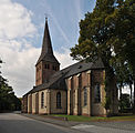
Evangelical Christ Church in the heart of Hochemmerich (1447)

St. Peter, Schwarzenberg (1914–1915)

Krupp cruet Rheinhausen-Hochemmerich, 1914

Bridge of Solidarity with a view towards Hochemmerich

Rhine panorama

_Nordseite.jpg)


Mayor's office building
The entire administration of the mayor's office in Hochemmerich (consisting of the mayor, a secretary, an apprentice and 2 policemen) found space in 2 living rooms in the Altenschmidt house on Asterlager Straße from 1901, during the registration office in the Kirchstrasse house. 8 was housed. Due to the rapidly expanding Krupp factory, these rooms were only makeshifts. On October 17, 1901, the district administrator of the district of Moers issued the instruction to obtain offers for a specially built mayor's building. The building permit for the building at Moerser Straße 26 (Kommunalweg from Hochemmerich to Oestrum) was granted on April 22, 1902.
On May 25, 1903, the mayor's office in Hochemmerich moved into the newly constructed building at Moerser Straße 26, which until 1929 housed the municipal administration and later a school and for many years was the seat of a branch of the Duisburg Institute for Youth Welfare, a municipal advisory service. After this has moved into the premises of the Rheinhausen District Office, the building is empty. On November 4, 2014, the Rheinhausen district council added it to the list of monuments under the Monument Protection Act (North Rhine-Westphalia) .
traffic
Local public transport in the Hochemmerich district has been operated by the Duisburger Verkehrsgesellschaft (DVG) since it was incorporated . Some of the lines are operated in joint traffic with NIAG Niederrheinische Verkehrsbetriebe .
A central transfer hub is the Hochemmerich market square. The bus lines 912, 914, 921, 922, 923, 924, 937, the express bus SB 42, the night lines NE2 and NE27 and the line 927 operated by the Krefeld transport company run through Hochemmerich. The line 912 largely follows the route of the previous tram line 2 (crooked line) from Homberg to Friemersheim, which ran from 1908 to 1954.
There is no train station in the Hochemmerich district. The Rheinhausen train stations are located in the districts of Rheinhausen-Mitte ( Rheinhausen Ost stop ), Friemersheim ( Rheinhausen train station ), Bergheim ( Trompet train station ) and Rumeln ( Rumeln train station ).
Dialect and colloquial language
Hochemmerich (like Rheinhausen as a whole) is located in the Lower Franconian dialect north of the so-called Uerdinger line , which runs from the Rhine via Kempen to Venlo . This dialect line (also called ek-ech border) separates the southern Lower Franconian (which is spoken in Uerdingen and Krefeld, for example, with the pronunciation of “esch” for the personal pronoun “I”) from the northern Lower Franconian Platt, which is in the Krefeld district Hüls (see Hölsch Plott ) begins and is (or was) spoken in different variants throughout the northern Lower Rhine - with the pronunciation of “ek” instead of “I”.
The Rheinhausen dialects are influenced by the Moers “Grafschafter Platt”, but differ from one another in the individual districts. However, the dialect is rapidly disappearing and is hardly understood by the younger generation. Instead, a “new” colloquial language prevails, the so-called “Lower Rhine German”, called “Regiolekt” by linguists. Although it is based on Standard German, it has special characteristics due to the inclusion of expressions from immigrants or words of youth language . The miner's language has also left its mark on everyday language. Many know the saying of: "..da hate abber Futtsack off" (the term. Futtsack indicates that something "went wrong" It comes from the time when yet. Pit pony worked underground, which in difficult conditions with have been immobilized in the feed bag .)
sons and daughters of the town
Theodor Timmermann (1627–1700), born in Hochemmerich, was a pharmacist , mayor of Mannheim and mayor of the Palatinate colony of Magdeburg .
literature
- Aletta Eßer, Klaus de Jong: Rheinhausen in old pictures . Volume 1, 1978, ISBN 3-88265-020-6
- Aletta Eßer, Klaus de Jong: Rheinhausen in old pictures . Volume 2, 1979, ISBN 3-88265-032-X
- Michael Gey, Klaus de Jong: Rheinhausen in old pictures. Volume 3, 1984, ISBN 3-88265-118-0
- Rudolf Lisken: Rheinhausen in old views . Zaltbommel (NL) 1994, ISBN 90-288-5898-9
- Rudolf Lisken: My hometown Rheinhausen in pictures, then and now . (Volume 1 and 2)
- Friedrich Albert Meyer: Rheinhausen am Niederrhein in the historical process. A house and handbook for the Rheinhauser area . Series of publications by the city of Rheinhausen, Volume 1, 1956
- Friedrich Albert Meyer: The land acquisition of industry in the Rheinhauser area . Series of publications by the city of Rheinhausen, Volume 3, 1965
- Friedrich Albert Meyer: From the Ruhr over the Rhine. Rheinhausen's heavy industry . Series of publications by the city of Rheinhausen, Volume 4, 1966
- Friedrich Albert Meyer: Rheinhauser stories . Steiger, Moers 1979, ISBN 3-921564-21-2
- Monika Nickel-Schäfer / Helmut Motz: Our Mayors , yearbook of the districts of the city of Duisburg on the left bank of the Rhine (Ed .: Freundeskreis lively Grafschaft), 1992/93, p. 14 ff.
- Harald von Rheinhausen: Rheinhauser Geschichtstriologie, Volume 1 (Hochemmerich), self-published 2014, without ISBN
- Klaus Sefzig: Rheinhausen An illustrated book with photos by Hans-Ulrich Kreß. Editor Linda Broszeit. (Book Island) With English and Turkish captions. ISBN 3-934572-82-0
- Contemporary witness exchange Duisburg ev: Rheinhausen , Sutton Verlag Erfurt 2013, ISBN 978-3-95400-152-1
Individual evidence
- ↑ Population statistics of the city of Duisburg from December 31, 2016 (PDF; 21 kB)
- ^ Federal Statistical Office (ed.): Historical municipality directory for the Federal Republic of Germany. Name, border and key number changes in municipalities, counties and administrative districts from May 27, 1970 to December 31, 1982 . W. Kohlhammer, Stuttgart / Mainz 1983, ISBN 3-17-003263-1 , p. 291 .
- ^ Official Journal for the Düsseldorf District 1921, p. 147
- ↑ Official Gazette for the Düsseldorf administrative region 1923, p. 159
- ^ Günther Binding : Archaeological investigations in the Christ Church Rheinhausen-Hochemmerich . Rhenish excavations 9. Düsseldorf 1971, pp. 111-133.
- ^ Frank Siegmund: Merovingian time on the Lower Rhine, Rheinische Ausgrabungen 34. Rheinland-Verlag, Cologne 1989, pp. 304-309.
- ↑ Erich Wisplinghoff: The room of Friemersheim. Rheinhausen 1961, p. 6 f.
- ^ Rheinhausen mining terms. Archived from the original on January 2, 2011 ; accessed on January 1, 2013 .
Web links
- Rheinhausen - a little city history
- Timeline of Hochemmerich
- Street directory of the district Hochemmerich (onlinestreet)
- Photo from the Hochemmerich market from 1962 (digit.wdr.de)
- Photo of Paulstrasse in Hochemmerich 1962 (digit.wdr.de)
Aldenrade | Old town | Baerl | Beeck | Beeckerwerth | Bergheim | Bissingheim | Bruckhausen | Buchholz | Dellviertel | Duissern | Fahrn | Friemersheim | Großenbaum | Alt-Hamborn | Hochemmerich | High field | Hochheide | Homberg | Huckingen | Hüttenheim | Kasslerfeld | Laar | Marxloh | Meiderich | Mündelheim | Neudorf | Neuenkamp | Neumühl | Obermarxloh | Overbruch | Cream | Rheinhausen-Center | Röttgersbach | Ruhrort | Rumeln-Kaldenhausen | Ungelsheim | Old Walsum | Vierlinden | Wanheim-Angerhausen | Wanheimerort | Wedau | Wehofen