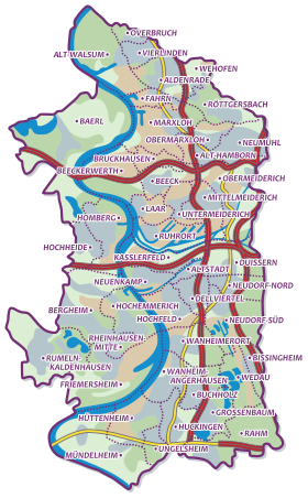
The city of Duisburg consists of 46 districts , which are divided into 7 districts . The city districts are numbered in steps of one hundred, starting with 100. The city districts of a city district are numbered consecutively, starting with the first number after the district number.
As of December 31, 2018 Telephone code, unless otherwise stated, is: 0203.
City districts (overview)
number
Surname
District Office
Residents
Inhabitants per km²
Area in ha
100
Walsum 91
50,604
2,398
2.110
200
Hamborn 92
75,626
3,620
2,089
300
Meiderich / Beeck 93
73,095
2,414
3,028
400
Homberg-Ruhrort-Baerl 94
41,153
1.110
3,706
500
Duisburg center 95
111.278
3,181
3,498
600
Rheinhausen 96
78.060
2,018
3,868
700
Duisburg-South 97
73.123
1,467
4,984
total
502.939
2,160
23,283
District 100: Walsum
number
Surname
Residents
Area in ha
Inhabitants per km²
Post Code
101
Vierlinden 12.007
228
5,266
47178
102
Overbreak 5,076
102
4,976
47178
103
Old Walsum 4,320
963
449
47178
104
Aldenrade 14,140
370
3,822
47169, 47179
105
Wehofen 7,397
238
3,108
47179
106
Drive 7,664
210
3,650
47169
total
50,604
2.110
2,398
number
Surname
Residents
Area in ha
Inhabitants per km²
Post Code
201
Röttgersbach 11,934
439
2,718
47167, 47169
202
Marxloh 20,879
758
2,754
47166, 47167, 47169
203
Obermarxloh 13,708
209
6,559
47166, 47167
204
Neumühl 17,994
473
3,804
47167
205
Old Hamborn 11,111
211
5,266
47166, 47137
total
75,626
2,089
3,620
number
Surname
Residents
Area in ha
Inhabitants per km²
Post Code
301
Bruckhausen 5,684
196
2,900
47166
302
Beeck 11,344
300
3,781
47139
303
Beeckerwerth 3,748
762
492
47139
304
Laar 6,472
254
2,548
47119
305
Underworld 10,066
255
3,947
47137
306
Mediterranean rich 18,404
369
4,988
47137
307
Obermeiderich 17,377
893
1,946
47138
total
73,095
3,028
2,413
number
Surname
Residents
Area in ha
Inhabitants per km²
Post Code
prefix
401
Ruhrort 5,746
541
1,062
47119
0203
402
Alt-Homberg 14,971
714
2,097
47198
02066
403
Hochheide 15,451
320
4,828
47198
02066
404
Baerl 4,985
2.131
234
47199
02841
total
41,153
3,706
1.110
number
Surname
Residents
Area in ha
Inhabitants per km²
Post Code
501
Old town 8,571
125
6,857
47051
502
Neuenkamp 5,167
257
2.011
47059
503
Kasslerfeld 3,892
416
936
47059/1
504
Duissern 15,509
489
3,172
47058
505
Neudorf-Nord 14,102
314
4,491
47057
506
Neudorf-Süd 12,575
757
1,661
47055
507
Dellviertel 14,409
262
5,500
47051, 47053, 47057
508
High field 18,696
378
4,946
47053
509
Wanheimerort 18,357
499
3,679
47055
total
111.278
3,498
3,181
number
Surname
Residents
Area in ha
Inhabitants per km²
Post Code
prefix
601
Rheinhausen-Mitte 10,627
142
7,484
47226
02065
602
Hochemmerich 17,766
494
3,596
47226
02065
603
Bergheim 20,339
957
2.125
47228
02065
604
Friemersheim 12,179
1,266
962
47229
02065
605
Rumeln-Kaldenhausen 17,149
1.009
1,700
47239
02151
total
78.060
3,868
2,018
number
Surname
Residents
Area in ha
Inhabitants per km²
Post Code
701
Bissingheim 3.139
97
3,236
47279
702
Wedau 5.101
478
1,067
47279
703
Buchholz 14,428
352
4,099
47249/47279
704
Wanheim-Angerhausen 12,193
378
3.226
47249
705
Great Tree 10.126
395
2,564
47269
706
cream 5,897
821
718
47269
707
Huckingen 9,553
449
2.128
47259
708
Huettenheim 3,509
554
633
47259
709
Ungelsheim 3,035
169
1,796
47259
710
Mündelheim 6,142
1,292
475
47259/40489
total
73.123
4,984
1,467
Web links swell
↑ Population statistics of the city of Duisburg from December 31, 2018
<img src="https://de.wikipedia.org//de.wikipedia.org/wiki/Special:CentralAutoLogin/start?type=1x1" alt="" title="" width="1" height="1" style="border: none; position: absolute;">
