
Bergheim (Duisburg)
|
||||
|---|---|---|---|---|
| map | ||||

|
||||
| Basic data | ||||
| Coordinates : | 51 ° 25 ′ 0 ″ N , 6 ° 41 ′ 0 ″ E | |||
| Area : | 9.57 km² | |||
| Postal code : | 47228 | |||
| Area code : | 02065 | |||
| population | ||||
| Residents : | 20,441 (Dec. 31, 2016) | |||
| Population density : | 2136 inhabitants / km² | |||
| Proportion of foreigners : | 9.21% (1882) | |||
| structure | ||||
| District : | Rheinhausen | |||
| District number: | 603 | |||
| Incorporation : | 1st January 1975 | |||

Bergheim is a district of Duisburg in the Rheinhausen district . Bergheim has 20,441 inhabitants ( as of December 31, 2016 ).


location
Bergheim is on the left bank of the Rhine and borders the other parts of the city of Rheinhausen, namely Rumeln-Kaldenhausen with the Toeppersee leisure area and Friemersheim and Rheinhausen-Mitte to the south, and Hochemmerich to the east . In the north of Bergheim are the Duisburg districts of Homberg and Hochheide . These belong to the district of Duisburg-Homberg / Ruhrort / Baerl . In the west of Bergheim is the city of Moers , Asberg district .
Naming and districts
Bergheim is named after the slight hill on which the place is located (area around the water tower). Today's Bergheim district includes the districts of Oestrum , Trompet and Winkelhausen, the latter in the valley of a former arm of the Rhine .
To the district belong to the north, the commercial areas "Business Park Asterlagen" with the mail center 46/47 and the industrial area Mevissen on the former colliery site of mine Wilhelmine Mevissen that until 30 June 1973 by 1,914 coal encouraged to continue in the east of Rheinhauser people park Founded between 1928 and 1930 as Hindenburgpark, it was considerably expanded between 1955 and 1957 and is also the seat of the Johanniter Hospital , which went into operation in 1962 . On the site of the former Schrooten steam brickworks on Flutweg, which was founded in 1857 and closed in 1963 , the Krupp-Gymnasium and Heinrich-Heine-Gesamtschule schools, which were in operation in the 1960s and 1970s, are located.
history
Early history
The Duisburg city archeology has been able to uncover an extensive urn field from the Iron Age (approx. 700–500 / 450 BC) in Bergheim in recent years . A total of 140 grave sites were found and secured. These urn finds and other findings that prove a settlement in the immediate vicinity prove that Bergheim was already settled two and a half millennia ago.
The Roman camp Asciburgium and the old Roman road ( B 57 ) were located in the immediate vicinity of Bergheim, in the Moers area (Moers-Asberg), partly also in the Bergheim area ( district Oestrum ).
The area of the old Roman fort near today's settlement areas in Asberg and Oestrum was directly on the left side of an old Rhine bend, which began to silt up in the first century. Some areas that belong to Bergheim today, such as B. Winkelhausen, historically lay within the loop on the right side of the Old Rhine.
The extensive silting up of the Rhine loop and the associated deterioration in the supply situation ultimately led to the abandonment of the fort around AD 86 and the establishment of the small fort in Werthausen in the area of neighboring Hochemmerich, near the main river.
The area around Bergheim was therefore in the area of the Lower Germanic Limes for centuries , i.e. H. Border area of the Roman Empire to Germania magna , the Great Germania (east of the main river of the Rhine).
middle Ages
After the fall of the Western Roman Empire , Bergheim became part of the Franconian Empire . Bergheim was first mentioned in a document from the time of transition from the Franconian Empire to Lotharii Regnum (the middle kingdom of Emperor Lothar I ) in the 9th century. The place appears as Berghem in the arable land of Werden Abbey . Oestrum ( Ostarhem ) also appears in this early source. A Christianus de Berghem appears in an income directory of the Werden Provost's chapel in Asterlagen from the period between 1097 and 1105 . In the same place Winkelhausen ( Winkilhuson ) is also mentioned. In 1250 again in appear lifting register of the Werden provost court Asterlagen a Godefricus de Bergheim .
18th and 19th centuries
Subsequently, Bergheim belonged to the county of Moers for many centuries in the Holy Roman Empire . In 1702 Bergheim and the county of Moers fell to Prussia as part of a succession . Between 1794 and 1814, the region was under Napoleon French territory, u. a. the Civil Code was introduced here. From 1814, as a result of the Congress of Vienna , the region again belonged to Prussia (as part of the Rhine Province ).
The rural community Bergheim (in the southern part of today's district) and the northern rural community Oestrum as well as the farming communities Asterlagen , Winkelhausen and Trompet (with the train station opened in 1849) belonged to the Rheinberg district since 1816 , to the Geldern district since 1823 and since it was founded in 1857 to the district of Moers . Since 1794 the area was part of the mayor's office Hochemmerich .
20th century
Bergheim was incorporated into Hochemmerich together with Oestrum on April 1, 1921. Since 1923 Bergheim was part of the municipality Rheinhausen , which received city rights in 1934. During this time, a large rental apartment building took place in Bergheim, especially by the mining company. Around the Schauenplatz there are still listed, partly stately buildings from the colliery settlement, which were built around 1927. Today, the Rheinhausen mining collection near the Bergheim water tower is a reminder of mining history .
The Bergheim volunteer fire brigade was also founded in 1923.
It was not until the municipal reorganization , which came into effect on January 1, 1975, that Bergheim finally became a Duisburg district with its current regional layout.
Many residents today have a migration background . The property "In den Peschen 3–5", which became known in the media in 2012 as the so-called "problem house", was inhabited by many people from Southeastern Europe until January 2014.


Buildings
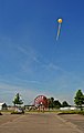
- Bergheim water tower
- Bergheim windmill, built in 1794
- Trompet station building, built in 1928
- Youth forum, Alfred-Hitz-Platz (former model youth center from the 1970s)
- Listed houses of the Steigersiedlung on Schauenplatz (mining director's villa, etc.) from the years 1922–1927
- Schauenhof (built 1851)
Bergheim water tower
The Bergheim an der Straße Auf dem Berg water tower was built in 1908 as a storage tower for the Hochemmerich waterworks under the direction of Josef Hansen. Today it belongs to the city of Duisburg. It was in operation until 1996. It has been a listed building since 1990 . The height of the tower is 50 meters, the diameter at the bottom 12 meters, which tapers to about half up to the support of the spherical container. The spherical tank made by Klönne, Dortmund, has a diameter of approx. 9.20 meters and holds 3,000 cubic meters of water. The tower is made of brickwork and contains 7 floors.
Bergheimer Mill
After its predecessors from 1595 and 1724, the Bergheimer Mühle am Bonnacker was built in 1794. The tower windmill was in operation until 1930 and was rebuilt by its owner Gerhard Bücken after war damage . In 1980 the wing cross was also reattached. It served as a restaurant several times. Another mill in Bergheim was located near Alfred-Hitz-Platz. It was demolished in the 1960s.
Trumpet station
The Trompet regional train station, which opened in 1849, is located in Bergheim with the RB31 - Der Niederrheiner (Duisburg- Xanten ) railway line , also known as the “ Hippeland Express ”. Another railway line running through Trompet from Rumeln to Homberg has only been in use for company traffic for many decades. The current station building, which is no longer in use, dates from 1928.
Schauenhof
The manor house at Bernhard-Röcken-Weg 1 (named after the general manager of the Diergardt-Mevissen colliery) is part of the former "Schauenhof" farm and is one of the oldest and largest farms in Bergheim. The "Crölls-Hof", later named "Schauenhof" after its owner Johan Schauen, was first mentioned in 1481, including 130 acres, around 33.35 hectares of land. In 1875 the classicist mansion was added to the rural buildings . Until 1911, however, it was used exclusively for agriculture. It was only after the " Wilhelmine Mevissen " colliery acquired the site and all of its building parts that the estate became an administrative center. After the colliery operation ended in 1973, the Schauenhof housed an artists' colony for a long time, which was founded by Hans-Joachim Wiese . Now the courtyard is the seat of an international literature service and contains 23 condominiums.
Green spaces
Volkspark Rheinhausen
The first phase of expansion of the Volkspark on Gartenstrasse (then known as Hindenburgpark), which took place in 1928/1930, was based on the lines of the French Renaissance gardens . In 1950 the park was expanded by 32 hectares. In the course of this expansion, an area filled with rubbish was transformed into a hill and greened. In 1955 and 1962 a further 4.5 hectares were expanded like a park, 18.6 hectares were reforested in a forest-like manner. The sports facility of the OSC Rheinhausen was set up in the southern part of the park. The Volkspark includes several play areas and water areas, a heather garden, a music pavilion , a park café and a mini golf course, as well as a fallow deer enclosure .
Cemetery trumpet
The construction of the municipal cemetery between the Trompeter Bahnhof and a disused railway line began in 1914. After the preparation of the site and the construction of a cemetery chapel, the burial site was opened in 1916. In 1947/48 the badly damaged chapel was completely rebuilt with the help of the Diergardt-Mevissen colliery . In order to eliminate the cramped conditions in the adjoining rooms of the chapel, a social building was built between 1956 and 1957 for the city staff. Since the burial area was no longer sufficient towards the end of the 1970s, the railway embankment to the east was partially removed and the cemetery was expanded by approx. 1 hectare. On July 18, 2004, a tornado over Rheinhausen destroyed a large part of the trees in the Trumpeter Cemetery. In the meantime a reforestation took place.
traffic
The station Bergheim (b Moers) was on the railway line Duisburg-Meiderich North Hohenbudberg . This is in the area of Bergheim and shut down . Local public transport in the Bergheim district is operated by the Duisburger Verkehrsgesellschaft (DVG). Some of the lines are operated in joint traffic with NIAG Niederrheinische Verkehrsbetriebe . The bus lines 914, 921, 922, 924, SB 42 and the regional train line RB31 stopping at the Trompet station run through Bergheim .
See also
Toeppersee , Rheinhauser mining collection , Wilhelmine Mevissen colliery , Asterlagen
Photo gallery
Rope sheave at the former Wilhelmine Mevissen colliery during SchachtZeichen

Historic village square of Oestrum with a protected oak tree

Schauenplatz settlement

Official villa on the Schauenplatz

Catholic Church Christ the King

Evangelical Peace Church


Web links
- Street directory of the district Bergheim (onlinestreet)
- Photo documentation of the trumpet train station
- Volunteer Fire Brigade Oestrum 1921 (digit.wdr.de)
- Henri-Dunant-Str. In trumpet 1962 (digit.wdr.de)
- Old Mill Bergheim at Alfred-Hitz-Platz (digit.wdr.de)
- Photo of the Trompeter Bahnhof (1989; digit.wdr.de)
- Duisburg monument themes 6 Bergheim cemetery (PDF)
literature
- Gerard Jentgens: Fiery Legacy - An Iron Age cemetery in Rheinhausen-Bergheim. In: Duisburg Monument Themes No. 6, Duisburg 2010. ( PDF (1.84 MB) )
- Helmut Mootz: The history of the Toepper lake ; in: Yearbook 1996/97 or 1996/97 of the districts of the city of Duisburg on the left bank of the Rhine (Ed. Freundeskreis lively Grafschaft); ISSN 0931-2137 , p. 61 ff
- Edgar Reitbach: A win for Rheinhausen - the arduous journey of the Asterlagen Business Park; in: 1997/1998 yearbook of the districts of the city of Duisburg on the left bank of the Rhine (Ed .: Freundeskreis lively Grafschaft eV Duisburg, ISSN 1435-6252 ), page 47 ff.
- City of Duisburg (ed.), Strauss & Fischer-Historische Bauwerke GbR: Design Guide. Monument to the settlement of Schauenplatz. Duisburg 2008, http://www.historische-bauwerke.de/index.php?/projekte/gestaltungsfibeln/
- Contemporary witness exchange Duisburg eV: Rheinhausen , Sutton Verlag Erfurt 2013, ISBN 978-3-95400-152-1
Individual evidence
- ↑ Population statistics of the city of Duisburg from December 31, 2016 (PDF; 21 kB)
- ^ Tilmann Bechert: Excavations in Moers-Asberg (2011), p. 11 ff. ISBN 978-3-933474-77-3
- ↑ Susanne Sommer: ASCIBURGIUM script for the exhibition of the Duisburg City Museum (2013) - The historical framework, p. 26 ff.
- ↑ Rudolf Kötzschke (Ed.): Rheinische Urbare, second volume (The Urbare of the Werden ad Ruhr Abbey, A. The Urbare from the 9th to 13th centuries), Düsseldorf 1978, p. 16, line 12.
- ↑ Kötzschke (1978), p. 16, line 11. At a later point in the same source again as Aosterhem .
- ↑ Kötzschke (1978), p. 277, line 8.
- ↑ Kötzschke (1978), p. 317, line 8.
- ^ Official Journal for the Düsseldorf District 1921, p. 147
- ^ City of Duisburg - Löschzug 630. (No longer available online.) In: www.duisburg.de. Archived from the original on June 7, 2016 ; accessed on July 24, 2016 . Info: The archive link was inserted automatically and has not yet been checked. Please check the original and archive link according to the instructions and then remove this notice.
- ↑ Martin Bünermann, Heinz Köstering: The communities and districts after the municipal territorial reform in North Rhine-Westphalia . Deutscher Gemeindeverlag, Cologne 1975, ISBN 3-555-30092-X .
- ↑ Hayo Wiese, Schauenhof ( Memento of the original from March 4, 2016 in the Internet Archive ) Info: The archive link was inserted automatically and has not yet been checked. Please check the original and archive link according to the instructions and then remove this notice.
- ↑ Archive link ( Memento of the original dated August 2, 2012 in the Internet Archive ) Info: The archive link was inserted automatically and has not yet been checked. Please check the original and archive link according to the instructions and then remove this notice.
Aldenrade | Old town | Baerl | Beeck | Beeckerwerth | Bergheim | Bissingheim | Bruckhausen | Buchholz | Dellviertel | Duissern | Fahrn | Friemersheim | Großenbaum | Alt-Hamborn | Hochemmerich | High field | Hochheide | Homberg | Huckingen | Hüttenheim | Kasslerfeld | Laar | Marxloh | Meiderich | Mündelheim | Neudorf | Neuenkamp | Neumühl | Obermarxloh | Overbruch | Cream | Rheinhausen-Center | Röttgersbach | Ruhrort | Rumeln-Kaldenhausen | Ungelsheim | Old Walsum | Vierlinden | Wanheim-Angerhausen | Wanheimerort | Wedau | Wehofen