Baerl
|
|||
|---|---|---|---|
| map | |||

|
|||
| Basic data | |||
| Coordinates : | 51 ° 29 ′ 34 " N , 6 ° 40 ′ 23" E | ||
| Height : | 27.5 m above sea level NN | ||
| Area : | 21.3 km² | ||
| Postal code : | 47199 | ||
| Primaries : | 02841, 02844 (Binsheim) |
||
| population | |||
| Residents : | 4992 (December 31, 2016) | ||
| Population density : | 234.3 inhabitants / km² | ||
| Proportion of foreigners : | 6.75% (337) | ||
| Residential building : | 1467 | ||
| Apartments : | 2200 | ||
| structure | |||
| District : | Homberg / Ruhrort / Baerl | ||
| District number: | 404 | ||
Baerl (pronounced [ baːrl ] with Dehnungs -e ) is a Duisburg district in the district of Homberg / Ruhrort / Baerl .
history
The first documentary mention goes back to the year 1234. The name goes back to a family "von Barle" who lived for centuries near the Paschmannshof on Haus Baerl . The name Baerl is derived from Barlo: Bar / Ber = Eber, Lo / Loh = forest and is related to the Baerler Busch in the west of the village . The current Protestant village church was built in the 12th century.
Baerl had to suffer many flood disasters in its history. Entire towns such as Lindekum and Halen fell victim to the floods. Today only field names are reminiscent of long-sunken places.
Baerl belonged to the county of Moers until the end of the 18th century . From 1798 to 1814, the places belonging to the parish Baerl belonged to the arrondissement of Krefeld in the Rur department . In 1801 Baerl became the main town ( chef-lieu ) of the Mairie of the same name . After the Congress of Vienna , the area became part of the Kingdom of Prussia in 1815 , and in 1816 the Baerl mayor's office was formed, which was temporarily co-administered by the mayor of Homberg.
In 1910 the municipalities of Baerl and Repelen merged to form the municipality of Repelen-Baerl. In 1950 it was renamed Rheinkamp . With the municipal reform that came into force on January 1, 1975, Baerl was reclassified to Duisburg.
Baerl today
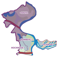
The district has 4,992 inhabitants (as of December 31, 2016) and an area of 21.31 km² . This makes it the largest district in Duisburg in terms of area and the northernmost of the Duisburg districts on the left bank of the Rhine. It borders the cities of Moers and Rheinberg .
Baerl is a rural district. The four larger and some smaller lakes were all created by gravel excavations and are now used as recreational areas. The district includes the districts of Baerl, Binsheim, Gerdt, Lohheide, Lohmannsheide and Uettelsheim.
Binsheim
Binsheim is an agricultural street village in the northeast of Baerl. In the east, separated by the flood protection dike, lies the Rheinaue Binsheim nature reserve. In the north, Binsheim borders the medieval town of Orsoy .
Gerdt
The district of Gerdt is located behind the Rhine dam on the left bank of the Rhine in the north of Homberg . A few dozen houses of the townspeople and isolated farms are surrounded by fields, waste dumps from mining and industrial wastelands, which are developing untouched into new biotopes.
Lohheide
Lohheide is bounded in the west by the Baerler Busch, in the north and northwest by the Lohheider See and in the east by Binsheim. A visit to the Lohmühle, which was built in the north of Lohheide in 1834, is worth seeing. The Lohheider See is popular with water sports enthusiasts.
Lohmannsheide
Lohmannsheide is located directly at the Duisburg-Baerl exit of the A42 motorway , through which the village is divided. The place borders in the east on the Rhine bend of Beeckerwerth , in the north on the center of Baerl and in the south on Gerdt. The Haus-Knipp railway bridge also crosses the Rhine from there . Well-known courtyards are the Lohmannshof, the Kerlenhof and the Scholtheishof. Parts of Lohmannsheide belong to Moers today .
Uettelsheim
Uettelsheim is in the east of the Uettelsheimer See and has only a few houses. In the south and west, the small district is bordered by the Moerser districts of Scherpenberg and Meerbeck as well as by Homberg- Hochheide .
Halen
Only the so-called "Niederhalener Dorfweg", which leads from Baerl down to the banks of the Rhine, refers to the village of Halen , which sank into the Rhine in 1596 . In the Middle Ages, Halen was a neighboring community of Baerl and fought for its existence for hundreds of years due to floods and changes in the course of the Rhine. The Halen village church and Knipp Castle in front of the village have also sunk into the floods.
dialect
In Baerl - as formerly part of the municipality of Rheinkamp - a special variant of " Grafschafter Platt " is spoken. Until after the Second World War, “Platt” was the colloquial language of a broad section of the population - today only a few people speak and understand the traditional dialects. Baerl is located in the Lower Franconian dialect area north of the so-called Benrath line (with the maache-maake distinction), which separates the southern Middle Franconian (also called Ripuarian ) from the northern Lower Franconian . Also located Baerl north of Uerdinger dialect line , which extends from the Rhine coming to sleeve passes by about Kempen to Venlo. This Uerdinger line (also called ek-ech border) delimits the southern Lower Franconian (which is spoken e.g. in Uerdingen and Krefeld) from the northern Lower Franconian , which is in the Krefeld district of Hüls (see Hölsch Plott ) and Kempen, and to the north in the greater Moers area , in the districts of Kleve and Wesel as well as Dinslaken, Duisburg and Mülheim-Ruhr.
One of the most important features of North Lower Franconian is the pronunciation of the personal pronoun "I" as " ek ", while in the south of the Lower Rhine it is pronounced as " ech ". The verb “have” is also spoken differently: in the Baerl space one says z. B. "ek häbb". Further south it says “ech han”. Even if the dialect is on the decline, Platt is cultivated at carnival, on dialect evenings and in clubs. The group of “Baal Kraien!” Is particularly well known in Baerl and the surrounding area.
There is a rich local vernacular literature. The books by
- Georg Kreischer, u. a. : "Op Platt falls down on opgeschrewen" (2001 edition)
- Gottfried Krach, u. a. : "Min Modersprok" (1977 edition, Steiger Verlag)
Quoting from the book by the Baerler author Georg Kreischer (excerpt):
Et Därp on sin Platt
Wor ös os Moddersprook bleewen - had osen Titt sej fottgedrewen
Mar osen Titt, are wej dat not?
Wej häbben sälws et onderlooten - ok like os Äldersch platt de trooten
An os leet dat, dröm proot would be platt ...
coat of arms
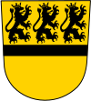
Baerl did not have its own municipal coat of arms. Local associations are therefore partly based on the coat of arms of the Lords of Baerl in their coat of arms . This in turn is based on the coat of arms of the Counts of Moers . The blazon of the coat of arms of the Lords of Baerl reads: On a golden shield, divided by a black crossbar, at the top three soaring left-facing black lions.
In addition, a proposal for a new symbol for Baerl was submitted. It combines elements of the coat of arms of the von Baerl family with the representation of an arch of the Rhine as an indication of the location on the Rhine and an oak leaf with acorn as a reference to the Baerl forest, which gives the place Baerl its name in the form of Barlo or Barle .
traffic
- Rail transport
A railway line runs through Baerl, which today only serves freight traffic between Duisburg-Beeckerwerth and Moers. Formerly there was also a railway line Duisburg-Meiderich Nord-Hohenbudberg with a train station in Baerl. The line had existed since 1912 and led over the Haus-Knipp railway bridge, which was put into operation in the same year . The section between Baerl and Hohenbudberg was shut down on August 25, 1969, and a good year later on October 1, 1970 the section between Duisburg-Meiderich Nord and the Buschmannshof junction followed. All tracks have now been completely dismantled.
- Road traffic
The A 42 motorway has been crossing the Rhine at Baerl with the Beeckerwerther Bridge since 1990 . In 1991 the Duisburg-Baerl junction was put into operation.
- Public transport
Bus traffic in Baerl is regulated by the Duisburg transport company . The lines 909 to Ruhrort -Mühlenweide and the 925 to Obermeiderich / Alstaden end at the Baerl Kirche stop. They connect Baerl with Homberg , Meiderich / Beeck and Duisburg city center. In addition, the NIAG line 913 runs through Baerl and connects it with Rheinberg and Moers - Hülsdonk .
| line | Line route | Tact | operator |
|---|---|---|---|
| 909 / 910 |
Line 909 clockwise and line 910 runs counterclockwise: Obermeiderich Landschaftspark Nord - Mercator-Center - Meiderich Ost Bf - Meiderich Bf - Hamborn Altmarkt - Hamborn Rathaus - Marxloh Pollmann - Röttgersbach - Neumühl - Obermeiderich Landschaftspark Nord |
60 | DVG |
| 913 | Rheinberg School Center - Rheinberg Bf - Rheinberg Town Hall - Budberg - ( Eversael -) Orsoy - Duisburg-Baerl Church - Moers - Meerbeck - Scherpenberg - Moers Bf - Moers Königlicher Hof - Bahnhof Nord - Hülsdonk Nord | 60 to 120 | NIAG |
Web links
- Baerl village
- Baerl-Online
- Street directory Baerl (onlinestreet)
- Entry for Baerl station in the " KuLaDig " database of the Rhineland Regional Association
Individual evidence
- ↑ Population statistics of the city of Duisburg from December 31, 2016 (PDF; 21 kB)
- ^ Federal Statistical Office (ed.): Historical municipality directory for the Federal Republic of Germany. Name, border and key number changes in municipalities, counties and administrative districts from May 27, 1970 to December 31, 1982 . W. Kohlhammer, Stuttgart / Mainz 1983, ISBN 3-17-003263-1 , p. 291 .
- ↑ Binsheimer Höfe ( Memento from July 16, 2012 in the web archive archive.today )
- ↑ Rheinaue Binsheim (PDF) ( page no longer available , search in web archives ) Info: The link was automatically marked as defective. Please check the link according to the instructions and then remove this notice.
- ↑ Lohmühle
- ↑ sailors Community Lohheider Lake
- ↑ See for example the coat of arms of TuS Baerl Tennis .
- ^ Wilhelm Damschen: Rhein-Baerl-Zeitgeschehen in words and pictures , 2017.


