
Federal motorway 42
| Bundesautobahn 42 in Germany | |||||||||||||||||||||||||||||||||||||||||||||||||||||||||||||||||||||||||||||||||||||||||||||||||||||||||||||||||||||||||||||||||||||||||||||||||

|
|||||||||||||||||||||||||||||||||||||||||||||||||||||||||||||||||||||||||||||||||||||||||||||||||||||||||||||||||||||||||||||||||||||||||||||||||
| map | |||||||||||||||||||||||||||||||||||||||||||||||||||||||||||||||||||||||||||||||||||||||||||||||||||||||||||||||||||||||||||||||||||||||||||||||||
 |
|||||||||||||||||||||||||||||||||||||||||||||||||||||||||||||||||||||||||||||||||||||||||||||||||||||||||||||||||||||||||||||||||||||||||||||||||
| Basic data | |||||||||||||||||||||||||||||||||||||||||||||||||||||||||||||||||||||||||||||||||||||||||||||||||||||||||||||||||||||||||||||||||||||||||||||||||
| Operator: |
|
||||||||||||||||||||||||||||||||||||||||||||||||||||||||||||||||||||||||||||||||||||||||||||||||||||||||||||||||||||||||||||||||||||||||||||||||
| Start of the street: |
Kamp-Lintfort ( 51 ° 29 ′ N , 6 ° 35 ′ E ) |
||||||||||||||||||||||||||||||||||||||||||||||||||||||||||||||||||||||||||||||||||||||||||||||||||||||||||||||||||||||||||||||||||||||||||||||||
| End of street: |
Dortmund ( 51 ° 34 ′ N , 7 ° 22 ′ E ) |
||||||||||||||||||||||||||||||||||||||||||||||||||||||||||||||||||||||||||||||||||||||||||||||||||||||||||||||||||||||||||||||||||||||||||||||||
| Overall length: | 58 km | ||||||||||||||||||||||||||||||||||||||||||||||||||||||||||||||||||||||||||||||||||||||||||||||||||||||||||||||||||||||||||||||||||||||||||||||||
|
State : |
|||||||||||||||||||||||||||||||||||||||||||||||||||||||||||||||||||||||||||||||||||||||||||||||||||||||||||||||||||||||||||||||||||||||||||||||||
| Development condition: | 2 × 2 and 2 × 3 lanes | ||||||||||||||||||||||||||||||||||||||||||||||||||||||||||||||||||||||||||||||||||||||||||||||||||||||||||||||||||||||||||||||||||||||||||||||||
_02_ies.jpg) |
|||||||||||||||||||||||||||||||||||||||||||||||||||||||||||||||||||||||||||||||||||||||||||||||||||||||||||||||||||||||||||||||||||||||||||||||||
| A 42 in Oberhausen | |||||||||||||||||||||||||||||||||||||||||||||||||||||||||||||||||||||||||||||||||||||||||||||||||||||||||||||||||||||||||||||||||||||||||||||||||
|
Course of the road
|
|||||||||||||||||||||||||||||||||||||||||||||||||||||||||||||||||||||||||||||||||||||||||||||||||||||||||||||||||||||||||||||||||||||||||||||||||
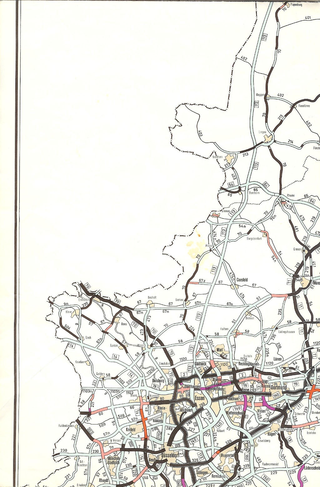
The federal motorway 42 (abbreviation: BAB 42 ) - short form: Autobahn 42 (abbreviation: A 42 ) - runs from west to east in the northern Ruhr area from Kamp-Lintfort via the north of Duisburg , Oberhausen , Bottrop , the north of Essen , Gelsenkirchen , Herne and Castrop-Rauxel to Dortmund . It is also called the Emscherschnellweg .
history
Construction began in the Herne area in 1965, the route was released as a state road in 1968 and only upgraded to a motorway in 1969. In 1971 the first section between the Essen-Nord junction and the Herne junction was fully released and in 1975 the section from the Herne junction to the Castrop-Rauxel-Ost junction with a connection to the A 45 was released . In 1978 only the Dortmund-Bodelschwingh junction was built. In the west, construction was carried out beyond Essen to the Oberhausen-West junction (with a connection to the A3 ). In the 1980s, it was extended to the A 59 ( Duisburg-Nord motorway junction ) and, in the last section, to Kamp-Lintfort with the construction of a bridge over the Rhine . This linked the A 42 with the A 57 on the left bank of the Rhine . Between the Herne-Börnig and Herne-Baukau driveways, a canal bed that had already been closed before the Second World War (former branch canal of the Dortmund-Ems canal) was used for routing. Coming from Herne-Baukau in the direction of Castrop-Rauxel, the course of the former waterway can still be seen from the straight road layout.
Open to traffic
The handover of traffic for the individual sections took place as follows:
| section | Release (year) | Length (km) |
|---|---|---|
| AS Herne-Crange -AS Herne Baukau | 1968 | 2.8 km |
| AS Essen-Nord - AS Gelsenkirchen-Heßler | 1970 | 3.7 km |
| AS Gelsenkirchen-Heßler - AS Herne-Crange | 1971 | 10 km |
| Border of the regional associations west of AS Bottrop-Süd - AS Essen Nord | 1971 | 5 km |
| J Oberhausen-Neue Mitte - border of regional associations west of J Bottrop Süd | 1974 | 2.8 km |
| AS Herne-Baukau - AK Castrop-Rauxel Ost | 1975 | 10.6 km |
| AS Duisburg-Nord - AK Oberhausen West | 1975 | 3.3 km |
| AK Oberhausen West - AS Oberhausen-Neue Mitte | 1975 | 5.6 km |
| AK Castrop-Rauxel-Ost - AS Dortmund-Bodelschwingh | 1978 | 0.3 km |
| AS Duisburg-Beeck - AK Duisburg Nord | 1980 | 2.7 km |
| east of Duisburg-Beeckerwerth - AS Duisburg-Beeck | 1985 | 1.3 km |
| AK Kamp-Lintfort - AS Moers-Nord | 1991 | 4.0 km |
| AS Duisburg-Baerl - east of Duisburg-Beeckerwerth | 1991 | 3.0 km |
| AS Moers Nord - AS Duisburg Baerl | 1992 | 3.0 km |
State of development
The motorway has four lanes from the Castrop-Rauxel Ost junction to the Bottrop-Süd junction. The western part has six lanes throughout.

Renaming of connection points
Until April 4, 2006, junction 16 was called Gelsenkirchen-Schalke . Since the new junction 17 with the same name (according to earlier plans, this should initially be called Gelsenkirchen-Schalke-Nord ) was opened on that day, junction 16 was renamed Gelsenkirchen-Zentrum at the same time .
Further renamed connection points are:
- Bottrop-Süd, originally Bottrop / Essen- Borbeck
- Oberhausen-Neue Mitte, originally Oberhausen-Osterfeld
Earlier planning
Eastern extension
In the plan for the expansion of the federal trunk roads from 1971 to 1985, an extension to the northeast of Unna was planned at the eastern end of today's A 42 (junction Dortmund-Bodelschwingh), where the then internally designated A 78 motorway into the north-south New line of the B 233n (later: A 443 ) Bönen - Unna - Iserlohn should flow. The motorway was south of Mengede , north of Nice , Lindenhorst and Eving , south of Derne , north of Scharnhorst, between Kurl and Kaiserau run south of the AS Kamen-South the A1 crossing and south of Heeren-Werve be performed and the A 443 at about the level of the Dortmund - Welver / Kreisstraße 36 ( Lünern - Heeren-Werve) railway line . With effect from January 1, 1975, the section also became part of the new A 42 route. The A 42 route was therefore only about 1 to 2 km parallel to the south of the A 2. At the Bodelschwingh junction, extensive preliminary construction work was already carried out during the construction of the A 42, there are two lanes with two lanes each under the A 45. These lanes were in the last 20 years partly used as storage space. The extension to the east is not included in the 2003 Federal Transport Infrastructure Plan.
Western extension
The plan for the expansion of the federal highways in the years 1971 to 1985 provided that the then planned under the internal designation "A 78" should be continued as the four-lane B 1103 from the Kamp-Lintfort junction to Rheurdt . It was also intended to finally connect a two-lane B 1103n to this route via the area north of Kerken and Straelen to the Germany / Netherlands border .
From 1975 the planning for the motorway, now dedicated as the A 42, provided for a route as far as the Rheurdt area, where it would meet the A 40 planned along the B 510 . A few kilometers southwest of the A 40 / A 42 motorway triangle, the motorway should end on the route of the B 510.
The Federal Transport Infrastructure Plan 2003 includes a two-lane bypass south of Kamp-Lintfort on the B 528 with a total of 6.3 kilometers in the priority area. The first section was opened to traffic in December 2006 and leads to Friedrich-Heinrich-Allee in the south of Kamp-Lintfort.
Other originally planned links between the A 42 and the motorway network
Other planned north-south motorways should cross the A 42:
The southern extension of the A 31 should cross the A 42 between the junctions Oberhausen-Neue Mitte and Bottrop Süd in the area of Vondern Castle , here the gradient of the A 42 is noticeably lowered.
The Essen-Nord junction (formerly Essen-Nord junction) is part of the Essen-Ost– Gladbeck section of the A 52 .
In the area of the current Gelsenkirchen-Schalke junction, a link with the A 41 , the Gelsenkirchen north-south motorway, was planned. Construction work (bridges on the secondary roads) can still be seen today.
Project "Park Autobahn A 42"
In the course of the successful application of Essen and the Ruhr area as European Capital of Culture , work began in 2010 to improve the area around the A 42. The project is entitled "A 42 Park Motorway". The wood on the sides of the autobahns was cleared to allow a view of the industrial landscape of the Ruhr area. Periodically were Urweltmammutbäume ( Metasequoia glyptostroboides ) planted as Leitbäume, the selection took place on the Internet by a public election. In addition, the five motorway junctions are to be gradually given specially designed ear parks on their inner surfaces. At the junction with the A 45 near Castrop-Rauxel, the park has already been completed. In addition, sculptural works are set up at the junction, which are called "park gates", bear the number of the exit and are intended to point out the particularities of the respective city or district. After all, "parking filling stations" at 5 junction points are intended to provide motorists with information about the Emscher Landscape Park and make it easier to switch to public transport through P + R spaces. It was continued in 2011, evaluated by the Technical University of Dortmund and is to be fully implemented over the next 20 years.

Web links
Individual evidence
- ↑ Construction work on federal trunk roads in 1972. Expansion of federal trunk roads from 1971 to 1985. Annex to the road construction report 1972. Federal Minister of Transport, Road Construction Department, accessed on March 31, 2013 (map excerpt).
- ^ The large Shell Atlas, Mairs Geographischer Verlag, new edition, Stuttgart 1977/78, p. 32
- ↑ Network of federal motorways and federal highways. Status January 1, 1976. Federal Minister of Transport, Road Construction Department, accessed on March 31, 2013 (map excerpt).
- ↑ Construction work on federal trunk roads in 1972. Expansion of federal trunk roads from 1971 to 1985. Annex to the road construction report 1972. Federal Minister of Transport, Road Construction Department, accessed on March 31, 2013 (map excerpt).
- ↑ Network of federal motorways and federal highways. Status January 1, 1976. Federal Minister of Transport, Road Construction Department, accessed on March 31, 2013 (map excerpt).
- ↑ Network of federal motorways and federal highways. Status January 1, 1976. Federal Minister of Transport, Road Construction Department, accessed on March 31, 2013 (map excerpt).
- ↑ The West: Autobahn 42 is to become a boulevard
- ↑ Election campaign for the guide tree on strassen.nrw.de ( Memento from September 6, 2009 in the Internet Archive )
- ↑ Parkautobahn on strassen.nrw.de ( Memento from February 9, 2011 in the Internet Archive )
- ↑ A 42 parking autobahn. Parking stations. RUHR.2010 GmbH ( Memento from April 8, 2012 in the Internet Archive )
- ↑ A 42 parking autobahn. RUHR.2010 GmbH ( Memento from April 8, 2012 in the Internet Archive )
- ↑ A 42 park autobahn. The idea. Free space for a panoramic road of industrial culture. RUHR.2010 GmbH ( Memento from October 18, 2013 in the Internet Archive )
