Motorway junction Oberhausen-West
| Motorway junction Oberhausen-West | |
|---|---|
|
|
|
| map | |
| location | |
| Country: | Germany |
| State : | North Rhine-Westphalia |
| Coordinates: | 51 ° 29 '15 " N , 6 ° 48' 53" E |
| Height: | 25 m above sea level NN |
| Basic data | |
| Design type: |
Shamrock with internal semi-direct ramps |
| Bridges: | 4 (motorway) / 2 (other) |
| Construction year: | 1975 |
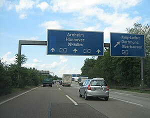
| The A3 just before the Oberhausen-West interchange | |
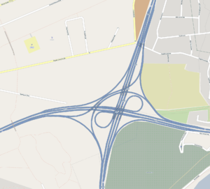
The motorway junction Oberhausen-West (abbreviation: AK Oberhausen-West ; short form: Kreuz Oberhausen-West ) is a motorway junction in North Rhine-Westphalia in the Rhine-Ruhr metropolitan region . It connects the federal highway 3 ( Oberhausen - Frankfurt am Main - Passau ) with the federal highway 42 ( Emscherschnellweg ).
geography
The motorway junction is almost entirely in the urban area of Duisburg , only the eastern driveways are partially in the area of Oberhausen . The closest districts are Neumühl and Meiderich , belonging to Duisburg, and Lirich and Buschhausen on the Oberhausen side. It is located around 7 km northeast of Duisburg city center, around 5 km west of Oberhausen city center and around 15 km northwest of Essen .
To the southeast of the cross are the Oberhausen West Cemetery and the Rhine-Herne Canal .
The Oberhausen-West motorway junction has junction number 12 on the A 3 and number 8 on the A 42.
history
It was opened to traffic in the 1980s with the completion of the A 42 and was called Kreuz Duisburg / Oberhausen until 1992.
Design and state of development
The narrow topographical conditions required a special construction method for the motorway junction. The best-known form of a motorway junction, the clover leaf, consists of four direct and four indirect connecting ramps . In the case of the Oberhausen-West motorway junction , this classic cloverleaf construction had to be dispensed with in the southeast, where the Oberhausen Westfriedhof borders the cross, and in the northwest, where a residential area in the Schmidthorst district of Duisburg is located. In the south-eastern quadrant, the ear was left out and a direct connecting ramp was built with a comparatively narrow radius. In the north-west, the indirect connecting ramp was also dispensed with. The two missing ears were replaced by two semi-direct ramps that meet in the north-western quadrant within the direct ramp. The construction manages with three short throws , uses the areas between the ramps, but often branches out at short intervals.
From a technical point of view, the cross consists of two motorway forks, the bridges of which are shared and the remaining ramps are indirect. This design is unique in Germany, is used sporadically around the world and offers interlaced traffic flow, making the node more efficient than a clover leaf. If the intersecting motorways do not run at right angles in the catchment area, this form is better suited to meet the demand.
Both motorways have six lanes. All connecting ramps are single-track; those that run directly parallel are equipped with anti-glare fences , as there is oncoming traffic to the right of the separate lane.
Road crossings similar in principle
- Autobahn triangle Nahetal near Bingen , further construction of the A 60 was planned, only the junction from the A 61 to Rüsselsheim was realized
- AS Miquelallee in downtown Frankfurt , A 66
- Motorway intersection Munich-North , transition of the A 9 into the Munich motorway ring ( A 99 )
Road crossings of the same principle
- Motorway junction Graz-West between the Austrian motorways A 2 ( Süd Autobahn ) and A 9 ( Pyhrn Autobahn )
particularities
Together with the A 42, the cross forms a relief section for the A 2 in the Ruhr area . Before the construction, there were very frequent traffic jams, especially in rush hour traffic. After completion, the A 2 could be relieved of most of the inland traffic in the Ruhr area by the A 42.
Traffic volume
The cross is used by around 217,000 vehicles every day.
| From | To | Average daily traffic volume |
Share of heavy goods traffic |
||||
|---|---|---|---|---|---|---|---|
| 2005 | 2010 | 2015 | 2005 | 2010 | 2015 | ||
| AS Oberhausen-Holten (A 3) | AK Oberhausen-West | 106,000 | 122,700 | no data | no data | 15.6% | no data |
| AK Oberhausen-West | AS Oberhausen-Lirich (A 3) | 117,700 | 127,600 | 137,100 | 13.5% | 14.3% | 13.2% |
| AS Duisburg-Neumühl (A 42) | AK Oberhausen-West | 85,900 | 79,000 | 86,600 | 13.1% | 10.1% | 11.3% |
| AK Oberhausen-West | AS Oberhausen-Buschhausen (A 42) | 81,300 | 85,100 | 88,500 | 11.0% | 10.6% | 14.0% |
Web links
Individual evidence
- ↑ Manual road traffic census 2005. (PDF) Results on federal motorways. BASt Statistics, 2005, accessed on July 6, 2020 .
- ↑ Manual road traffic census 2010. (PDF) Results on federal motorways. BASt Statistics, 2010, accessed on July 6, 2020 .
- ↑ Manual road traffic census 2015. (PDF) Results on federal motorways. BASt Statistics, 2015, accessed on August 27, 2017 .


