Nuremberg motorway junction
| Nuremberg motorway junction | |
|---|---|
|
|
|
| map | |
| location | |
| Country: | Germany |
| State : | Bavaria |
| Coordinates: | 49 ° 27 '31 " N , 11 ° 14' 38" E |
| Height: | 345 m above sea level NN |
| Basic data | |
| Design type: | Shamrock with tangents |
| Bridges: | 3 (motorway) / 3 (other) |
| Construction year: | 1941 |
| The A3 from the direction of Würzburg (right lane) before the Nürnberg junction | |
The Nuremberg motorway junction (abbreviation: AK Nürnberg ; short form: Nuremberg cross ) is a motorway junction in Bavaria , which is located in the Nuremberg metropolitan region . It connects the federal highway 3 ( Oberhausen - Frankfurt am Main - Passau ) with the federal highway 9 ( Berlin - Leipzig - Munich ).
geography
The cross lies on the border of the parish-free area of Brunn with the Haimendorfer Forest in the district of Nürnberger Land . The surrounding cities and communities are Leinburg , Nuremberg , Röthenbach and Lauf an der Pegnitz . The cross is located about 10 km east of downtown Nuremberg and about 60 km south of Bayreuth .
It is an important traffic junction because the important connections Netherlands - Austria / Linz (A 3) and Berlin / Poland - Munich - Austria / Innsbruck (A 9) meet here.
The Nuremberg motorway junction has junction number 88 on the A3 and 51 on the A9.
Design
The junction Nuremberg is a cloverleaf with TOTSO : the main lane of the A 3 from Würzburg supplied as A 9 in the direction of Munich , so that for further travel on the A 3 in the direction of Regensburg , the track must be changed. Likewise, the main carriageway of the A 9 from Munich continues as the A 3 to Frankfurt am Main .
history
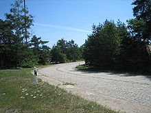
The Nürnberg Kreuz was originally built as an autobahn clover leaf. After the Second World War, due to the division of Germany, there was little traffic on the A 9 north of Nuremberg. Since the traffic in the direction of Würzburg was significantly stronger, the motorway junction was extended by a tangent. The fourth quadrant of the clover leaf, originally built for the change in this direction, still exists. Until the beginning of 2018 it was still paved with the original cobblestones and may only be used by the motorway maintenance authority.
Traffic volume
The cross is used by around 167,000 vehicles every day, making it one of the busiest in Bavaria.
| From | To | Average daily traffic volume |
Share of heavy goods traffic |
||||
|---|---|---|---|---|---|---|---|
| 2005 | 2010 | 2015 | 2005 | 2010 | 2015 | ||
| AS Nürnberg-Mögeldorf (A 3) | AK Nuremberg | 99,000 | 96,900 | 100,900 | 15.0% | 16.1% | 16.0% |
| AK Nuremberg | AK Altdorf (A 3) | 40,000 | 40,000 | 43,600 | 18.8% | 19.7% | 20.7% |
| AS run (A 9) | AK Nuremberg | 70,900 | 74,300 | 79,300 | 14.2% | 14.8% | 15.5% |
| AK Nuremberg | AS Nürnberg-Fischbach (A 9) | 103,000 | 103,600 | 109,700 | no data | 15.8% | 15.7% |
Web links
Individual evidence
- ↑ Manual road traffic census 2005. (PDF) Results on federal motorways. BASt Statistics, 2005, accessed on July 7, 2020 .
- ↑ Manual road traffic census 2010. (PDF) Results on federal motorways. BASt Statistics, 2010, accessed on July 7, 2020 .
- ↑ Manual road traffic census 2015. (PDF) Results on federal motorways. BASt Statistics, 2015, accessed on August 22, 2017 .


