Castrop-Rauxel-Ost motorway junction
| Castrop-Rauxel-Ost motorway junction | |
|---|---|
|
|
|
| map | |
| location | |
| Country: | Germany |
| State : | North Rhine-Westphalia |
| Coordinates: | 51 ° 33 '41 " N , 7 ° 21' 29" E |
| Height: | 73 m above sea level NN |
| Basic data | |
| Design type: | Shamrock |
| Bridges: | 1 (motorway) / 4 (other) |
| Castrop-Rauxel motorway junction | |
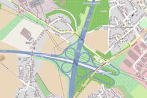
The Castrop-Rauxel-Ost motorway junction (abbreviation: AK Castrop-Rauxel-Ost ; short form: Castrop-Rauxel-Ost junction ) is a motorway junction in North Rhine-Westphalia in the Rhine-Ruhr metropolitan region . It connects the federal autobahn 42 ( Emscherschnellweg ) with the federal autobahn 45 ( Sauerland line ; E 41 ).
geography
The motorway junction is located in the urban area of Dortmund in the urban district Mengede , on the city limits to the eponymous Castrop-Rauxel . The closest districts are Deininghausen and Dingen , belonging to Castrop-Rauxel, as well as Brüninghausen , Bodelschwingh and Oestrich in Dortmund. It is located about 10 km northwest of Dortmund city center, about 50 km south of Münster and about 25 km northeast of Essen .
The Gustav Knepper power station was located northwest of the motorway junction .
The Castrop-Rauxel-Ost motorway junction has junction number 27 on the A 42 and number 3 on the A 45.
Design and state of development
Both motorways have four lanes. All connecting ramps are single-track. The A 42 only uses the distribution lanes at the intersection.
The motorway junction was laid out as a clover leaf , as the original planning provided for an extension of the A 42 to the A 1. On the A 42, the junction forms a double junction with the Dortmund-Bodelschwingh AS .
Traffic volume
The cross is used by around 100,000 vehicles every day.
| From | To | Average daily traffic volume |
Share of heavy goods traffic |
|---|---|---|---|
| AS Castrop-Rauxel (A 42) | AK Castrop-Rauxel-Ost | 47,400 | 12.2% |
| AK Castrop-Rauxel-Ost | AS Dortmund-Bodelschwingh (A 42) | no data | no data |
| AK Dortmund-Northwest (A 45) | AK Castrop-Rauxel-Ost | 55,000 | 11.0% |
| AK Castrop-Rauxel-Ost | AS Dortmund-Hafen (A 45) | 70,400 | 9.2% |
Trivia
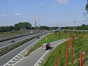
As a project of the Capital of Culture 2010 , the A 42 was redesigned into a park highway . For this purpose, the Castrop-Rauxel-Ost cross was horticultural transformed into the Castrop-Rauxel ear park.
Web links
Individual evidence
- ^ AK Castrop-Rauxel-Ost. (No longer available online.) Autobahn intersections & Autobahn triangles in Germany, 2011, formerly in the original ; Retrieved August 18, 2013 . ( Page no longer available , search in web archives ) Info: The link was automatically marked as defective. Please check the link according to the instructions and then remove this notice.
- ↑ Manual traffic census BAB 2015. (PDF) BASt Statistics, 2015, accessed on September 14, 2017 .

