Kamp-Lintfort motorway junction
| Kamp-Lintfort motorway junction | |
|---|---|
|
|
|
| map | |
| location | |
| Country: | Germany |
| State : | North Rhine-Westphalia |
| Coordinates: | 51 ° 29 '20 " N , 6 ° 34' 35" E |
| Height: | 18 m above sea level NN |
| Basic data | |
| Design type: | Shamrock with semi-direct ramp |
| Bridges: | 2 (motorway) / 2 (other) |
| Last modification: | 2006 |
| The Pattberg dump with the Kamp-Lintfort junction below it |
|
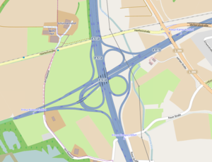
The Kamp-Lintfort motorway junction (abbreviation: AK Kamp-Lintfort ; short form: Kamp-Lintfort junction ) is a motorway junction in North Rhine-Westphalia in the Rhine-Ruhr metropolitan region . It connects the federal highway 42 ( Emscherschnellweg ) with the federal highway 57 ( Trans-Niederrhein-Magistrale ; E 31 ).
geography
The motorway junction is located in the urban area of Moers in the Wesel district , on the city limits to the eponymous Kamp-Lintfort . The closest districts are Genend, Repelen and Kohlenhuck, all in the Moers area. It is located about 35 km northwest of Düsseldorf , about 15 km northwest of Duisburg and about 35 km northeast of Venlo .
The piles Pattberg and Northern Germany , which can be seen from afar , are located directly northeast and southwest of the motorway junction.
The Kamp-Lintfort motorway junction has junction number 1 on the A 42 and number 8 on the A 57.
Design and state of development
Both motorways have four lanes, the B 528 has three lanes. All connecting ramps are single-track.
The motorway junction was originally designed as a left-hand trumpet . After the B 528 was connected to the motorway junction in 2006, it was converted into a cloverleaf with a semi-direct ramp, as this design did not require the dismantling of the left-hand trumpet. On the A 57, the junction forms a double junction with the Kamp-Lintfort AS .
Traffic volume
In 2015 the cross was used by around 110,000 vehicles every day.
| From | To | Average daily traffic volume |
Share of heavy goods traffic |
||||
|---|---|---|---|---|---|---|---|
| 2005 | 2010 | 2015 | 2005 | 2010 | 2015 | ||
| AK Kamp-Lintfort | AS Moers-Nord (A 42) | 46,500 | 40,900 | 49,100 | 16.5% | 15.1% | 17.7% |
| AS Kamp-Lintfort (A 57) | AK Kamp-Lintfort | 55,600 | 58,900 | 61,200 | 11.1% | 12.1% | 9.8% |
| AK Kamp-Lintfort | AS Moers-Hülsdonk (A 57) | 63,000 | 62,700 | 63,700 | 16.1% | 12.5% | 15.3% |
| Kamp-Lintfort (B 528) | AK Kamp-Lintfort | no data | |||||
Individual evidence
- ↑ Manual road traffic census 2005. (PDF) Results on federal motorways. BASt Statistics, 2005, accessed on October 26, 2017 .
- ↑ Manual road traffic census 2010. (PDF) Results on federal motorways. BASt Statistics, 2010, accessed on October 26, 2017 .
- ↑ Manual road traffic census 2015. (PDF) Results on federal motorways. BASt Statistics, 2015, accessed on October 26, 2017 .

