
Kamp-Lintfort
| coat of arms | Germany map | |
|---|---|---|

|
Coordinates: 51 ° 30 ' N , 6 ° 32' E |
|
| Basic data | ||
| State : | North Rhine-Westphalia | |
| Administrative region : | Dusseldorf | |
| Circle : | Wesel | |
| Height : | 33 m above sea level NHN | |
| Area : | 63.14 km 2 | |
| Residents: | 37,596 (Dec. 31, 2019) | |
| Population density : | 595 inhabitants per km 2 | |
| Postal code : | 47475 | |
| Area code : | 02842 | |
| License plate : | WES, DIN, MO | |
| Community key : | 05 1 70 020 | |
| LOCODE : | DE KLF | |
City administration address : |
Am Rathaus 2 47475 Kamp-Lintfort |
|
| Website : | ||
| Mayor : | Christoph Landscheidt ( SPD ) | |
| Location of the city of Kamp-Lintfort in the Wesel district | ||
  |
||

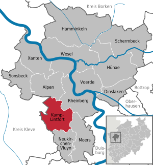
Kamp-Lintfort is a city on the lower Lower Rhine at the westernmost edge of the Ruhr region in the northwest of the country North Rhine-Westphalia and is a middle district town of Wesel in the administrative district of Dusseldorf . The Wesel district represents the city of Kamp-Lintfort at the Ruhr Regional Association and the Rhineland Regional Association . In 2020 , the city will be the venue for the North Rhine-Westphalia State Horticultural Show .
geography
Spatial location
Kamp-Lintfort is located in the Lower Rhine Plain , six kilometers southwest of Rheinberg and eight kilometers northwest of Moers . According to the landscape definition of the agglomeration of the Ruhr area, the inner city area is assigned to the agglomeration , but the less populated, surrounding area of the city is not. A large part of the urban area is filled by the "Leucht" forest area, which is part of the Xanten state forest .
City structure

The closed urban development is mostly in the districts of Lintfort, Stadtkern, Geisbruch and Gestfeld. Plant colonies of the former Friedrich Heinrich colliery and a formerly operated brickworks shape large parts of the cityscape. In the center, the “Three White Giants” formed the skyline of Kamp-Lintfort; With 95 percent vacancy, this urban planning project of the late 1960s had turned into a nightmare. A conversion as a shopping center was planned for the area. After funding from the state of North Rhine-Westphalia had been approved, two of the three high-rise buildings were demolished in 2009, the third and largest was blown up on December 19, 2010, which finally freed the space for the redesign of this urban area. The “EK3” shopping center was built on the site in 2012 after an 18-month construction period. The skyline of Kamp-Lintfort is also determined by the buildings in the new city center built between 1975 and 1985.
In contrast to this, the district of Kamp with the historical settlement from the heyday of the monastery forms the historical center of the city.
In the 1950s, additional housing developments were carried out on the outskirts of the Lintfort district at Tor Ost and in the Geisbruch and Gestfeld districts. These parts of the city were later added to by building their own homes. The Niersenbruch district is characterized by predominantly individual buildings.
The outlying districts have retained their rural character. Particularly noteworthy is the street village of Hoerstgen .

The city of Kamp-Lintfort is divided into ten districts:
The districts of Lintfort, Gestfeld and Geisbruch are located in the area of the former municipality of Lintfort while Dachsbruch and Kamp are in the area of the former municipality of Kamp. The city center and Niersenbruch districts are located in the area of the former Kamperbruch municipality . The area of Rossenray, Hoerstgen and Saalhoff largely corresponds to that of the old communities of the same name.
Neighboring municipalities / cities
|
Issum community ( Kleve district ) |
Municipality of the Alps | City of Rheinberg |
.svg)
|
||
|
Rheurdt community ( Kleve district ) |
City of Neukirchen-Vluyn | City of Moers |
history
The name Kamp comes from the Latin campus and means "field". The name goes back to the Middle Ages, when the area of the city consisted mainly of swampy landscape. That was also one of the reasons why the Cistercians did not, as usual, build their seat in the country, but moved it to an elevation, the Kamper Berg (height: 45 m ). The name Lintfort comes from the old Franconian language, which means something like "edge of the moor".
The earliest traces of human settlement date from the Neolithic Age, around 3000 to 1800 BC. The earliest written mention of the place comes from the year 856: ter eke in boicholt . On January 31, 1123 (at that time the Easter style was still used, therefore there are also writings that specify the year 1122), the first Cistercian monastery was founded on German soil with the support of Archbishop Friedrich I of Cologne . Starting from the Kamp monastery , around 100 other Cistercian branches were founded, which extended into the Baltic States . After the Truchsessian War (1583 to 1588) the last abbot left the monastery and it was not until 1640 that the first Cistercians came back and rebuilt the monastery.

After the beginning of the Thirty Years War (1620), the Spaniards began building the Fossa Eugeniana , which was to connect the Rhine with the Meuse . This canal ran right past the monastery. In the area of Kamp-Lintfort several jumps were built to protect against the Dutch .
Between 1695 and 1705, the abbots Holtmann, Richterich and Norf built today's baroque buildings of the monastery church and the hospital (now the parish office). Furthermore, extensive convent buildings were erected on the south side of the monastery church. From 1742 to 1747, under Abbot Daniels, the magnificent terrace gardens were built on the southern slope of the Kamper Berg as well as a castle-like prelature building on the west side of the monastery church. The monastery was given the legal title of a prelature with its own jurisdiction. For this purpose, a courthouse was built on the Kamper Berg, which is now a memorial. After the French occupation, the monastery was secularized in 1802 and the monks were expelled; only one remained to continue the pastoral care of the place. The extensive monastery buildings were demolished with the exception of the church and the hospital as a rectory. The terrace garden was left to its own devices and overgrown.
The current district of Hoerstgen formed the rulership of the same name, which was a fiefdom of the County of Moers. It was inherited from the von Drachenfels to the Mirlar zu Millendonk and in 1754 to the Barons of Knesebeck . The imperial immediacy was contested by the neighbors Moers and Kurköln.
After the Congress of Vienna in 1815, a large part of the left Lower Rhine fell to Prussia . The mayor's offices of Camp and Vierquartier in the urban area were assigned to the district of Moers .

On May 1st, 1907, the groundbreaking ceremony took place at the Friedrich Heinrich colliery , which started mining on July 1st, 1912. As a result of the construction of the colliery's settlements and the Pauen brickworks in Kamperbruch, which came into operation at the same time, a coherent settlement area was formed on open space. In the years 1928 to 1930, the Christ Church was built as the main church of the Lintfort Evangelical Church. This community had maintained an emergency church in the colliery settlement since 1914. In addition, the St. Joseph branch was set up in Lintfort, which was also initially housed in an emergency church. From 1931 to 1934, a splendid church was built for the parish of St. Josef as the parish church of Lintfort.

April 1, 1934, the offices were four quarters (consisting of the rural communities Kamperbruch for new rural community "Camp-Lintfort," Lintfort, Rossenray and Saalhoff) Camp and Hoerstgen combined . Shortly afterwards the spelling was changed to "Kamp-Lintfort".
Bombardments during World War II caused destruction, especially in parts of the old settlement near the mine. During the Allied advance in the spring of 1945, the area around Kamp Monastery was more severely affected.
On March 25, 1945, the commanders of the Allied troops met in the New Casino of the Friedrich Heinrich colliery: the American General and later President Dwight D. Eisenhower , Prime Minister Winston Churchill and Field Marshal Bernard Montgomery . On February 12, 1950, the municipality of Kamp-Lintfort was granted city rights. For this purpose, the certificate issued on January 7th for the granting of city rights was handed over to Mayor Robert Schmelzing. In 1954 the order of the (shod) Carmelites moved into the monastery with nine religious. In 1957 the new winding tower of Shaft 1 was inaugurated on the Friedrich Heinrich colliery and over time it became one of the city's landmarks.
The field handball team of TuS Lintfort became German champions for the first time in 1959 with a 10: 9 over Bayer 04 Leverkusen , and in 1961 the title was won again against TSV Ansbach.
From 1963 coal was mined at the Rossenray mine. In 1970, with the construction of the large Rossenray 1 winding tower, the landscape was given another landmark that was visible from afar. The demolition of the headframe began in mid-October 2019.
With the district reform , which came into force on January 1, 1975, the district of Moers was dissolved, and the town was slightly enlarged to become the district of Wesel . The planned incorporation into Duisburg could be prevented. In the 1970s and 1980s, a completely redesigned city center with a new town hall was built on the fallow site of the Pauen brickworks and adjacent open spaces. Since then, these have formed the municipal center of the city. In 1988, the restoration of the fallow terrace gardens of the Kamp monastery began. This was reopened on October 1, 1990 with a festive event.
The Bishop of Münster , Reinhard Lettmann , planned a cultural and spiritual center on the Kamper Berg with the Order of the Carmelites in 2002, since the Carmelites dissolved the convent and only one member of the order remained as a priest in the former monastery. In 2003 the Siemens branch in Kamp-Lintfort celebrated its 40th anniversary. After a sale in 2005 to the Taiwanese company BenQ , the company filed for bankruptcy in 2006 and over 2000 people became unemployed. On November 28, 2004, all of the city's Catholic parishes merged to form the parish of St. Josef.
Population development

Population of the city of Kamp-Lintfort. The figures are either estimates, census results (¹) or official updates from the respective statistical offices (main residences only). The current information in the table relates to the data from the city of Kamp-Lintfort.
|
|
Up until the early 20th century there were hardly any inhabitants in what is now the city. Except for the districts of Kamp and Hoerstgen, the other areas were very sparsely populated. In 1910 the population was around 3,000, and by 1939 it had risen to around 23,300, a result of mining that drew many people to the Rhine and Ruhr. Most of them came from the German East or Poland. After the Second World War, several new settlement areas were created and by 1960 the population had grown to 35,000. By 1995, the population only grew very slowly to around 41,000 and has since declined slightly, among other things as a result of the decline in coal mining and the economic structural change in the region.
Dialect and colloquial language
Kamp-Lintfort with its scattered districts and settlements is located in a Kleverland dialect north of the Uerdinger line , which stretches from the Rhine via Kempen to Venlo. This dialect line (also called “ik-ich-Grenz”) separates the southern Lower Franconian (which is spoken in Uerdingen and Krefeld, for example, with the pronunciation of “esch” for the personal pronoun “I”) from the northern Lower Franconian Platt, which im Krefeld district Hüls (see Hölsch Plott ) begins and is spoken (or was) in different variants throughout the northern Lower Rhine, including in the Kamp-Lintfort area - with the pronunciation of "ek" instead of "I" ("ek bön enen Kamp'sche ”).
However, the dialect is rapidly disappearing and is hardly understood by the younger generation. Instead, a “new” colloquial language prevails, so-called “Niederrhein-Deutsch” or Ruhrdeutsch , called “Regiolekt” by linguists. Although it is based on Standard German, it has special characteristics due to the inclusion of expressions from immigrants or buzzwords from the youth language. The miner's language has also left its mark on the Kamp-Lintfort colloquial language. Many are familiar with the saying: "But hate it!" The term feed sack indicates that something “went wrong”. It comes from the time when pit horses were still working underground, which were immobilized with the feed sack in difficult conditions .
politics
City Councilor and Mayor
According to the results of the 2014 local elections, the 44 seats in the city council are distributed among the individual parties as follows:
| Political party | Seats |
|---|---|
| Social Democratic Party of Germany | 24 |
| Christian Democratic Union | 11 |
| Alliance 90 / The Greens | 4th |
| The left | 2 |
| Free Democratic Party | 1 |
| Free citizen community | 1 |
| Free voters | 1 |
Mayor of Kamp-Lintfort is Christoph Landscheidt ( SPD ).
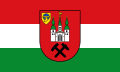
Coat of arms, flag, banner, seal and logo
The former municipality (now the city) was granted the right to carry a coat of arms, a flag (banner) and a seal with a certificate from the Minister of the Interior of North Rhine-Westphalia dated December 9, 1949. The city also has a logo.

coat of arms

banner
flag

seal

logo


The city's coat of arms depicts the historical and formative elements of the city: the Cistercian coat of arms with globe and ploughshare in the top left, an abstract image of the monastery in the middle and, underneath, mallets and iron for the coal mine, the city's largest employer. It is emblazoned as follows : “In a red field the silver Kamp Abbey Church with a green roof and spiers; the two side towers bear a golden ball at the top, the roof turret a golden rooster. A black mallet and a black iron crossed under the church. In the upper right corner a golden label, inside a blue globe, which is enclosed by a golden ring from which a golden ploughshare extends downwards. "
Flag and banner
Description of the flag: "The flag shows the colors red / white / green in the transverse direction and the coat of arms in the middle."
Description of the banner: "The banner shows the colors red / white / green in the longitudinal direction and the coat of arms a little above the middle."
seal
The city of Kamp-Lintfort has an official seal that is similar in shape and size to the seal printed in the main statute. “Left inscription: 'STADT KAMP' - right inscription: '-LINTFORT' - seal image: On a black circular field that is followed by two more smaller circles at the top and bottom, the symbols of the coat of arms, a three-tower church with roof and spire; to the right of the church is a small label with a sphere encircled by a ring from which a ploughshare hangs; mallet and hammer crossed at the bottom. "
logo
The city has had a new logo since 2013, which emerged as the best design from a student competition. The design by Saskia Rühmkorf was chosen with the simple formula: "It couldn't be easier to turn a 'K' into a 'KL'." In addition, there is the black lettering "Kamp-Lintfort Hochschulstadt".
Town twinning
Kamp-Lintfort has twinned with Chester-le-Street (United Kingdom) since September 4, 1981, with Cambrai (France) since September 16, 1989, with Żory (Poland) since April 18, 2004 and with Edremit (Balıkesir ) (Turkey) since April 27, 2011.
In addition, there was a partnership with the missile speedboat S 64 "Bussard" of the naval base in Warnemünde until April 2005 , which was ended after the boat was decommissioned.
Attractions
See also:
- List of architectural monuments in Kamp-Lintfort
- Walkway
- List of works of art in public space in Kamp-Lintfort
- List of museums in the Wesel district
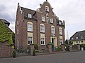
Kamp Monastery
Kamp Monastery is a former Cistercian and Carmelite monastery .
Particularities:
- Order museum: objects from the time of the Cistercian monks. The most valuable exhibit is the Kamper Antependium , an altar curtain from the 14th century.
- Baroque garden reconstructed in 1990 and included in 2004/2005 as an outstanding example in the street of garden art between the Rhine and Maas . There is also the former aristocratic residence Haus Dieprahm, which was completely renovated at the end of the 20th century.

Kamp-Lintfort, Kamp Monastery as seen from the terrace garden
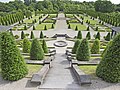
Kamp-Lintfort, Kamp Monastery, terrace garden

Kamp-Lintfort, Kamp monastery, parish church
Kamp-Lintfort, Kamp Monastery, Order Museum


District Hoerstgen
During the time of the Holy Roman Empire, the village was under imperial rule.
- Evangelical church with a working Weidtmann organ from 1732
- Frohnenbruch House , a medieval manor house, first mentioned in 1304.
Eyll
- Good Eyll
- Catholic Church of the Assumption , which was built around 1430.
Friedrich Heinrich colliery settlement
In the early 20th century, the Friedrich Heinrich colliery was built in the style of a garden city . This Altsiedlung is 76 hectares, the largest surviving company town of the Rhenish-Westphalian industrial area and is now after extensive refurbishment and restoration under monument protection . As the westernmost attraction, it belongs to the Route of Industrial Culture .
The miner's house documents the life of miners in 1910 and was opened on March 19, 2006. A complete miner's house from this time was returned to its original state especially for this purpose.
Other museums
- The Geological Museum, which is located in the basement of the school center, has a rich fund of fossils , rocks and minerals that have been found in the area of the colliery. The collection has existed since 1907, but is currently closed for "organizational reasons".
- Private beer museum. Everything here revolves around beer, glasses, bottles, signs, books, etc. Well over 5000 exhibits can be admired in the private beer museum. Almost all 200 breweries that once existed on the Lower Rhine except Diebels and König are represented in the private museum. There is also a second department that deals exclusively with the famous bitters from the neighboring town of Rheinberg, the Underberg.
Culture
State Garden Show 2020

From April 17 to October 11, 2020, Kamp-Lintfort has been the venue for the 2020 State Garden Show . The elaborately reconditioned former mine area of the Friedrich-Heinrich 1/2 mine ( West Mine ) and the monastery garden of the Kamp monastery serve as exhibition space. Due to the corona pandemic, the state horticultural show only opened on May 5th, but the site was open to visitors as planned from April 20th.
music school
In 1991, the Kamp-Lintfort music school opened, the city's first cultural institution. It was expanded to include a dance department in 2004 and has around 1,000 students.
theatre
The free-standing assembly hall of the municipal high school (SGKL) has always served as a multi-purpose hall for a wide variety of events; in the 1980s it was officially renamed "Stadthalle". Cabaret and plays as well as 69 tabloid comedies are offered there several times a year. Every summer there is an open-air theater on the Kamper Berg, designed by the Landestheater Burghofbühne , which attracts around 3000 visitors every year.
movie theater
Long before the founding of the large community of Kamp-Lintfort on February 12, 1950, there were several attempts to establish a cinema. In 1914 the "Apollo-Lichtspiele" were founded on Friedrich-Heinrich-Strasse , followed by the "Film-Palette" ( Moerser Strasse ). After six months of renovation, the movie theater reopened as the “Zentral-Lichtspiele” in 1930. A few years later, the “Glückauf Lichtspiele” opened on Katten-Georg-Straße . In 1955 the "Ring Theater" was built on the Ringstrasse . Today none of these cinemas exist anymore.
However, since the colliery was closed, there are new plans for the construction of a cinema in Kamp-Lintfort. For example, investor Thomas Berger has acquired a 5000 square meter plot of land on the colliery site from RAG Montan Immobilien in order to realize a multiplex cinema for 950 viewers.
Regular events
- Every year on May 1, will be held on Eyller mountain one by ADAC be transmitted Motocross instead -race. The race is also counted for the German championship. The race is organized by the ADAC Motor Club Kamp-Lintfort 1950 eV
A medieval market takes place on the Kamper Berg every two years , where various foods from that time are offered, medieval music is played and artistic performances are also shown. Alternating with the Kamper Nacht, a classical concert in the terrace garden of the Kamp monastery. At the end there will be a music-synchronized fireworks display. The Kamper Night takes place in all odd years.

- Rose Monday procession in all "degrees" years. In odd years the Rose Monday procession takes place in the neighboring town of Rheinberg .
- Spring city festival in May with Sunday shopping.
- Big Kamp-Lintfort Father's Day Fair (May or June)
- Lower Rhine cycling day.
- City festival every first weekend in October with Sunday shopping.
- .Advent markets in Kamp-Lintfort. Kamp-Lintfort does not have its own permanent Christmas market. However, various organizers organize small markets at different locations on 3 Advent weekends.
- 1. Advent weekend: Barbara market
- 2nd Advent weekend: Nikolausmarkt on EK3
- 3rd Advent weekend: Advent market at Kamp monastery
Sports
Of the sports clubs that exist in Kamp-Lintfort, the clubs DJK Kamp-Lintfort (founded in 1926/55, 350 members), Fichte Lintfort (founded in 1914, 500 members), SV Lintfort and Alemannia Kamp are particularly active in the field of football .

Kamp-Lintfort also has three larger riding clubs and the Leucht is a very attractive riding environment for riders . Every year at Easter, RV Seydlitz Kamp organizes an international eventing tournament .
The BG Kamp-Lintfort club is one of the 20 largest basketball clubs in Germany (as of 2011).
At the handball club TuS Lintfort , whose women are active in the 2nd Bundesliga for the 16/17 season, the men won the German field handball championship in the 1958/59 and 1960/61 seasons.
There is also the swimming club Lintforter Swim Club 1957 (LSC) and Taucher Kamp-Lintfort e. V. (founded in 1981, 500 members).
The 1. VV Kamp-Lintfort also offers the opportunity to play volleyball . His first women's team plays in the regional league, the first men's team was promoted to the regional league in 2010. The male A-youth finished seventh in the West German Championship in 2010 and played in the NRW League in the 2010/11 season.
For two-wheelers there is the cycling and motorsport club Frischauf 1912 (RMSV) in Kamp-Lintfort .
Infrastructure and economy
Urban development
In January 2007, the city reached the finals in the so-called T-City competition.
Kamp-Lintfort received funding from the Urban Redevelopment West project , with which the entire area in which the three high-rise buildings previously known as the “White Giants” stood in the city center - building sins in the eyes of many residents - are being re-planned. The first two high-rise buildings were demolished in 2009 and the third blown up in 2010. From the beginning of 2011, a new shopping center called "EK3" was built on the site in eighteen months . The center went into operation on July 5, 2012.
The skyscrapers on Wilhelmstrasse, known as the “colorful giants”, had to give way to the modern cityscape. At the beginning of 2017, the dismantling of the asbestos-contaminated high-rise buildings in the heart of the city began. In addition to the high-rise buildings, an adjacent underground car park and the former city library were also demolished. The city library, known by the media library, moved into its new premises in larger and modernly renovated premises under the town hall. The pedestrian zone next to the town hall was also extensively renovated. The large-scale construction project goes under the name "Rathausquartier". The renovation work should be completed by the end of 2020 and residential and commercial buildings in the best inner city location should be ready for occupancy.
education
In addition to six primary schools, the city has a secondary school, a secondary school, a grammar school and a comprehensive school. On November 28, 2008, as part of the expansion of the NRW university landscape, it was decided that a branch of the newly founded Rhein-Waal University should be built in Kamp-Lintfort . The headquarters of the University of Applied Sciences should be in Kleve . By the winter semester 2010, a total of 2500 interested people should be able to start studying. In Kamp-Lintfort, a building complex was built close to the center on the former ABC site and parts of the neighboring area of the Friedrich-Heinrich colliery. This complex is initially geared towards a number of 2000 study places. The move took place in March 2014.
Transport infrastructure
Bus transport
In local road transport , the SB 30 express bus connects Geldern via Kamp-Lintfort and Moers with Duisburg . The central transfer point is the Neues Rathaus stop, where all bus lines that touch the city area meet. The main bus services are provided by the 911, 2 and SB30 lines. The tariff of the Verkehrsverbund Rhein-Ruhr applies to all local public transport (ÖPNV) and the NRW tariff applies to all tariff areas . It is carried out by NIAG , among others .
- Line directory (as of March 2016)
| line | Line route | Period Mon-Fri (HVZ) |
Cycle Sa (HVZ) |
Cycle Sun (HVZ) |
operator |
|---|---|---|---|---|---|
| 1 | Rhein-Waal University of Applied Sciences - New Town Hall - School Center - Niersenbruch - Fasanenstrasse - Rossenray - Rheinberg - Rhb.-Ossenberg | 60 | 60 | 60 | NIAG |
| 2 | New Town Hall - Dieprahm - Eyller- / Ferdinantenstr. - St. Bernhard Hospital - Bgm. Schmelzing Str. - Kamperbrück Zur Linde | 30 /60 | 30 /60 | 60 | NIAG |
| 7th | New Town Hall - Eyller- / Ferdinantenstr. - St. Bernhard Hospital - Monterkamp - Rheurdt - Neukirchen-Vluyn - Moers | 120 | 120 | - | NIAG |
| SB10 | Duisburg Hbf - Moers - Neukirchen-Vluyn - Kamp-Lintfort Friedrich-Heinrich - New Town Hall | 60 | - | - | NIAG |
| SB30 | Duisburg Hbf - Moers - Kamp-Lintfort New Town Hall - Rhein-Waal / Kamperbrück University - Hoerstgen - Sevelen - Geldern Bf | 60 (30 to Ka-Li, New Town Hall) | 60 | - | NIAG |
| 32 | Moers - Kamp-Lintfort New Town Hall - Eyller- / Ferdinantenstr. - Kamperbrück - Hoerstgen - Sevelen - Issum - Geldern Bf | 60 /120 | 60 /120 | 60 | NIAG |
| 39 ( taxi bus ) | New Town Hall - Fasanenstrasse - Rheinberg-Alpsray (- Rhb.-Millingen - Alps) | 120 | 120 | - | NIAG |
| 076 | Traffic Pavilion - New Town Hall - Eyller- / Ferdinantenstr. - Eyll - Neukirchen-Vluyn - Kempen-Tönisberg - KR-Hüls - KR-Inrath - Krefeld Hbf | 60/120 | 120 | 2 trips | RVN |
| 911 | New Town Hall - Market - Ebertplatz - MO-Repelen - Moers - DU-Homberg - DU-Ruhrort | 15th | 15/30 | 30th | NIAG |
Rail transport
Kamp-Lintfort has a rail link that connects the West mine with the Moers- Rheinkamp transfer station and connects there to the Lower Rhine route . The track systems, which until 2020 were only used to transport coal, are owned by RAG and flow into the network of DB Netz AG in Rheinkamp .
As part of the 2020 State Horticultural Show , public local rail passenger transport will be operated on the previous colliery for the first time . Since May 16, 2020, trains on line RB 31 ( NordWestBahn ) have been running on weekends between Duisburg, Moers and Kamp-Lintfort Süd (stop on Kattenstrasse). This temporary operation will be suspended after the end of the state horticultural show, and from December 2025 the RE 44 line ordered by the Verkehrsverbund Rhein-Ruhr from Bottrop and Duisburg will be permanently extended from Moers to Kamp-Lintfort, for which a new train station is to be built south of the city center.
Between 1909 and 1968, passenger trains also ran on the Rheinberg – Moers – Hoerstgen-Sevelen railway , the terminus of which, Hoerstgen-Sevelen , bore the name of the Kamp-Lintfort district of Hoerstgen, but was entirely in the area of the municipality of Issum- Evelen.
Air traffic
The Kamp-Lintfort (EDLC) special airfield was opened in the Saalhoff district in 1969 . This airfield is approved for the operation of powered aircraft up to two tons maximum take-off weight, for helicopters up to 5.7 tons maximum take-off weight, gliders, microlight flights and hot air balloon operations. There is a 600 meter long grass runway in the 07/25 orientation. AVGAS 100LL, MOGAS / Autosuper Plus and diesel are available as fuel. Further approach aids are an FM -Peiler VDF / QDM and an airfield beacon (ABN). The airfield is operated by the Luftsportgemeinschaft Kamp-Lintfort in the DAeC .
Streets
Kamp-Lintfort is connected to the trunk road network by the federal highways 42 and 57 ( E 31 ) and the federal highway 510 . As an extension of the A 42 , the federal highway 528 was built in December 2006 as a southern bypass of the urban area. From there, the Kamp-Lintfort motorway junction will be connected to the “Gewerbegebiet-Süd” with the third motorway exit next to the motorway junction and the “Asdonkshof” and “Kamp-Lintfort-Süd” exit be extended.
Companies
Kamp-Lintfort was strongly influenced by coal mining for about 100 years . Most of the employees worked in the West Mine , formerly Friedrich-Heinrich , until the end of 2012 . Initially 3500 and finally 1500 employees mined up to three million tons of coal annually. Due to the cessation of subsidized hard coal mining in Germany, coal production ended with the last production shift on December 21, 2012. Coal mining is now a thing of the past on the Lower Rhine.
Another large company was BenQ Mobile , which manufactured cell phones here until January 30, 2007. The BenQ location in Kamp-Lintfort had been insolvent since September 2006 and was closed. In 2005, the Managing Board of Siemens AG made the decision to sell the production of cell phones at the Kamp-Lintfort and Bocholt locations to BenQ.
The former BenQ-Mobile site was acquired by Walter Hellmich in October 2008 and was initially discussed as a location for the Rhine-Waal University of Applied Sciences. The Niederrhein municipal data center (KRZN) is already located on the site and moved here from Moers in 2008.
In 2019, the previous Moers tax office moved into some of the premises of the former mobile phone factory. The tax office will now be called “Finanzamt Kamp-Lintfort”.
Various small and medium-sized companies are located in the north, south and east industrial areas, including a logistics branch of Kaiser + Kraft AG and a well-known food production company in the south area.
Furthermore, the Dieprahm industrial and technology park was laid out west of the south industrial area. This houses various companies in the high technology and service industries. The Institute for Mobile and Satellite Radio Technology (IMST) at the University of Duisburg-Essen is also located there.
Since 1993, the Wesel district has been operating the sometimes controversial waste disposal center (AEZ) Asdonkshof on the eastern city limits. A waste incineration plant with a 200 meter high chimney is attached to this system.
Since 1997, new commercial areas have been developed in the new industrial area Nord / Kamperbruch and in the vicinity of the Rossenray mine. These are populated by a logistics center of the Lidl retail chain , the gravel and construction industry and small and medium-sized companies.

Ampelmännchen in memory of the mining industry


media
In Kamp-Lintfort there is one of six radio workshops of the local radio station Radio KW at the adult education center. Most of the broadcasts of the community radio are produced in these studios . Up until mid-2016 there was an antenna system on the chimney of the Asdonkshof MVA for the British Forces Broadcasting Service program on 105.1 MHz. Previously, until 2012, the Deutschlandradio Kultur program was broadcast from the same location and frequency . When the main station "BFBS" was switched off in Langenberg , the frequency was swapped. Since there is no longer an English military stationed in the wider area, the transmission site in Kamp-Lintfort was abandoned.
sons and daughters of the town
- Johannes Ewich (1525–1588), reformer in Hoerstgen, first graduate doctor in Duisburg and city physician in Bremen
- Friedrich von Eerde (1781–1848), first district administrator in the Geldern district
- Jacob Wiener (1815–1899), engraver of coins, medals and postage stamps
- Johannes Asdonk (1910–2003), doctor
- Wilhelm Ernst Barkhoff (1916–1994), anthroposophist and banker
- Adolf Storms (1919–2010), member of the Waffen SS and war criminal
- Josef Schürgers (1922–2001), politician (CDU), mayor of Viersen
- Heinz Eikelbeck (1926–2011), politician (SPD), 1975–1994 Lord Mayor of Bochum
- Werner Fuchs (1927–2005), painter
- Gerd Ripkens (1929–1988), politician (CDU)
- Karl Günnemann (1931–2015), national handball player
- Ako Haarbeck (1932–2017), Protestant theologian
- Brigitte Asdonk (* 1947), founding member of the terrorist organization Red Army Fraction
- Hans Kämper (* 1949), jazz musician
- Norbert Krüger (* 1949), tropical doctor and university professor
- Yvonne Willicks (* 1970), TV presenter and housekeeper
- Steffen Brückner (* 1976), guitarist, singer (Mrs. Greenbird)
- Tobias Schacht (* 1976), singer and guitarist
- Jennifer Ninaus (* 1985), soccer player
- Florian von Gruchalla (* 1989), handball player
Personalities who worked in Kamp-Lintfort
- Franz Brenner (1863–1928), mine director
- Werner Brand (1885–1957), mine director
- Hubert Lesaar (1888–1963), mayor from 1920 to 1945
- Johannes Egermann (1892–1955), politician (SPD)
- Otto Striebeck (1894–1972), politician (SPD)
- Hanns Vogts (1900–1976), writer
- Karl Isenberg (1906–1977), politician (SPD)
- Rolf Soltau (1917–1980), politician (SPD)
- Rudolf Drese (1932–2003), politician (SPD)
- Eberhard Sohns (1936–2017), politician (SPD)
- Ingo Wolff (* 1938), engineering scientist
- Wolfgang Roth (* 1949), politician (SPD)
- Norbert Ballhaus (* 1955), local politician (SPD)
- Eva-Maria Houben (* 1955), musicologist
- Bernhard Nebe (* 1957), politician (SPD)
- Marcus Uhlig (* 1971), football official
- René Schneider (* 1976), politician (SPD)
Others
One of the most sensational cases of abuse in Germany took place in Kamp-Lintfort in the 1980s, when the schoolgirl Silvia K. was held captive by the Engelbrecht couple for 15 months in a cellar dungeon and brutally abused.
literature
- Georg Geisbauer: Kamp monastery, its abbots and filiations. The Kamper Chronicle - German. Kamp Monastery, Kamp-Lintfort 2002.
- E. Günter Piecha: Kamp-Lintfort in the mirror of history. Rheinland-Verlag, Cologne 1978, ISBN 3-7927-0375-0 (published by the city of Kamp-Lintfort).
- Erich Willicks, Georg Geisbauer: Kamp monastery. History and present. Kamp Monastery, Kamp-Lintfort 2000.
- City of Kamp-Lintfort (Ed.): 50 years of Kamp-Lintfort. Kamp-Lintfort 1999 (Festschrift).
- Hans Kollert: Memories from Camp to Kamp-Lintfort in previously hardly published pictures. Palka, Kamp-Lintfort 1989.
- Jürgen Kwiatkowski, Peter Gottschlich: Kamp-Lintfort. People and monuments. Sutton, Erfurt 2007, ISBN 978-3-86680-092-2 .
- Albert Spitzner-Jahn: Against the red rooster - On the history of fire fighting in Kamp-Lintfort since 1776 , published by the volunteer fire brigade of the city of Kamp-Lintfort, Kamp-Lintfort 1997
Web links
Individual evidence
- ↑ Population of the municipalities of North Rhine-Westphalia on December 31, 2019 - update of the population based on the census of May 9, 2011. State Office for Information and Technology North Rhine-Westphalia (IT.NRW), accessed on June 17, 2020 . ( Help on this )
- ↑ Landscape profile : Ruhr area (BfN) ( Memento from June 4, 2009 in the Internet Archive )
- ^ Map according to the district map of the city of Kamp-Lintfort
- ↑ Website of the city of Kamp-Lintfort: List of city districts (pdf)
- ^ Federal Statistical Office (ed.): Historical municipality directory for the Federal Republic of Germany. Name, border and key number changes in municipalities, counties and administrative districts from May 27, 1970 to December 31, 1982 . W. Kohlhammer, Stuttgart / Mainz 1983, ISBN 3-17-003263-1 , p. 296 .
- ^ Michael Rademacher: German administrative history from the unification of the empire in 1871 to the reunification in 1990. moers.html. (Online material for the dissertation, Osnabrück 2006).
- ↑ 1946 census
- ^ Rheinhausen mining terms. Archived from the original on January 2, 2011 ; accessed on January 1, 2013 .
- ↑ Elections. City of Kamp-Lintfort, accessed on December 23, 2014 .
- ↑ Description of the coat of arms of the town of Kamp-Lintfort
- ↑ Main statute of the city of Kamp-Lintfort, § 2, paragraph 2
- ^ Hermann Habben: Coats of arms, seals and flags in the Moers district. Rheinberg 1962, p. 28ff.
- ↑ Students develop a logo for the city. Retrieved March 12, 2017 .
- ↑ lokalkompass.de
- ↑ NRW hits, old Friedrich-Heinrich settlement
- ↑ Kamp-Lintfort - House of the miner. In: kamp-lintfort.de. Retrieved March 26, 2016 .
- ↑ Kamp-Lintfort - Geological Museum. In: kamp-lintfort.de. Retrieved March 26, 2016 .
- ↑ Landesgartenschau Kamp-Lintfort 2020. Accessed on March 8, 2020 (German).
- ↑ http://filmtheater.square7.ch/wiki/index.php?title=Nordrhein-Westfalen (accessed on January 29, 2016)
- ↑ http://www.rp-online.de/nrw/staedte/kamp-lintfort/stadt-schphia-planungsrecht-fuers-kino-aid-1.5598480 (accessed on January 29, 2016)
- ↑ Kamp-Lintfort | Fixed dates. Retrieved March 9, 2020 .
- ↑ Start. Retrieved March 9, 2020 .
- ↑ Kamp-Lintfort | Fixed dates. Retrieved March 9, 2020 .
- ↑ Kamp-Lintfort | Fixed dates. Retrieved March 9, 2020 .
- ↑ Kamp-Lintfort | Fixed dates. Retrieved March 9, 2020 .
- ^ City of Moers | 29th Lower Rhine cycling day on the Rhine and Maas. Retrieved March 9, 2020 .
- ↑ Kamp-Lintfort - Fixed dates. In: kamp-lintfort.de. Retrieved March 26, 2016 .
- ↑ Kamp-Lintfort | Fixed dates. Retrieved March 9, 2020 .
- ↑ In: Press release of June 21, 2012 . Opening of EK3 on July 5, 2012
- ^ RP ONLINE: Kamp-Lintfort: Demolition of the colorful giants has started. Retrieved March 9, 2020 .
- ↑ North Rhine-Westphalia founds three new universities of applied sciences and expands existing universities of applied sciences. Ministry of Innovation, Science and Research of North Rhine-Westphalia , January 13, 2009, accessed on March 12, 2017 .
- ↑ Green light for Niederrheinbahn. City of Kamp-Lintfort, October 28, 2016, accessed on May 8, 2020 .
- ↑ Kamp-Lintfort: Niederrheinbahn can take off from May 16. Neue Ruhr Zeitung , May 7, 2020, accessed on May 8, 2020 .
- ^ TED preliminary information on the Niederrhein network , accessed on December 22, 2017
- ↑ 37,000 inhabitants, but no train tail (yet). Rheinische Zeitung , May 19, 2019, accessed on May 8, 2020 .
- ↑ Hellmich buys BenQ premises ( Memento from September 24, 2015 in the Internet Archive )

Alps | Dinslaken | Hamminkeln | Hünxe | Kamp-Lintfort | Moers | Neukirchen-Vluyn | Rheinberg | Schermbeck | Sonsbeck | Voerde (Lower Rhine) | Wesel | Xanten