
Rheinberg
| coat of arms | Germany map | |
|---|---|---|

|
Coordinates: 51 ° 33 ' N , 6 ° 36' E |
|
| Basic data | ||
| State : | North Rhine-Westphalia | |
| Administrative region : | Dusseldorf | |
| Circle : | Wesel | |
| Height : | 20 m above sea level NHN | |
| Area : | 75.24 km 2 | |
| Residents: | 30,854 (Dec. 31, 2019) | |
| Population density : | 410 inhabitants per km 2 | |
| Postal code : | 47495 | |
| Primaries : | 02843, 02802, 02803, 02844 | |
| License plate : | WES, DIN, MO | |
| Community key : | 05 1 70 032 | |
| LOCODE : | DE RHB | |
| City structure: | 4 boroughs | |
City administration address : |
Kirchplatz 10 47495 Rheinberg |
|
| Website : | ||
| Mayor : | Frank Tatzel ( independent ) | |
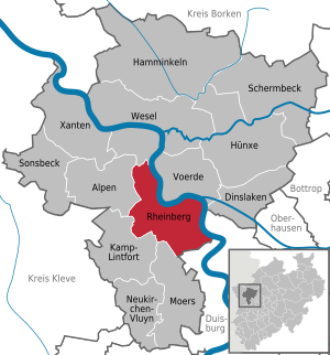
| Location of the city of Rheinberg in the Wesel district | ||
  |
||


The city of Rheinberg is located on the Lower Rhine in the north-west of the Ruhr area in the state of North Rhine-Westphalia and is a central city in the Wesel district in the administrative district of Düsseldorf . It is a member of the Euregio Rhine-Waal and has 31,097 inhabitants (as of December 31, 2018).
To the place name
Rheinberg was originally called Berke (early documents date from 1003, 1106, 1253) or Berka (documented since 1248). The place name was given the explanatory addition Rhein- only in the late 16th century (first documented in 1583), probably to distinguish Berk as Berk am Rhein from other places called Berk or Berg . The early forms of names and spellings were among others Rhenberka , Rhinbergue , Rhynberg , Rhynberck , Rhimberg , Rheinberck , Rheinberk , until Rheinberg finally prevailed. To this day, however, the Rhine prefix can be left out in the dialect (the place is simply called Bäärk ). Contrary to the usual rule, the accent of Rheinberg is often on the second syllable of the locals, i.e. Rheinbérg , another reference to the original name form. There are essentially three approaches to clarifying the origin of Berke or Berka , which are presented below.
Celtic interpretation
The older interpretation by Richard Pick (1883) from the Celtic bior “water” and ka “house”, ie “settlement on the water”, is clearly wrong despite its widespread use, as there are no such words in the given meaning in any Celtic language or class are verifiable. There is indeed a thin layer of place names of Celtic (Gallic) origin on the Lower Rhine, such as B. Dormagen < Duromagus "Kiesfeld", Nijmwegen < Noviomagus "Neufeld" or Metelen < Mediolanum "Middle level", Berke or Berka certainly do not belong to this layer of names .
From Germanic * berga- "hill, mountain"
Kaufmann (1958, 1973) and based on it Berger (1999) assumed an originally Lower Franconian Berkheim "settlement on the (bank) mountain", which was later reduced to Berke . The background is the former high bank location of Rheinberg, which existed until the river was relocated in 1714. However, reducing the home ending to / -e / is rather unlikely; So in the document of 1003, in which Berke is also mentioned, the places Merheim and Stocheim are named, which are now called Mehrum and Stockum , which clearly refers to the original heim forms.
As an alternative, it was suggested that Berke simply be seen as a derivation from the Germanic word * berga- " Anhöhe " (German mountain ), that is, without an original basic word heim . However, the Germanic or Lower Franconian / g / cannot have become an intermediate vowel / k / in Berke or Berka (Tiefenbach 2012). So this option is also ruled out.
From Germanic * berkō or * berkjō "birch"
According to Gysseling (1960) the place name Berke comes from the Germanic word for birch . Derks (2007) and Tiefenbach (2012) also represent this derivation. According to evidence of the early form Berke, Tiefenbach assumes a locative dative, ie "(place) near the birch". The name of the birch is reconstructed in Germanic as * berkō or * berkjō (n) ; The different stem vowels in Berke and Birke result from these two forms . The / e / also shows the place name Berka in Thuringia, while the / i / also predominates in place names, e.g. B. Birklar , Birkenau , Birkenholm and many others.
geography
Spatial location
The city of Rheinberg is located in the Lower Rhine Plain , 15 km south of the district town of Wesel , 11 km north of Moers and about 16 km northwest of Duisburg . In the northeast, the urban area is bounded by the Rhine , which forms the basis of the nature reserves Rhine foreland in the Orsoyer Rheinbogen , Rhine foreland north of the Ossenberger Schleuse and Rhine foreland east of Wallach .

Location on the Rhine
During the time of its existence, Rheinberg and the surrounding area were always in the area of influence of the Rhine, with floods, changing bank lines, new tributaries and river shifts. Today's Rhine bed is no longer directly at the central location. In the Middle Ages, the Rhine River flowed directly to the east of the city wall, until the early modern era as a side arm, whose cave-like remains and a narrow stream are now known as the Old Rhine . In 1713, the Old Rhine was only separated from the nearby main river by a grind (an island covered with rubble, sand and bushes with isolated peasant cottages ), as the drawing by the cartographer Johann Bucker shows. The former Rhyynnberckse Grind is now the area between Rheinberg and the district of Ossenberg (formerly Herrlichkeit Ohsenbergh), largely used for agriculture and adjacent to the Solvay company premises .
From the former Rheinberg fortress, the center of the village is currently surrounded by a 90% preserved former moat, which was built between 1290 and 1311 for the first fortification with city wall and towers. The drained moat is in its present appearance the only remaining structure of this type in North Rhine-Westphalia. The remains of the fortifications that were built back to the foundation walls can still be seen today as remains in the northern and eastern parts of the city.
City structure
Rheinberg is divided into the four urban districts of Borth, Budberg, Orsoy and Rheinberg, which include 15 so-called residential spaces:
- Borough of Borth: Borth , Wallach , Ossenberg
- Rheinberg district: Rheinberger city center with Lützenhof, Annaberg, Millingen , Winterswick , Alpsray , Xantener Straße with Binnenfeld, Mühlenhof
- Budberg district: Budberg , Eversael , Vierbaum
- Orsoy Municipality: Orsoy , Orsoyer Berg
Local dialect
Main article Rheinberger Platt
In Rheinberg and the surrounding villages - in addition to High German, of course - older citizens still speak Rheinberger Platt . This is a Lower Franconian dialect.
history
Beginnings, city elevation and “solid city” Berka
1003 was the first time a village " Berka " (also Berck, Berken or Rheinberk and from around the beginning of the 17th century called Rheinberg by the Dutch) was mentioned in a document. This document was issued by Archbishop Heribert of Cologne in "villa publica Berke dicta" and concerned the exchange of possessions in this area on the Lower Rhine. At that time Berka was probably either a royal court or a settlement that was directly subordinate to the empire.
Rights of the Archdiocese of Cologne can be proven as early as 1106 , since the Archbishop of Cologne Friedrich I assigned the parish church in Rheinberg to the Kunibertstift in Cologne in a document at that time . From when the place belonged to the Archdiocese of Cologne is not exactly verifiable. This affiliation of Berka as the northernmost area of the archbishops on the left Lower Rhine and as "Amt Rheinberg" should have taken place at the latest at the beginning or the end of the 12th century. In the travel descriptions of the Abbey of Deutz from 1155 to 1165 to the properties in the northern areas of the Lower Rhine, stays in Berka, Halet and Mursa (Moers) are mentioned, among others. In a document from 1227, Archbishop Heinrich I von Müllenark confirmed in the " ville nostra in Berke quondeum civic " a wife with her children that she had been ransomed from her "bondage" and that her husband had to pay interest to the Kamp monastery .
In 1233 Heinrich von Müllenark gave the town of Berka permission to build a fortification. At the same time, residents and new residents received civil rights and freedoms comparable to those of Neuss . With that Berka had become a city at that time. These city rights were confirmed by Archbishop Konrad von Hochstaden in 1248 and the citizens were also exempted from bailiff services. The first city fortifications consisted of earth walls and wooden fortifications. These were replaced by a solid curtain wall with cats and towers by the end of the 13th century . In addition, the complex was protected by upstream moats. For the reconstruction of the fortifications, Archbishop Siegfried von Westerburg approved a financial grant from the money raised by the Rhine toll and road money that was collected in the city in August 1290 . In addition to the city fortifications, the electoral palace was also built until 1293. The mighty customs tower reinforced with basalt stones, the lower storey of which is currently still in place, was part of this fortification and its construction was completed at the beginning of the 14th century under Archbishop Wigbold von Holte . The entire construction work for the first city fortifications was carried out by 1311. Systems of this kind marked a fortress city at that time , with the cats and the customs tower being a peculiarity of Rheinberg.
On May 20, 1322, Archbishop Heinrich II von Virneburg gave the city an aldermen and council order. This consisted of twelve people each. The lay judges were elected for life, while the tenure of the city councils was one year. Any new elections and appointments had to be confirmed by the archbishop or his deputy. However, there were sometimes problems with the election of new councilors. For example, at the beginning of the 16th century, 16 councilors were elected instead of 12. Archbishop Philip II von Daun came to Rheinberg personally with his retinue on May 15, 1509 to clarify and revoke the election . A mayor was elected annually on the day of Pauli by the city council. The same applies to the town's rentmaster , who was elected on May 1st each year. Other important events in this period for the city were: 1409 permission to hold a weekly market, 1449 construction of a town hall and around 1460 under Archbishop Ruprecht von der Pfalz permission to mint coins. Two city fires broke out in 1494 and 1567, which resulted in extensive destruction.
Electoral Cologne Office and Rhine toll station Rheinberg
The electoral office in Rheinberg was first mentioned in a document by Archbishop Konrad von Hochstaden in 1253 as the “officiati in Berke” . As the first bailiff, "Hinricus de Bůberg" is listed in a document by Archbishop Siegfried von Westerburg as "officiatus noster in Berka" in 1290. To the Official Rheinberg were next to the town surrounding areas with the court parishes "Winterswick" Issum , Menzelen and "four quarters". In a description for the Rheinberg office from 1636, in addition to the four places listed above, Alpen, Niederbudtberg (only about 50%), Capellen (near Geldern), Gert and Wickradt were given (some names in old spelling). Various farm estates such as Asdonkshof, Haus Glinde, Haus Heydeck, Haus Langerdunk, Haus Lohe as well as some windmills and forest and heather areas were listed. Some areas that were temporarily part of the County of Moers , such as the Strommoers manor or the Moers Lehn-Vogtei Ossenberg, are also included in the list.

In addition to the office, Rheinberg has been an important customs post for a Rhine toll from the Cologne archbishops since the Middle Ages . It is unclear when the first customs permit was issued. The Rhine toll is documented for the first time in 1235 under Archbishop Heinrich von Müllenark , who exempted the Kamp monastery from the Rhine toll in Berka. The next document comes from 1279 under Archbishop Siegfried von Westerburg . The Rhine toll was lifted again in 1293. To secure the Rhine toll , the city was fortified and a tower was built as a customs tower on the banks of the Rhine until the beginning of the 14th century. 1314 confirmed King Friedrich III. the Archbishop Heinrich II of Virneburg the Rhine tariff in Rheinberg, to which various other Kurkölner tariffs had been combined. The Rhine toll of this customs post in Erzköln was no longer in dispute for a long time after this confirmation.
The tariff collection in Rheinberg was frequently interrupted for the archbishops by short-term pledges and, above all, by military occupations and the destruction of the place. At the beginning of the 1370s, Rheinberg's castle, land and Rhine toll were pledged to the County of Kleve. This pledge was redeemed again by Erzköln in 1373 and Count Adolf I von Kleve acknowledged the repayment of the pledge sum of 55,000 gold shields. Loans granted to the archbishops by the Cologne Cathedral Chapter were secured by pledging the Rhine tariffs until they were repaid. For example, the Archbishop Johann Gebhard transferred in 1558 for the repayment of 71,000 guilders, which the predecessor Adolf III. and Anton had received the Rhine toll to Rheinberg to the cathedral chapter.
The mentioned interruption for the collection of the tariffs particularly affected the time of the religious turmoil and the freedom struggle of the Dutch from around the middle of the 16th century. Even after the end of the Thirty Years' War in 1648, Rheinberg was almost constantly occupied by German, Spanish and French troops. After the end of this warlike phase, the Rhine shifted its course by about 2 km to the northeast and Rheinberg was now well west of the Rhine. The result was that the Cologne Rhine toll station in Rheinberg was closed in 1692 and relocated to Uerdingen .
Catholic church and order in Rheinberg

As for the town, there are no exact dates for the first chapel or church in Berka. With the transfer of the Duchy of Lorraine in 953 to Archbishop Brun, the Archdiocese of Cologne received rights to the left Lower Rhine from the middle of the 10th century. The “Duisburg Decanate” of the archdiocese was in Duisburggau, also called Ruhrgau. The dean's office extended to both sides of the Rhine. The administration of these areas changed in the 11th and 12th centuries from the Lorraine to the Rhineland Count Palatine . The church in Rheinberg seems to have been a branch of the church in Repelen at that time . The latter was under the patronage of "Altenberg Abbey" and the local church in Repelen is documented in 1176, but it is probably much older. There are two documents for a church in Berka at that time. In the first, in 1235, the Kamp monastery was given the tithe by the church in Berka and in the second in 1307, the patronage of the church.
A settlement of the Kamp monastery in Rheinberg is documented as early as 1295. The Cistercian order built a house with a chapel and hospice , the Kamper Hof , in the city . In 1317 the Teutonic Order received permission from Archbishop Heinrich II of Virneburg to build a monastery house with a chapel in Berka. These buildings were completed by 1322 and belonged to the Teutonic Knight Order , which was very active in north-eastern Europe at the time. In 1426 the nunnery “St. Barbaragarten ”on today's Beguinage.
With the beginning of the Reformation , a long phase of oppression began for the Catholic Church in the village , starting with the Truchsessischen turmoil with the conquest of Rheinberg in 1583 by Count Adolf von Neuenahr , which began with various brief interruptions until Rheinberg was recaptured by the Prussians in 1702 and their withdrawal in 1715 lasted in the Spanish War of Succession . When the Spaniards under General Spinola expelled the Hollander from Rheinberg in 1606, the Capuchins were able to establish a monastery in the village as the fourth order. Except for the Teutonic Order, the monasteries were secularized in 1802. The latter gave up his branch in Rheinberg in 1809 under the last Komtur for “ Traar and Rheinberg”, “Karl Leopold Freiherr von Kerpen”, according to a decree of April 24, 1809 repealing Napoleon.
History from the end of the 16th century to 1816
The second ring of fortifications was built after the conquest of Rheinberg in 1583 by Count Adolf von Neuenahr , who was the governor of the Dutch and the commander of their troops. The reconstruction of the first fortifications that existed at that time was necessary because they were no longer suitable for an attack with cannons. From 1585 onwards, the Dutch began to convert to the "Berk am Rhein Fortress". This fortification ring included additional defenses outside the city moat: main wall ( curtain wall ) with nine bulwarks , main moat with ten outer works (in the water of the main ditch facilities such as Ravelin or Demi-lune ("half moon")). The third ring of fortifications, also located outside the main trench, comprised a covered path with a low wall and glacis as a defensive system . With the completion of these facilities, Rheinberg was, around 1606 (presumably the end of the construction work), a fortress after "Old Dutch Baumanier", to be precise: irregularly old Dutch. In plain language this means: all works outside the city wall consisted predominantly of earth and earth walls, as these withstood a bombardment with cannons much better.
.jpg)
|
_1654_Matth%C3%A4us_Merian.jpg)
|
|
|
Rheinberg besieged in 1601 by Moritz von Orange . Card J.Blaeu
|
1654 Matthäus Merian, colored city map of RHYNBERG - Rheinberg (North Rhine-Westphalia). Frankfurt am Main, Caspar Merian, 1654.
|
Under the Dutch, a long period of suffering began for the Rheinberger from the end of the 16th century due to the atrocities of war and the frequent suppression of the Catholic faith. The Dutch struggle for freedom against Spain, which had already begun in 1568, was also in full swing on the Lower Rhine with the conquest of Rheinberg in 1585. For Rheinberg, this led to multiple sieges and conquests by Dutch or Spanish troops. The dates for this are as follows: On
- February 3, 1590 the Spaniards conquered Berka under their general Karl von Mansfeld . It was followed by the expulsion of the Spaniards on
- August 20, 1597 by the Dutch under Prince Moritz of Orange and a year later by the Spanish under General Francisco de Mendoza . One day before the conquest on
- On October 15, 1598, a powder tower was hit during a siege of the city by the Spaniards , causing severe damage. Already
- In 1601 the Dutch drove out the Spaniards again under the leadership of Prince Moritz of Orange. The Dutch, for their part, were on
- On October 1, 1606, under Ambrosio Spinola , forced to leave the city again and this was now occupied by the Spaniards for 27 years. Many expropriations of the Catholics among the Dutch were lifted during this period and the orders with their monasteries were active again. The recapture by the Dutch took place on
- June 2, 1633 when the city was handed over to the Dutch and the Spaniards withdrew. Although now the acts of war subsided a little and the Dutch stayed for 39 years it came in
- June 1636 caused a devastating explosion when lightning struck the powder magazine in the castle, in which half the city was destroyed.
Despite the end of the Thirty Years' War in 1648, the fighting on the Lower Rhine was not over. At that time, the city was regarded as the plaything of the warring powers and was referred to as “Rheinberg is a whore of war”. During the Dutch War (1672–1678), the French troops Louis XIV from Rheinberg in June 1672 betrayed the Dutch and forced them to capitulate and withdraw. This led to an end to the oppression of the Catholics with the return of the city church and the revival of the monasteries.
Rheinberg was also affected by the War of the Spanish Succession (1701–1714). On November 27, 1701, French troops under "Marques de Grammont" conquered the city after a siege. The Prussians, as opponents of the French, then besieged the fortress from 1702. The French capitulated on February 10, 1703 and withdrew from this area of the Lower Rhine. Under the Prussians, the Rheinberg office was under the Duchy of Cleves and the fortifications were destroyed. In April 1715, the Prussians left Rheinberg and the Rheinberg office was returned to the Archdiocese of Cologne.
From 1741 onwards, Elector Clemens August von Bayern had the Rheinberg fortifications partially refurbished. During the Seven Years' War from 1756 to 1763, Kurköln was part of the alliance of the opponents of Prussia. Although both the battle near Rheinberg on June 16 and then on June 23, 1758 the battle near Krefeld and the battle near Kamp monastery in 1760 took place in the immediate vicinity, this time the Rheinberg urban area was spared from destruction. The next few years to the middle of the last decade of the 18th century were peaceful. However, the three now dilapidated city gates were demolished in 1777.
All Saints' Day 1794 French revolutionary troops occupied Rheinberg again in the First Coalition War and stayed there until 1814. On November 4, 1797, the entire area on the Lower Rhine was annexed by France. Rheinberg was now a French mairie in the Département de la Roer and feudalism was replaced by a civil constitution with the civil code. The annexation was legally recognized by the German states with the Lunéville Peace on March 9, 1801.
The French interlude ended after the defeat of Napoleon in 1813 and the withdrawal of French troops from the left Lower Rhine in January 1814. First, Prussia became provisional in 1814 and finally, after the peace treaty and the end of the Congress of Vienna in 1815, it became sovereign of the entire left Lower Rhine. Under the Prussian administration, the old administrative structures on the Lower Rhine were largely restored. The former duchies of Jülich-Kleve-Berg were combined with the Kurkölner areas in this area on April 30, 1815 to form the province of Jülich-Kleve-Berg . From April 1816 the Rheinberg district was formed, which belonged to the Kleve administrative district.
Second World War
During the Second World War , strong anti-aircraft units of the Wehrmacht were in the area of the municipality. These were part of the anti-aircraft units that were supposed to protect the Ruhr area. After Germany surrendered, the Americans set up a large prisoner-of-war camp near Rheinberg. These camps were also known as Rhine meadow camps . In the first months after the war, it is estimated that up to 200,000 prisoners of war were interned in the Rheinberg camp. Since there was no accommodation or sanitary or medical facilities in the camp for a few months, the Rheinberg camp was one of those with the highest mortality rates. The German Red Cross organized aid deliveries for the prisoners in the camp early on. The collection point for this was then in the former Germania building at the train station.
Territorial reform
The Rheinberg district, formed in 1816, was one of over 40 districts in the Jülich-Kleve-Berg province , but it was merged with the Geldern district as early as 1823 . This association was reversed in 1857. From then on, Rheinberg belonged to the Moers district . On January 1, 1972, the poorly populated municipality of Orsoy-Land was incorporated. On January 1, 1975, the previously independent town of Orsoy and the formerly independent communities of Borth and Budberg were added as part of the second reorganization program . Since January 1, 1975, Rheinberg has belonged to the Wesel district , in which the former Moers district was merged.
politics
City council
Frank Tatzel ( independent ) has been mayor of the city of Rheinberg since 2015 .
According to the results of the 2014 local elections, the 46 seats in the city council are distributed among the individual parties as follows:
Political party |
Seats
|
| Christian Democratic Union | 16 |
| Social Democratic Party of Germany | 14th |
| Alliance 90 / The Greens | 8th |
| Free Democratic Party | 2 |
| The left | 2 |
| Non-attached | 4th |
In the 2014 local elections , the CDU won 20 seats on the council. However, four council members left the CDU parliamentary group during the legislative period and are non-attached council members in the Rheinberg council.
Town twinning
Rheinberg maintains partnership relationships with the French community of Montreuil , France and the Saxon city of Hohenstein-Ernstthal .
Coat of arms, seal, banner, flag and logo
The city of Rheinberg was granted the right to use a coat of arms , a seal and a flag ( banner ) in a certificate from the Interior Minister of North Rhine-Westphalia dated July 20, 1961 . The city also has a logo .
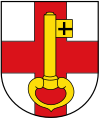
coat of arms

Coat of arms of the former city of Orsoy
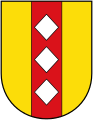
Coat of arms of the former municipality of Borth

Coat of arms of the former municipality of Budberg
seal

banner

flag

logo


Blazon : The coat of arms bears a red bar cross on a silver background, which is covered with an upright golden key with a beard pointing to the left.
The historic city seal was awarded to Rheinberg by the sovereign at the time when it was elevated to the city. It depicts St. Peter, who, surrounded by a crenellated wall, sits on a chair and holds a flag in each of his hands. This large seal is only used for particularly significant notarizations (honorary citizenship, etc.). The smaller official seal in use since the end of the 18th century contains the emblems of the coat of arms, namely the cross and key.
The flag bears a red cross with a yellow key on a white background. It can have the shape of a banner as well as that of a flag ( hoist flag ).
Culture, religion and sights
Buildings in the Rheinberg district
![]() Map with all coordinates of the buildings section of the Rheinberg district : OSM
Map with all coordinates of the buildings section of the Rheinberg district : OSM
- → see also: List of architectural monuments in Rheinberg
The partly preserved city fortifications are among the most important buildings and sights. This includes the Alte Kellnerei ( ⊙ ), which was added to the archbishop's electoral castle from the 13th century as a farm building in 1573. This was built at the same time, between 1292/93 to 1298, with the Rheinberger Zollturm ( ⊙ ). After several explosions, in which the former castle was largely destroyed, and the razing of the fortifications, the building , which was also used as a powder tower , has only survived as a ruin and is located a little more than a hundred meters east of the old winery. Also visible are the ramparts with the outer, inner and east ramparts, which are around two kilometers long and frame the historic city center of Rheinberg.

Ramparts


The oldest sacred structure is the Catholic parish church of St. Peter ( ⊙ ), which is located east of the market square and was first mentioned in a document in 1106. The current building was built at the end of the 12th century. The church, equipped with a late Romanesque , five-storey west tower , is Gothic . The choir windows are by Friedrich Stummel and Egbert Lammers . The furnishings include a high altar , which combines several shrines from the 15th and 16th centuries, a baroque pulpit from 1701 and a Weimbs organ from 2009 with a prospectus from 1769. South of the church is the old rectory ( ⊙ ), which was built in 1729 in Dutch classicism. The parish of St. Peter also includes the church of St. Anna ( ⊙ ) in the Annaberg district on the hill of the same name . This was built in 1983 with a modern pentagonal floor plan by the architect Heinz Dohmen , Essen cathedral master builder. The Protestant parish church of Rheinberg ( ⊙ ) is located in the northern part of the city center. The hall church is located in a barn built in 1464, in which services were held with interruptions from 1686 by the congregation founded in 1580 and has been the main church since 1721. In 1885/86 a neo-Romanesque church tower was added to the former barn. From 1764 to 1897 there was another sacred building, the synagogue in the house in the White Cross ( ⊙ ). Today ten stumbling blocks in Gelderstrasse remind us of the fate of the people who were persecuted, murdered, deported , expelled or driven to suicide during the Nazi era .

Catholic Church of St. Peter

inside view

Old rectory

St. Anna in Annaberg


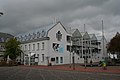
In the market place, come to the west of the wood and fish market and the east of the church square, the Gothic is Old Town Hall ( ⊙ ) from 1449. The baroque in 1700 transformed onion tower was in 1674 attached to the three-story brick building. The house Im Scheffel ( ⊙ ), which is dated to the year 1560, is located south of the town hall . The grain storage house in the Lower Rhine ensured that bread was supplied from the grain store at the time of the Rheinberg siege during the Eighty Years' War . In the southeast of the market is the building Zum Weisse Raben ( ⊙ ) from the 17th century, the only baroque house in Rheinberg. In addition, on the market is Gottfried Böhms Stadthaus ( Rath ), today's seat of the town hall and the city administration, as well as the headquarters of the Rheinberg spirits company Underberg , the Underberg Palais ( ⊙ ). It was built from 1878 to 1880 and designed by the architect Ernst Giese . Today it is only used for representative purposes; the company archive is also housed there. In the southwest, the former herb tower ( ⊙ ), known as the Underberg tower , adjoins the main building. The skyscraper, which was scaffolded for a long time due to the conversion to a hotel, is 53 meters high. There is a chapel ( ⊙ ) near the Underberg tower , which was built in 1494. It was part of the Kamper Hof , the former settlement of the Cistercian order of the Kamp Abbey from the 13th century. The former chapel, now a restaurant , served in its history, among other things, as the quarters of the fortress governors during the Eighty Years' War and as a Kolping House .

"In the bushel"

"To the white raven" before the renovation
Townhouse

Underberg Palais

Underbergturm


Almost a hundred meters east of the Catholic Church of St. Peter is the War Honor and Memorial Gate of the Dead ( Ost ), designed by Toni Hermanns , on the east wall . It consists of two concrete steles, in the middle of which there is a bronze sculpture by Fritz Koenig , next to it a cube-shaped stone used as a chest, which contains a parchment roll with 650 names of war victims. The English military cemetery Rheinberg War Cemetery ( ⊙ ) is located outside Rheinberg, near the city limits of Kamp-Lintfort . The symmetrically designed complex, laid out in April 1946, counts 3326 graves of nationally fallen dead from different nations.


The Stadtpark ( ⊙ ) dates back to 1790, when Rheinberg's first urban green area was created. The sights of today's monument area include the Underberg-Bad ( ⊙ ), an outdoor swimming pool built in 1954, and the Spanish Vallan ( ⊙ ), a small, hexagonal and seven-meter-high residential tower.
North of Winterswick is an industrial park of the TerraZoo ( ⊙ ). The Reptilium , founded in 1996, has around 400 animals of a hundred different species.


Regular events
- LaufSpektakel-Rheinberg
- Music Art Project
- City bikes
- TOGETHER / ART!
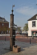
Pump neighborhoods
An important historical aspect of the cultural life in Rheinberg are the historical pump neighborhoods . These are neighborhood associations of individual streets, which have their origins in securing the common water supply.

Pump from the “Fischmarkt” pump neighborhood on Entenmarkt

Pump neighborhood Orsoyer Tor
Pump at the Holzmarkt


Denomination statistics
According to the 2011 census , in 2011 43.2% of the population were predominantly Roman Catholic , 31.4% Protestant, and 25.4% were non-denominational , belonged to another religious community or did not provide any information.
Infrastructure and economy
traffic
Rail transport

Rheinberg has two train stations, the centrally located Rheinberg (Rhineland) train station and the Millingen train station, which is also used as a freight station, in the district of the same name. The cities of Duisburg , Xanten and Moers , among others , can be reached via both stations .
Bus transport
In Rheinberg there are bus connections to the district town of Wesel (line 68), to Alpen (line 38), Moers (line 68 and 913), Xanten (line 65) and Kamp-Lintfort (line 1).
Line directory (as of June 2011)
| line | Line route | Period Mon-Fri (HVZ) |
Cycle Sa (HVZ) |
Cycle Sun (HVZ) |
operator |
|---|---|---|---|---|---|
| 1 | Ossenberg - Solvay - City Hall - Rheinberg Bf - Kamp-Lintfort New City Hall | 60 | 60 | 60 | NIAG |
| 8th | School Center - Town Hall - Budberg - Primary School Kiefernweg - Primary School Lutherstr. - Vierbaum - Vierbaumer Heide - Baggerstrasse | just on schooldays | - | - | NIAG |
| 38 | Rheinberg Bf - Town Hall - School Center - Messe Niederrhein - Alpsray - Millingen - Alps (Alpen-Bönninghardt) | 60 | 60/120 | - | NIAG |
| 65 | Rheinberg Bf - Town Hall - Solvay - Alps - Alpen-Menzelen - WES-Ginderich - Xanten-Birten - Xanten Bf | single trips | - | - | RVN |
| 68 | Moers - Rheinberg-Winterswick - Hospital - Town Hall - Solvay - Ossenberg - Borth - Wallach - WES-Büderich - Wesel Bf | 60 | 120 | 120 | RVN |
| 913 | (School center -) Messe Niederrhein - Annaberg - Rheinberg Bf - City Hall - Budberg / Eversael - Orsoy - Vierbaum - DU-Baerl - Moers - Moers-Hülsdonk industrial area | 30 /60 | 60/120 | 120 | NIAG |
In addition, a citizen's bus runs between Wallach and Orsoy through the city from Monday to Friday . The journey costs between 1 and 2 euros, depending on the length of the route. VRR tickets are not valid.
Roads and ferries
Rheinberg is connected to the trunk road network by the federal highways 42 and 57 ( E 31 ) as well as the federal highways 57 and 510 .
A car ferry runs from Rheinberg-Orsoy to Duisburg - Walsum ( Rheinstrom-km 793).
Waterways and ports
,_Rhine_and_Duisburg-Walsum.JPG)
On the Rhine is in the district Orsoy the harbor Orsoy (Rhine km 794) operated. Loaded and unloaded goods here are coal and ore.
In the district of Ossenberg (Rheinberg) - at Rhine kilometer 806 - is the Ossenberger Rheinhafen . There, the company ESCO (formerly Deutsche Solvay Werke ) loads large quantities of salt that comes from the Borther rock salt mine and is transported to the port on a company's own rail link. The port is also used to deliver limestone, which the Deutsche Solvay works in Rheinberg need for the production of soda.
economy

The local industry is characterized, among other things, by Solvay's chemical production facility (around 400 employees). The esco company operates rock salt mining in the area. The formerly strong textile industry no longer exists. After a few years of purely administrative work, the Swiss Underberg group, originally founded in Rheinberg, is again producing bitters in Rheinberg. However, bottling continues to take place in Berlin-Heiligensee . In 2004 a logistics center of the discounter Aldi was opened.
In 2001 the first citizen-financed wind farm was founded in North Rhine-Westphalia. The Bürgerwindräder Rheinberg GmbH & Co. KG has been operating five wind turbines with a total nominal output of 5 MW since 2003.
The Amazon Group has been operating in Rheinberg since mid-2011 . With 110,000 square meters, the Amazon logistics center in Rheinberg is one of the largest Amazon locations in Europe.
Other resident companies are Solvay GmbH and Aumund Fördertechnik in Millingen.
schools
The Amplonius Gymnasium is the most popular school in town. Its history goes back to the year 1337. The Rheinberg school center is located opposite the Amplonius grammar school. At the beginning of the 2011/12 school year, one of a total of 12 community schools approved in North Rhine-Westphalia (school trial) began operations there, and secondary and secondary schools were closed for each year. The city of Rheinberg has six primary schools, two of them in the city center and four in the districts of Millingen, Orsoy, Budberg and Wallach. Since the beginning of the 2010/11 school year, the school building in Ossenberg has been a sub-location of the Gem.-Grundschule in Borth-Wallach ("Schule am Deich"). Also since August 1, 2010, the primary schools Grote Gert and Paul Gerhardt (both located in Rheinberg-Mitte) have formed a primary school network. There are a total of sixteen kindergartens.
sports clubs
There are seven sports clubs in Rheinberg. The names of the clubs are:
- TuS 08 Rheinberg
- TuS Borth
- SV Concordia Ossenberg
- SV Millingen
- SV Orsoy
- SV Budberg
- TKD Yong Ho e. V.
media
Local newspaper editors are the local editors of the daily newspapers NRZ / WAZ and Rheinische Post .
Personalities
Honorary citizen
- Gerhard van Clev , Mayor
- Johann Josef Kewer (1810–1903), notary and local writer
- Aloys Wittrup (1877–1961), theologian and educator
sons and daughters of the town
- Amplonius Ratingk de Berca (1363 / 64-1435), scholar
- Franz Eugen von Seida and Landensberg (1772–1826), historian and graphic artist
- Ludwig Georg Delius (1807–1866), overseas merchant and founder of Louis Delius & Co
- Franz Bücheler (1837–1908), philologist
- Friedrich Horn (* 1875 in Orsoy; † 1957), Protestant theologian
- Wilhelm van Laak (1881–1956), doctor and politician
- Milly Steger (1881–1948), sculptor
- Hubert Lesaar (1888–1963), mayor of Kamp-Lintfort from 1920 to 1945
- Erich Brautlacht (1902–1957), lawyer and writer
- Christa Dericum (1932–2014), writer
- Heinz-Joachim Weber (* 1943), former director of production and technology at WDR
- Klaus Zumwinkel (* 1943), former CEO of Deutsche Post AG
- Josef Walch (* 1946), professor of art didactics and textbook author
- Norbert Richtsteig (* 1948), episcopal church music director and cathedral organist
- Brigitte Mohnhaupt (* 1949), ex-member of the Red Army faction
- Didi Schaak (* 1951), actor
- Kurt Bodewig (* 1955), former Federal Minister (SPD)
- Eva-Maria Houben (* 1955), composer, organist, pianist and musicologist
- Thomas Baumgärtel (* 1960), artist
- Claus Lufen (* 1966 in Orsoy), television presenter and sports reporter
- Thomas Wagner (* 1967), cultural sociologist and author
- Claudia Schiffer (* 1970), model and actress
- Robert Bongen (* 1974), television journalist
- Marcel Rolf Hoffmann (* 1975), actor and singer
- Astrid Stienen (* 1979), triathlete
- Nadine Hentschke (* 1982), former athlete
Personalities related to Rheinberg
- Herbert Nikolaus Lenhof (* 1936 in Völklingen-Wehrden; † October 13, 2017 in Limburg an der Lahn) was Bishop of Queenstown / South Africa; after ordination worked in the Pallottine Konvikt in Rheinberg
- Jürgen Möllemann (* 1945 in Augsburg, † 2003 in Marl-Loemühle), former Federal Minister; attended the Amplonius High School
- Ernst Kausen (* 1948 in Rheinhausen), professor of mathematics, linguist; grew up in Rheinberg, attended the Amplonius grammar school
- Ursula Kamizuru (* 1953 in Sennfeld, † 2008 in Wesel), table tennis player; lived in the borough of Borth until the end
- Isabell Werth (* 1969 in Sevelen ), dressage rider and Olympic champion; attended the Amplonius High School
literature
history
- Ute Geißler: The city of Rheinberg on the Lower Rhine and its fortifications. Writings of the city of Rheinberg on history and local history. Volume 8. 1995.
- Ludwig Küsters: The Rheinberg fortress in the Electorate of Cologne is a plaything of foreign nations. 2nd Edition. 1967.
- Landschaftsverband Rheinland (Hrsg.): Rheinberg ( Rheinischer Städteatlas ). 1982, ISBN 3-7927-0726-8 .
- Richard Pick : On the history of the city and the former Rheinberg office. In: Annals of the historical association for the Lower Rhine, especially the old archdiocese of Cologne 39 (1883), p. 1 ff. ( De.wikisource.org ), accessed on March 1, 2012
- Aloys Wittrup: From Rheinberg's past days. Schiffer, Rheinberg 1955.
To the place name
- Dieter Berger: Geographical Names in Germany. Duden Taschenbücher Volume 25. Dudenverlag, Mannheim 1999.
- Paul Derks: The settlement name Rheinberg. A reply. In: The Lower Rhine. Journal for home care and customs. Krefeld, born 2007.
- Maurits Gysseling: Toponymically Wordenboek van Belgie, Nederland, Luxemburg, Noord-Frankrijk en West-Duitsland (vóór 1226). Tongeren 1960.
- Henning Kaufmann: West German place names with distinctive additions. Including the place names of the Germanic language area bordering to the west. Part I. Heidelberg 1958.
- Henning Kaufmann: The names of the cities in the Rhineland. Munich 1973.
- Heinrich Tiefenbach: Rheinberg. In: Manfred Niemeyer (Ed.) German book of place names. De Gruyter, Berlin - Boston 2012.
Web links
- Website of the city of Rheinberg
- Research in the Rheinberg municipal archive - access via the NRW municipal archive
- Ernst Kausen, On the place name "Rheinberg" (basis for the section "On the place name" in this article; DOC file; 48 kB)
- Ernst Kausen, remarks on Derks' "Against Word" 2007, with added comments from Derks 2013 (DOC file; 56 kB)
- Annals of the historical association for the Lower Rhine, 1883, Cologne, 39th issue
Individual evidence
- ↑ Population of the municipalities of North Rhine-Westphalia on December 31, 2019 - update of the population based on the census of May 9, 2011. State Office for Information and Technology North Rhine-Westphalia (IT.NRW), accessed on June 17, 2020 . ( Help on this )
- ↑ Erich Wisplinghoff, explanations from 1984 on: Johann Bucker, map of the Rhine from Duisburg to Arnheim from 1713, publisher: Nordrhein-Westfälisches Staatsarchiv, Düsseldorf 1984, p. 5–10.
- ↑ Richard Pick. In: Annals of the historical association for the Lower Rhine, in particular the old archdiocese of Cologne. Section: On the history and the former office of Rheinberg . 1883, No. 39, pp. 140, 130. Online version
- ^ In: Journal: Niederrheinischer Geschichtsfreund. No. 11 . 1882, p. [87] 83. Online version
- ^ In: Journal: Niederrheinischer Geschichtsfreund. No. 11 . 1882, p. [80] 76. Online version
- ↑ Richard Pick. In: Annals of the historical association for the Lower Rhine, in particular the old archdiocese of Cologne. Section: On the history and the former office of Rheinberg . 1883, No. 39, pp. 142, 132. Online version
- ↑ a b c d Richard Pick. In: Annals of the historical association for the Lower Rhine, in particular the old archdiocese of Cologne. Section: On the history and the former office of Rheinberg . 1883, No. 39, pp. 144-146, 134-136. Online version
- ↑ Richard Pick. In: Annals of the historical association for the Lower Rhine, in particular the old archdiocese of Cologne. Section: On the history and the former office of Rheinberg . 1883, No. 39, p. [11] -. Online version
- ↑ Richard Pick. In: Annals of the historical association for the Lower Rhine, in particular the old archdiocese of Cologne. Section: On the history and the former office of Rheinberg . 1883, No. 39, p. [149] 139. Online version
- ↑ Richard Pick. In: Annals of the historical association for the Lower Rhine, in particular the old archdiocese of Cologne. Section: On the history and the former office of Rheinberg . 1883, No. 39, pp. [13 to 42] 3 to 32. Online version
- ^ Friedrich Pfeiffer: Rheinische Transitzölle in the Middle Ages. Akademie Verlag, Berlin, 1997, pp. 289, 290.
- ↑ Lacomblet, Theodor Joseph: Document book for the history of the Lower Rhine or the Archbishopric of Cologne, document no. 139. Volume 3, 1853, p. [124] 104. Digitized edition ULB Bonn
- ^ Friedrich Pfeiffer: Rheinische Transitzölle in the Middle Ages. Akademie Verlag, Berlin, 1997, p. 292.
- ↑ Lacomblet, Theodor Joseph: Document book for the history of the Lower Rhine or the Archbishopric of Cologne, document no. 737. Volume 3, 1853, p. [645] 633. Digitized edition ULB Bonn
- ↑ Lacomblet, Theodor Joseph: Document book for the history of the Lower Rhine and the Archbishopric of Cöln, certificate 561. Volume 4, 1858, p. [729] 703. Online edition 2009 nbn-resolving.de
- ↑ Walther Föhl. In: Uerdinger Bibliography. 1965, p. [92] 86. Online version
- ↑ Richard Pick. In: Annals of the historical association for the Lower Rhine, in particular the old archdiocese of Cologne. Section: On the history and the former office of Rheinberg . 1883, No. 39, p. [141] 131. Online version
- ↑ Richard Pick. In: Annals of the historical association for the Lower Rhine, in particular the old archdiocese of Cologne. Section: On the history and the former office of Rheinberg . 1883, No. 39, p. [51] 41. Online version
- ↑ Kilian Müller. In: Rheinberg and the Capuchins . 1908, Cologne, p. 16 12. Online version
- ↑ Richard Pick. In: Annals of the historical association for the Lower Rhine, in particular the old archdiocese of Cologne. Section VI. Register of documents of the German Order Coming to Rheinberg . 1883, issue 39, p. [55] 45. Online version
- ↑ Illustration by Frans Hogenberg from 1606: Wiewoll Rheinberck gar woll bestatt, Vill Volck and notturfft in im hatt, The enemy is strongly resisting, ... ( digitized version )
- ↑ Kilian Müller. In: Rheinberg and the Capuchins . 1908, Cologne, pp. [15 + 16] 11 + 12. Online version
- ↑ a b c d e Richard Pick. In: Annals of the historical association for the Lower Rhine, in particular the old archdiocese of Cologne. Section: On the history and the former office of Rheinberg . 1883, No. 39, pp. [147-149] 137-139. Online version
- ↑ a b Federal Statistical Office (ed.): Historical municipality register for the Federal Republic of Germany. Name, border and key number changes in municipalities, counties and administrative districts from May 27, 1970 to December 31, 1982 . W. Kohlhammer, Stuttgart / Mainz 1983, ISBN 3-17-003263-1 , p. 296 .
- ↑ Frank Tatzel is the new mayor of Rheinberg
- ↑ Election archive of the municipal computing center Niederrhein (KRZN)
- ^ Council information system of the city of Rheinberg
- ↑ Main statute of the city of Rheinberg of June 29, 2017 in the version of the 1st amendment of March 12, 2019 , § 2
- ^ City of Rheinberg Religion , 2011 census
- ↑ Stadt Rheinberg statistics figures , accessed on April 25, 2020
- ^ Rheinberg Citizens' Bus
Remarks
- ↑ The farming communities "Camperbrück, Linfort, Rosenray and Saalhof (Hoerstgen)" were grouped under four quarters.

Alps | Dinslaken | Hamminkeln | Hünxe | Kamp-Lintfort | Moers | Neukirchen-Vluyn | Rheinberg | Schermbeck | Sonsbeck | Voerde (Lower Rhine) | Wesel | Xanten