
Wesel district
| coat of arms | Germany map |
|---|---|

|

Coordinates: 51 ° 39 ' N , 6 ° 37' E |
| Basic data | |
| Existing period: | 1975– |
| State : | North Rhine-Westphalia |
| Administrative region : | Dusseldorf |
| Regional association : | Rhineland |
| Administrative headquarters : | Wesel |
| Area : | 1,042.8 km 2 |
| Residents: | 459,976 (Dec. 31, 2019) |
| Population density : | 441 inhabitants per km 2 |
| License plate : | WES, DIN, MO |
| Circle key : | 05 1 70 |
| NUTS : | DEA1F |
| Circle structure: | 13 municipalities |
| Address of the district administration: |
Reeser Landstrasse 31 46483 Wesel |
| Website : | |
| District Administrator : | Ansgar Müller ( SPD ) |
| Location of the Wesel district in North Rhine-Westphalia | |
  |
|
The Wesel district is a district in North Rhine-Westphalia . It is located on the Lower Rhine and on the northwestern edge of the Ruhr area . It belongs to the administrative district of Düsseldorf and is a member of the Rhineland Regional Association , the Ruhr Regional Association and the Euregio Rhein-Waal . The seat of the district is the city of Wesel .
geography
location
The Wesel district with its total area of 1042.4 km² and a diameter between 45 and 48 km is a district of the Lower Rhine and at the same time a link between the Rhine-Ruhr metropolitan region and the Netherlands . 45 percent of the district area (the cities of Dinslaken, Kamp-Lintfort, Moers, Neukirchen-Vluyn, Rheinberg, Voerde and Wesel) belong to the urban fringe zone, in which around 80 percent of the district's residents live. However, the development of the district is particularly determined by its location on both sides of the Rhine . The coordinated use of the Rhine rail was the main argument for the formation of districts crossing the Rhine in 1975. With 44 km on the left bank and 30 km on the right bank of the Rhine , the Wesel district has the largest share of the Rhine in North Rhine-Westphalia. The Lippe and the Wesel-Datteln Canal (length in the district area each 23 km) flow into the Rhine in Wesel.
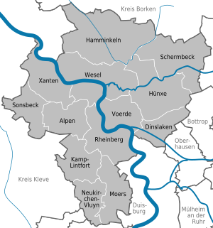
Communities
The Wesel district is divided into 13 municipalities belonging to the district , of which six are medium-sized towns and three are large towns .
(In brackets the population figures as of December 31, 2019)
|
Other communities
|
  |
Landscape and nature
During the Tertiary , the district was flooded by the sea as far as the Cologne Bay , so that up to 300 m thick clay and sand sediments were deposited, some of which are still mined in the eastern district today. Some of the clay pits that have not been refilled have developed into valuable habitats, such as today's Lichtenhagen near Schermbeck nature reserve .
In the course of the Quaternary , gravel and sand deposits formed in the widely branched river system of the Rhine, which can still be recognized today as terraces . During the first glacial period, a first main terrace was created, which reached as far as the eastern boundary of the district and extended to the Meuse in the west . The following cold periods formed the lower terrace , which was mainly made of gravel and sand , which today occupies large parts of the Lower Rhine lowlands and is used in particular for gravel extraction. Furthermore emerged moraines as the "Sonsbecker Switzerland" in Sonsbeck that "Hees" in Xanten and the inland dunes in "Diersfordter forest" near Wesel.
The former courses of the Rhine and streams called Kendel and Leyen are typical landscapes in the district, as are the elevations called Donken . During the 18th century, the Rhine was gradually straightened and dykes were laid in the entire district , which cut off large parts of the previously between 4 and 6 km wide Rheinaue from the Rhine and its floods and dried up. Some of the then loops of the Rhine were thereby separated from the course of the river and have partly been preserved to this day, as well as a few backwaters of the Rhine which are designated as "seas" and which, like the "Bislicher Meer", are mainly designated as nature reserves. One of the only two largely intact floodplain landscapes in the district is the Bislicher Insel nature reserve with the Xanten Old Rhine , the second floodplain can be found in the "Lippeaue" nature reserve near Schermbeck. The majority of the former Rhine floodplains are now occupied by dyke foreland, which are mainly used for agriculture as green areas.
There are 73 nature reserves in the district with a total area of 131 km². The remaining floodplains and the dike foothills serve today as an important wintering area for over 60,000 arctic wild geese and ducks. Around 40 bird species on the Red List nest in these areas. Due to this great importance as a habitat, large parts of the former Rheinaue in the Wesel and Kleve districts and the city of Duisburg are protected as a wetland "Lower Lower Rhine" and as a bird sanctuary of the same name, in particular for agricultural use and the extraction of gravel, sand and salts in to reduce these areas. In other parts of the district, too, there used to be extensive wetlands and meadow areas, of which only a few, such as the “Dingdener Heide” nature reserve, have been preserved due to intensive agricultural use.
Further nature reserves were set up in the heathland, which has become extremely rare in the district, such as the "Loosenberge" near Schermbeck and the Rabbit Mountains near Hünxe. Furthermore, a large number of heather moors are under nature protection, for example the areas of Schwarzes Wasser , “Schnepfenberg”, Großes Veen and the “Aaper Vennekes”. In order to continue to ensure the protection of nature and landscape, landscape plans were initially drawn up for the areas of Hünxe / Schermbeck, Hamminkeln and Sonsbeck / Xanten, and soon afterwards also for the areas of the Alps / Rheinberg, Dinslaken / Voerde and Wesel.
Neighboring districts or cities
The district of Wesel borders, starting in the north in a clockwise direction, on the districts of Borken and Recklinghausen , on the independent cities of Bottrop , Oberhausen , Duisburg and Krefeld and on the districts of Viersen and Kleve .
history
The Wesel district, like almost all districts in North Rhine-Westphalia, was created on January 1, 1975 as part of the second reorganization program . With the Lower Rhine Act of July 9, 1974, essential parts of the former districts of Dinslaken , Moers and Rees were merged with parts of the districts of Borken and Recklinghausen to form the new district of Wesel. Before that, on July 1, 1969, in the first phase of the reorganization, the territorial reform at the municipal level was partially anticipated. For the territorial reform of the districts a number of principles were developed, which aimed to enlarge the existing units. The minimum size was 150,000, in densely populated areas even 200,000 inhabitants. Otherwise, the principles of the state development plan had to be taken into account, according to which the districts should represent economic units and should have a balanced variety of sub- centers and medium-sized centers within their boundaries . Development axes were not allowed to be borders, but should be cut across because of the interdependence of mutual use.
Based on these principles, the new Wesel district was formed on January 1, 1975 through the amalgamation of communities in the districts of Dinslaken , Moers and Rees with a total area of 1,042 km² and a population of 387,000 at that time. In terms of population, it was the fifth largest of the 31 districts in North Rhine-Westphalia. The area of Wesel lies above the North Rhine-Westphalian average size of 973 km² at the time. The city of Wesel became the seat of the new district, although Moers was the city with the largest number of inhabitants in the district; because Wesel has a more central location and is easier to reach for the residents of the sub-centers with fewer skills.
At the beginning of 2005, the CDU parliamentary group applied to the district council to rename the Wesel district to "Niederrhein-Kreis Wesel" for the purpose of identification and tourism measures based on the model of the Rhein-Kreis Neuss . In an informal Internet survey up to the end of the year, however, 1579 out of 2884 people voted against the renaming. The application was then withdrawn.
After the Wesel district excused itself by selling its shares in RWE AG , in April 2007 the parliamentary groups of the CDU, SPD, Greens, FDP and UWW in the Wesel City Council demanded the dissolution of the Wesel district and the distribution of tasks to the individual municipalities, which saves the district levy and thus, according to the parliamentary groups, costs could be reduced. To dissolve the district, however, it would be necessary to change the state constitution, which grants the districts guarantees of existence.
In autumn 2007 the parliamentary groups of the CDU, the FDP and the Greens in the district assembly as well as the mayors of some municipalities affirmed their plan to resign from the Ruhr Regional Association (RVR) at the next possible date, October 20, 2009 . This was justified with doubts about the economic viability of membership in the RVR and the fear of playing a subordinate, externally determined role as part of the Ruhr Association. However, the two-thirds majority of 45 votes required by the district council for resignation was missed by three votes against the SPD.
Population development
There has been a slight population decline in the entire district since the end of the 1990s. Within six months from December 2005 to June 2006 the population of the district fell from 476,428 to 475,993. The only exceptions in the district were Hamminkeln , which, after a small population decline from 2004 to 2005, recorded a renewed increase, and Xanten , which is the only town in the district that has recorded continuous growth for over a decade.
Official population on December 31:
|
|
|
Demographic statistics
(As of December 31, 2003)
|
|
||||||||||||||||||||||||||||
Denomination statistics
According to the 2011 census , the majority of the population in 2011 were 38.0% Roman Catholic , 32.9% Protestant, and 29.1% were non-denominational , belonged to another religious community or did not provide any information.
politics
District Administrator
The district administrator is the highest political representative of the district, the superior of all employees of the Wesel district administration and at the same time the lowest state authority.
- 1975–1994: Werner Röhrich , SPD
- 1994–1996: Christel Apostel , SPD
- 1996–1999: Bernhard Nebe , SPD
- 1999-2004: Birgit Amend-Glantschnig , CDU
- since 2004: Ansgar Müller , SPD
District council
Currently there is the following distribution of seats according to parliamentary groups in the district council (as of September 2014):
| SPD | CDU | GREEN | FDP / VWG | THE LEFT | Non-attached | total |
|---|---|---|---|---|---|---|
| 25th | 25th | 7th | 3 | 3 | 3 | 66 |
| FDP 2 VWG 1 |
AfD 2 PIRATES 1 |
CDU, GRÜNE and FDP / VWG form a Jamaica coalition that is supported by the AfD.
District coat of arms
The coat of arms of the Wesel district shows a lower Rhine polluted willow in silver (white) in a green field. The three roots refer to the three old districts of Dinslaken , Moers and Rees , while the 13 branches symbolically represent the bond with the communities belonging to the district. At the same time, the coat of arms should indicate the many natural areas and the will to preserve this landscape should be expressed. The pollarded willow shapes the image of the Lower Rhine cultural landscape in large parts . The coat of arms was approved on July 14, 1978.
District partnership
The county of Durham in the north-east of England has been a partner circle of the former Moers district since 1953 and partner circle of Wesel district since its dissolution in 1974.
Infrastructure and economy
In the future atlas 2016 , the Wesel district was ranked 275th out of 402 districts, municipal associations and independent cities in Germany, making it one of the regions with a “balanced risk-opportunity mix” for the future.
traffic
Rail and bus transport
The Wesel district is served by three railway lines:
- the Holland route (KBS 420), on the local rail passenger transport (SPNV) alongside long-distance passenger rail transport (ICE, without stopping at Arnhem – Oberhausen) and freight transport
- the Rhein-Express ( RE 5 ) Wesel - Oberhausen - Duisburg - Düsseldorf Airport - Düsseldorf - Cologne - Bonn - Koblenz
- the Rhein-IJssel-Express ( RE 19 ) Arnhem Centraal - Zevenaar - Emmerich –Wesel – Oberhausen – Duisburg – Düsseldorf Airport – Düsseldorf
- the Wupper-Lippe-Express ( RE 49 ) from Wesel - Essen - Wuppertal
- The Bocholter (RE 19a) Wesel– Bocholt
Local rail passenger transport (SPNV) is carried out by DB Regio NRW or, since 2009, by NordWestBahn and, since the end of 2016, by Abellio Rail NRW . See also the list of train stations in the Wesel district .
The following six city express bus lines open up the district for local road transport :
- the SB 3 Wesel– Hünxe –Dinslaken,
- the SB 6 Wesel-Xanten,
- the SB 10 Neukirchen-Vluyn -Duisburg,
- the SB 21 Wesel – Hünxe– Schermbeck - Dorsten ,
- the SB 28 Schermbeck– Dorsten with connection - Gelsenkirchen-Buer and
- the SB 30 Geldern - Kamp-Lintfort- Moers-Duisburg.
The tram line 903 running between Dinslaken and Duisburg and other bus lines complement the local and regional offer. The tariff of the Verkehrsverbund Rhein-Ruhr applies to all local public transport and the NRW tariff applies to all tariff areas .
Streets
The Wesel district is of six motorways and main roads opened up:
- A 3 ( E 35 ) Arnhem - ( Holland line ) - Oberhausen - Cologne - Frankfurt am Main - Passau
- A 31 Emden - Bottrop
- A 40 Venlo - Duisburg - Essen - Bochum - Dortmund
- A 42 Kamp-Lintfort- Moers-Duisburg-Oberhausen- Castrop-Rauxel
- A 57 ( E 31 ) Nijmegen - Cologne
- A 59 Dinslaken – Duisburg
- the federal highways 8 , 57 , 58 , 70 , 473 , 510 and 528
Crossing the Rhine exist in the Wesel district
- a road bridge in Wesel on the B 58 at Rheinstrom-km 814, ( Niederrheinbrücke Wesel ), and
- two ferry connections :
- the car ferry from Duisburg- Walsum to Rheinberg - Orsoy at Rheinstrom-km 793 and
- from Easter to October the passenger ferry “Keer Tröch II” from Wesel- Bislich to Xanten near Rheinstrom-km 823.
To cross the Lippe , the Gierseil passenger ferry , the “Quertreiber”, at the level of the RWE Rhein-Ruhr AG substation can also be used from Easter to October .
Waterways and ports
The Rhine and the Wesel-Datteln Canal form the basis for four ports operated in the district:
- the port of Orsoy (Rheinstrom-km 794) in Rheinberg - Orsoy
- the port of Emmelsum (Rhine river km 813 and canal km 0) in Voerde
- the Rhein-Lippe-Hafen (Rheinstrom-km 813 and Canal-km 0) and
- the municipal Rhine port of Wesel (between the Rheinstrom km 814.50 - 815.90) in Wesel .
- the Ossenberger Rheinhafen in the Rheinberg district of Borth .
media
The local radio station Radio KW (Radio Kreis Wesel) broadcasts its program from the radio studios in the Berliner Tor Center in Wesel . It can be received via the Wesel transmitter and the Moers telecommunications tower in the entire district. In addition, Radio KW operates in cooperation with the adult education centers and the Förderverein Radio KW e. V. six radio workshops in which citizens' radio programs are produced.
Sports
The most important sports clubs in the district include TV Voerde , whose women's fistball team won the World Cup in 2001 in addition to numerous national and international titles, and Moerser SC , whose men's team plays in the volleyball Bundesliga and became German champions in 1992. The SV Schermbeck played as the top-class soccer team in the district in the fifth-class NRW League , now in the Westphalia League 1. TuS Xanten, as the host of the Nibelungen Triathlon, can boast successes in athletics and triathlon competitions.
The women's volleyball team of SV Blau-Weiß Dingden is playing its 5th season in the 2nd Bundesliga North with the 2017/2018 season. The female volleyball youth teams took part in German championships a total of 43 times until 2018. The 2nd women's volleyball team made it to the 5th highest German division, the Oberliga, for the first time in 2018
Culture
The Wesel District yearbook has been published since 1980 .
Monuments
Jewish cemeteries
14 Jewish cemeteries are documented for the Wesel district : in Alpen (1), in Dinslaken (2), in Hünxe (1), in Kamp-Lintfort (1), in Moers (1), in Rheinberg (2), in Schermbeck (1), in Sonsbeck (2), in Wesel (2) and in Xanten (1). They are cultural monuments worthy of protection - stone witnesses to formerly existing Jewish communities and a lively Jewish community life up to the 1930s.
License Plate
On July 1, 1956, the Rees district was assigned the distinctive sign WES (for the district town of Wesel) when the vehicle registration number that is still valid today was introduced . It is issued in the Wesel district until today. Since December 3, 2012, the distinguishing marks DIN (Dinslaken) and MO (Moers) have also been available.
Seat of the district administration

The district administrator has its official seat in the Wesel district building on Reeser Landstrasse, which was inaugurated in 1984. Previously, the district's facilities were spread across 28 buildings. This circumstance is due to the fact that the Wesel district in its current form was only formed in 1975 with the municipal territorial reform from the three old districts Rees , Dinslaken and Moers .
In addition to the district building, there are still buildings on the opposite side of Reeser Landstrasse on Jülicher Strasse (district youth welfare office , veterinary office and district control center ) and on Mühlenstrasse ( health department , job center and service center) in Moers .
Participations of the Wesel district
The following institutions in which the Wesel district is involved do not belong directly to the district administration:
- Own operation in the Wesel district
- DeltaPort GmbH & Co. KG
- DeltaPort VerwaltungsGmbH
- Niederrheinische Verkehrsbetriebe AG NIAG
- Duisburger Verkehrsgesellschaft AG
- District Weseler Abfallgesellschaft mbH & Co. KG
- District Weseler Abfallgesellschaft Beteiligungs GmbH
- Grafschaft Moers Siedlungs- und Wohnungsbau GmbH
- Housing Dinslaken GmbH
- Bauverein Wesel AG
- Foundation for safeguarding the location and future of the Wesel district
- Flugplatzgesellschaft Schwarze Heide mbH
- Niederrhein GmbH location
- Niederrhein Tourismus GmbH
- Start of temporary work NRW GmbH
- Freizeitzentrum Xanten GmbH (FZX)
- Prussian Museum Foundation NRW
- Operating company Radio Wesel mbH & Co. KG
- Volksbank Rhein-Lippe eG
- Savings bank association of the Wesel district and the cities of Moers, Neukirchen-Vluyn and Rheinberg
- Local traffic association Niederrhein
- Zweckverband Kommunales Rechenzentrum Niederrhein
- Euregio Rhine-Waal
- Verkehrsverbund Rhein-Ruhr AöR
- Chemical and veterinary examination office Rhein-Ruhr-Wupper AöR
District schools
The Wesel district is responsible for the following district schools:
Vocational colleges
- Vocational College Dinslaken
- Vocational college for technology Moers
- Hermann Gmeiner Vocational College Moers
- Mercator Vocational College Moers
- Vocational College Wesel
Special schools
- Hünxe Forest School
- School Am Ring Wesel
- Hilda Heinemann School Moers
- Bönninghardt School Alps
- Erich Kästner School Wesel and Moers
- Janusz Korczak School Voerde
- School on the Lower Rhine Kamp-Lintfort
See also
literature
- Meinhard Pohl (Ed.): Regional planning on the Lower Rhine, district reforms since 1816 . Self-published by the Wesel District Archives, Wesel 1985.
- Hans Schleuning, Gabriele Süsskind, Walter Szuka: The Wesel district . Konrad Theiss Verlag, Stuttgart 1983. ISBN 3-8062-0288-5 .
Individual evidence
- ↑ Population of the municipalities of North Rhine-Westphalia on December 31, 2019 - update of the population based on the census of May 9, 2011. State Office for Information and Technology North Rhine-Westphalia (IT.NRW), accessed on June 17, 2020 . ( Help on this )
- ↑ Population of the municipalities of North Rhine-Westphalia on December 31, 2019 - update of the population based on the census of May 9, 2011. State Office for Information and Technology North Rhine-Westphalia (IT.NRW), accessed on June 17, 2020 . ( Help on this )
- ^ Federal Statistical Office (ed.): Historical municipality directory for the Federal Republic of Germany. Name, border and key number changes in municipalities, counties and administrative districts from May 27, 1970 to December 31, 1982 . W. Kohlhammer, Stuttgart / Mainz 1983, ISBN 3-17-003263-1 , p. 299 .
- ^ State database North Rhine-Westphalia
- ↑ Kreis Wesel Religion , 2011 census
- ^ The District Administrator of the Wesel District Website of the Wesel District. Retrieved November 27, 2015.
- ↑ Future Atlas 2016. (No longer available online.) Archived from the original on October 2, 2017 ; accessed on March 23, 2018 . Info: The archive link was inserted automatically and has not yet been checked. Please check the original and archive link according to the instructions and then remove this notice.
- ↑ District of Wesel. In: Overview of all projects for the documentation of Jewish grave inscriptions in the area of the Federal Republic of Germany. North Rhine-Westphalia. Editor: Claudia Pohl. Version: December 2002; here: North Rhine - list according to today's administrative structure - administrative district Düsseldorf
- ↑ Overview of the holdings
- ^ Homepage of the BK Dinslaken
- ↑ Homepage of the BKT Moers
- ^ Homepage of the HGB Moers
- ↑ Homepage of the Mercator Vocational College Moers. Retrieved August 11, 2020 .
- ^ Homepage of the BK Wesel
- ↑ Homepage of the Hünxe Forest School
- ↑ Homepage of the school at the Ring Wesel
- ^ Homepage of the Hilda Heinemann School Moers
- ^ Homepage of the Bönninghardt School in the Alps
- ↑ Homepage of the Erich Kästner School Wesel
- ^ Homepage of the Janusz-Korczak School Voerde
- ↑ Homepage of the school at Niederrhein Kamp-Lintfort. Retrieved on August 11, 2020 (German).
Web links

Independent cities: Aachen | Bielefeld | Bochum | Bonn | Bottrop | Dortmund | Duisburg | Düsseldorf | Food | Gelsenkirchen | Hagen | Hamm | Herne | Cologne | Krefeld | Leverkusen | Mönchengladbach | Mülheim an der Ruhr | Munster | Oberhausen | Remscheid | Solingen | Wuppertal
Districts and city regions: City region Aachen | Borken district | Coesfeld district | District of Düren | Ennepe-Ruhr district | District of Euskirchen | District of Gütersloh | District of Heinsberg | Herford district | Hochsauerlandkreis | District of Höxter | District of Kleve | Circle lip | Märkischer Kreis | District of Mettmann | District of Minden-Lübbecke | Oberbergischer Kreis | District of Olpe | Paderborn district | Recklinghausen district | Rhein-Erft district | Rheinisch-Bergischer Kreis | Rhein-Kreis Neuss | Rhein-Sieg-Kreis | District of Siegen-Wittgenstein | District of Soest | District of Steinfurt | District of Unna | District of Viersen | District of Warendorf | Wesel district