
Paderborn district
| coat of arms | Germany map |
|---|---|

|

Coordinates: 51 ° 43 ' N , 8 ° 44' E |
| Basic data | |
| State : | North Rhine-Westphalia |
| Administrative region : | Detmold |
| Regional association : | Westphalia-Lippe |
| Administrative headquarters : | Paderborn |
| Area : | 1,246.8 km 2 |
| Residents: | 307,839 (Dec. 31, 2019) |
| Population density : | 247 inhabitants per km 2 |
| License plate : | PB, BÜR |
| Circle key : | 05 7 74 |
| NUTS : | DEA47 |
| Circle structure: | 10 municipalities |
| Address of the district administration: |
Aldegreverstrasse 10-14 33102 Paderborn |
| Website : | |
| District Administrator : | Manfred Müller ( CDU ) |
| Location of the Paderborn district in North Rhine-Westphalia | |
  |
|
The Paderborn district is a district in the east of North Rhine-Westphalia and in the south of East Westphalia-Lippe . The university town of Paderborn is the district town and center of the district and at the same time the regional center of the region " Southern East Westphalia ", consisting of the districts of Paderborn and Höxter.
geography
location
The Paderborn district lies on the edge of the Teutoburg Forest , west of the Egge Mountains . In the northern district it has a share in the Senne , in the west in the Hellweg area . A large part of the southern district area is covered by the Paderborn plateau , which extends to the northern edge of the Sauerland .
The lowest point of the district is near Delbrück at 77 m above sea level. NN , the highest southeast of lead washing at 498 m on the Totenkopf , whose summit ( 502.6 m above sea level ) belongs to the Hochsauerlandkreis .
In north-south direction the district extends to 47.6 km, in west-east direction to 43.1 km and covers an area of 1,245 km².
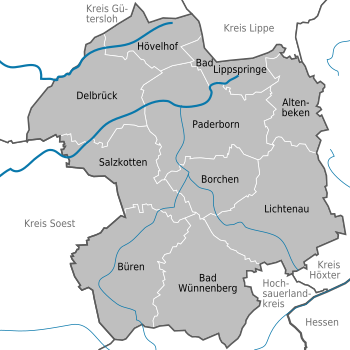
Circle structure
The Paderborn district is divided into ten municipalities, seven of which are cities . The district town of Paderborn is considered a large district city , Delbrück as a middle district city . The following table shows the municipalities of the district in alphabetical order with the number of inhabitants on December 31, 2019, the area and the population density:
| local community | Residents | km² | Inhabitant / km² |
  |
|---|---|---|---|---|
| Altenbeken | 9.113 | 76.17 | 120 | |
| Bad Lippspringe , city | 16,237 | 50.98 | 318 | |
| Bad Wünnenberg , city | 12,152 | 161.11 | 75 | |
| Borchen | 13,393 | 77.15 | 174 | |
| Büren , city | 21,515 | 170.91 | 126 | |
| Delbrück , city | 31,989 | 157.27 | 203 | |
| Hövelhof | 16,281 | 70.71 | 230 | |
| Lichtenau , city | 10,570 | 192.22 | 55 | |
| Paderborn , city | 151,633 | 179.38 | 845 | |
| Salzkotten , city | 24,956 | 109.53 | 228 |
Neighboring areas
The district borders in a clockwise direction in the northwest on the districts of Gütersloh , Lippe , Höxter , Hochsauerlandkreis and Soest .
history
The district was established as part of the North Rhine-Westphalian territorial reform in the course of the implementation of the "Law on the reorganization of the communities and districts of the Sauerland / Paderborn area ( Sauerland / Paderborn law )" of November 5, 1974 by merging the old Paderborn district with the Büren district formed with effect from January 1, 1975. Historically, it coincides with the Unterwald district of the former Hochstift Paderborn , in contrast to the Oberwald district , a forerunner of today 's Höxter district .
Population development
| year | Residents |
|---|---|
| 1975 | 213.018 |
| 1980 | 226.089 |
| 1985 | 230.070 |
| 1990 | 249.096 |
| 1995 | 278.020 |
| 2000 | 290,301 |
| 2005 | 298,703 |
| 2010 | 299,816 |
| 2015 | 304,332 |
politics
District Administrator

After the local elections in 2004, Manfred Müller of the CDU replaced the previous incumbent Rudolf Wansleben (CDU), who ran as an independent candidate in 1999 and won. Since October 1st, 2004 Manfred Müller has been the district administrator of the Paderborn district. In 2009 he was re-elected with 70.21% and in 2014 with 64.33% of the valid votes.
During the Prussian period (see Paderborn district (1816–1974) ):
- 1803–1830 Maximilian von Elverfeldt (1807–1813 as sub-prefect)
- 1831–1834 Adolph von Spiegel-Borlinghausen
- 1834–1842 Klemens von Wolff-Metternich
- 1842–1870 Franz Ludwig Grasso
- 1870–1875 Hugo von Brackel
- 1875–1903 Walther Jentzsch
- 1904–1934 Friedrich von Laer
During the Nazi era:
- 1934–1937 Friedrich Homann
- 1937–1945 Heinrich Althans
After 1945:
- 1946 Ferdinand Henkemeyer
- 1946–1948 Josef Büssemeier
- 1948–1963 Karl Rennkamp
- 1963/64 Johannes Ising
- 1964–1993 Joseph Köhler (appointed honorary district administrator)
- 1993–1999 Reinold pieces
- 1999-2004 Rudolf Wansleben
- since 2004 Manfred Müller
During this time, the following were senior district directors (administrative managers):
- 1945–1953 Wilhelm Gerbaulet
- 1953–1965 August Monzen
- 1965–1992 Werner Henke
- 1993–1999 Rudolf Wansleben (1999–2004 District Administrator)
District council
The district council was re-elected on May 25, 2014 . The 60 seats (previously 54 seats) are distributed as follows among the individual parties, each represented in parliamentary groups (for comparison the results of the last elections in 2009, 2004 and 1999):
| Election on Sept. 12, 1999 | Election on Sept. 26, 2004 | Election on Aug. 30, 2009 | Election on May 25, 2014 | |||||
|---|---|---|---|---|---|---|---|---|
| Political party | % | Seats | % | Seats | % | Seats | % | Seats |
| CDU | 61.7% | 33 | 59.41% | 32 | 52.59% | 28 | 51.85% | 31 |
| SPD | 23.4% | 13 | 21.10% | 11 | 18.33% | 10 | 21.41% | 13 |
| GREEN | 6.3% | 4th | 8.83% | 5 | 11.15% | 6th | 11.13% | 7th |
| FDP | 4.1% | 2 | 6.58% | 4th | 10.83% | 6th | 4.39% | 3 |
| THE LEFT. | - | - | - | - | 3.48% | 2 | 4.10% | 2 |
| AfD | - | - | - | - | - | - | 3.60% | 2 |
| FBI 1 | 4.4% | 2 | 4.08% | 2 | 3.61% | 2 | 1.86% | 1 |
| PIRATES | - | - | - | - | - | - | 1.21% | 1 |
| FWG Bad Lippspringe | - | - | - | - | - | - | 0.46% | - |
| graphic |  |
 |
 |
|||||
| total | 100.0% | 54 | 100.0% | 54 | 100.0% | 54 | 100.0% | 60 |
1 Free Citizens' Initiative
badges and flags
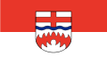
Description of coat of arms :
Under a silver (white) shield head divided by a blue wavy bar with a continuous red cross in silver (white) a red, seven-part diamond rafter.
Meaning:
The red cross in the head of the shield on a silver background symbolizes the affiliation to the former Paderborn monastery . The blue wave bar represents the abundance of water in the circle. The red, seven-part diamond chevron in the silver shield is the coat of arms of the noble lords of Büren , who ruled the southern district area in the Middle Ages .
Flag description:
The circle carries a flag with the colors red and white, it shows the coat of arms of the Paderborn district.

Coat of arms of today's Paderborn district

Coat of arms of the former district of Paderborn until 1974
Flag of the Paderborn district


District partnerships
There are district partnerships with the Berlin district of Tempelhof-Schöneberg , the Teltow-Fläming district in Brandenburg and the Mantua province in Italy . Also within the framework of the Franco-German treaty of 1963, the Paderborn district held annual youth encounters in France and Germany. Partnership-like relations have existed with the Israeli city of Naharya since the establishment of diplomatic relations between the two countries.
Economy and Infrastructure
In the Future Atlas 2016 , the Paderborn district was ranked 109th out of 402 districts, municipal associations and independent cities in Germany, making it one of the regions with good "future prospects".
traffic
Street
The Paderborn district has a well-developed road network with 4 federal highways and 2 federal highways. The main traffic line in the Paderborn district is the federal highway 33 , which, apart from a gap of 12 kilometers near Halle (Westphalia), connects the federal highway 30 in the north (Amsterdam-Bad Oeynhausen) with the federal highway 44 in the south (Aachen-Kassel). In December 2019, it should be passable between Osnabrück and Bad Wünnenberg . Until the completion of the gap in the Gütersloh district in 2019, the A 33 will already end at the Halle-Künsebeck junction. In the Paderborn district, around 49,000 vehicles are on the road every day on the A 33 in the section between Paderborn-Elsen and Paderborn-Zentrum. The BAB 33 replaces the federal road 68 as the main traffic axis in the Paderborn district. Until the mid-1980s, the B 68 was the main connection between Paderborn and Bielefeld . The Bundesautobahn 44 Dortmund-Kassel runs from the Geseke junction to the Blankenrode rest area through the Paderborn district. The A 44 between Kassel and the Ruhr area is one of the most important traffic axes in the east-west direction in Germany. Around 52,000 vehicles are on the road every day on the section in the Paderborn district between the Lichtenau junction and the Wünnenberg-Haaren motorway junction . The proportion of heavy goods traffic (truck traffic) is also remarkably high there, at almost 25% of the total volume of traffic.
railroad
The two long-distance train stations in the Paderborn district are in the city of Paderborn and Altenbeken . Since the substantial elimination of inter-regional connections in December 2002 is the Hauptbahnhof Paderborn also IC - stop on the Hamm-Warburg railway as part of the connection Dresden - Dusseldorf . In addition, Paderborn Central Station is a hub of the European integrated regular timetable . Regional trains from / to Kassel , Düsseldorf, Herford , Bielefeld , Göttingen , Holzminden , Münster and Hamm as well as the S5 of the Hanover S-Bahn stop or start and end in Paderborn . There are also train stations for regional traffic in Salzkotten and Hövelhof . In Paderborn there is a large repair shop for Deutsche Bahn freight wagons near the north station . In addition, the run (now dismantled, but not yet entwidmete) Alme Valley Railway (Paderborn-Brilon), the Senne-Bahn (Paderborn Bielefeld), the railway Altenbeken-Kreiensen , the railway line Hannover-Altenbeken , the railway Herford-Altenbeken and the only Occasional freight traffic used railway line Gütersloh-Hövelhof partly through the district area.
Airport
The Paderborn / Lippstadt airport complements the existing transport links to an international airport with regular flights , for example, the Star Alliance ( Lufthansa , Euro Wings etc.) to Munich, Frankfurt and Zurich, as well as tourist flights to various destinations in Europe.
License Plate
On July 1, 1956, the Paderborn district was assigned the distinctive symbol PB when the vehicle registration number that is still valid today was introduced . It is still issued today. Since November 24, 2014, the distinctive sign BÜR (Büren) has also been available.
literature
- District of Paderborn (Ed.): District of Paderborn - Festschrift for the inauguration of the district building in 1968 (printed by Bonifacius-Druckerei Paderborn 1968)
See also
Web links
- Paderborn district
- Paderborn district in the Westphalia Culture Atlas
Individual evidence
- ↑ Population of the municipalities of North Rhine-Westphalia on December 31, 2019 - update of the population based on the census of May 9, 2011. State Office for Information and Technology North Rhine-Westphalia (IT.NRW), accessed on June 17, 2020 . ( Help on this )
- ↑ Population of the municipalities of North Rhine-Westphalia on December 31, 2019 - update of the population based on the census of May 9, 2011. State Office for Information and Technology North Rhine-Westphalia (IT.NRW), accessed on June 17, 2020 . ( Help on this )
- ↑ Federal Statistical Office: Online research of the municipal directory ( memento of the original from October 9, 2014 in the Internet Archive ) Info: The archive link was automatically inserted and not yet checked. Please check the original and archive link according to the instructions and then remove this notice.
- ^ Federal Statistical Office (ed.): Historical municipality directory for the Federal Republic of Germany. Name, border and key number changes in municipalities, counties and administrative districts from May 27, 1970 to December 31, 1982 . W. Kohlhammer, Stuttgart / Mainz 1983, ISBN 3-17-003263-1 , p. 327 f .
- ^ State database North Rhine-Westphalia
- ↑ - ( Memento of the original from May 8, 2013 in the Internet Archive ) Info: The archive link was inserted automatically and has not yet been checked. Please check the original and archive link according to the instructions and then remove this notice.
- ↑ Future Atlas 2016. (No longer available online.) Archived from the original on October 2, 2017 ; accessed on March 23, 2018 . Info: The archive link was inserted automatically and has not yet been checked. Please check the original and archive link according to the instructions and then remove this notice.

Independent cities: Aachen | Bielefeld | Bochum | Bonn | Bottrop | Dortmund | Duisburg | Düsseldorf | Food | Gelsenkirchen | Hagen | Hamm | Herne | Cologne | Krefeld | Leverkusen | Mönchengladbach | Mülheim an der Ruhr | Munster | Oberhausen | Remscheid | Solingen | Wuppertal
Districts and city regions: City region Aachen | Borken district | Coesfeld district | District of Düren | Ennepe-Ruhr district | District of Euskirchen | District of Gütersloh | District of Heinsberg | Herford district | Hochsauerlandkreis | District of Höxter | District of Kleve | Circle lip | Märkischer Kreis | District of Mettmann | District of Minden-Lübbecke | Oberbergischer Kreis | District of Olpe | Paderborn district | Recklinghausen district | Rhein-Erft district | Rheinisch-Bergischer Kreis | Rhein-Kreis Neuss | Rhein-Sieg-Kreis | District of Siegen-Wittgenstein | District of Soest | District of Steinfurt | District of Unna | District of Viersen | District of Warendorf | Wesel district