
Oberbergischer Kreis
| coat of arms | Germany map |
|---|---|

|

Coordinates: 51 ° 1 ' N , 7 ° 31' E |
| Basic data | |
| State : | North Rhine-Westphalia |
| Administrative region : | Cologne |
| Regional association : | Rhineland |
| Administrative headquarters : | Gummersbach |
| Area : | 918.84 km 2 |
| Residents: | 272,057 (Dec. 31, 2019) |
| Population density : | 296 inhabitants per km 2 |
| License plate : | GM |
| Circle key : | 05 3 74 |
| NUTS : | DEA2A |
| Circle structure: | 13 municipalities |
| Address of the district administration: |
Moltkestrasse 42 51643 Gummersbach |
| Website : | |
| District Administrator : | Jochen Hagt ( CDU ) |
| Location of the Oberbergisches Kreis in North Rhine-Westphalia | |
  |
|
The Oberbergische Kreis is a district in the south of North Rhine-Westphalia . It is partly identical to the Oberbergisches Land region .
Geography, topography and nature
The Oberbergische Kreis lies in the east of the Bergisches Land nature park between the Rhine and Sauerland regions. It is 99.2 to 518.2 meters above sea level; the low mountain range is wooded, characterized by small-scale agriculture and has over 1400 villages and hamlets. Oberberg serves as a local recreation area for the neighboring metropolitan region of Rhine-Ruhr .
- Northernmost point: Bend of the Brebach , 480 meters northeast of the village of Griesensiepen / Spreel
- Southernmost point: tributary of the Holperbach, 660 meters west of Seifen (local community Forst , near Wissen / Sieg, district Altenkirchen )
- Most western point: Sülz , 200 meters west of Klefhaus and 90 meters above the confluence of the Dürschbach
- Easternmost point: 20 meters northwest of the L342, 790 meters east of Hardt
The highest natural elevation in the district is the Homert at 518 meters above sea level in the area of the city of Gummersbach on the eastern edge of the district, near the A 45 ; the lowest point is almost 100 meters above sea level on the Ehreshoven reservoir .
The Oberbergische Kreis has designated numerous nature reserves , the largest of which is the Wiehltalsperre with over 950 hectares. In addition to the nature reserves, there are also a number of natural monuments and landscape protection areas . The very water-rich region has 10 dams, which are not only fed by the largest rivers Agger , Wiehl and Wupper , but above all from the countless streams that run through the country.
In September 2016, the Oberberg Biological Station started the “Model Region Agriculture and Nature Conservation - Bergisches Land” project.
Neighboring districts and cities
Starting in the north in a clockwise direction, the district borders the Ennepe-Ruhr-Kreis (thus also the Ruhr Regional Association ), Märkischer Kreis and Olpe (all in North Rhine-Westphalia), and the Altenkirchen (Westerwald) district (in Rhineland- Pfalz ) as well as the Rhein-Sieg-Kreis , the Rheinisch-Bergisch Kreis and the independent cities of Remscheid and Wuppertal .
history
Oberberg is part of the Rhenish Slate Mountains and lies in the west of its part on the right bank of the Rhine. Its oldest history begins almost 400 million years ago as a tropical flat sea. It covered the area of the later Oberbergisches Land for more than 50 million years.
Compared to the Rhine lowlands, the Oberbergisch is not considered an "old settlement area". According to the interpretation of the names of the waters, Germanic immigrants from the north have settled the northern and central areas of the district since the older Latène period and the late Central European Iron Age . Germanic stream names in the catchment areas of the Wupper / Wipper, Agger and Wiehl bear witness to this. The main stream of settlers, who opened up the innerberg areas between the Ruhr and Sieg after centuries of largely empty settlements, came from the Rhine.
The existence of a royal court is documented in writing for the Oberbergisches. According to a document kept in the Düsseldorf main state archive, Emperor Friedrich I (HRR) transferred the " Curtis von Eckenhagen" with the silver pits and other "accessories" to the Archbishop of Cologne in 1167 . Since the municipal reform of 1969 - the communities of Denklingen and Eckenhagen were merged - the memory of the former belonging to the imperial or royal estate lives on in the new community name Reichshof.
Delimitation of the Bergisches Land from the Oberbergisches Land
The Oberbergisches Land is located in the south-east of the former Duchy of Berg, which was independent until 1614, and formerly adjacent areas and is now part of the Bergisches Land tourist region . As early as 1740, a description of the Duchy of Berg under the rule of the Palatinate-Neuburg family with its 17 offices separated the "Niederbergische" north of the Wupper from the "Oberbergische" south of it.
When the duchy and the neighboring territories were reorganized by Napoleon I in 1806 and by the Congress of Vienna in 1815, the previously independent imperial lords of Gimborn-Neustadt, to which Gummersbach belonged, and Homburg and parts of the county of Mark fell to the Grand Duchy of Berg and after 1815 to Prussia .
The Oberbergische Kreis from 1932 to 1974
The original Oberbergische Kreis was created in 1932 from the union of the Gummersbach and Waldbröl districts (without the Dattenfeld office ), with the district administration in Gummersbach. The name Agger-Wiehl-Kreis according to the rivers in the district was changed to Oberbergischer Kreis before it came into force . The name refers to the former sovereigns, the Counts of Berg .
The district included the two cities of Bergneustadt and Gummersbach as well as the communities of Denklingen , Drabenderhöhe , Eckenhagen , Gimborn , Lieberhausen , Marienberghausen , Marienheide , Morsbach , Nümbrecht , Ründeroth , Waldbröl and Wiehl . The municipality of Drabenderhöhe was renamed Bielstein (Rhineland) in 1960 .
In 1957, Waldbröl was the third municipality in the Oberbergischen to be granted city rights.
The law on the reorganization of the Oberbergisches Kreis reduced the number of municipalities in the district on July 1, 1969:
- Lieberhausen was divided between Gummersbach and Bergneustadt.
- Denklingen and Eckenhagen merged into the new Reichshof community .
- Marienberghausen and Nümbrecht were merged to form the municipality of Homburg , which was then renamed again to Nümbrecht.
- Bielstein and Wiehl were merged to form a new community Wiehl. In 1971 Wiehl was granted city rights
Thereafter, the four cities of Bergneustadt, Gummersbach, Waldbröl and Wiehl as well as the communities of Gimborn, Marienheide, Morsbach, Nümbrecht, Reichshof and Ründeroth belonged to the district until 1974.
The old Oberbergische Kreis last covered an area of 565.77 km².
The Oberbergische Kreis since 1975
The Oberbergische Kreis was formed in its current form on January 1, 1975 by the Cologne Act :
- Engelskirchen , Lindlar and Wipperfürth moved from the Rheinisch-Bergisches Kreis to the Oberbergischer Kreis.
- Ründeroth was for the most part incorporated into Engelskirchen and the remaining part to Wiehl.
- Gimborn was divided between Engelskirchen, Gummersbach, Lindlar and Marienheide.
- Hückeswagen and Radevormwald came from the dissolved Rhein-Wupper district to the Oberbergischer Kreis.
Population statistics
| year | Residents |
|---|---|
| 1933 | 79.105 |
| 1939 | 83,552 |
| 1950 | 121,369 |
| 1960 | 130,100 |
| 1970 | 148,300 |
| 1980 | 246.100 |
| 1990 | 263.276 |
| 2000 | 287.186 |
| 2010 | 280,840 |
| 2015 | 273,452 |
| 2019 | 272 320 |
Denomination statistics
According to the 2011 census , 83,581 (30.6%) of the population were Roman Catholic , 103,240 (37.8%) Protestant and 86,190 (31.6%) were non-denominational or belonged to another religious community. As of December 31, 2019, 78,200 (28.7%) of the 272,320 inhabitants were Roman Catholic.
politics
District council
Currently there is the following distribution of seats according to parliamentary groups in the district council (as of May 2014):
| CDU | SPD | GREEN | FDP / FWO / DU | THE LEFT | AfD | UWG | Non-attached | total |
|---|---|---|---|---|---|---|---|---|
| 25th | 16 | 5 | 4th | 3 | 2 | 2 | 1 | 58 |
| FDP 2 FWO / DU 1 |
DIE LINKE 2 PIRATES 1 |
per NRW 1 |
CDU, FDP and FWO / DU form a coalition which, together with the district administrator's vote, has 29 out of 59 votes.
District administrators
- 1932–1933: Gustav Haarmann (from 1911 to 1932 District Administrator of the Gummersbach district)
- 1933–1935: Gottfried Krummacher , NSDAP
- 1935–1945: Theodor Pichier , NSDAP
- 1945–1951: August Dresbach , CDU
- 1951–1952: Fritz Eschmann , SPD
- 1952–1956: Wilhelm Henn , CDU
- 1956–1961: Fritz Eschmann, SPD
- 1961–1964: Reinhard Kaufmann , CDU
- 1964–1969: Heinrich Schild , CDU
- 1969–1989: Hans Wichelhaus , CDU
- 1989–1994: Hans-Leo Kausemann , CDU
- 1994–1999: Herbert Heidtmann , SPD
Since October 1st, 1999 - as before 1945 - there is only one full-time district administrator who is also head of administration.
- 1999–2004: Hans-Leo Kausemann, CDU
- 2004–2015: Hagen Jobi , CDU
- 2015– : Jochen Hagt , CDU
Upper District Directors
- 1946–1979: Friedrich-Wilhelm Goldenbogen , CDU
- 1979–1987: Dieter Fuchs , CDU
- 1987–1994: Gert Ammermann , CDU
- 1995–1999: Heribert Rohr , SPD
economy
The economy in the district is mainly characterized by small and medium-sized industries. There are many companies in the plastics processing, auto parts, metal processing and services sectors.
Natural resources were mined until the 20th century. Numerous disused small outcrops and tunnels can be found in the entire district and some are designated as nature reserves, and there are still some large producing quarries in the Grauwacke . Agriculture and forestry shape the image of the landscape and its use.
The Oberbergischer Kreis plastics cluster has existed since 2005.
In 2014 the gross domestic product amounted to EUR 8.816 billion. (Eurostat) In comparison with the EU GDP, expressed in purchasing power standards, the Oberbergische Kreis achieved an index of 113.0 in 2014 (EU 28: 100 Germany: 125.0 NRW: 125.0)
The unemployment rate stood at 6.1% in May 2020.
In the future atlas 2019 , the district took 151st place out of 401 districts, municipal associations and independent cities in Germany and is therefore one of the regions with a “balanced risk-opportunity mix”.
Ties and holdings
The Oberbergische Kreis
- is a member of the German District Assembly
- is co-owner of the Kreissparkasse Köln
- belongs to the area of the Rhineland Regional Council
- is in the administrative district of Cologne
- is a member of the Regionale 2010 in the Cologne / Bonn region
- is co-owner of the Rhein-Sieg transport association .
Culture and sights
The so-called Bunte Kerken , the churches with medieval wall and ceiling paintings, are known nationwide. The Oberbergisches Land is also known for its mills and the numerous dams .
Other attractions are:
- Historic old town of Bergneustadt with a local museum
- Bergisches Freilichtmuseum Lindlar
- Oberbergischer Dom in Gummersbach
- Hülsenbusch Church (Protestant)
- Bergisches barrel organ museum (museum for mechanical musical instruments) in Marienheide-Kempershöhe
- Railway Museum Dieringhausen
- House Dahl
- Rhenish Industrial Museum in Engelskirchen
- Romanesque St. Nicholas Church in Wipperfürth
- Gimborn Castle
- Homburg Castle
- Castle and historic old town of Hückeswagen
- Wiehler stalactite cave
- Wiehltalbahn
- Panarbora Park
Jewish cemeteries
A Jewish cemetery is documented for the Oberbergischer Kreis , namely in Nümbrecht . It is a protected cultural monument - stone testimony to a formerly existing Jewish community and a lively Jewish community life up to the 1930s.
Regular events
Yearly
- 1st May and first weekend in May Medieval market at Homburg Castle in Nümbrecht
- May: International Wiehler Jazz Days
- First weekend in May: May fair in Ründeroth
- First weekend in May: Radevormwald city festival
- 1st and 2nd Pentecost: Pottery market in the historic castle courtyard of Reichshof-Denklingen
- Pentecost: Pentecost youth conference in Bergneustadt
- Whitsun: Shooting festival with a large fair in Bergneustadt
- First weekend after Pentecost: shooting festival on the Steinberg (Gummersbach)
- July: the first weekend of the shooting festival in Marienheide
- July: on the second weekend, the festival of lights in the spa gardens of Nümbrecht
- Summer: professional bike races with well-known riders in the center of Radevormwald
- August to October: Wiehler Dahlia Show
- September: Traditional plum fair in Radevormwald
- 2nd weekend in September: Old Town Festival in Hückeswagen
- Autumn: egg market in Eiershagen
- Autumn: Festival of Lights in Lindlar
- End of November: Christmas art market in Nümbrecht , last weekend before the 1st Advent
More often
- Every second Thursday cattle and grocery market in Waldbröl
- From March to December, the farmers and small animal market takes place on the first Sunday of the month at the Eckenhagen monkey and bird park .
Further
In addition, annual rifle and fire brigade festivals as well as numerous flea and Christmas markets take place throughout the district.
traffic
Road traffic
643 vehicles per 1,000 inhabitants are registered in the district (as of January 1, 2009) . This is the third highest vehicle density in North Rhine-Westphalia. For comparison: Germany has a total of 603 cars / 1,000 inhabitants.
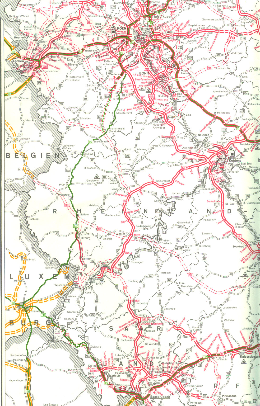
In the southern part of the Oberbergischer Kreis crosses Highway A 4 with connection points in Engelskirchen, Bielstein, Gummersbach, Reichshof / Bergneustadt and Reichshof-Eckenhagen the district area from west to east.
For a time, a federal motorway 451 was planned, which should run through the entire district from Waldbröl via Bergneustadt and Marienheide to Radevormwald. The section from Denklingen to Bergneustadt was largely completed with four lanes as the B 256 , a two-lane extension to Marienheide is still planned at a later date. The rest of the planning was discarded.
Furthermore, an A 54 in the north and an A 56 in the south should touch the district, the latter with a connection to the A 451. Both plans were rejected.
Transportation
In its railway network in the Oberbergisches Land, Deutsche Bahn maintains stops on the Oberbergische Bahn in Engelskirchen, Ründeroth, Dieringhausen, Gummersbach, Marienheide and Meinerzhagen, among others.
Other local transport lines are combined in the Oberbergische Verkehrsgesellschaft (OVAG) and other transport companies.
The Oberbergische Kreis belongs to the tariff area of the Verkehrsverbund Rhein-Sieg (VRS) .
Air traffic
There are two airfields for general aviation in the Oberbergischer Kreis . Both are now approved as special airfields.
There are also:
- Grounds for gliding in Lindlar and Radevormwald-Leye
- Free balloon launch sites in Reichshof-Eckenhagen, Nümbrecht and Wiehl
- Helicopter landing pads in Hückeswagen as well as at the district hospital Gummersbach and district hospital Waldbröl
The closest international airport is Cologne / Bonn Airport , around 20 km from the south-western border of the district.
Weather observation in the Oberbergischen
There are nine precipitation and climate stations of the German Weather Service in the district, namely at the Bevertalsperre near Wipperfürth, in Lindlar-Oberlichtinghagen, Marienheide-Kläranlage Nord, Morsbach, Radevormwald, Waldbröl and Wipperfürth-Gardeweg.
Since January 4th 2007 there is a weather station on the Lindchen in Nümbrecht. It is operated by Leif Kliesch and supplies the weather data to Jörg Kachelmann's measuring network.
The only online weather station of the German Weather Service in the district is located in Eckenhagen. There, air temperature and humidity, duration of sunshine and temperature in the ground are measured every ten minutes.
Since January 2006, the private weather station Bergneustadt has been recording current weather events. The hourly saved data are freely accessible from a weather archive. There is also a webcam archive with webcams from Bergneustadt and the surrounding area.
Communities
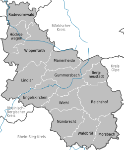  |


Cities
|
Other communities
|
(Population figures as of December 31, 2019)
License Plate
On July 1, 1956, the Oberbergischer Kreis was assigned the GM distinguishing mark , which stands for the district town of Gummersbach, when the license plates that are still valid today were introduced . It is still issued today.
See also
literature
- Mieke Brinkmann, Heinrich Müller-Miny: The Oberbergische Kreis . Bonn 1965.
- Klaus Goebel (Ed.): Oberbergische Geschichte , Vol. 1–3, Wiehl 1998–2001, Volume 1: From the beginnings to the Peace of Westphalia , author: Hellmut Grabert, Gero Karthaus, Günter Walzik, Albrecht Brendler, Wolfgang Herborn, Stefan Ehrenpreis, Gregor Horstkemper, Wiehl 2001, ISBN 3-88265-224-1 , Volume 2: From the Peace of Westphalia to the End of the Monarchy 1648–1918 , author: Gert Fischer, Volkmar Wittmütz, Dieter Lück, Wiehl 1998, ISBN 3 -88265-208-X , Volume 3: From the Weimar Republic to the turn of the millennium 1918–1999 , authors: Gerhard Pomykaj, Volker Dick, Wiehl 2001, ISBN 3-88265-225-X
- Richard Jilka (edit.): Bibliography on Oberbergischen history . 2nd edition, Gummersbach 1992.
- Oberbergische department of the Bergisches Geschichtsverein (ed.), Contributions to Oberbergische Geschichte , vol. 1ff., Gummersbach 1986ff.
- Herbert Nicke: The Oberbergisches Land. A landscape portrait . Wiehl 1995.
- Klaus Pampus: First documentary mentions of Oberbergischer places . Ed .: Oberberberg Department of the Bergisches Historisches Verein. Gronenberg, Gummersbach 1997, ISBN 3-88265-206-3 .
- HW Brandenburger: Ley-Land. Dr. Ley and National Socialism in the Oberbergischen . Cologne 1988.
- Harry Böseke: The Oberbergisches Land. History - culture - leisure . Avlos-Verlag , Sankt Augustin 1995, ISBN 3-929634-14-7 .
- Heinz Mühlenweg: From Wilhelm II to Konrad I. How our Bucklige Welt did the first half of the XX. Century experienced - suffered - survived. A contribution to the local history of Oberberg . Self-published, Gummersbach 1983.
- Gero Karthaus : Nature on the doorstep - life with landscape, plants and animals in Oberberg villages then and now . ISBN 3-88913-148-4 .
- Klaus Goebel, Gerhard Pomykaj: An uncomfortable democrat, August Dresbach on his 100th birthday . Gummersbach 1994, ISBN 3-88265-192-X
- Gerhard Pomykaj (ed.): Everyday life from a medical point of view. The Gummersbach district in 1825 as reflected in two medical topographies . Gummersbach 1988, ISBN 3-88265-152-0 .
- Gero Karthaus : A strong piece of home - Oberberg villages . Bergisch Gladbach, 2008, ISBN 978-3-87314-436-1
Web links
Individual evidence
- ↑ Population of the municipalities of North Rhine-Westphalia on December 31, 2019 - update of the population based on the census of May 9, 2011. State Office for Information and Technology North Rhine-Westphalia (IT.NRW), accessed on June 17, 2020 . ( Help on this )
- ↑ obk.de
- ↑ obk.de
- ↑ obk.de (PDF)
- ↑ biostationoberberg.de
- ↑ Heimatverein Bielstein: On the history of Bielstein ( Memento of the original from October 7, 2014 in the Internet Archive ) Info: The archive link was inserted automatically and has not yet been checked. Please check the original and archive link according to the instructions and then remove this notice.
- ↑ Statistical Yearbook for the Federal Republic of Germany 1975
- ↑ a b c d Michael Rademacher: German administrative history from the unification of the empire in 1871 to the reunification in 1990. oberbergkreis.html. (Online material for the dissertation, Osnabrück 2006).
- ↑ Statistical Yearbook for the Federal Republic of Germany 1972
- ↑ Statistical Yearbook for the Federal Republic of Germany 1981
- ↑ a b Brief portrait - The Oberbergische Kreis ( Memento of the original from November 29, 2014 in the Internet Archive ) Info: The archive link has been inserted automatically and has not yet been checked. Please check the original and archive link according to the instructions and then remove this notice.
- ↑ State Office for Statistics NRW
- ↑ obk.de statistics Oberbergischer Kreis
- ↑ obk.de statistics Oberbergischer Kreis
- ↑ Oberbergischer Kreis Religion -in%, 2011 census
- ↑ Statistics: The Archdiocese of Cologne in Figures , accessed on June 30, 2020.
- ↑ election results.nrw.de
- ↑ Composition of the district council
- ↑ kreistags-spd.de
- ↑ appsso.eurostat.ec.europa.eu Statistics by NUTS 3 regions
- ↑ appsso.eurostat.ec.europa.eu Statistics by NUTS 3 regions
- ↑ statistik.arbeitsagentur.de Statistics of the Federal Employment Agency
- ↑ Future Atlas 2016. (No longer available online.) Prognos , June 15, 2016, archived from the original on October 2, 2017 ; accessed on March 26, 2018 . Info: The archive link was inserted automatically and has not yet been checked. Please check the original and archive link according to the instructions and then remove this notice.
- ^ Claudia Pohl: Jewish cemeteries according to the current administrative structure: Oberbergischer Kreis . In: Peter Honigmann (Hrsg.): Jüdische Friedhöfe in Deutschland: Overview of all Jewish cemeteries in the area of the Federal Republic of Germany with special consideration of the inscription documentation . Central archive for research into the history of Jews in Germany: Collections: Friedhofsdokumentation, Heidelberg, December 2002 version, accessed on August 4, 2017.
- ^ The circle in numbers in: Kölner Stadt-Anzeiger, October 28, 2009, p. 40
- ^ Map with motorway plans (part 09) from January 1, 1976 from autobahn-online.de
- ↑ Bergneustadt weather and webcam archive
- ↑ Population of the municipalities of North Rhine-Westphalia on December 31, 2019 - update of the population based on the census of May 9, 2011. State Office for Information and Technology North Rhine-Westphalia (IT.NRW), accessed on June 17, 2020 . ( Help on this )

Independent cities: Aachen | Bielefeld | Bochum | Bonn | Bottrop | Dortmund | Duisburg | Düsseldorf | Food | Gelsenkirchen | Hagen | Hamm | Herne | Cologne | Krefeld | Leverkusen | Mönchengladbach | Mülheim an der Ruhr | Munster | Oberhausen | Remscheid | Solingen | Wuppertal
Districts and city regions: City region Aachen | Borken district | Coesfeld district | District of Düren | Ennepe-Ruhr district | District of Euskirchen | District of Gütersloh | District of Heinsberg | Herford district | Hochsauerlandkreis | District of Höxter | District of Kleve | Circle lip | Märkischer Kreis | District of Mettmann | District of Minden-Lübbecke | Oberbergischer Kreis | District of Olpe | Paderborn district | Recklinghausen district | Rhein-Erft district | Rheinisch-Bergischer Kreis | Rhein-Kreis Neuss | Rhein-Sieg-Kreis | District of Siegen-Wittgenstein | District of Soest | District of Steinfurt | District of Unna | District of Viersen | District of Warendorf | Wesel district