
Altenkirchen district (Westerwald)
| coat of arms | Germany map |
|---|---|

|

Coordinates: 50 ° 45 ' N , 7 ° 44' E |
| Basic data | |
| State : | Rhineland-Palatinate |
| Administrative headquarters : | Altenkirchen (Westerwald) |
| Area : | 641.99 km 2 |
| Residents: | 128,805 (Dec. 31, 2019) |
| Population density : | 201 inhabitants per km 2 |
| License plate : | AK |
| Circle key : | 07 1 32 |
| Circle structure: | 119 parishes |
| Address of the district administration: |
Parkstrasse 1 57610 Altenkirchen (Westerwald) |
| Website : | |
| District Administrator : | Peter Enders ( CDU ) |
| Location of the district of Altenkirchen (Westerwald) in Rhineland-Palatinate | |
  |
|
The district of Altenkirchen (Westerwald) is a regional authority in northern Rhineland-Palatinate and lies between the metropolitan regions of Rhine-Ruhr and Rhine-Main . The seat of the district administration is the eponymous city of Altenkirchen (Westerwald) , the most populous city is Betzdorf .
geography
The area of the district of Altenkirchen (Westerwald) is 642 square kilometers.
location
The Altenkirchen district is the northernmost district in Rhineland-Palatinate. It includes the northern part of the Westerwald and the southwestern part of the Siegerland (so-called upper district). The Wildenburgische Land, named after the county of Wildenburg, lies north of the Sieg . Other rivers in the district are the Wied and the Nister .
Neighboring areas
The district borders clockwise to the west, beginning with the Rhein-Sieg district , the Oberbergischer district , the district Olpe and the district Siegen-Wittgenstein (all in North Rhine-Westphalia ) as well as the Westerwaldkreis and the district Neuwied (both in Rhineland-Palatinate ).
history
The current district area belonged to different domains before 1803, u. a. the counties Sayn-Altenkirchen and Sayn-Hachenburg , the rule Wildenburg (already extinct in 1418, their possessions later came to the princes of Hatzfeld ) and the electorates of Cologne and Trier . All areas became Prussian in 1815. The state of Prussia divided its provinces into administrative districts and districts. This is how the Altenkirchen district in the Coblenz administrative district came into being in 1816 . The Prussian administration divided the district into the mayor offices of Altenkirchen , Daaden, Flammersfeld , Friesenhagen, Gebhardshain, Hamm, Kirchen, Weyerbusch and Wissen. The former lordships of Wildenburg and Schönstein were elevated to civil status in 1821 , but were again subordinated to the district administrator of Altenkirchen in 1839. The mayor's offices were renamed to offices in 1927 and existed until 1968. The association communities emerged from them . The name "Kreis Altenkirchen" was changed to "Landkreis Altenkirchen" in 1938, and the name "Kreis Altenkirchen" is still frequently used today. In March / April 1945, after the capture of the Remagen Bridge , American units fought here with the Wehrmacht .
The boundaries of the district have only changed insignificantly in the course of history. So on November 7, 1970, the municipality of Berod near Hachenburg was reclassified from the Oberwesterwaldkreis . On the same day, the Heckenhahn district of the Rott community was reclassified to the Neuwied district .
The Altenkirchen district has been part of the Rhineland-Palatinate state since 1946 .
Population statistics
As of December 31, 2019, the Altenkirchen (Westerwald) district had 128,805 inhabitants. The population density on the reference date was 201 inhabitants per square kilometer. At the end of 2013 there were more women (50.7 percent) than men (49.3 percent) in the district. At 34.9 percent, the old-age quotient exceeds the youth quotient (31.9 percent).
The proportion of foreigners (registered residents without German citizenship ) was 5.1 percent on December 31, 2013 (6,609 people). The most strongly represented nationalities are mainly residents from Turkey, Poland, Italy, Kosovo, Russia, Greece, Serbia, Romania, the Netherlands and Spain.
In March 2015, the district recorded an unemployment rate of 5.5 percent (3,791 people).
.svg)
The development of the number of inhabitants in relation to today's area of the Altenkirchen district, the values from 1871 to 1987 are based on censuses. From 1990 onwards, the status of December 31st is listed, based on the sole or main residence:
|
|
|
Denomination statistics
According to the 2011 census , 34.0% of the population in 2011 were Protestant , 42.1% were mostly Roman Catholic and 23.8% were non-denominational , belonged to another religious community or did not provide any information. The number of Protestants and Catholics has fallen since then. Currently (as of May 31, 2020) of the 129,777 inhabitants, 30.4% are Protestant, 37.3% are predominantly Roman Catholic and 32.3% are non-denominational or belong to another religious community.
politics
District council
The district council of the district of Altenkirchen (Westerwald) consists of 46 district council members, who were elected in a personalized proportional representation in the local elections on May 26, 2019 , and the district administrator as chairman.
| Parties and constituencies | % 2019 |
Seats 2019 |
% 2014 |
Seats 2014 |
% 2009 |
Seats 2009 |
% 2004 |
Seats 2004 |
% 1999 |
Seats 1999 |
|
|---|---|---|---|---|---|---|---|---|---|---|---|
| CDU | Christian Democratic Union of Germany | 35.2 | 16 | 42.9 | 20th | 42.4 | 19th | 51.3 | 24 | 49.8 | 24 |
| SPD | Social Democratic Party of Germany | 25.0 | 11 | 33.9 | 15th | 30.1 | 14th | 29.2 | 13 | 35.9 | 16 |
| FWG | District Association of Free Voting Groups | 8.1 | 4th | 7.5 | 3 | 7.6 | 3 | 7.7 | 3 | 6.0 | 2 |
| GREEN | Alliance 90 / The Greens | 13.0 | 6th | 6.9 | 3 | 6.4 | 3 | 5.8 | 3 | 4.1 | 2 |
| FDP | Free Democratic Party | 6.5 | 3 | 3.9 | 2 | 9.9 | 5 | 5.9 | 3 | 4.3 | 2 |
| THE LEFT. | THE LEFT. | 3.5 | 2 | 3.7 | 2 | 3.6 | 2 | - | - | - | - |
| PIRATES | Pirate Party Germany | - | - | 1.2 | 1 | - | - | - | - | - | - |
| AfD | Alternative for Germany | 8.6 | 4th | - | - | - | - | - | - | - | - |
| total | 100.0 | 46 | 100.0 | 46 | 100.0 | 46 | 100.0 | 46 | 100.0 | 46 | |
| Turnout in percent | 59.5 | 56.8 | 53.4 | 55.8 | 62.6 | ||||||
District administrators
- 1816–1844 Wilhelm Richard Phillip Koch (1775–1848)
- 1845–1851 Franz Jacob von Hilgers (1810–1891)
- 1851–1852 Adolf Ernst von Ernsthausen (1827–1894)
- 1852–1875 Heinrich Joseph Kampers (1806–1886)
- 1876–1882 Johannes Kiesel
- 1882–1902 Friedrich Boehm (1834–1906)
- 1902–1912 Robert von Görschen (1864–1936)
- 1912–1919 Clemens Busch (1879–1966)
- 1919–1933 Wilhelm Boden (1890–1961)
- 1933–1938 Konrad Gorges (1898–1968)
- 1938–1945 Ernst Ewald Kunckel (1902–1970)
- 1945–1945 Wilhelm Boden, second term of office
- 1945–1948 Richard Bornheim
- 1948–1966 Hanns Sinzig (1901–1992)
- 1966–1979 Hermann Krämer (1919–2006)
- 1980–1988 Alfred Beth (* 1940)
- 1989–1998 Herbert B. Blank (1947–1998)
- 1998–2006 Alfred Beth, second term of office
- 2006–2019 Michael Lieber (* 1953)
- since 2019 Peter Enders (* 1959)
Peter Enders (CDU) was elected in direct election on May 26, 2019 with a share of the vote of 54.9% and took office on September 1, 2019.
Landtag and Bundestag
- The district of Altenkirchen is divided into the state electoral districts of Betzdorf / Kirchen (Sieg) and Altenkirchen (Westerwald) . In the state elections in 2011, Josef Rosenbauer ( CDU ) and Peter Enders (CDU) were directly elected to the state parliament. Thorsten Wehner ( SPD ) and Anne Neuhof ( Greens ) received seats in the Rhineland-Palatinate state parliament from the Altenkirchen district .
- Together with the Neuwied district, the Altenkirchen district is part of the Neuwied federal electoral district . In the 2013 federal election , Erwin Rüddel (CDU) was directly elected to the Bundestag. Sabine Bätzing-Lichtenthäler (SPD) was elected from the constituency above the list .
badges and flags
Hoist flag


The district of Altenkirchen (Westerwald) has a coat of arms and a flag.
|
|
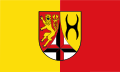
Blazon : "Split by a curved silver tip, inside a continuous cross, cut in black and red, in front a double-tailed, blue-armored lion, in front in red, an upright black wall anchor in gold." |
| Justification of the coat of arms: The lion stands for the County of Sayn, the wall anchor for the Lords of Wildenburg and the two-colored cross for the two electoral principalities of Cologne (black) and Trier (red). The coat of arms was approved on December 11, 1967. |
traffic
The federal motorway 3 Frankfurt – Cologne runs through the district in the extreme southwest with the Neuwied / Altenkirchen exit in Willroth. A 45 Gießen – Dortmund is located a little to the east of the district . Since the end of 2016, the district has been connected to the Siegen junction by the Hüttentalstrasse , which ends in Mudersbach- Niedererschelderhütte . In the north, leads A 4 Cologne-Olpe over. The district is otherwise crossed by numerous federal highways, including the B 8 , B 62 and B 256 .
As early as 1860, the Cöln-Mindener Eisenbahn-Gesellschaft ran its railway line from Cologne in the Siegtal up to Wissen and a year later to Siegen ( Siegbahn ). Since 1861 the main line has branched off as the Hellertalbahn from Betzdorf via Herdorf towards Haiger – Dillenburg .
A quarter of a century later the Prussian State Railway opened up the side valleys and the high Westerwald : The Limburg railways reached the district town of Altenkirchen in 1884 via Siershahn ( Unterwesterwaldbahn / Holzbachtalbahn) and in 1885 via Hachenburg ( Oberwesterwaldbahn ); the connection to the route in the Siegtal near Au followed in 1887.
A branch line was opened from Betzdorf to Daaden in 1885/86, the cross connection from Kirchen to Freudenberg followed in 1887/88 , later to Olpe (1907) and in 1890 the Wissertal Railway from Wissen to Morsbach was added. Finally, the Kasbachtalbahn from Linz am Rhein in Flammersfeld was connected to the Siershahn – Altenkirchen line .
The Gebhard Hainer country opened up the circle old churches themselves through the opened in 1913 and later repeatedly extended "district light railway Scheuerfeld-Nauroth" , as Altenkirchen Westerwaldbahn the circle GmbH today is and the traffic on the state railway Betzdorf - Daaden (Daadetalbahn) and Hellertalbahn has taken over.
The Free Grunder Railway, which today belongs to KSW Kreisbahn Siegen-Wittgenstein GmbH, began in Herdorf in 1907/08 .
Passenger traffic was stopped on several branch lines with a total length of 78 km between 1945 and 1984:
- 1945: Morsbach - Wisserhof - Wissen 6 km, Neustadt - Peterslahr - Flammersfeld 10 km, Weitefeld - Emmerzhausen - Lippe airfield , 13 km
- 1950: Herdorf Nbf. - Salchendorf - Wilden , 1 km ( Free Grunder Railway )
- 1950/51: Bindweide - Rosenheim - Nauroth, 5 km
- 1957: Elkenroth - Weitefeld, 3 km
- 1960: Scheuerfeld - Bindweide - Elkenroth, 14 km (gradual closure of the original Westerwaldbahn; freight traffic to Weitefeld)
- 1983: Olpe - Oberasdorf - Wehbach - Kirchen, 12 km (south of the Asdorftalbahn )
- 1984: Siershahn - Flammersfeld - Altenkirchen, 14 km (central section of the Engers-Au railway line )
63 km remained for passenger traffic, i.e. less than half of the previous network.
Since August 1, 2002, the tariff of the Verkehrsverbund Rhein-Sieg (VRS) has been used as a transitional tariff on all rail routes in the Altenkirchen district if the start or destination station is in the area of the VRS. From the municipalities of Wissen, Betzdorf, Daaden and Kirchen as well as from the city of Herdorf, journeys at the Westphalian tariff to selected cities in the Siegen-Wittgenstein district are possible on the rail routes and on individual bus routes ; From the VG Kirchen, journeys via Freudenberg to the Olpe district are also permitted. On January 1, 2009, the Altenkirchen district joined the Rhein-Mosel transport association (VRM). For trips within the district boundaries and, for example, also to the neighboring district of Neuwied , its ticket prices have been valid since then.
Association and local congregations
The district of Altenkirchen (Westerwald) comprises 119 local communities , which are part of seven association communities . The largest town is Betzdorf with 10,064 inhabitants, the smallest municipality is Eulenberg with 48 inhabitants. The following lists the municipalities with their local municipalities and cities as well as the number of inhabitants as of December 31, 2019. (The administrative offices of the municipalities are marked with an asterisk. They are listed alphabetically according to the municipalities.)


The following municipalities in the district have lost their independence to this day:
|
|
Several parishes have been renamed:
- Birch fractures was on August 1, 1978 Birch Honigsessen renamed.
- Blickhauserhöhe was renamed Mittelhof on March 1, 1986 .
- Kirchen-Wehbach (Sieg) was renamed Kirchen (Sieg) on June 7, 1969 .
- Kotzenroth was renamed Rosenheim (Altenkirchen district) in 1963 .
- Niederingelbach was renamed Ingelbach in 1950 .
- Nochen was renamed Katzwinkel (Sieg) on July 1, 1970 .
For lists on the term "area changes" see area reforms in Rhineland-Palatinate .
Emergency numbers
In the district of Altenkirchen (Westerwald), new emergency numbers have been in effect in some cases since November 1, 2008. The police emergency number 110 has remained unchanged and is still used by the police in Betzdorf, Altenkirchen (Westerwald), Straßenhaus , Siegen or Gummersbach . There were changes to the emergency number 112. It is now switched to the integrated rescue control center in Montabaur . All fire brigades as well as the emergency doctors and ambulances in the district are alerted from here. The obsolete service number 19222 from the German Red Cross has had its day.
Sons and daughters of the circle
- Friedrich Wilhelm Raiffeisen (born March 30, 1818 in Hamm (Sieg) ; † March 11, 1888 in Heddesdorf ), social reformer (founder of the Raiffeisen banks)
- Joseph Höffner (born December 24, 1906 in Horhausen ; † October 16, 1987 in Cologne), social and economic ethicist, Bishop of Münster, Archbishop of Cologne, cardinal, chairman of the German Bishops' Conference
License Plate
On July 1, 1956, the district was assigned the distinctive sign AK when the vehicle registration number that is still valid today was introduced . It is still issued today.
See also
Literature (selection)
- Iris Benner: cultural landscape Altenkirchen. A journey to art and nature. Altenkirchen 2006, ISBN 3-00-018481-3 .
- Margot Bitterauf-Remy: The art monuments of the Altenkirchen district. Düsseldorf 1935.
- Matthias Dahlhoff: History of the County of Sayn. Dillenburg 1874.
- Manfred Hermanns : The social and economic spatial structure of the Altenkirchen district. Diss. Phil. the Westf. Wilhelms-Universität Münster (Westf.). 1964.
- Manfred Hermanns: District of Altenkirchen (Westerwald) (= Institute for Regional Studies [Hrsg.]: The districts in Rhineland-Palatinate . Volume 6 ). Altenkirchen (Westerwald) 1969 (with 32 maps, 7 illustrations and 28 plates).
- Heinrich Holschbach: Folklore of the Altenkirchen district. Elberfeld 1928.
- Erwin Katzwinkel and Franz-Eugen Volz: Small bibliography of the Altenkirchen district (Westerwald). Altenkirchen district (publisher), Altenkirchen 1978.
- Josef Klein: The economic development of the Altenkirchen district since the beginning of the 19th century. Knowledge 1926.
- Hermann Krämer (Ed.): The district of Altenkirchen. Oldenburg 1972.
- District administration Altenkirchen (Ed.): Land to Sieg and Wied. Local history of the Altenkirchen district. Knowledge 1987.
- District administration Altenkirchen (Ed.): The district Altenkirchen in the 20th century. A chronicle. Altenkirchen 1992, ISBN 3-925190-10-4 .
- Peter Lindlein: 200 years of the Altenkirchen district. Photographs by Peter Lindlein. With photos by Peter Weller , August Sander and Bernd and Hilla Becher . Frankfurt 2016, ISBN 978-3-9817020-1-9 .
- Jakob Rausch: History of the Altenkirchen district. Reprint of the 1921 edition, Schaan / Liechtenstein 1983.
- Daniel Schneider: The history of the local community Obererbach (Westerwald). The villages of Hacksen, Niedererbach, Obererbach and Koberstein from the Middle Ages to the present. 2 volumes, Obererbach 2009, ISBN 978-3-00-027494-7 (with a summary of the development of the Altenkirchen district).
- Martin Sinemus: The history of the Protestant parishes of the parish of Altenkirchen (Westerwald). Saarbrücken 1933.
Web links
- Website of the district of Altenkirchen (Westerwald)
- Statistical data for the district of Altenkirchen (Westerwald) from the State Statistical Office of Rhineland-Palatinate
- Literature from and about the district of Altenkirchen in the catalog of the German National Library
- Literature on the district of Altenkirchen in the Rhineland-Palatinate state bibliography
Individual evidence
- ↑ a b State Statistical Office of Rhineland-Palatinate - population status 2019, districts, municipalities, association communities ( help on this ).
- ↑ a b c d My district, my independent city - Altenkirchen district (Westerwald). State Statistical Office of Rhineland-Palatinate, accessed on April 28, 2015 .
- ↑ The end of the war at home ( Memento from July 31, 2012 in the web archive archive.today )
- ↑ Official municipality directory (= State Statistical Office of Rhineland-Palatinate [Hrsg.]: Statistical volumes . Volume 407 ). Bad Ems February 2016, p. 147 (PDF; 2.8 MB).
- ↑ Reporting month March 2015 - Altenkirchen (Westerwald). Central statistics service of the Federal Employment Agency , accessed on April 28, 2015 .
- ↑ District Altenkirchen Religion , 2011 census
- ↑ Altenkirchen district statistics , accessed on June 15, 2020
- ↑ What is a weighted result? (No longer available online.) The State Returning Officer Rhineland-Palatinate, archived from the original on October 2, 2011 ; Retrieved April 28, 2015 .
- ↑ The election supervisor: Announcement of the results of the election of the district administrator of the Altenkirchen district on May 26, 2019 (PDF) June 3, 2019, accessed on December 2, 2019 .
- ↑ State Statistical Office of Rhineland-Palatinate - population status 2019, districts, communities, association communities ( help on this ).
Districts:
Ahrweiler |
Altenkirchen (Westerwald) |
Alzey-Worms |
Bad Dürkheim |
Bad Kreuznach |
Bernkastel-Wittlich |
Birkenfeld |
Cochem cell |
Donnersbergkreis |
Eifelkreis Bitburg-Prüm |
Germersheim |
Kaiserslautern |
Kusel |
Mainz-Bingen |
Mayen-Koblenz |
Neuwied |
Rhine-Hunsrück District |
Rhein-Lahn district |
Rhine-Palatinate District |
Southern Wine Route |
Southwest Palatinate |
Trier-Saarburg |
Vulkaneifel |
Westerwaldkreis
Independent cities:
Frankenthal (Pfalz) |
Kaiserslautern |
Koblenz |
Landau in the Palatinate |
Ludwigshafen am Rhein |
Mainz |
Neustadt an der Weinstrasse |
Pirmasens |
Speyer |
Trier |
Worms |
Zweibrücken