
Churchib
| coat of arms | Germany map | |
|---|---|---|

|
Coordinates: 50 ° 43 ' N , 7 ° 27' E |
|
| Basic data | ||
| State : | Rhineland-Palatinate | |
| County : | Altenkirchen (Westerwald) | |
| Association municipality : | Altenkirchen-Flammersfeld | |
| Height : | 312 m above sea level NHN | |
| Area : | 6.55 km 2 | |
| Residents: | 516 (Dec. 31, 2019) | |
| Population density : | 79 inhabitants per km 2 | |
| Postal code : | 57635 | |
| Area code : | 02683 | |
| License plate : | AK | |
| Community key : | 07 1 32 062 | |
| Community structure: | 8 districts | |
| Association administration address: | Rathausstrasse 13 57610 Altenkirchen (Westerwald) |
|
| Website : | ||
| Local Mayor : | Lothar Bellersheim | |
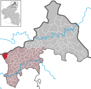
| Location of the parish of Kircheib in the district of Altenkirchen (Westerwald) | ||
  |
||


Kircheib is a municipality in the district of Altenkirchen (Westerwald) in Rhineland-Palatinate . It belongs to the community of Altenkirchen-Flammersfeld .
geography
Kircheib is a street village on Bundesstraße 8 between Hennef (Sieg) and Altenkirchen . It lies on the edge of the Leuscheid , a forest area in northern Rhineland-Palatinate. The so-called "Altenkirchen-Asbacher plateau" makes up a large part of the approximately 600 hectare large area, which serves as a resting place for migratory birds in spring and autumn.
In addition to the eponymous place, the community also includes the districts Bleckhausen, Eckenbach, Grünewald, Neuenhof, Reisbitzen, Röttgen and Tente.
Not far from the village, on Dreiherrenstein, runs the border of the (rural) districts Altenkirchen , Neuwied and Rhein-Sieg .
history
Probably the first documentary mention as Eipe (also Eype ) dates from 1268. A small Romanesque basilica and remains of a so-called Motte ( Broichhausen ), a medieval fortress, have been preserved from the same period . Below Kircheibs near Vierwinds the old county of Sayn-Altenkirchen bordered the Duchy of Berg and the Electorate of Cologne . The four winds border point was marked by the "Dreiherrenstein", which was rebuilt a few years ago. In earlier times three Landwehr met here , the Bergische , the Koln and the Sayniche ; The old military forces that used to reach the fortified church still bear witness to this. The Saynic Landwehr moved across the Eyper Heide at the heights of Bleckhausen via Neuenhof to the Mehrbachtal . Extensive remnants of late medieval ramparts in the area of the so-called Kircheiber Heide (nature reserve) on the border with North Rhine-Westphalia (in the Lindscheider grove on today's district boundary) complete the historical features of the place on a watershed between Sieg and Wied .
In 1796 the village was involved in the battle of Kircheib between the French under General Kléber and the Austrians under General Kray . The bayonet fight raged on the "Köppchen" east of Kircheib, where today the road climbs in a short attempt to the large forest of the Leuscheider ridge.
Kircheib belonged to the County of Sayn-Altenkirchen until the beginning of the 19th century , from 1803/06 to the Duchy of Nassau and from 1815 to the Kingdom of Prussia . After the administrative structure that was newly formed at the time, the localities of today's local community belonged to the Weyerbusch mayor's office in the Altenkirchen district and the Koblenz administrative district . Kircheib with the towns of Eckenbach, Grünewald, Bleckhausen and Reisbitzen and Neuenhof with the towns of Burg, Röttgen and Tente were two independent communities. 1931 Kircheib got its own post office Class II in the district of the post office Asbach.
Count Friedrich III was probably born in Neuenhof in 1618 . von Wied , who founded the town of Neuwied in 1653 .
- Population development
The development of the population of Kircheib, the values from 1871 to 1987 are based on censuses:
|
|
politics
Municipal council
The council in Kircheib consists of twelve council members, who in the local elections on May 26, 2019 in a majority vote were elected, and the honorary mayor as chairman.
mayor
Lothar Bellersheim became mayor of Kircheib on July 9, 2019. In the direct election on May 26, 2019, he was elected for five years with 90.08% of the vote. Bellersheim is the successor to Karl-Heinz Sterzenbach.
coat of arms
|
|
Blazon : "Divided by silver over red and split at the top by a blue wave pole, in front a single-tower, day-lit, black church western structure, behind a red bar, below a growing, blue-tongued and armored golden leoparded lion." |
|
Justification for the coat of arms: The wave pile symbolizes the Eipbach. The front field with a black silhouette represents the church tower of Kircheib. The red bar symbolizes the coat of arms of the noblemen of Ütgenbach . In the red base of the shield you can see a golden Saynic lion with a blue tongue, blue claws and a double tail. The color of the church tower silhouette corresponds to the Kurkölner cross.
The coat of arms was developed in collaboration with local history researchers Horst Weiß, Buchholz and Jost Hausmann ( State Main Archives Koblenz ) and approved on February 9, 2010. |


Culture and sights
Attractions
- The Evangelical Parish Church in Kircheib is a Romanesque three-aisled basilica with a chancel covered by a groin vault. Renovation and restoration of the basilica shape by architect Ludwig Hofmann in 1902. The origins of the church with the striking defensive tower date back to the 12th century. During the Reformation, the church became Protestant. In 1589 it appears as a branch of Mehren . It was separated from there in 1879 and subordinated to the Protestant community of Asbach (Neuwied district), to which it still belongs today.
- In the church there is an old Romanesque font from the beginning of the 13th century.
- At Kircheib, a memorial commemorates the former three-man stone Meisenbach .
societies
- Pentecost Club Churchib
- Backesverein
Economy and Infrastructure
In the tradition as a historic market town on Bundesstraße 8 , the main income of the residents is still characterized by trade and handicraft. With a population of only about 500 church members, more than 30 small and large businesses have settled here.

literature
- Local community Kircheib (ed.): Kircheib - in pictures and documents. A Chronicle , 1st edition, Kircheib 1993.
- Hanna Hoffmann: Kircheib and his Romanesque church , in: Heimat-Jahrbuch des Kreis Altenkirchen (Westerwald) 32 (1989), pp. 65–71.
- Hans Lahr: Own local coat of arms for Kircheib , in: Heimat-Jahrbuch des Kreis Altenkirchen (Westerwald) 54 (2011), p. 70.
- Daniel Schneider: The development of denominations in the county of Sayn in the ground plan , in: Heimat-Jahrbuch des Kreis Altenkirchen (Westerwald) 58 (2015), pp. 74-80.
Web links
- Page of the website of the local parish Kircheib
- Local parish Kircheib on the website of the Verbandsgemeinde Altenkirchen
- Brief portrait of Kircheib at SWR
Individual evidence
- ↑ a b State Statistical Office of Rhineland-Palatinate - population status 2019, districts, municipalities, association communities ( help on this ).
- ↑ State Statistical Office Rhineland-Palatinate (ed.): Official directory of the municipalities and parts of the municipality. Status: January 2018 [ Version 2020 is available. ] . S. 8 (PDF; 2.2 MB).
- ↑ cit. after: Hanna Hoffmann: Kircheib and his Romanesque church
- ^ Theo Winterscheid: From the history of the post in the Windhagener area. In: Windhagen - Ein Heimatbuch , Economica Verlag, Bonn 1994, p. 113.
- ↑ State Statistical Office Rhineland-Palatinate - regional data
- ^ The Regional Returning Officer Rhineland-Palatinate: Municipal Council Election 2019 Kircheib. Retrieved December 26, 2019 .
- ↑ Mitteilungsblatt Verbandsgemeinde Altenkirchen: From the constituent meeting of the local community council on July 9, 2019. Linus Wittich Medien GmbH, edition 36/2019, accessed on December 26, 2019 .
- ^ The Regional Returning Officer of Rhineland-Palatinate: direct elections 2019. see Altenkirchen-Flammersfeld, Verbandsgemeinde, 33rd line of results. Retrieved December 26, 2019 .
- ^ Hans Lahr: Own local coat of arms for church ib. In: Heimat-Jahrbuch des Kreis Altenkirchen (Westerwald) 2011. P. 70.
- ↑ On denominational development cf. Daniel Schneider: The development of denominations in the county of Sayn in the plan, pp. 74-80.
- ↑ Extensive information on the further development of the place can be found in a chronicle that was written on the occasion of the 725th anniversary in 1990 by Peter Krah, Frances de Schrevel and others.

Almersbach | Alsdorf | Altenkirchen (Westerwald) (city, seat of the district administration) | Bachenberg | Berod near Hachenburg | Berzhausen | Betzdorf (city) | Birch honey meal | Birch bump | Birnbach | Bitches | Brachbach | Breitscheidt | Bruchertseifen | Bürdenbach | Burglahr | Busenhausen | Daaden (city) | That | Dickendorf | Eichelhardt | Oak trees | Elves | Elkenroth | Emmerzhausen | Ersfeld | Etzbach | Eulenberg | Fensdorf | Fiersbach | Flammersfeld | Floodlight | Forest | Forstmehren | Friedewald | Friesenhagen | Fürthen | Gebhardshain | Gieleroth | Giershausen | Grünebach | Güllesheim | Hamm (victory) | Harbach | Hasselbach | Helmenzen | Helmeroth | Hemmelzen | Herdorf (city) | Haylofts | Hilgenroth | Hirz-Maulsbach | Horhausen (Westerwald) | Hövels | Idelberg | Ingelbach | Isert | Katzwinkel (victory) | Chew | Kescheid | Kettenhausen | Churchib | Churches (victory) (city) | Kraam | Krunkel | Malberg | Mammelzen | Mauden | More | Michelbach (Westerwald) | Mittelhof | Molzhain | Mudersbach | Nauroth | Neitersen | Niederdreisbach | Niederfischbach | Niederirsen | Niedersteinebach | Nisterberg | Obererbach (Westerwald) | Oberirsen | Oberlahr | Obernau | Obersteinebach | Oberwambach | Oils | Orfgen | Peterslahr | Pleckhausen | Splendor | Racksen | Reiferscheid | Rescuers | Rosenheim (District of Altenkirchen) | Roth | Rott | Scheuerfeld | Schöneberg | Stokes | Schutzbach | Seelbach (Westerwald) | Seelbach near Hamm (victory) | Soaps | Selbach (victory) | Sörth | Steinebach / Victory | Steineroth | Stürzelbach | Volkerzen | Wallmenroth | Walterschen | Weitefeld | Werkhausen | Weyerbusch | Willroth | Knowledge (city) | Wölmersen | Goat grove