Eipbach
| Eipbach | ||
|
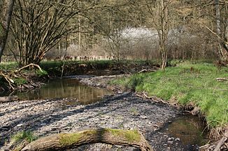
The Eipbach in the middle course |
||
| Data | ||
| Water code | DE : 27258 | |
| location | North Rhine-Westphalia , Germany | |
| River system | Rhine | |
| Drain over | Victory → Rhine → North Sea | |
| source | West of Kircheib 50 ° 42 ′ 43 ″ N , 7 ° 26 ′ 32 ″ E |
|
| Source height | approx. 270 m above sea level NHN | |
| muzzle | In Eitorf in the Sieg coordinates: 50 ° 46 ′ 37 ″ N , 7 ° 26 ′ 39 ″ E 50 ° 46 ′ 37 ″ N , 7 ° 26 ′ 39 ″ E |
|
| Mouth height | 83 m above sea level NHN | |
| Height difference | approx. 187 m | |
| Bottom slope | approx. 19 ‰ | |
| length | 10.1 km | |
| Catchment area | 23.782 km² | |
| Left tributaries | Birnbach or Eitorfer Bach (left upper course), Scheidsbach | |
| Right tributaries | Wohmbach (right upper course), Linkenbacher Bach, Rüsenbach, Pingelsbach | |
|
In Eitorf the Eipbach is canalised. |
||
|
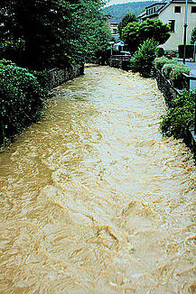
The Eipbach at the same point during the flood in 2007 |
||
The Eipbach is a 10.1 km long tributary of the Sieg , which flows into it from the left in the eponymous town of Eitorf in the North Rhine-Westphalian Rhein-Sieg district .
geography
course
The Eipbach arises a little west of Kircheib under the name Birnbach or Eitorfer Bach in Rhineland-Palatinate. He very quickly enters the area of the municipality of Eitorf , which he crosses in a somewhat winding valley northwards. Immediately after the national border, it receives its largest tributary near Obereip, the Wohmbach from the east from the Natura 2000 protected area Wohmbach and tributaries , which are located in the wooded Leuscheid ridge . In terms of length and catchment area, this inflow clearly exceeds the Birnbach , which is officially part of the main stream , so it is, hydrologically, the actual upper course; thereafter the stream is only called Eipbach .
In the further course the inflow from the right continues to dominate, in particular through the Linkenbacher Bach at the end of Mühleip and the Pingelsbach already in the upper village of Eitorf. There the lower course was relocated to the west, while it used to flow east of the Brückenstraße, today it reaches the Sieg almost a kilometer further downstream only west of this road.
The national road 86 runs from the country border to Eitorf by the Birnbach- and Eipbachtal.
Catchment area
The 23.782 km² catchment area , largely located in the municipality of Eitorf , includes Kircheib (Rhineland-Palatinate), the localities of Eitorfer Schweiz and the following localities in the Eiptal and the side valleys:
- Obereip, a chapel since 1735
- Schellberg
- Obereiper mill
- Millip
- Hausen
- Scheidsbach
- Mierscheid
- Welterode Castle
- and Eitorf.
The latter, like the -eip -locations, also got its name from the Eipbach, it was previously called Eypdorf . The name Eip itself comes from Ap and is of Celtic origin. It stands for running water.
The Pingelsbach flows into the upper village of Eitorf, part of which catches the localities
- Kasberg
- Lax oath
- Seventh red and
- Rosenthal
included in whole or in part.
Inflow system
- Birnbach or Eitorfer Bach, left and shorter upper course
- Kircheiber Bach, from the right on the edge of Obereip
- Wohmbach, right and longer upper course
- Hedge depths, from the right
- Junkerbuschsiefen, from the right
- Köhlerssiefen, from the right
- Irscheider Bach, from the left
- Irscheider Siefen, from the left
- Königssiefen, from the left
- Suck (t?) Erothbach, from the left
- Tieferbach, from the right to the Obereiper mill
- Mutterbach, from the left at the beginning of Mühleip
- Gießenbach or Giesenbach, from the left in Mühleip
- Linkenbacher Bach, from the right to Mühleip
- Keuenhofer Bach, from the right at Keuenhof
- Suckersbach, from the left through Keuenhof
- Keuenhofer Bach, from the right at Keuenhof
- Scheidsbach, from the left near Scheidsbach
- Mühlengraben, from the right in the estuary
- Rüsenbach, from the right at the beginning of Eitorf
- Pingelsbach, maybe also Dehlenbach, from the right in the upper village of Eitorf
- Lascheider Bach, from the left before entering the village to Eitorf
- Pfaffensiefen, from the left near Bachgasse in Eitorf
Originally Eipbach flowed east of the Brückenstraße into the Sieg, today more than half a kilometer further down west of the road.
Retention basin
On the upper reaches of the Eipbach near Mühleip and Obereiper Mühle there are two retention basins and a third under the Place du Bouchain , all of which were built due to the catastrophic floods of 1970 when the entire town center was under water.
fauna
A species-rich fauna can be found on the Eipbach. Black woodpeckers , kingfisher , dipper , white wagtail and mountain wagtail and also the black stork are native here, as well as the yellow-bellied toad .


