Millip
|
Millip
Eitorf municipality
Coordinates: 50 ° 43 ′ 52 ″ N , 7 ° 27 ′ 5 ″ E
|
|
|---|---|
| Height : | approx. 180–220 m above sea level NHN |
| Residents : | 1468 (2014) |
| Postal code : | 53783 |
| Area code : | 02243 |
|
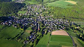
Mühleip, aerial photo (2017)
|
|
Mühleip is the largest suburb of the municipality of Eitorf in the North Rhine-Westphalian Rhein-Sieg district . The place name is based on an old mill on the Eipbach .
Mühleip has its own parish, elementary school, kindergarten and its own diverse club life. Linkenbach belongs to the present day place and today only one street name reminds of it. Linkenbach used to be the main town, which was also the center of its own honor .
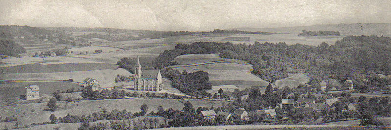
The Church of St. Aloysius was built in 1894.
location
Mühleip is located in the middle of the Eipbach valley. To the east are the villages of Eitorfer Schweiz , to the west of Lindscheid . To the south lies Obereip with the Obereiper mill .
Residents
In 1885 Mühleip had 38 residential buildings and 176 residents.
Individual evidence
- ↑ Eitorf municipality, accessed on February 24, 2014 ( Memento from November 9, 2017 in the Internet Archive )
- ^ Hermann Josef Ersfeld: Eitorfer Bild-Chronik, a contribution to the local history 1850-1950. Self-published, Eitorf 1980.
- ^ Community encyclopedia for the Kingdom of Prussia . Volume XII. Rhineland Province. Publishing house of the Royal Statistical Bureau, Berlin 1888, p. 115 ( online [PDF; 1.5 MB ; accessed on December 17, 2015]).
Mühleip, located in the valley, with the church of St. Aloysius around 1900. To the left of the church is the settlement of Linkenbach. The building on the far left is the former pastorate (now privately owned).


