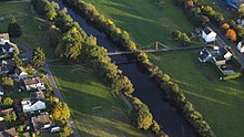
Halter ferry

The holy house of Saint Apollonia on the halter ferry was mentioned as early as 1729.
Halfterfähre was part of the municipality of Eitorf and is now part of Alzenbach . It was named after a former ferry service to the village of Halft on the opposite bank. Today a hanging walkway connects both sides.
location
Halter ferry is located on the south, left bank of the Sieg .
Residents
In 1885 Halfterfähre had a residential building with eight residents.
Individual evidence
- ^ Community encyclopedia for the Kingdom of Prussia . Volume XII. Rhineland Province. Publishing house of the Royal Statistical Bureau, Berlin 1888, p. 115 ( online [PDF; 1.5 MB ; accessed on December 17, 2015]).
Coordinates: 50 ° 46 ' N , 7 ° 29' E

