Dreiherrenstein Meisenbach

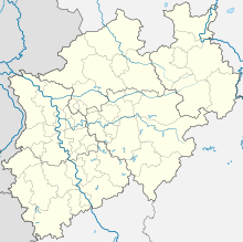
Coordinates: 50 ° 42 ′ 42.42 " N , 7 ° 26 ′ 20.52" E
In Meisenbach formerly stood Dreiherrenstein as a boundary mark between the Duchy of Berg , of Sayn and the Electorate of Cologne . A memorial commemorates the boundary stone that has since been destroyed .
history
The Hohe Strasse , also Frankfurter Strasse , from Cologne to Frankfurt am Main was a historic trade route . Today it is part of the federal highway 8 from Elten to Passau and thus part of the European trade route from Antwerp to Constantinople .
Control over trade routes was in the interests of the neighboring territorial rulers, as taxes and duties could be levied there.
In the 14th century, the Duchy of Berg, the County of Sayn and the Electorate of Cologne developed into competing neighbors on Frankfurter Strasse, especially in the Uckerath area to Kircheib . Customs agreements were concluded, customs offices were set up, and land forces were set up as security systems. The sovereigns tried to change the imprecise border lines in their favor.
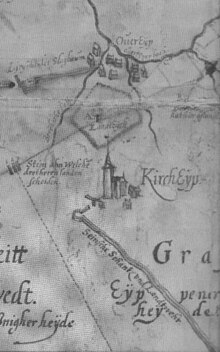
Presumably around 1600, three boundary stones were set in the prominent source basin of the Krabach on the Asbach plateau near Meisenbach to determine the meeting of the three territories . The map by Jordan van der Wayen from 1607 notes: Stein ahn which / three gentlemen land / part . Since then, the three stones mark the controversial border point of the territories of the Duchy of Berg, County of Sayn and the Electorate of Cologne.
However, the border disputes continued. The Electorate of Cologne expanded its economic interests in the 18th century, paved part of the road as a stone path in the disputed border area and increased road tolls . Presumably the three boundary stones were destroyed. The Duchy of Berg held back and replaced the destroyed stones with the three-man stone in 1766 .
After the Napoleonic Wars , the Congress of Vienna in 1815 made the entire area part of Prussia as the Rhine Province . There were no more national borders here. In the years 1825/26 the cadastral system was introduced and the land boundaries were essentially determined according to the ideas of the Electorate of Cologne. It was three-men-stone replaced by an ordinary landmark.
After the Second World War , the state reorganization took place in 1945. The location of the former three-man stone regained importance. The districts of Altenkirchen and Neuwied in the Koblenz administrative district belonged to the French occupation zone . The Rhein-Sieg district in the administrative district of Cologne belonged to the British zone . The British-French zone boundary in 1946 with the founding of the countries of North Rhine-Westphalia and Rhineland-Palatinate the international border .
monument
To commemorate the striking border point Drei-Herren-Stein , at which three territories collided in the Middle Ages and today the borders of two federal states , two administrative districts , three districts and four municipalities meet, the Westerwald-Verein Buchholz e. V. erected a memorial in 1989; it stands at an altitude of 263.7 m above sea level. NN . For the installation site of the basalt boulder on the historic square, a parcel of land was assigned by the owner. The inscription reads:
According to / a / map / by Jordan / van der Waye / from 1607 / stood / at this point / three stones. / The note on / this card / reads: / Stein ahn which / three gentlemen land / part: / These were the territories / Duchy of Berg / County of Sayn / Electorate of Cologne: / Today this / point divides the federal states / North Rhine- Westphalia / Rhineland-Palatinate / the administrative districts / Cologne + Koblenz / the Altenkirchen / Neuwied + Rhein-Sieg district / the municipalities of Buchholz / Hennef Eitorf Kircheib / established in 1989 / Westerwald-Verein / Buchholz eV / Heimatverein Eitorf eV / Bürgergemeinschaft / Uckerath / and the communities
Current maps show the exact boundary lines. North of the state border are the state of North Rhine-Westphalia, the administrative district of Cologne and the Rhein-Sieg district. The town of Hennef is to the northwest and the municipality of Eitorf to the northeast . The state of Rhineland-Palatinate and the administrative district of Koblenz are south of the state border. To the southwest lie the Neuwied district and the Buchholz community . To the southeast are the district of Altenkirchen and the community of Kircheib .
Individual evidence
- ↑ Map service of the landscape information system of the Rhineland-Palatinate nature conservation administration (LANIS map) ( notes )
- ↑ North Rhine-Westphalian Main State Archive Düsseldorf, Map III, No. 145 / 102a
- ↑ http://www.westerwaldverein-buchholz.de/
- ↑ Topographical Information Management, Cologne District Government, Department GEObasis NRW ( Notes )
literature
- Fischer, Helmut: The three men’s stone, to which three men will part - History of a border mark , published by Stadt Hennef (Sieg) - Lower Monument Authority, Hennef, 1989.

