Trade route

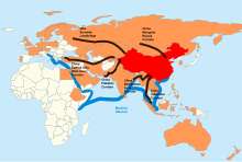
" One Belt, One Road " (OBOR) project.
Red: People's Republic of China ,
Orange: members of the AIIB
A trade route (also "trade route ") is a transport route for trade goods . Trade routes are part of economic geography , some have existed since time immemorial and have been significant not only for regional trade ( -> " old roads " ) , especially since ancient times . In the Middle Ages ( 11th to 12th centuries ) there was e.g. B. in the northern hemisphere an extensive and distinct network of trade routes from the east coast of China to England , Ireland , Scandinavia , Spain , to the west coast of north and east coast of Africa , to the Siberian Sea as to India and Indonesia , etc.
The international , partly inter- continental networks are a foundation for the globalization of the economy . They are and were the basis for exchange , encounters, diffusion and migration between people , nations , words and languages , peoples and cultures , religions and worldviews , for the exchange of political and scientific ideas , knowledge and attitudes as well as the pathways for diseases and development Animal and plant species . Their crossings over State - and other area boundaries are and were occasions for border - and customs stations to the collection of applicable fees as "entrance fee". In addition, road tolls were and are levied as a "passing fee", which - also known as toll - is used to build and maintain the road . The organization of the transport is summarized under " Logistics ".
Trade routes by mode of transport
The modern project One Belt, One Road (OBOR, Chinese 一帶 一路 / 一带 一路 , Pinyin Yídài Yílù - "One Band, One Road", colloquially also Belt and Road Initiative (B&R) or New Silk Road ( 新 絲綢之路 / 新丝绸之路 , Xīn Sīchóuzhīlù ) or Silk Road Economic Belt (" Silk Road Economic Belt ", 絲綢之路 經濟 帶 / 丝绸之路 经济 带 , Sīchóuzhīlù Jīngjìdài )) has been bundling the Chinese goals for the development of a cross- continent and transport mode since 2013 Infrastructure trade and transport network between China and other countries in Asia as well as Europe and some countries in Africa .
Airways
Airways here means flight routes of cargo planes .
Streets
"Trade route" means land route for land vehicles such as carts , trucks , freight trains , etc., the focus of the concept is to "trade" and says nothing about the quality and state of development of the used routes are decisive awareness, frequency of use and naming. As a rule, trade routes were unpaved roads , in the Roman Empire they were partly built with roughly hewn stones into traffic routes ( -> Roman road , Via Appia ) that are comparable to today's roads. The routes mostly followed the watershed , either on the respective mountain or hill crest or parallel to the slope. If a lane was left, one drove next to it or shifted the lane sideways by a few to hundreds of meters so that old streets often look like meandering rivers when viewed from above . The (goods) traffic was mostly carried out with beasts of burden or with wooden wagons that were hauled by draft animals (mostly oxen , since horses were too expensive). The mule tracks that were set up in impassable mountainous landscapes are also considered to be trade routes . Water hazards were often overcome in fords . Under appropriate climatic conditions or seasons, ice-covered waters also become trade routes.
Since the medieval trade routes were all unpaved ( nature trails ), the vehicles often had broken wheels and axles. According to the customary law of the time , all goods that fell on the ground became the property of the respective manor . Broken wheels and axles were a good source of income. The teamsters therefore had always spare wheels and axles there. Nobody was interested in maintaining or even expanding the paths. Some landlords are even said to have prepared the paths accordingly so that the trading wagons overturned.
At intersections, bridges, fords or in oases , the roots for the establishment of cities or settlements can often be found. Infrastructure and supply facilities for the transporters also played an important role in the network of trade routes: These include unloading of the draft and pack animals, caravanserais (in the Orient), inns, road houses and later post stations . They offered safe overnight accommodation, the supply of food and drink, short rest from exertion and opportunities to change and nourish the train and mount animals.
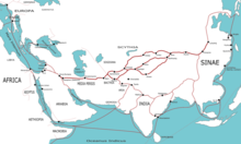
The world's longest and perhaps best-known trade route is u. U. the silk road . In Europe , the later paved country roads emerged from the trade routes . In Germany, almost all single-digit numbers on federal highways roughly follow important old trade routes, e.g. B. the federal highway 1 on a section of the Westphalian Hellweg and the federal highway 2 almost completely the Via Imperii .
Examples


blue: routes to Byzantium
red: Volga trade route
orange: further trade routes

- Altstrasse
- Amber Road (since prehistoric times various routes for the amber trade from the Baltic / North Sea to the Alpine countries)
- Bhor Ghat
- Burgunderstrasse
- Chilkoot Pass
- Dalton Trail
- Djungarian gate , valley plain and mountain pass on the border between East Kazakhstan and Northwest China
- Golden path
- Grand Trunk Road (has linked Peshawar with Dhaka for centuries)
- Haines Highway
- Hellweg
- Kaltag Portage
- Caravan roads
- New Eurasian Continental Bridge
- Ochsenweg (also "Heerweg", on the Cimbrian peninsula, between Germany (Hamburg / Elbe) and Denmark (Viborg), during the Bronze Age)
- Old Spanish Trail
- Reichsstrasse (Middle Ages)
- Salt caravans in the Sahara
- Salt road (noun)
- Santa Fe Trail
- Silk Road (between East Asia and the Mediterranean, originated around the 5th century BC)
- Silk Road Economic Belt (" Silk Road Economic Belt ")
- Tea Road (trade route for tea from China to today's Russia)
-
Tea route (for the trade in various teas from China and neighboring areas, here in particular the
- Tea Horse Road (Chinese tea <-> Tibetan horses)
- Trans-Asian Railway
- Trans-Eurasia-Express
- Trans-Kalahari-Highway ("Iron Silk Road")
- Via Engadina
- Via Imperii
- Via Publica
- Via Regia
- Frankincense Route (between Egypt and Arabia as well as India, established around the 18th century BC)
To water
Waterways are routes traveled by watercraft on inland waterways . A. to name all major rivers or the streams of all continents, e.g. B. Amazon , Elbe , Congo , Nile , Mississippi , Rhine , Volga , etc., also in detail z. B .:
Sea routes
Seewege means here with z. B. cargo ships used trade routes on seas , z. B .:
- Maritime Silk Road ("Maritime Silk Road")
- Around the polar ice cap of the Arctic at the North Pole : Northwest Passage , Northeast Passage
- Sea route to India (see also India trade )
See also
Web links
Individual evidence
- ^ A Fascinating Map of Medieval Trade Routes. Retrieved May 27, 2018 (American English).
- ^ Nick Routley: Mapping the Spread of Words Along Trade Routes. April 5, 2019, Retrieved May 30, 2019 (American English).
- ↑ Asia House Foundation, giga-hamburg.de: Old Silk Road in a new guise - China's globalization offensive (PDF, accessed on May 14, 2017)


