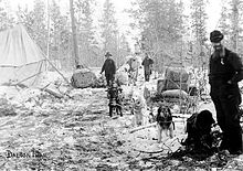
Dalton Trail
The Dalton Trail was a trade route in Canada that originated between a Tlingit tribe on the coast and an Athabaska tribe in the interior and was expanded by white settlers from around 1892. It connected the coast west of Haines at Pyramid Harbor with the Fort Selkirk trading post in the Yukon Territory and was used by gold prospectors during the time of the gold rush in Alaska and made known with it.
The length of the path varies between 246 and 305 miles (about 400 to 490 kilometers); there were apparently different routes at different times. What all routes had in common, however, was the use of the Chilkat Pass with a height of 1070 m to cross a mountain range between the Klehini River and Kelsall River .
The trail was originally named after the main commercial product, the oil of the candle fish , as Grease trail , but shortly before 1900 prospectors after Jack Dalton (1855-1944), an adventurer from present-day Kansas, who explored the area from 1891 and renamed Around 1896 the trade path, which was in very poor condition up to this point, was expanded from Pyramid Harbor to the foot of the Chilkat Pass over a length of 60 miles (about 110 kilometers), made usable for pack horses and partly for carts and several rest stops erected. One of them was named after him as the Dalton Post . A census on October 4, 1898 found a population of 3 white settlers and more than 100 members of the Stick people living in the area for this post .
With the expansion of the path through Dalton, the Tlingit's trade monopoly was broken. The path lost its importance as early as 1900 after the neighboring White Pass and Yukon Railway was completed.
Today the trail can partly be used as a hiking route; other parts, especially in the area of the Chilikat Pass , are used by the Haines Highway .
