Klehini River
| Klehini River | ||
|
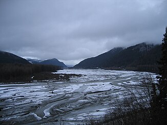
The Klehini River near the Haines Highway |
||
| Data | ||
| Water code | US : 1423105 | |
| location |
British Columbia ( Canada ), Alaska ( USA ) |
|
| River system | Chilkat River | |
| Drain over | Chilkat River → Pacific Ocean | |
| source | 5 km south of Nadahini Mountain 59 ° 37 '4 " N , 136 ° 39' 50" W |
|
| Source height | approx. 1500 m | |
| muzzle | in the Chilkat River coordinates: 59 ° 24 '40 " N , 135 ° 55' 51" W 59 ° 24 '40 " N , 135 ° 55' 51" W. |
|
| Mouth height | 34 m | |
| Height difference | approx. 1466 m | |
| Bottom slope | approx. 25 ‰ | |
| length | 58 km | |
The Klehini River is a glacier-fed river in the Stikine region in the north of the Canadian province of British Columbia and in the panhandle of the US state of Alaska , northwest of Haines .
The Klehini River is 58 long and has its source in British Columbia near the Alaska border. It flows into the lower reaches of the Chilkat River , of which it is the largest tributary , near Wells in the Alaska Chilkat Bald Eagle Preserve . The mouth of the Tsirku River is 2 km further south. The Haines Highway runs parallel to the river from the state line to the confluence of the Klehini River and the Chilkat River. The Klehini River forms the northern limit of the Chilkat Range , a mountain range of the Alsek Ranges in the Elias chain .
Web links
- Klehini River . In: BC Geographical Names (English)
- Map of the Klehini River, Alaska Department of Natural Resources (PDF file, 3 MB)
