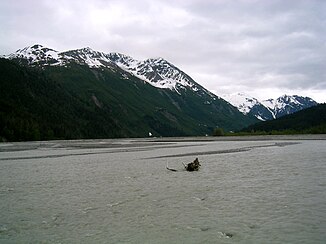
Tsirku River
| Tsirku River | ||
|
The Tsirku River west of the river delta |
||
| Data | ||
| Water code | US : 1415434 | |
| location | Alaska ( USA ) | |
| River system | Chilkat River | |
| Drain over | Chilkat River → Pacific Ocean | |
| origin |
Tsirku Glacier 59 ° 17 ′ 53 ″ N , 136 ° 25 ′ 5 ″ W |
|
| Source height | 606 m | |
| muzzle | in the Chilkat River coordinates: 59 ° 22 ′ 40 " N , 135 ° 51 ′ 30" W 59 ° 22 ′ 40 " N , 135 ° 51 ′ 30" W |
|
| Mouth height | 17 m | |
| Height difference | 589 m | |
| Bottom slope | 15 ‰ | |
| length | 40 km | |
The Tsirku River is a glacier-fed right tributary of the Chilkat River in the Panhandle of the US state Alaska , northwest of Haines .
It has its source on the Tsirku Glacier on the border between Alaska and British Columbia , but runs entirely on US soil. The Tsirku flows into the Chilkat River in the Alaska Chilkat Bald Eagle Preserve near the Tlingit village of Klukwan in an alluvial cone several kilometers wide . It is the second largest tributary of the Chilkat after the Klehini River .
Web links
- Map of the Tsirku River, Alaska Department of Natural Resources (PDF file, 3 MB)
