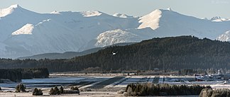
Chilkat Range
| Chilkat Range | ||
|---|---|---|
|
Juneau International Airport in front of the Chilkat Range |
||
| Highest peak | Mount Young ( 1737 m ) | |
| location | Alaska (USA) | |
| part of | Alsek Ranges | |
|
|
||
| Coordinates | 58 ° 45 ′ N , 135 ° 30 ′ W | |
The Chilkat Range is a 40 km long mountain range of the Alsek Ranges west of Juneau in Alaska .
The Chilkat Range is on the border between Haines Borough and Glacier Bay National Park and separates Chilkoot Inlet and Lynn Canal from Muir Inlet and Glacier Bay . In the north it extends to the Klehini River and in the south to the Icy Strait . An unnamed ice field feeds the Davidson and Rainbow glaciers, among others .
The highest mountains are Mount Young with 1737 m and Mount Case with 1676 m .
The United States Geological Survey gave the mountain range the name Chilkat Mountains in 1879 based on a tribe of the Tlingit Indians . In 1891 the name was changed to Chilkat Range .
Web links
Commons : Chilkat Range - Collection of Images, Videos and Audio Files
- Chilkat Range on Peakbagger.com (English)
- Chilkat Range in the Geographic Names Information System of the United States Geological Survey


