Chilkoot Pass
| Chilkoot Pass | |||
|---|---|---|---|
|
Gold prospector trek on the Golden Stairs at the Chilkoot Pass in the winter of 1897–98 |
|||
| Compass direction | southwest | Northeast | |
| Pass height | 1067 m | ||
| region | Skagway Borough , Alaska ( USA ) Alaska , United States | Stikine Region , British Columbia ( Canada ) British Columbia , Canada | |
| Watershed | Taiya | Yukon | |
| Valley locations | Dyea | Bennett | |
| expansion | Chilkoot Trail | ||
| Mountains | Boundary ranges | ||
| particularities | National Historic Place (USA) National Historic Site (Canada) |
||
| profile | |||
| map | |||
|
|
|||
| Coordinates | 59 ° 41 '46 " N , 135 ° 14' 10" W | ||
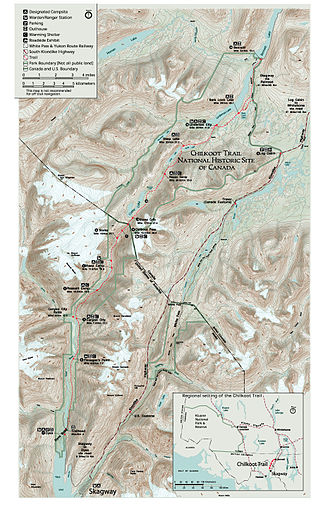
The Chilkoot Pass is a 1067 m high mountain pass in the Boundary Ranges of the Coast Mountains on the border between Alaska and British Columbia, Canada, and is part of the Klondike Gold Rush National Historical Park .
The path over the Chilkoot Pass was a trade route for the Athapaska and Na-Dené Indians, who traded seafood and furs here for centuries. "Chilkoot" is a modification of "Chilkat", the name of a group of the Tlingit . It was not until the 1870s that George Holt became the first member of a non- indigenous people to cross the pass. On May 28, 1882, the Berlin teacher Arthur Krause was followed by the first research traveler .

During the Klondike gold rush at the end of the 19th century, prospectors from the port town of Skagway on the Inside Passage had to cross either the White or the Chilkoot Pass in order to be able to travel on from Lake Bennett by boat on the Yukon River . The ascent to the pass begins in Dyea , 7.5 miles west of Skagway, and ends after 33 miles in Bennett on Lake Bennett. Dyea, now an orphaned village of which hardly anything still exists, had a population of 8,000 in 1898 when the gold rush peaked.
Over 100,000 people crossed the Chilkoot Pass between 1897 and 1899. At the Canadian border at the height of the pass, the prospectors had to be able to show equipment and provisions for one year in order to be allowed to pass. Minimum requirements were u. a. 500 pounds of flour, 100 pounds of sugar, and various other foodstuffs and utensils such as B. 500 candles. In total, the weight of the equipment required, which had to be transported over the pass in several stages, amounted to almost a ton . To transport the complete equipment over the 53 km from Dyea to Bennett, 3000 km had to be covered. Less than half of the 100,000 prospectors made it to the Klondike. Jack London describes the route via the chilkoot in his book Alaska-Kid .
After Dyea, the trail winds its way along the Taiya River before it leaves the canyon, climbs to the tree line and after a good 20 km reaches the Golden Stairs , where a height difference of 305 m has to be overcome over a distance of 800 m (see photo ) to get to the pass.
During the gold rush, several cable cars and freight elevators were in operation for a short time. With the opening of the White Pass and Yukon Railway over the neighboring White Pass, the use of the Chilkoot Pass was discontinued.
On April 14, 1975, the trail was added to the US National Register of Historic Places . On November 20, 1987, the trail was declared a National Historic Site of Canada .
literature
- Archie Satterfield: Chilkoot Pass, the Most Famous Trail in the North . Alaska Northwest Books, 1980, ISBN 0-88240-109-2 .
Web links
- Chilkoot Pass on the United States Geological Survey's Geographic Names Information System
- Chilkoot Pass . In: BC Geographical Names (English)
- Klondike Gold Rush National Historical Park on the side of the National Park Service (English)
- Chilkoot Trail National Historic Site of Canada on the side of Parks Canada (English)
- A trip to Klondyke , 1898
Individual evidence
- ↑ Arthur Krause: The expedition of the Bremen geographic society to the Chukchi Peninsula and Alaska . In: Deutsche Geographische Blätter 5, 1882, pp. 308–325
- ↑ Entry in the National Register Information System . National Park Service , accessed April 20, 2016
- ^ Chilkoot Trail National Historic Site of Canada. In: Canadian Register of Historic Places. Retrieved April 1, 2019 .


